
ABSTRACT
High seas fisheries remain one of the least transparent global production practices. Distance from shore, coupled with the highly mobile nature of fish stocks, has put attention on new monitoring, control and surveillance technologies to collect spatially referenced data on the location of fishing vessels, gears and even fish stocks and eradicate illegal, unreported and unregulated fishing activity. Faced with their nascent implementation, research is yet to address how these technologies are reconfiguring the roles and responsibilities of public and private actors involved in fisheries management, including who collects and controls fisheries related information. In this paper, we compare three monitoring, control and surveillance technologies that are gaining traction in fisheries; the use of private fish attraction devices in oceanic tuna fisheries, unmanned public drones for marine surveillance and global satellite monitoring of fishing vessels. In doing so, we question how different configurations of actors are structuring flows of information and with what effect on sustainability performance of high seas fisheries. We also explore how these technologies configure new (and imagined) geographies of high seas fisheries which challenge existing modes of fisheries management.
1. Introduction
Illegal, unreported and unregulated (IUU) fishing is one of the main challenges for sustainable fisheries governance. IUU fishing undermines the ability of fishery managers to make informed decisions on fisheries management (Österblom, Citation2014; Sumaila, Alder, & Keith, Citation2006), threatens the food security and livelihoods of fishing communities (Petrossian, Citation2015) and globally costs between US$10 and 24 billion per year in lost revenues (Agnew et al., Citation2009). In recent years, it has also been linked to organised crime and human rights abuses (Österblom, Citation2014; Sumaila, Jacquet, & Witter, Citation2017).
IUU fishing persists in large part because of its invisible off-shore nature, based on highly mobile fishers moving in, out and through national and high seas jurisdictions (Ardron, Rayfuse, Gjerde, & Warner, Citation2014; Berkes et al., Citation2006). To combat IUU fishing states and the fisheries sector have invested in monitoring, control and surveillance (MCS) systems under both national and multi-lateral fisheries management regimes (FAO, Citation2001; Klemas, Citation2013). Monitoring refers to the establishment of systems of ‘for the measurement of fishing effort characteristics and resource yields’ for stock management, while control refers to the ‘conditions under which the exploitation of resources may be conducted’, and surveillance the ‘degree and types of observations required to maintain compliance with the regulatory controls imposed on fishing activities’ (Doulman, Citation1994). The development and proliferation of digital MCS technologies over the last decade has also opened up opportunities for private actors, including non-governmental organisations (NGOs), to voluntarily support states to (1) survey their territorial waters (Howard, Citation2016), (2) close the (perceived) regulatory gaps in the high seas (Maxwell et al., Citation2015; Molenaar, Citation2005) and/or (3) proactively demonstrate the traceability of fish products and/or ‘good’ fishing practice (Bush et al., Citation2017).
By generating valid data on fishing effort and a reliable estimation of IUU at different temporal, spatial and jurisdictional scales, these MCS technologies (and the information flows they create) are stimulating new state and private actors’ sustainability partnerships. These actors and partnerships often treat MCS technologies as a neutral means of bringing about greater transparency in their fight against IUU fishing (or instigate real-time adaptive ocean governance see Maxwell et al., Citation2015). But making invisible practices in off-shore marine environments visible also makes them governable (Song, Johnsen, & Morrison, Citation2018; Toonen & Mol, Citation2016). These technologies, therefore, hold the potential to re-structure political and socio-spatial relations governing the world’s oceans by defining new roles and responsibilities, as well as draw new boundaries around who is included and excluded in ocean governance.
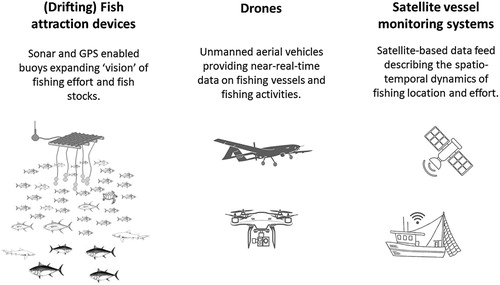
In this paper, we focus on the role of emerging MCS technologies used by state and private actors to generate spatial data for governing global fisheries. In doing so, we explore the mediating and formative role of technologies (Jasanoff, Citation2015) by questioning who is – and is not – in control over marine space and resources through informational flows (Mol, Citation2008; Toonen, Citation2013). We show that the use of information and sensing technologies in the marine environment opens up questions about the legitimacy and accountability of MCS practices in ocean governance. We base our argument on a comparison of three cases (see ). The first is the use of fish attraction devices (FADs), reflecting the under-water dimension of MCS in ocean governance. The second is air-borne surveillance by drones, and lastly, satellite monitoring from above the earth’s atmosphere. Given the nascent development of these MCS technologies in marine governance, the three cases are based on reviews of available literature, news articles, blogs and industry and NGO websites to elucidate the attitudes of key protagonists promoting these technologies.
Figure 1. Three cases of monitoring, control and surveillance technologies.
The structure of our paper is as follows. Section 2 outlines our analytical framework on assembling ocean territories. Section 3 then presents the three MCS cases in the water (FADs), air (drones) and space (satellites). Section 4 discusses these cases before Section 5 outlines our conclusions on the future role of MCS technologies in contributing to greater transparency and contributing to improved fisheries management.
2. Technology, space and fisheries governance
The governance of marine resources is undergoing a shift from state to non-state or private forms of control linked to the provision and interpretation of information (van Tatenhove, Citation2016). Under the United Nations Convention on the Law of the Sea (UNCLOS), the management of straddling and highly migratory fish stocks was based around the division of rights and responsibilities within and across political (national) boundaries and the formation of multi-lateral regional fisheries management organisations (RFMOs) (UNCLOS, Citation1982). The rise of MCS technologies represents a second wave of control over the oceans based on the remote collection and control of information. Whereas UNCLOS was based on the division of the ocean into boundaries that created large homogenous swathes of ocean surface, water column and benthic habitat, the MCS technologies have led to novel spatial configurations that are far from homogenous and stylised (Bush & Mol, Citation2015). As such ocean governance is now dependent on control over technologies and information, both in, on and (far) above and beyond the ocean’s water.
The implication is that states are not the only actors involved in the creation of spatial jurisdictions within which fisheries and other oceanic activities are governed. The highly mobile nature of fisheries across often poorly regulated oceans and seas has driven private actors, including fishing companies and NGOs, to collect and communicate information on fishing activities – sometimes in partnership with states, other times not (Bush et al., Citation2017). New technologies controlled by private actors are creating new spatial territories based on the collection, storage and use of spatially referenced information.
As outlined by Mol (Citation2008) and Gupta (Citation2010), understanding the function and effectiveness of environmental governance, therefore, requires a new focus on who is (and who is not) in control over information. The decoupling of information and information technologies from the state also means that environmental governance is increasingly being de-territorialised (Mol & Spaargaren, Citation2005). States no longer have a monopoly on monitoring, reporting and/or verification within their sovereign spatial jurisdiction, nor in jurisdictions held in common with other states. In the context of fisheries, this means that states have to renegotiate access with private actors in order to know what is occurring within their sovereign waters, on sovereign (flagged) vessels and on fish stocks that exist within sovereign waters for at least part of their life cycle.
Our analysis focuses on how information and sensing technologies (designed for fisheries MCS) are used by private actors to configure new (and imagined) geographies of fisheries regulation. As such, we are interested in the process of territorialisation, or the negotiation over how boundaries defined through new information flows affect the inclusion/exclusion of environments and those that exploit them, and redefine the role of private and public regulation (Vandergeest & Peluso, Citation1995; Vandergeest, Ponte, & Bush, Citation2015). Analysing the process of territorialisation can, therefore, reveal how governance arrangements in complex environments, such as the ocean, manifest themselves as a layering of complimentary or competitive public and private rule making authorities over actors and resources in bounded localities (Vandergeest et al., Citation2015). It can also reveal how an assemblage of highly mobile and transient environments, regulations, materiality and movement (that represent different logics of governance) reveal relational space by exerting control over each other ‘at-a-distance’ (Bear, Citation2012). Such understandings of the (marine) environment point to the interaction between both territorialised resources and actors and de-territorialised forms of control through global flows and networks that attempt to regulate mobile environments and actors (Mol & Law, Citation1994; Urry, Citation2003). Building on Bush and Mol (Citation2015), governing the sustainability of these resources in places, therefore, means identifying the assemblage of material, finances, regulation and information flows that constitute and configure dynamic and transient territories, as well as who is control of these flows, and by default, territories.
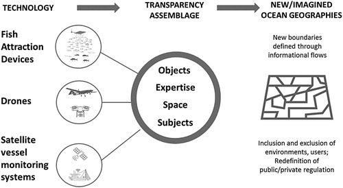
Following Vandergeest et al. (Citation2015), we assess territorialisation as a process of interaction between objects, space, subjects and expertise in defining information flows that exert influence over oceanic resources and activities. Objects of concern include not only the targeted biological resources that are the subject of fishing pressure, but also material objects that are related to (or impacted by) the production process, such as fishing gear, by-catch, birds, turtles, dolphins or broader marine eco-systems. It has been noted that the materiality of these objects, and the marine environment in which they operate, render real boundaries problematic and fluid due to the material movement of fish, vessels and currents (Bear & Eden, Citation2008). Space points to the physical or relational boundaries within which objects of concern (and simultaneously objects of non-concern) associate, either as a fixed spatially delimited sustainability territory such as a (no)fishing ‘zone’ or protected ‘area’ (Bear, Citation2012). Subjects are actors whose practices need to be subjected to assessment and surveillance by different MCS technologies, including fishers, traders, processors and/or government agencies (Vandergeest et al., Citation2015). Expertise is defined as a bundle of codified and concentrated knowledges that is controlled by ‘experts’ (Vandergeest & Peluso, Citation1995). These experts include those who define the information systems that are used and have the exclusive capacity and qualifications to create or apply these knowledges, produce the rules that define the central objects of concern, and thus the ecologies that need to be protected. As such, expertise goes far beyond states and includes private actors operating through the control of technologies.
Using this framework, we analyse how information and sensing technologies make objects of concern visible (and potentially legible), and in doing so configure new informational territories controlled by private actors. We do this by focusing on three assemblages of information and surveillance technologies, each of which opens up a new spatial dimension of ocean governance: water, air and space (). While each technology has a material basis and is being practiced to some extent, they are all in a nascent stage of development. Their influence at this point, therefore, is largely limited to what Jasanoff (Citation2015) refers to as the creation of collective (sociotechnical) imaginaries, or ‘collectively held and performed visions of desirable futures’ (p. 28). Given the distant, off-shore, invisible and frontier-like nature of the marine environment, the collectively performed vision of sustainable oceans is by definition imagined to the extent that they are mediated and (per-)formed by technologies and information. It is the understanding of how this normativity is linked to technology and a sense of community that allows us, combined with the territorialisation framework, to unpack different transparency assemblages related to the socio-spatial configurations of the marine environment. In the next section, we explore territorialisation of imagined geographies through three MCS technologies.
Figure 2. Assembling sustainable territories framework.
3. Three transparency assemblages
3.1. Water: drifting oceanic FADs
Drifting oceanic FADs (or d-FADs) are a form of fishing gear deployed in both the Exclusive Economic Zone (from 12 to a maximum of 200 nautical miles from the shoreline) of coastal states and high seas areas to increase the efficiency of purse seine fishing (Dempster & Taquet, Citation2004). Modern d-FADs are equipped with global positioning systems (GPS) and acoustic technology, which not only reduces the time needed to locate schools of fish, but also relays information on the volume of fish biomass aggregated underneath them, and even estimates of the species composition (Dagorn, Holland, Restrepo, & Moreno, Citation2013). Because of their capacity for sensing the composition of tuna stocks, d-FADs represent a new means of assessing both fish stocks and fishing practices of purse vessels. Using these new flows of data are seen as a key component of future management in order to better estimate (often underestimated) catches and fishing capacity (e.g. Tidd, Reid, Pilling, & Harley, Citation2016).
d-FADs and the tuna they exploit constitute objects of concern for fishery managers and conservationists. d-FADs are highly efficient at aggregating large schools of mixed tuna species sold to the global canned tuna market. In the Western and Central Pacific, they have played an important role in the one-third increase in tuna fishing effort over the last decade (Tidd et al., Citation2016). But the efficiency of d-FADs also poses a sustainability challenge. Not only do skipjack tuna associate under FADs but also overfished non-target (juvenile) bigeye tuna and endangered and threatened species of sharks, billfish and turtles (e.g. Bromhead, Foster, Attard, Findlay, & Kalish, Citation2003; Gilman, Citation2011). This does not mean that FADs are unsustainable per se. It is the largely unregulated expansion of their use that has put added pressure on the marine environment through excess fishing effort. The exact number of drifting oceanic d-FADs deployed each year is not known, but estimates range between 47,000 and 105,000 globally – with an increasing trend (Baske, Gibbon, Benn, & Nickson, Citation2012). In some parts of the oceans, the concentration of d-FADs is so high that they create a ‘perpetual artificial floating object habitat’ (Davies, Mees, & Milner-Gulland, Citation2014, p. 44). The effect of this ‘new habitat’ remains unclear. Some argue that FADs are leading to ecosystem-level changes by altering the migratory behaviour or predation patterns of tuna, and/or also decreasing fitness and increasing their natural mortality (Hallier & Gaertner, Citation2008).
The spatial extent of d-FADs is leading to new challenges and opportunities for regulators. On the one hand, d-FADs are directionless, moving along ocean currents through both national and high sea jurisdictions. While there is some coalescence of these currents, their distribution is largely random when seen from the perspective of fishing effort allocation, regulation and control (Bez, Walker, Gaertner, Rivoirard, & Gaspar, Citation2011). Despite scientific disagreement on their impact on tuna and other marine species, there is agreement that d-FADs affect the movement of tuna across space to a large degree (Dagorn, Bez, Fauvel, & Walker, Citation2013). d-FADs can in themselves be seen as ‘places’ in an oceanic environment given their role in attracting and facilitating the interaction of tuna (tuna and other species) and fishers (including both their capital and regulation). Equipped with information and sensing technologies, d-FADs also provide an enhanced picture of the spatial extent of the fishery as well as the status of fish stocks, especially when coupled with vessel monitoring systems (VMS) (Tidd, Pilling, & Harley, Citation2015). They, therefore, hold the potential to rethink how oceanic space is configured and how, in turn, fisheries subjects are created and regulation designed and implemented.
But while d-FADs offer an enhanced means of understanding what is happening on and below the water, the use of the information they generate is limited by ownership and independent assessment. d-FADs are owned by purse seine fishing companies, and while some limits to their deployment have been put in place in some oceans, this is not universal. In management and control of private FADs information is of key importance, but would require the cooperation of the fishers – who would, in turn, become the subjects for which such information would be used to manage fishing effort (Restrepo, Scott, & Koehler, Citation2016; Tidd et al., Citation2015). Programmes for FAD monitoring are in place in some regional fishery management organisations, but data on the location and use of FADs, including on the numbers released, remain poor (Baske et al., Citation2012; Dagorn et al., Citation2013; Taquet, Citation2013). As argued by Restrepo et al. (Citation2016), scientific ‘access to instrumented buoy tracking and echosounder data, with a suitable delay to ensure confidentiality, should be provided [to RFMOs] to help in efforts to examine the impacts of effort creep and assist in managing growing fleet capacity’ (p. 685). By doing so individual FADs could be linked to catch and in doing so ‘enable scientists to understand FAD density impacts on purse seine catch rates … which is critical for the sustainable management of the purse seine fishery’ (p. 685).
The expertise required to interpret FAD-related data is tied into the bigger question over control over and access to this data. The fragmented and highly competitive nature of boat ownership, coupled with the complexities of national catch licencing and enforcement (see Campling, Citation2012), severely complicates access and use of information on the status of public fishery resources. Discussions over greater state access to FAD-related information have been limited by the wider political economy of the tuna industry. Like many multi-lateral regimes, the RFMO system is constrained within the rights and interests of its member states (Cullis-Suzuki & Pauly, Citation2010). It is also constrained by the often disproportionate revenue they earn from licencing foreign-owned or chartered fishing fleets to operate in their sovereign waters, or high seas areas under the control of RFMOs (Campling, Citation2012). States and RFMOs alike are also ineffective at regulating FADs and FAD-related information because they are unable to keep up with the fast pace of technology development (Taquet, Citation2013). This means that while FADs offer a new means of surveillance of oceans, access and control over information remains limited by private interests.
3.2. Air: drones in (future) fishery surveillance
Drones are ‘unmanned aerial vehicles/systems’ operating under radiofrequencies and pre-programmed GPS-guided flight scripts that provide near-real-time data on the people, processes and landscapes they survey (Clarke, Citation2014). While drones originate from highly controversial military operations, the majority today have unarmed scientific, recreational and MCS applications (e.g. Hodgson, Kelly, & Peel, Citation2013; Sandbrook, Citation2015). Terrestrial applications of drones include the monitoring and spraying of agricultural crops (e.g. Peña, Torres-Sánchez, de Castro, Kelly, & López-Granados, Citation2013), anti-poaching strategies in conservation areas (e.g. Mulero-Pázmány, Stolper, Van Essen, Negro, & Sassen, Citation2014) and forest management and ecology (e.g. Anderson & Gaston, Citation2013; Paneque-Gálvez, McCall, Napoletano, Wich, & Koh, Citation2014). In fisheries management, drones are currently aspirational or experimental devices for MCS, but have the attention of policy-makers, environmentalists and researchers alike for combatting IUU fishing both near and off-shore (Bergseth, Russ, & Cinner, Citation2015; Kopaska, Citation2014).
The objects of concern related to IUU drone surveillance are a combination of fishers, vessels and fish stocks. Camera-equipped drones can detect fishing vessels and identify if they are registered in a given jurisdiction (Howard, Citation2016; Miller, Slicer, & Hanich, Citation2013). They can also observe the use of fishing gears deployed from both vessels and land, and they can relay near-real-time data on their location and movement (Kopaska, Citation2014). For example, in response to EU sanctions for IUU fishing banning export to the European market, the government of Belize deployed ‘quadcopter’ drones with live video streaming to extend the MCS capacity of their 70 personnel strong fishing enforcement department responsible for patrolling 390 km of coastline and more than 200 islands (Howard, Citation2016). Similar technologies are also being adopted by Palau, Jamaica and Costa Rica to detect and prosecute illegal fishing, and by NGOs like Sea Shepherd, Black Fish and Earthrace Conservation ‘to detect, record, and in some cases intercept vessels undertaking illegal activity, or provide enforcement departments with robust information to aid in prosecution’ (Andrews, Citation2016). Oceanagraphic data can also be collected by radiometers that can be used to determine the probability of (IUU) fishing events through so-called fluid lensing. Data on algal blooms or pollution events, as well as data on weather conditions and (surface) water temperature, are provided by meteorological or thermal instruments, all given an indication presence or absence of fish and/or vessels (Lukaczyk, Bieri, de Sousa, Levy, & McGillivary, Citation2016).
The spatial extent of drone use is determined by its design. Large drones with a payload of 200–900 kg can fly a radius of 500 km over a 2 day period, at an altitude of between 3 and 20 km. These drones can cover a large distance of coastline or even a large area of a countries national territory (defined by its exclusive economic zone). Micro or nano drones, with a payload of less than 5 kg and a range of less than 10 km, maximum flight time of 1 h and an altitude of 250 m useful for close scans yet therefore also costly (Anderson & Gaston, Citation2013). Using multiple drones, not only from land but from coast guard ships, is also a possibility in the future. The result might be a near total coverage of national jurisdictions, covering both coastal and near shore areas. This falls in the wider jurisdiction of states to survey passing vessels (UNCLOS, Part II, art. 2.2). But despite the expanding range of these technologies, questions have been raised over the capacity of drones to make the oceans legible (Lancaster, Dearden, Haggarty, Volpe, & Ban, Citation2017). For instance, their overall coverage may be extensive, but they are only able to give a snapshot of the ocean at any given moment, and provide limited insight on specific behaviours related to non-compliance.
The main subject of drone surveillance is fishers either deploying illegal gears or fishing no-take areas, or encroaching in or out of their licenced area. Despite the snapshot nature of drones, their main advantage is their stealth – given their speed and size they are difficult for fishers to see them coming (Howard, Citation2016). However, privacy issues do emerge around the use of drones given they are not selective in what they observe (Finn & Wright, Citation2012; Sandbrook, Citation2015). While states do maintain the right to survey objects of concern in their national territory, drones are indiscriminate in what they observe and therefore ‘enclose’ subjects. In her study of privacy concerns and drone usage in fighting IUU fishing on Belize, Wright (Citation2015) argues that rights at sea are linked to regulation a nation-state grants vessels in their territorial waters and flying under their flag, and concluded that privacy rights of fishermen had not been violated. Nevertheless, this becomes more complicated in Exclusive Economic Zones and the high seas. In these jurisdictions, states have no territorial claims but are responsible for vessels under their flag, including drones.
Drones and the data they capture draws together a nascent expert community to marine governance that includes the state, NGOs and multi-national aviation companies. Existing projects testing the use of drones are made up of coalitions between state agencies and established environmentalist organisations. In Belize, for instance, the Wildlife Conservation Society is partnering with the Belize Fisheries Department and a small (but growing) non-profit organisation called Conservation Drones (Howard, Citation2016; Wright, Citation2015). While drone use is fairly simple, technical expertise is required regarding design and script programming. Still, the expert community of drone usage is potentially very broad, as recreational camera-equipped drones are increasingly available through consumer retail stores (Sandbrook, Citation2015). One often highlighted project is the SoarOcean project funded by National Geographic and Lindblad Expeditions. This project aims to combine hobbyist drone technology with military-class surveillance counterparts to ‘provide demonstrated capabilities of low cost drone platforms to coastal communities looking to provide monitoring capacity for marine protected areas’ (SoarOcean, Citation2013). Given such aspirations, drone use and, therefore, surveillance may, in fact, lead to recreational and even commercial fishers using drones for scouting, fishing and potentially even surveillance of competitor (and illegal) fishers. The snapshot and non-selective nature of the information drones provide might, however, at the same time compromise inclusiveness of legal fishers.
3.3. Space: vessel monitoring and marine observation by satellites
The application of satellite-related tracking systems is widespread in fishery management, exemplified by the massive and intensive use of vessel monitoring systems (VMS). VMS is predominantly based on satellite-based GPS, with data fed into maps and models to describe and analyse the spatio-temporal dynamics and ultimately fishing effort of fishers (Witt & Godley, Citation2007). VMS has been deployed by states in a large number of fisheries at both the national and regional level (e.g. Chang, Citation2011; Hanich, Teo, & Tsamenyi, Citation2010). But in recent years, private vessel tracking services have emerge providing near-real-time data from satellite-based automatic identification systems (S-AIS) online, and often for free (McCauley et al., Citation2016). One of these new ‘open source’ systems is Global Fishing Watch, an online platform launched in 2016 to make data available to ‘anyone with an Internet connection’ and allows users to monitor when and where commercial fishing occurring around the world (Global Fishing Watch, Citation2017a). Across all systems, data can range from ‘simple’ static imageries based on aerial photography, such as freely available maps from GoogleEarth, to detailed information from earth observation satellites (Al-Abdulrazzak & Pauly, Citation2014; Stuart, Platt, & Sathyendranath, Citation2011). Like drones, satellite instruments also include radar altimeters and sensors collecting data on sea-surface temperature and algal blooms to indicate presence or absence of fish and fishing.
VMS and S-AIS data focus on fishing vessels as objects of concern in a global fight against IUU fishing (de Souza, Boerder, Matwin, & Worm, Citation2016; McCauley et al., Citation2016). Global Fishing Watch highlights ‘apparent fishing activity’, determined by an algorithm based on changes in vessel speed and direction (Global Fishing Watch, Citation2017a). Their map also links to the Marine Conservation Institute’s MPAtlas to detect whether fishing occurs within MPA borders (Global Fishing Watch, Citation2017d). Until recently, Global Fishing Watch used only data from S-AIS provided by private vessel tracking services, since VMS are nationally or regionally managed and have restricted data access – meaning that the great majority of fishers are still off the radar (McCauley et al., Citation2016).
Satellites are particularly important for visualising (IUU) fishing in inaccessible parts of the ocean and expose great potential for monitoring. Al-Abdulrazzak and Pauly (Citation2014), for example, used Google Earth images to count stationary fishing weirs and in turn estimate catch in the Persian Gulf. Global Fishing Watch allows viewing fishing activity in remote waters, such as near Heard Island and McDonald Islands (HIMI) that are important tooth fish fishing grounds yet for a large part designated as a ‘no take’ MPA (Daume, Morison, & BrandGardner, Citation2017; Global Fishing Watch, Citation2017b). Direct benefits for control and surveillance are less clear, especially in case of S-AIS since streaming comes with a time delay of minutes to hours, or more because private data owners often put a hold on making information available for free. Also, while VMS are primarily ship-to-shore systems, AIS are designed for two-way exchange and can be switched off at any time by either side. As McCauley et al. (Citation2016 ) point out, enforcement is, for now, dependent on having an AIS unit on board, not whether it is used.
VMS and S-AIS make fishers visible, identifiable, and, therefore, subject to scrutiny to those able to access its data. The power of these systems comes from their involuntary nature – with even turned off or ‘dark’ AIS illustrating some degree of (illegal) behaviour. Satellites also put governing authorities under a magnifying glass. Within their exclusive economic zones, governments can be held accountable for managing (il) legal practices. Al-Abdulrazzak and Pauly (Citation2014), for instance, compared their estimates about fishing in the Persian Gulf to governmental data which are feeding into FAO statistics and argued their results confer the unreliability of the latter. Similarly, Global Fishing Watch continues to push governments to disclose VMS data since S-AIS data covers only industrial-sized commercial fishing vessels. They have already succeeded in enrolling both Indonesia and Peru to deliver their VMS data, stating that with the help of these countries ‘ … Global Fishing Watch is establishing a new standard for transparency in the fishing industry … [and looks] forward to the day when all nations share their VMS data publicly with the world’ (Global Fishing Watch, Citation2017c). State competences to collect, hold and grant access to data is increasingly linked to their responsibility, or even obligation, of using this information for management and control, by themselves or others.
Expertise in satellite-based surveillance is largely reliant on a set of 10 countries (including the European Space Agency) and a handful of private orbit launchers with independent launch capability (UCS, Citation2016). Satellites are owned/operated by governmental agencies, commercial actors and research institutes/universities which has implications for data access. Given the interest in freely available information, private actors are increasingly entering the industry as providers offering near-real-time data from S-AIS for free (and historical data for purchase). The expert community brought together by Global Fishing Watch is particularly illustrative because it implies more inclusive participation as a ‘transparency tool’ to assist citizens, journalists and researchers to monitor and influence governments. It also targets seafood suppliers and fishermen to help them (self-) assess responsible fishing practices (Global Fishing Watch, Citation2017a). The platform also includes a broad range of non-state actors. It is led by two NGOs Oceana and SkyTruth, and the Google Earth Outreach team, funded by six large foundations including the Leonardo DiCaprio Foundation, and scientific and technical support comes from universities, research institutes, companies and commercial and non-profit data providers – now also including the Indonesian government (Global Fishing Watch, Citation2017d). Its most recent partnership is with the United States National Oceanic and Atmospheric Administration (NOAA), bringing in satellite-based night-time imageries to cross-match with Indonesian VMS data aimed to reveal the ‘dark’ fleet’, while NOAA’s scientists get access to VMS data that was previously out of their reach (Global Fishing Watch, Citation2018). Although new MCS applications of satellite data cause shifts in who is steering informational and governmental processes, and in doing so bring (illegal) fishing closer to the public’s eye, fishers seem to become more distanced – reduced to (identifiable) dots on a map, or at best addressed as just another fishery stakeholder.
4. Discussion
The three cases demonstrate the role that new MCS technologies are playing in setting new boundaries and creating new communities of ocean governance. The focus on transparency and information has de-territorialised the actors and means of control over ocean governance, as well as also re-territorialised existing (legal and illegal) fishing practices. These new informational territories are not Cartesian in their dimensions but relational, creating linkages through informational flows and networks between non-contiguous actors and objects above, across and below the ocean’s surface. Building on Vandergeest et al. (Citation2015), the cases also demonstrate that the technologies, although still emerging, are central to new governance assemblages that draw together disparate sets of objects, subjects and expertise to imagine and enact an ocean future without IUU fishing. The technologies are, therefore, ‘carriers’ of this normative view, and for each technology, the new boundaries are set around who is involved in the design and performance of legal or illegal fishing practices. But as we now go onto argue, while these new governance assemblages offer new opportunities for MCS they also raises questions of who the new governance actors are in the world’s oceans, as well as their legitimacy and ultimate effect on fishing performance.
The first observation is that MCS technologies produce new configurations of space that go beyond UNCLOS. The three cases show how MCS can render marine space as a complex topological surface, where boats, fish, FADs, fishing zones and MPAs intersect. Boundaries are as such not set by lines on the map, but by the visibility of fishing practices in often distant parts of the ocean. The technologies also expand our vision and identification of what objects are in fact ‘of concern’ (Bear & Eden, Citation2008). Objects of concern (which in the case of FADs are also objects of surveillance) are themselves nodes or places in a new topology of ocean surveillance, bringing together information, regulation and highly mobile fish and fishing practices (Bush & Mol, Citation2015). This may lead to again new and unprecedented applications. Global Fishing Watch has, for example, been used to map transhipments between large refrigerated ships and fishing vessels, since those on board of these fishing vessels are at sea for longer period of time and might be exposed to very bad working conditions, or even slave labour (Cutlip, Citation2017; Kroodsma, Miller, & Roan, Citation2017). Information flows are expanding the spatial boundaries, through flows, to land-bound ocean citizens, in case of (hobbyist) drones very directly while satellite-based MCS are opening up remote spaces. But in spite of these new configurations, the cases also show that state boundaries remain relevant, as illustrated by the impact of adding Indonesian VMS data to Global Fishing Watch.
Communities in which people and organisations work together in (per-)forming the ‘imaginary’ of combatting IUU fishing are defined by looking at who is made a subject and whose expertise is considered important. In all three cases, the subjects of surveillance are (pre-)defined by the available means for observation and the expertise (Song et al., Citation2018). This is key to the role of technology because who designs these technologies automatically becomes a new actor in the debate over who controls what, where and how (Suchman, Citation2002). Often out of sight, technical experts such as system engineers and programmers are the ones who turn fish and vessels into dots or algorithms, making fishing activities not only legible for others but also governable.
The extent to which fishers are (potentially) included as experts seem to relate to the distance between the technology and their fishing practice, as their involvement is most evident in the case of FADs, yet also possible in case of drones. There appears however to be a growing disconnect between expertise and the subjects they seek to make observable. These technologies render fishers homogenous. As a result, MCS technologies provide opportunities to watch, but not necessarily to see what and who is behind the fishing practices. Ultimately we are left with questions of whether these technologies are able to observe and thereby affect practices (Marx, Citation2016). Furthermore, these technologies tend towards the criminalisation of fishers by focusing on the imagery of specific events in time rather than understanding the root cause of illegal practices. This can be particularly egregious in coastal small-scale fisheries where categories of illegal are already ambiguous by unclear tenure and regulation (Jentoft & Chuenpagdee, Citation2017). In doing so, these technologies run the risk of increasing rather than decreasing the relational space between fishers and regulators, which runs counter to contemporary fisheries governance which emphasises interactive decision making (see, e.g. Kooiman, Bavinck, Chuenpagdee, Mahon, & Pullin, Citation2008).
At the same time, these technologies are democratising the oceans, bringing in wider-imagined communities of ocean citizens, such as in the case of Global Fishing Watch, looking up data, collectively participating in disciplining fishers, but also watching and pushing governments in taking action. But in all cases, the wider public has a marginalised role – perhaps with the exception of hobbyist drone pilots. In case of satellites, and Global Fishing Watch, in particular, the power to act as ocean citizens (defined as ‘anyone with an Internet connection’) is obscure. This limited influence is in disaccord with now well-embedded seafood certification schemes and other consumer-facing information tools, where the public has the possibility to be involved in their capacity as consumers.
While fishers and the wider public have ambiguous or even suppressed roles, all three cases clearly show private firms and NGOs, including their funders, are becoming key members of the expert communities (the new partnership between Global Fishing Watch and NOAA being the most recent example). Albeit in different constellations, these new actors hold central positions by controlling (access to) information. On the one hand, they offer new means of transcending the state politics that has limited marine governance, as seen with other private governance modes aiming to fill assumed regulatory voids in ocean governance (Gulbrandsen, Citation2010). But on the other hand, their involvement means we are faced with new challenges of control, and their own (lack of) transparency and accountability are to be scrutinised. Following Toonen (Citation2013), this, in turn, points to a future shift towards a marine informational governance, adding a range of questions around who owns and has the right to access information, to questions of who owns and has the right to access fish.
Building on observations in the wider private governance literature (e.g. Foley, Citation2013), the rise of private surveillance does not mean that the role of the state can be dismissed. All three cases demonstrate that the state has an important role to play moving forward. But following van Tatenhove (Citation2016), it is clear that the state will be increasingly confronted with greater scrutiny as well as competition, especially in high seas regions where they have no or little jurisdiction. In other cases, MCS technologies appear to reinforce state authority by policing national boundaries. States also appear to have surprising new areas of jurisdiction over MCS technologies. Across the three cases, for instance, state control appears to increase the further away from shore (also further into space) as a public mandate is needed to access and govern the air and space. Finally, regardless of the MCS technology, states will continue to provide legal, financial and discursive support to build up and enhance the imaginary of combatting IUU fishing.
5. Conclusions
MCS technologies can shape new spatial configurations which are not based on state jurisdictions alone, but assemblages of subjects, objects and experts are redefining these configurations. These newly created and largely imagined ocean communities extend well beyond fishers and states to ocean citizens, who can – to a greater of lesser extent – participate in using technologies to monitor practices or as watchdogs holding governments accountable for managing fisheries.
The rise of MCS is positive to the extent that technologies facilitate empowerment through transparency and make the oceans governable, creating a means to see what is going on in the last global commons. But there are also a number of dilemmas. First, technologies make fishing practices and governmental (re-)action visible, but do little to disclose the trade-offs of this newly held control – for example, the inherent and growing reliance on private actors to disclose ostensibly public information. Second, technology-induced empowerment is not the same for everyone, and may interfere with other participatory processes or holds bigger promises than can be realised. Third, shifts in power do not automatically improve transparency. As MCS technologies shift control over the oceans from the state to private actors (including NGOs), new forms of governance will be needed, including protocols for accountability and inclusive participation. Lastly, the risk is that technologies are enabling us to ‘watch’ (observe) rather than ‘see’ (interpret) what is going on in the oceans. This means that while MCS technologies reveal the topology of fishing activity in the oceans, they also tend to homogenise the objects and subjects practicing these activities. Without the capacity to see, we are unlikely to develop clear governance strategies for sustainable fishing practices.
There is a high level of commitment to combat IUU fishing, and public and private actors from all over the world join forces to improve MCS technology. If the vision of sustainable management in our biggest global commons is to be realised, challenges faced are not just about gathering and accessing more (accurate) data, or improving technicalities. Special attention should be paid in policy, practice and science to suppressed or excluded members in the imagined community of ocean citizens. Attention should also be given to the ongoing credibility of these technologies and the private actors that seek to control and apply the information. Understanding these new dimensions requires new imaginaries of what transparency assemblages can look like.
Disclosure statement
No potential conflict of interest was reported by the authors.
Notes on contributors
Hilde M. Toonen is a post-doctoral researcher at the Environmental Policy group of Wageningen University. Her research focuses on informational governance of the marine environment, with particular emphasis on innovative arrangements dealing with sustainability and (competing) spatial claims at sea.
Simon R. Bush is Professor of Environmental Policy at Wageningen University. His research focuses on the interaction between private and public environmental governance arrangements promoting the sustainable and equitable production, use and consumption of marine resources.
References
- Agnew, D. J., Pearce, J., Pramod, G., Peatman, T., Watson, R., Beddington, J. R., & Pitcher, T. J. (2009). Estimating the worldwide extent of illegal fishing. PLoS ONE, 4(2), e4570.
- Al-Abdulrazzak, D., & Pauly, D. (2014). Managing fisheries from space: Google earth improves estimates of distant fish catches. ICES Journal of Marine Science, 71(3), 450–454.
- Anderson, K., & Gaston, K. J. (2013). Lightweight unmanned aerial vehicles will revolutionize spatial ecology. Frontiers in Ecology and the Environment, 11(3), 138–146.
- Andrews, S. (2016). Drones: Keeping a watchful eye on illegal fishing. The Fish Site.
- Ardron, J. A., Rayfuse, R., Gjerde, K., & Warner, R. (2014). The sustainable use and conservation of biodiversity in ABNJ: What can be achieved using existing international agreements? Marine Policy, 49, 98–108.
- Baske, A., Gibbon, J., Benn, J., & Nickson, A. (2012). Estimating the use of drifting fish aggregation devices (FADs) around the globe. Washington, DC: PEW Environmental Group.
- Bear, C. (2012). Assembling the sea: Materiality, movement and regulatory practices in the cardigan Bay scallop fishery. Cultural Geographies, 20(1), 21–41. doi: 10.1177/1474474012463665
- Bear, C., & Eden, S. (2008). Making space for fish: The regional, network and fluid spaces of fisheries certification. Social & Cultural Geography, 9(5), 487–504. doi: 10.1080/14649360802224358
- Bergseth, B. J., Russ, G. R., & Cinner, J. E. (2015). Measuring and monitoring compliance in no-take marine reserves. Fish and Fisheries, 16(2), 240–258.
- Berkes, F., Hughes, T. P., Steneck, R. S., Wilson, J. A., Bellwood, D. R., Crona, B., … Norberg, J. (2006). Globalization, roving bandits, and marine resources. Science, 311(5767), 1557–1558.
- Bez, N., Walker, E., Gaertner, D., Rivoirard, J., & Gaspar, P. (2011). Fishing activity of tuna purse seiners estimated from vessel monitoring system (VMS) data. Canadian Journal of Fisheries and Aquatic Sciences, 68(11), 1998–2010.
- Bromhead, D., Foster, J., Attard, R., Findlay, J., & Kalish, J. (2003). A review of the impacts of fish aggregating devices (FADs) on tuna fisheries: Final report to the Fisheries Resources Research Fund. Canberra: Bureau of Rural Sciences.
- Bush, S. R., Bailey, M., van Zwieten, P., Kochen, M., Wiryawan, B., Doddema, A., & Mangunsong, S. C. (2017). Private provision of public information in tuna fisheries. Marine Policy, 77, 130–135.
- Bush, S. R., & Mol, A. P. (2015). Governing in a placeless environment: Sustainability and fish aggregating devices. Environmental Science & Policy, 53, 27–37.
- Campling, L. (2012). The tuna ‘commodity frontier’: Business strategies and environment in the industrial tuna fisheries of the western Indian ocean. Journal of Agrarian Change, 12(2–3), 252–278.
- Chang, S.-K. (2011). Application of a vessel monitoring system to advance sustainable fisheries management – benefits received in Taiwan. Marine Policy, 35(2), 116–121.
- Clarke, R. (2014). Understanding the drone epidemic. Computer Law & Security Review, 30(3), 230–246. doi: 10.1016/j.clsr.2014.03.002
- Cullis-Suzuki, S., & Pauly, D. (2010). Failing the high seas: A global evaluation of regional fisheries management organizations. Marine Policy, 34(5), 1036–1042. doi: 10.1016/j.marpol.2010.03.002
- Cutlip, K. (2017). Flag of convenience or clock of malfeasance? Retrieved from http://globalfishingwatch.org/
- Dagorn, L., Bez, N., Fauvel, T., & Walker, E. (2013). How much do fish aggregating devices (FADs) modify the floating object environment in the ocean? Fisheries Oceanography, 22(3), 147–153.
- Dagorn, L., Holland, K. N., Restrepo, V., & Moreno, G. (2013). Is it good or bad to fish with FADs? What are the real impacts of the use of drifting FADs on pelagic marine ecosystems? Fish and Fisheries, 14(3), 391–415.
- Daume, S., Morison, A. & BrandGardner, S. (2017). Heard island and McDonald islands (HIMI) toothfish fishery MSC full assessment report. Emeryville, CA: S. G. Services.
- Davies, T. K., Mees, C. C., & Milner-Gulland, E. (2014). The past, present and future use of drifting fish aggregating devices (FADs) in the Indian ocean. Marine Policy, 45, 163–170.
- Dempster, T., & Taquet, M. (2004). Fish aggregation device (FAD) research: Gaps in current knowledge and future directions for ecological studies. Reviews in Fish Biology and Fisheries, 14(1), 21–42.
- de Souza, E. N., Boerder, K., Matwin, S., & Worm, B. (2016). Improving fishing pattern detection from satellite AIS using data mining and machine learning. PLoS ONE, 11(7), e0158248.
- Doulman, D. J. (1994). Technical assistance in fisheries monitoring control and surveillance: A historical perpective of FAO’s role. Rome: FAO.
- FAO. (2001). International plan of action to prevent, deter and eliminate illegal, unreported and unregulated fishing. Rome: FAO.
- Finn, R. L., & Wright, D. (2012). Unmanned aircraft systems: Surveillance, ethics and privacy in civil applications. Computer Law & Security Review, 28(2), 184–194.
- Foley, P. (2013). National government responses to Marine Stewardship Council (MSC) fisheries certification: Insights from Atlantic Canada. New Political Economy, 18(2), 284–307.
- Gilman, E. L. (2011). Bycatch governance and best practice mitigation technology in global tuna fisheries. Marine Policy, 35(5), 590–609.
- Global Fishing Watch. (2017a). About the project. Retrieved from http://globalfishingwatch.org/the-project
- Global Fishing Watch. (2017b). Map. Retrieved from http://globalfishingwatch.org/map/
- Global Fishing Watch. (2017c). A new era in transparency. Retrieved from http://globalfishingwatch.org/
- Global Fishing Watch. (2017d). Partners. Retrieved from http://globalfishingwatch.org/partners
- Global Fishing Watch. (2018). Bright lights reveal the ‘dark’ fleet. Retrieved from http://globalfishingwatch.org/
- Gulbrandsen, L. H. (2010). Transnational environmental governance: The emergence and effects of the certification of forest and fisheries. Cheltenham: Edward Elgar.
- Gupta, A. (2010). Transparency in global environmental governance: A coming of age? Global Environmental Politics, 10(3), 1–9.
- Hallier, J.-P., & Gaertner, D. (2008). Drifting fish aggregation devices could act as an ecological trap for tropical tuna species. Marine Ecology Progress Series, 353, 255–264.
- Hanich, Q., Teo, F., & Tsamenyi, M. (2010). A collective approach to Pacific islands fisheries management: Moving beyond regional agreements. Marine Policy, 34(1), 85–91.
- Hodgson, A., Kelly, N., & Peel, D. (2013). Unmanned aerial vehicles (UAVs) for surveying marine fauna: A dugong case study. PLoS ONE, 8(11), e79556.
- Howard, B. C. (2016). Watch how drones fight pirate fishing from the sky. National Geographic.
- Jasanoff, S. (2015). Future imperfect: Science, technology, and the imaginations of modernity. In S. Jasanoff & S. H. Kim (Eds.), Dreamscapes of modernity: Sociotechnical imaginaries and the fabrication of power (pp. 1–47). Chicago, IL: University of Chicago Press.
- Jentoft, S., & Chuenpagdee, R. (2017). From rhetoric to reality: Implementing the voluntary guidelines for securing sustainable small-scale fisheries. In S. Jentoft, R. Chuenpagdee, M. J. Barragán-Paladines, & N. Franz (Eds.), The small-scale fisheries guidelines (pp. 789–812). Dordrecht: Springer.
- Klemas, V. (2013). Fisheries applications of remote sensing: An overview. Fisheries Research, 148, 124–136.
- Kooiman, J., Bavinck, M., Chuenpagdee, R., Mahon, R., & Pullin, R. (2008). Interactive governance and governability: An introduction. The Journal of Transdisciplinary Environmental Studies, 7(1), 1–11.
- Kopaska, J. (2014). Drones – A fisheries assessment tool? Fisheries, 39(7), 319–319.
- Kroodsma, D. A., Miller, N. A., & Roan, A. (2017). The global view of transhipments – preliminary findings. Retrieved from http://globalfishingwatch.org/publications
- Lancaster, D., Dearden, P., Haggarty, D. R., Volpe, J. P., & Ban, N. C. (2017). Effectiveness of shore based remote camera monitoring for quantifying recreational fisher compliance in marine conservation areas. Aquatic Conservation: Marine and Freshwater Ecosystems, 27(4), 804–813.
- Lukaczyk, T., Bieri, T., de Sousa, J. T., Levy, J., & McGillivary, P. A. (2016). Unmanned aircraft as mobile components of Ocean Observing Systems for management of marine resources. OCEANS 2016 MTS/IEEE Monterey.
- Marx, G. T. (2016). Windows into the soul: Surveillance and society in an age of high technology. Chicago, IL: Chicago University Press.
- Maxwell, S. M., Hazen, E. L., Lewison, R. L., Dunn, D. C., Bailey, H., Bograd, S. J., … Crowder, L. B. (2015). Dynamic ocean management: Defining and conceptualizing real-time management of the ocean. Marine Policy, 58, 42–50. doi: 10.1016/j.marpol.2015.03.014
- McCauley, D. J., Woods, P., Sullivan, B., Bergman, B., Jablonicky, C., Roan, A., … Worm, B. (2016). Ending hide and seek at sea. Science, 351(6278), 1148.
- Miller, D. G. M., Slicer, N. M., & Hanich, Q. (2013). Monitoring, control and surveillance of protected areas and specially managed areas in the marine domain. Marine Policy, 39, 64–71. doi: 10.1016/j.marpol.2012.10.004
- Mol, A. P. (2008). Environmental reform in the information age. Cambridge: Cambridge University Press.
- Mol, A., & Law, J. (1994). Regions, networks and fluids: Anaemia and social topology. Social Studies of Science, 24(4), 641–671.
- Mol, A. P., & Spaargaren, G. (2005). From additions and withdrawals to environmental flows: Reframing debates in the environmental social sciences. Organization & Environment, 18(1), 91–107.
- Molenaar, E. J. (2005). Addressing regulatory gaps in high seas fisheries. The International Journal of Marine and Coastal Law, 20(3), 533–570.
- Mulero-Pázmány, M., Stolper, R., Van Essen, L., Negro, J. J., & Sassen, T. (2014). Remotely piloted aircraft systems as a rhinoceros anti-poaching tool in Africa. PLoS ONE, 9(1), e83873.
- Österblom, H. (2014). Catching up on fisheries crime. Conservation Biology, 28(3), 877–879.
- Paneque-Gálvez, J., McCall, M. K., Napoletano, B. M., Wich, S. A., & Koh, L. P. (2014). Small drones for community-based forest monitoring: An assessment of their feasibility and potential in tropical areas. Forests, 5(6), 1481–1507.
- Peña, J. M., Torres-Sánchez, J., de Castro, A. I., Kelly, M., & López-Granados, F. (2013). Weed mapping in early-season maize fields using object-based analysis of unmanned aerial vehicle (UAV) images. PLoS ONE, 8(10), e77151.
- Petrossian, G. A. (2015). Preventing illegal, unreported and unregulated (IUU) fishing: A situational approach. Biological Conservation, 189, 39–48.
- Restrepo, V., Scott, G., & Koehler, H. (2016). Options for managing FAD impacts on target tuna stocks. Collected Volume of Scientific Papers ICCAT, 72(3), 681–696.
- Sandbrook, C. (2015). The social implications of using drones for biodiversity conservation. Ambio, 44(4), 636–647.
- SoarOcean. (2013). Soarocean. Low cost drones for ocean conservation. Retrieved from http://soarocean.org/
- Song, A. M., Johnsen, J. P., & Morrison, T. H. (2018). Reconstructing governability: How fisheries are made governable. Fish and Fisheries, 19(2), 377–389. doi: 10.1111/faf.12262
- Stuart, V., Platt, T., & Sathyendranath, S. (2011). The future of fisheries science in management: A remote-sensing perspective. ICES Journal of Marine Science, 68(4), 644–650.
- Suchman, L. A. (2002). Practice-based design of information systems: Notes from the hyperdeveloped world. The Information Society, 18(2), 139–144.
- Sumaila, U. R., Alder, J., & Keith, H. (2006). Global scope and economics of illegal fishing. Marine Policy, 30(6), 696–703.
- Sumaila, U. R., Jacquet, J., & Witter, A. (2017). When bad gets worse: Corruption and fisheries. In A. Williams & P. Le Billon (Eds.), Corruption, natural resources and development: From resource curse to political ecology (pp. 93–104). Cheltenham: Edward Elgar.
- Taquet, M. (2013). Fish aggregating devices (FADs): Good or bad fishing tools? A question of scale and knowledge. Aquatic Living Resources, 26(1), 25–35.
- Tidd, A. N., Pilling, G. M., & Harley, S. (2015). Examining productivity changes within the tropical WCPO purse seine fishery. Pohnpei: WCPFC.
- Tidd, A. N., Reid, C., Pilling, G. M., & Harley, S. J. (2016). Estimating productivity, technical and efficiency changes in the Western Pacific purse-seine fleets. ICES Journal of Marine Science: Journal du Conseil, 73(4), 1226–1234. doi: 10.1093/icesjms/fsv262
- Toonen. (2013). Sea@shore: Informational governance in marine spatial conflicts at the North Sea (PhD thesis). Wageningen UR.
- Toonen, H. M., & Mol, A. P. J. (2016). Governing the marine environment through information: Fisheries, shipping, and tourism. In B. H. MacDonald, S. S. Soomai, E. M. De Santo, & P. G. Wells (Eds.), Science, information and policy interface for effective coastal and ocean management (pp. 125–151). Boca Raton, FL: CRC Press.
- UCS. (2016). UCS satellite database. Retrieved from http://www.ucsusa.org/nuclear-weapons/space-weapons/satellite-database
- United Nations Convention on the Law of the Sea of 10 December 1982. (1982).
- Urry, J. (2003). Global complexity. Cambridge: Polity Press.
- Vandergeest, P., & Peluso, N. L. (1995). Territorialization and state power in Thailand. Theory and Society, 24(3), 385–426.
- Vandergeest, P., Ponte, S., & Bush, S. (2015). Assembling sustainable territories: Space, subjects, objects, and expertise in seafood certification. Environment and Planning A, 47(9), 1907–1925.
- van Tatenhove, J. P. (2016). The environmental state at sea. Environmental Politics, 25(1), 160–179.
- Witt, M. J., & Godley, B. J. (2007). A step towards seascape scale conservation: Using vessel monitoring systems (VMS) to map fishing activity. PLoS ONE, 2(10), e1111.
- Wright, B. (2015). Big brother watching mother nature: Conservation drones and their international and domestic privacy implications. Vermont Journal of Environmental Law, 17, 138.