
The common theme for the articles in this special issue of the Journal of Map and Geography Libraries is “provenance.” While some in map librarianship may consider this an archival term and thusly not germane, we the editors, Ronald Grim and Ryan Moore, who started our careers in archival settings and moved on to work for the Library of Congress, Geography and Map Division, though at separate times, propose that provenance is very useful for map librarians.
Forgoing the risks associated with assumptions, we define the term, by way of the Society of American Archivists, “provenance is a fundamental principal, referring to the individual, family, or organization that created or received the items in a collection. The principle of provenance or the respect des fonds dictates that records of different origins be kept separate to preserve their context.” Of course, it makes sense for archivists to examine groups of information and to keep common threads intact, thereby highlighting the purpose of the whole, with varying levels of description for the constituent parts. However, we think it is worthwhile for map librarians to adopt this approach, where applicable, to enhance description. In other words, the better a cartographic item’s total history and purpose are described, the more valuable an item or a group of items is for research. Case in point, coeditor Moore notes how the Library of Congress, Geography and Map Division cataloged a set of maps of Great Britain, generically describing them as depictions of Great Britain in 1941 by the German General Staff. Upon examination, it was determined that these maps were, in fact, part of a German military feasibility study for a cross-channel invasion! Moore shared this information with cataloger extraordinaire, Charles Peterson, now retired, who reads German like Moore. Peterson then developed a richer record that incorporated provenance.
To similar ends, this special edition’s five articles, written by map librarians in North America and Europe, explore the role of provenance. All discuss map or atlas collections within library settings with a focus on the origins of specific cartographic materials, examining such concerns as who created or first owned them, how they were used or consumed, and how they were acquired by the library. Mentioned in the articles are proposals for cataloging and digitizing the maps, moreover, including in those records information about provenance.
We begin our exploration of provenance with an article by coeditor Grim that argues that no clue should be overlooked, whether it may be acquisition stamps, handwritten notes or acquisition documentation. He examines a small but exceptional group of annotated atlases acquired by the Boston Public Library during the last half of the nineteenth and early twentieth centuries. These annotations and alterations, along with published acquisition reports and genealogical records, demonstrate the importance of preserving such evidence. Furthermore, it can be used to reconstruct hidden yet intriguing stories of personal and institutional provenance.
German cartographic historian Thomas Horst presents a story of full circle. He traces the history of the Bavarian Army Library’s map collection from the Library’s founding in the early nineteenth century until the present. He reconstructs its complex provenance through German unification, World Wars I and II, its capture by U.S. Army personnel at the conclusion of the latter war, its unprocessed sojourn for 16 years in the Library of Congress, its eventual return to Germany, and its current unfortunate situation as a hidden collection, which is divided among several German institutions. He advocates for its reunification, if not physically, but through cataloging and digitization.
Out of the bombast of World War II, captured German and Japanese maps were acquired by American libraries, then languished for decades. They how, however, are receiving renewed attention. Two articles, by two pairs of authors discuss the experience of several academic and research libraries that received maps captured and distributed by the U.S. Army following the war. What makes these stories of provenance different from the Bavarian Army Library’s map collection journey is that these captured cartographic materials were not returned to their original institutional settings but instead are retained by several map libraries in the United States. Julie Sweetkind-Singer, Stanford University, and Greg March, University of Tennessee Knoxville, relate their experience dealing with both captured German and Japanese maps, with the eventual transfer of the Tennessee collection to Stanford. Whereas, Susan Powell and Heiko Muhr, representing the University of California Berkeley, focus on the university’s captured German World War II map collection, which also integrates captured maps transferred from the University of California, Riverside. Both pairs of authors address the complex history of original map production, the seizure of these maps by the U.S. Army, and their distribution to 35 academic libraries throughout the United States, as documented in an Army Map Service letter discovered during their research. Considered together, these two articles advocate including the maps series’ complex production and ownership history in catalog records, as well as for cooperation among the libraries that hold similar materials to process these map series and to share catalog records and digital images, to provide wider access to them.
The final article talks of literally climbing a mountain of disorganized maps to find one among them. Paige Andrew, Linda Musser, and Laura McElfresh, a team of librarians representing Pennsylvania State University and the University of Minnesota, explore nearly every aspect of the history of the Library of Congress Geography and Map Division’s summer projects, which were held almost annually from 1950 to the beginning of the twenty-first century. In addition to a deep exploration on the motivations, tasks, participants, and benefits of the program from multiple perspectives, it also contributes to the common theme of provenance. The underlying concept of this program encouraged many North American map libraries to send a representative to the Library of Congress to assist the Geography and Map Division in managing the large arrearages accumulated at the end of World War II. In exchange, these summer program participants selected maps and atlases from the Library’s duplicate stock, thus providing a major acquisition source for many institutions to build their map collections during the second half of the twentieth century. Today’s map librarians will find that a common feature of these distributed items is a library stamp marking it as a duplicate from the Library of Congress, and often a second stamp indicating the institution (such as the Army Map Service) that contributed the item to the Library’s surplus stock.
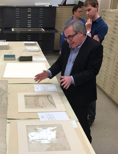
This issue is dedicated to Edward J. Redmond (1962–2021), Senior Reference Specialist and Vault Curator in the Geography and Map Division, Library of Congress, who passed February 2, 2021. Ed had worked in the Geography and Map Division since 1988. Several of the authors in this issue will attest that Ed provided unwavering reference assistance to the map community, which is reflected in the numerous acknowledgments in scholarly books and articles, thanking him for excellent advice and locating pertinent research material among the Library’s vast cartographic holdings. Both of the editors acknowledge that finding cartographic items in the Library of Congress, Geography and Map Division can be a daunting challenge because of the millions of items, many not cataloged. Ed, however, was a librarian who could find the proverbial needle in a haystack and then some. Concerning matters of provenance, Ed was an authority on the maps of George Washington and compiled a list of the “president, mapmaker’s” surveys. Out of respect to him and his life’s work, we include links to his writing and videos, in which he appears, discussing the topic. His knowledge, love of maps, and wry sense of humor will be missed.
Edward J. Redmond: List of Publications and Online Presentations
For a fuller accounting of Ed Redmond’s professional career, we refer readers to a remembrance written by Ralph E. Ehrenberg, “Edward J. Redmond (1962–2021), Noted Authority on George Washington’s Maps,” The Portolan, no. 110 (Spring 2021), p. 67. Not included in the former article was a listing of his writings and public presentations, which are enumerated here:
George Washington Papers: Online Essays
Tracing the Maps in George Washington’s Life https://www.loc.gov/collections/george-washington-papers/articles-and-essays/george-washington-survey-and-mapmaker/tracing-the-maps-in-george-washingtons-life/
Washington as Public Land Surveyor https://www.loc.gov/collections/george-washington-papers/articles-and-essays/george-washington-survey-and-mapmaker/washington-as-public-land-surveyor/
Washington as Land Speculator https://www.loc.gov/collections/george-washington-papers/articles-and-essays/george-washington-survey-and-mapmaker/washington-as-land-speculator/
List of Early Maps and Surveys https://www.loc.gov/collections/george-washington-papers/articles-and-essays/george-washington-survey-and-mapmaker/list-of-early-maps-and-surveys/
Worlds Revealed: Geography and Maps at the Library of Congress: Blog Essays
“Eastern Branch of the Potomac River” or “Anacostia River”? A Cartographic Curiosity… December 28, 2020
Mapping A World Of Cities. September 2, 2020
The Atlantic Neptune: An Unparalleled Collection of British Nautical Charts. August 7, 2020
18th Century Maps of North America: Perception vs. Reality. June 10, 2020
Canals of Washington, DC. April 22, 2020
Cartography of Contagion. April 3, 2020
Surveying: The Art of Measuring Land, Part Two. December 18, 2019
Surveying: The Art of Measuring Land, Part One. November 20, 2019
Sailing the Early Seas with Portolan Charts. September 18, 2019
Millard Fillmore: Lawyer, President, and Map Collector! July 18, 2019
Connecting Collections: The Battle of Trenton and Princeton. December 19, 2018
Mappy Thanksgiving! November 21, 2018
Exploring County Land Ownership Maps. September 27, 2018
Baseball Stadiums and Maps: Chicago. July 6, 2018
Places in Civil War History: Maps of the Peninsula Campaign, Part 2. June 7, 2018
Places in Civil War History: Maps of the Peninsula Campaign, Part 1. May 9, 2018
Places in Civil War History: Pivotal Virginia Battles, By Land and Sea. March 14, 2018
Places in Civil War History: The Anaconda Plan and Union Victories in Tennessee. February 15, 2018
The Early Years of Alexandria, Virginia. January 31, 2018
Places in Civil War History: The Battle of Dranesville. December 20, 2017
Houses of Government. October 12, 2017
Places in Civil War History: Aerial Reconnaissance and Map Marketing. August 16, 2017
Places in Civil War History: The First Battle of Bull Run. July 19, 2017
Places in Civil War History: The Battle of Rich Mountain. July 12, 2017
Places in Civil War History: Surveys of the Gulf Coast. June 21, 2017b
Places in Civil War History: Tensions in Northern Virginia and Defending Washington. June 15, 2017
Places in Civil War History: Virginia Geography. May 25, 2017
Places in Civil War History: Tennessee Secession and Fortress Monroe. May 11, 2017
Places in Civil War History: Fort Sumter and Virginia Secession. April 27, 2017
Places in American Civil War History: Preparation for War. April 18, 2017
Places in American Civil War History: Maps Depicting Prologue to War and Secession, March 1861. March 31, 2017
A Mother’s Day Map from the Civil War. May 17, 2016
British Spy Map of Lexington and Concord: A Detective Story. April 18, 2016
Other Publications and Presentations
“George Washington’s Activities in Securing Land Grants along the Western Frontiers of Virginia, 1767–1799 and List of Maps Drawn or Annotated by George Washington.” M.A. Thesis, West Chester University, 1991
“The George Washington Map Collection in the Library of Congress,” The Portolan 44 (Spring, 1999)
George WASHINGTON. ‘The Mapmaker of Mount Vernon’ in The Early America Review, vol. 5, no. 1 (Winter-Spring 2001)
Mapping the Past - The Surveys of George Washington, lecture presented on February 24, 2012 at Washington College, online video: https://youtu.be/IZ2FNtpInmg
“Civil War Cartography Then and Now,” (with Jacqueline V Nolan), LCM/Library of Congress Magazine (November/December 2012), 12–13. https://www.google.com/books/edition/Library_of_Congress_Magazine/gNsl80dyeU8C?hl=en&gbpv=1&dq=Edward+J.+Redmond,+map&pg=RA1-PA12&printsec=frontcover
Exhibition curator, Mapping a Growing Nation: From Independence to Statehood, ongoing exhibition opened September 1, 2016. Online presentation: https://www.loc.gov/exhibits/mapping-a-growing-nation/
“Library of Congress G&M: Recent Acquisition” The Portolan 104 (Spring, 2019)
Ed Redmond, leading a tour of the Library of Congress, Geography and Map Division Vault, enthusiastically describes two maps drawn by George Washington.
Ronald E. Grim, Library of Congress and Boston Public Library (retired) and Ryan J. Moore, MA, MLS, Library of Congress, Geography and Map Division, The opinions and views stated in this publication are their Own.
Coeditors of the Provenance issue
Correction Statement
This article has been republished with minor changes. These changes do not impact the academic content of the article.