
Abstract
Annually, rivers close to communities within Sekondi-Takoradi Metropolis overflow their banks, especially during the rainy seasons; displacing thousands of residents. Despite this, little is known about the coping strategies used by the residents when flooding occurs. Using mixed method, this article examines the coping strategies employed by households within three communities at risk. Two hundred and seven heads of households residing in Eshiem, Kansawurodo and Whindo were systematically selected to fill in questionnaires, while six key informants comprising chiefs and representatives of flood management institutions were chosen for in-depth interviews. The findings suggest that the commonest coping strategies adopted by residents in all the communities were: temporary vacation of homes, transfer of relevant properties to neighbors and building of flood steps. However, the coping strategies employed by the residents varied by communities, although the majority of them resorted to self-sustaining mechanisms in restoring their losses.
Keywords:
Introduction
Research has shown that about 85 percent of households vulnerable to flooding live in developing countries and as a result, such countries experience the majority of flood-related deaths (ProAct Network Citation2008, Inter-Parliamentary Union [IPU] and International Strategy for Disaster Reduction [ISDR] Citation2010). One country that ranks high among such vulnerable countries is Ghana (ISDR and World Bank Citation2009). Ghana has well documented policies to address flooding and its related implications. For instance, among other functions, the National Water Policy of 2007 was established to issue early warnings for flooding and to enforce buffer zone laws among people residing in unapproved places (Institute of Local Government Studies & International Water Management Institute Citation2012). In addition, the government of Ghana, through the Ministry of Local Government and Rural Development, introduced ‘The Blue Agenda’ in 2010 to address flooding and its related perils. Specifically, public education of residents in flood-prone areas and enforcement of building regulations were inducted under this agenda. The agenda also aimed at providing drainage and flood control measures in urban communities (ILGS and IWMI Citation2012). The Environmental Sanitation Policy of 2012 also ensures that governmental bodies put in plans to restrict the creation of new slums, ensure efficient and effective management of drainage systems and promote private sector participation in flood control (ILGS and IWMI, Citation2012).
Despite the availability of the state policies to curb flooding, the country is struggling to lessen flood related hazards, especially in the urban zones (Ahadzie and Proverbs Citation2011). Suburbs within Accra, Kumasi, Cape Coast and Sekondi-Takoradi get flooded during the rainy seasons (Yeboah and Aklorbortu Citation2009). In 2009 for example, heavy rains caused mayhem in several parts of the Sekondi-Takoradi Metropolitan Assembly (STMA), while more than 1000 people became homeless within the STMA in 2011 (Aklorbortu Citation2011).
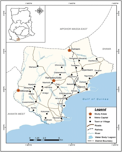
The numerous benefits derived from river bodies have attracted many people to live in places such as Eshiem, Kansawurodo and Whindo in the STMA (STMA Citation2013). These communities are very close to the Anankwari, Kansawura and the Whin rivers, respectively (Figure ). Flooding has almost become an annual event in the communities because excessive rainfalls cause the rivers to overflow their banks to people’s homes, but residents continue to live there (Aklorbortu Citation2011, STMA Citation2013). Despite this revelation, little is known about the coping strategies used by the residents in Eshiem, Kansawurodo and Whindo in the event of severe flooding. It is imperative to examine how people in these communities cope with flooding, so that, the findings can be factored into national policies and local strategies geared toward flood management. This article therefore assesses the coping strategies of households during flooding, using three communities in the STMA as a case study. The study provides useful information for flood management in the STMA and similar regions.
Figure 1. The STMA showing the study areas; Source: Cartographic Unit (Citation2013). Department of Geography and Regional Planning, University of Cape Coast, Ghana.
Study area
The STMA shares boundary with Ahanta West District to the west, Mpohor Wassa East to the north, Shama District Assembly to the east and the Gulf of Guinea to the south (Figure ). With a total land area of 49.78 km2, the STMA is the third largest metropolis in the country, after Accra and Kumasi. It has a population of 404,041 (STMA Citation2013). The metropolis is underlain by hard basement granites, gneisses and schists that are capped with faulted shale and sandstones. Its ground water has a relatively high salt content, while the water table is high. The topography is undulating with the central parts of Takoradi lying at an altitude of six meters below sea level (STMA Citation2013). These low lying areas are interspersed with ridges and hills that range from 30 meters to 60 meters above sea level. Kansawurodo, Anankwari and Whin are the major rivers which flow through the metropolis. The metropolis has a moist tropical climate (Acheampong Citation2009). The annual mean temperature and rainfall are 22 °C and 2350 mm, respectively. The area has a double maxima rainfall. The major rainy season occurs between March and July, while the minor which is usually of short duration but very copious, takes place between September and November (Ghana Districts Citation2006). The selected areas of the STMA for the present study are Eshiem, Kansawurodo and Whindo because of their proximity to the major rivers, which makes them vulnerable to recurrent flooding (Figure ). The National Disaster Management Organization (NADMO) ranks the three communities as highly prone to flooding. The communities are fourth class residential areas that are basically unplanned and traditional (STMA Citation2013).
Materials and methods
Mixed cross-sectional design method was adopted in the study. This method was used because of the heterogeneous nature of the targeted population, which included heads of households and some state institutions such as NADMO. Therefore, questionnaires were used to gather data from the heads of households, in-depth interview guides were used to gather data from members in some state institutions, while certain areas within the communities were photographed. The data covered the coping strategies used by the residents during flooding, as well as the responsive adjustments employed in the aftermath. The total populations of the communities (Eshiem, Kansawurodo and Whindo) were 1985, 4400 and 2107, respectively (STMA Citation2013). From a frame of 1377 heads of households, a sample size of 207 was scientifically determined for the quantitative aspect. Systematic sampling technique was used in selecting the heads of households. This technique required the calculation of sample intervals for each community (Table ). This was done by dividing the number of households (h) of each community by the community’s sample size (z). At each community, the first household was randomly selected and the sampling interval was used to select the subsequent heads of households. At Eshiem for example, after the random selection of the first head of household, every seventh head of household was considered as a respondent. This procedure was repeated until the required sample assigned to each community was obtained. The sample size of each community was obtained by dividing the population of the households by the entire household population (1377) of the three communities. The result was then multiplied by the sample size of 207 which is displayed in the following model:
Table 1. Sample size distribution for the selected communities.
In addition to the quantitative study, three representatives of the STMA, the Town and Country Planning Department (TCPD) and NADMO, as well as chiefs of the three communities formed the key informants for the in-depth interviews. Three field assistants reading Masters Programs were trained to help in the collection of data. The drafted questionnaire was pretested in order to check all uncertainties. Ten people were used for the pre-testing exercise at Kwaprow, a suburb of Cape Coast. The selection of Kwaprow was based on the fact that it lies adjacent to the Kakum River and also experiences flooding whenever it rains copiously. Permission was obtained from the STMA, the chiefs and heads of households before the commencement of the fieldwork. Introductory letters from the Department were presented to the chiefs and the institutional heads. Letters to the chiefs were accompanied by drinks as custom demands. After gathering the relevant data, the outcome was scrutinized to check out mistakes and the data were fed into the Statistical Product and Service Solution (version 16) software for analyses. Descriptive statistics in the form of frequencies and proportions were used to analyze the quantitative data as presented in cross tabulations and pie chart. The results from the in-depth interviews were categorized and described under themes (Table ). Respondents were made aware of their voluntary participation, while anonymity and confidentiality in the collection and reportage of the outcomes were ensured. One of the challenges encountered was getting some heads of households to participate in the survey. This difficulty stemmed from the fact that some heads of households attended work from Mondays to Saturdays. So, some of the data collection were done on Sundays when the majority were at home.
Results
Coping strategies to flooding
As shown in Table , the most common coping strategy used by the selected households was seeking temporary refuge (50%) from neighbors whose homes were relatively safe. Forty-four percent also transferred their important valuables such as electrical gadgets, clothing, mattresses and documents to friends and relatives who lived on higher ground. About a quarter of the inhabitants also cleaned gutters (26%) or built flood steps (25%) to prevent their homes from getting flooded. The least cited strategy was the elevation of sites before building. About one out of thirty-three respondents (3.0%) used this strategy which involved the raising of the surface above flood level with either laterite or stones before putting up houses. This strategy was a precautionary way of adapting to unexpected flooding (Table ).
Table 2. Community coping strategies to flooding.
The results further show that there were variations in the coping strategies adopted by residents of the three communities. Comparing the three communities, strategies such as elevating land before the building of houses and clearing of choked gutters were not seen at Eshiem and Whindo, although seven and 54 residents of Kansawurodo applied these methods respectively (Table ). As indicated in Table , all the nine flood adaptation strategies were employed at Kansawurodo compared with the other communities. Clearing of choked gutters was a common coping strategy used in the community because of the availability of numerous gutters. However, this strategy was assessed as ineffective because of poor waste disposal behavior within the community (Figures a and b). Eshiem (52%) was an outstanding community that practiced rebuilding of destroyed houses with cement, followed by Kansawurodo (25%) and Whindo (23%). Comparing the three communities, 19 percent of the respondents who built flood steps to cushion the effects of flooding were from Eshiem, whereas about 69 percent who used the same strategy were from Kansawurodo as illustrated in Figure .
Figure 2a. River Kansawura choked with refuse and weeds; Source: Fieldwork, 2013.
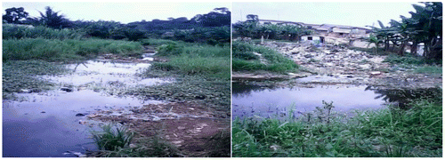
Figure 2b. Drainage channels in Kansawurodo choked with refuse, silt and weeds; Source: Fieldwork, 2013.
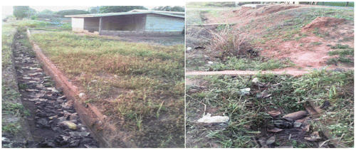
Figure 3. Flood steps used in Kansawurodo and Eshiem; Source: Fieldwork, 2013.
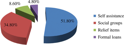
The sources of resources for flood management within households were also studied. Figure indicates that the commonest means by which residents recovered from flooding was self-assistance (52%), such as usage of personal savings to rehabilitate buildings. About 35 percent of flood victims said that friends and relatives (social groups) helped them to restore their losses, while less than a quarter (9%) resorted to relief items from churches and Non-Governmental Organizations (Figure ). About one out of twenty (5%) also sought loans from banks and credit unions to restore their losses.
Figure 4. Responsive adjustments to floods; Source: Fieldwork, 2013.
Institutional responses to flooding in the STMA
Results from Table show that TCPD, NADMO and STMA were the main institutions mandated to address flooding issues within the communities. The chiefs of the three communities also had roles to play in managing flooding. None of the institutions and chiefs admitted to ever selling lands to the residents along the river banks. The chiefs in particular, claimed that ownership of lands along the river banks is historical and occurred before they were born (Table ; Q. 1 and 7). When questioned about efforts made to help flood victims, representatives of the various institutions and the chiefs opined that NADMO is responsible for providing relief items to the victims, as well as announcing the dangers posed by an impending rainfall (Table ; Q. 2 9 and 10). However, it was discovered that the chiefs occasionally organized the community folks to remove waste materials from the rivers. The idea was to prevent an overflow of the rivers to the neighboring houses as the rainfall seasons approached. They also liaised with the Assembly to educate the public about the dangers of living in flood-prone areas (Table ; Q. 2 and 3). As indicated in the results, the institutions were aware of their roles and the policies that mandated them to operate within the STMA (Table , Q. 8, 13). However, they pointed out that there were political, financial and attitudinal factors that inhibited their efforts to properly manage flooding within the communities (Table , Q. 4, 5, 7, 12 and 13).
Table 3. Institutional responses to flooding.
Discussion
The various coping strategies used by the residents were meant to protect lives and properties as similarly established by the Water Resources Commission (Citation2011). Based on the findings, the coping strategies employed by the residents can be categorized into three areas, namely, reactive, preventive and recovery. The reactive strategies can be explained as the immediate responsive measures used by victims to reduce the effects of flooding. The recovery strategies were meant to reclaim destroyed properties and assets, while the preventive strategies were employed to avoid the recurrence of flooding in the future. The findings show that the main reactive strategies used in times of flooding were seeking for refuge in flood-free settlements and transferring valuables to friends and relatives. Thus, the idea was to protect lives and properties, then, think of recovery strategies afterwards. This finding is in line with a study conducted by Nyakundi et al. (Citation2010) which discovered that affected families in areas inclined to flooding usually vacate their homes and move to camps or homes of friends and relatives. Clearing of blocked gutters, construction of flood steps, elevation of land before building and placing valuables on shelves were the main preventive tactics employed by residents in flood-prone communities. Those affected by the flooding usually rebuilt their destroyed settlements with cement or placed sand bags in the flooded areas. This strategy corresponds with the coping mechanisms used by the people of Kalingalinga and Linda Compounds in Zambia (Simatele Citation2010).
With respect to the recovery strategies used by the flood victims, the majority recuperated using self-supporting strategies. Many used their personal savings to repair damages occurred after flooding, while few admitted that friends and relatives were consulted for assistance in the event of flooding. Some of the support received from friends and relatives included assistance in the packing of belongings, cleaning of houses after flooding and offering of informal loans/food items. Receipt of relief items such as: bags of rice, blankets, mattresses, mosquito nets and roofing sheets from churches and NGOs, as well as formal loans from banks and credit unions were not popular recovery strategies adopted by the residents, although a few admitted using such means. This echoes a similar study by Sakyi (Citation2013) which disclosed that only a few victims in the Pru District of Ghana received relief items from external sources after a flooding event. It was also discovered that collateral requirements and high interest rates prevented many flood victims from borrowing money from banks and credit unions to recover from their losses. This reflects on other studies in which poor households affected by flooding sometimes borrowed money and food from close associates instead of going for formal loans (Nuorteva Citation2009, Nyakundi et al. Citation2010).
One other revelation from the study was that the coping strategies used by the respondents varied by their places of residence. For instance, strategies such as elevating the land before rebuilding and clearing choked gutters were unseen at Eshiem and Whindo, although such strategies were adopted by the people of Kansawurodo. Rebuilding of structures with cement was more common among residents of Eshiem than the other communities. The implication is that, the strategies used within each community depended on the nature of land and available resources. This confirms the arguments of Fasona et al. (Citation2010) that due to variations in resources and vulnerability to flooding, adaptation requires place-specific strategies.
Although the various institutions supported the creation of drainage systems to allow the flow of water and the enforcement of building regulations especially in waterways, evacuation of the people at risk seems to be the ultimate panacea to the flooding problem. The mentality is to permanently prevent flooding from occurring, rather than using temporary reactive measures to cope with the flooding only to be faced with a similar problem in the next rainy season. However, the tentative politics of evacuating people from risky areas, coupled with inadequate resources to compensate for the losses was the main challenge. It needs to be mentioned that many residents were knowledgeable of the risk they faced, but continued to live in such unsafe areas because of land affordability, easy land attainability and the quest to preserve ancestral lands. Questions can therefore be asked about the effectiveness of state policies to restrict people from living in life-threatening areas. As mentioned earlier, the country has well documented policies such as the Blue Agenda, the National Water Policy of 2007 and the Environmental Sanitation Policy of 2010 to check buildings in unauthorized and dangerous places. However, gaps in the implementation of these policies have contributed greatly to the annual incidence of flooding in the communities. This gap emanates from the politics of giving a ‘human face’ when residents in risky areas need to be simply evacuated. The friction between government and people living in flood-prone areas as well as ‘weak’ implementation of the National Water Policy contributes to the flooding problem in the country. To curb the problem, this study recommends that the STMA, the TCPD and NADMO should intensify education to residents in the metropolis about the dangers associated with the construction of buildings along watercourses. The Waste Management Department should provide communal refuse containers at vantage positions for residents, to prevent people from disposing waste into the rivers and drains. The sensitization should be followed by a law enforcement system that punishes perpetrators. As a reactive solution, the Assembly should enlarge the drains to contain large volumes of water before the rainy seasons. The STMA and the TCPD should set up committees that will decide on issues relating to the acquisition of land permits in the metropolis. With this in place, land permits will be issued by the committees after thorough evaluation of lands. The Assembly in collaboration with the Security Agencies and other stakeholders should organize a demolition exercise in the metropolis after education and awareness campaigns against unlawful structures have been carried out. This should be done with compensation for the resettled people to avoid post-demolition discomforts.
Conclusions
As established in this study, flooding has debilitating effects on victims. Therefore, the implementation of measures aimed at reducing its impact on societies should not be ‘politicized’. Rather, the available policies and regulations should be well implemented, in order to save lives and properties, particularly in the wake of any impending disaster. It is conclusive that many coping strategies employed by victims deserve alterations. For instance, flood victims mainly coped with flooding by seeking refuge in others’ homes (50%) or transferring their valuables to them (44%). Others resorted to preventive strategies such as: construction of flood steps (25%), elevation of land before building (3%), clearing of blocked gutters (26%) and placing valuables on shelves (13%). Thus the majority of the flood victims used more reactive coping strategies than preventive, but such reactive measures are costly and sometimes ineffective. More efforts should be concentrated on devising preventive approaches to solving the flooding menace.
The study also shows that the type of coping strategies used by flood victims varied by geographic locations. Analyzing the findings carefully, the various stakeholders, including flood victims, contribute to the flooding menace. For example, though torrential and copious rains trigger flooding, some human activities such as dumping of refuse into river bodies greatly contribute to the problem. This could have been checked by proper enforcement of the Blue Agenda and the National Water Policy, which have been ‘softly’ implemented. The study therefore serves as a basis for further research and debate into the strategies used by households affected by flooding. Future studies can look into details, the barriers preventing the implementation of the existing policies on flooding. Research on the adaptation strategies to flooding in the Central Business District of the Sekondi-Takoradi Metropolis popularly known as Market Circle, which is gradually becoming another risky area will also be very timely. Such a study will bring to the fore how floods are affecting commercial activities in and around the Market Circle.
Acknowledgements
Special thanks go to the Heads of Sekondi-Takoradi Metropolitan Assembly, National Disaster Management Organization, Town and Country Planning and the chiefs of Eshiem, Kansawurodo and Whindo for their time and contributions to this study. We also acknowledge all contributing fieldworkers at the Department of Geography and Regional Planning in the University of Cape Coast, Ghana. Respondents cannot be left out of this acknowledgement as they did not hesitate to furnish responses for this paper. We say a big thanks to you.
References
- Acheampong, P.K., 2009. The Earth: Themes and Variations. Cape Coast, Ghana: University of Cape Coast Printing Press.
- Ahadzie, D.K., and Proverbs, D.G., 2011. Emerging issues in the management of floods in Ghana. International Journal of Safety and Security Engineering, 1 (2), 182–192.
- Aklorbortu, M.D., 2011. Floods take over Sekondi-Takoradi after heavy rains. Daily Graphic [online]. Available from: http://www.dailygraphic.com [Accessed 16 May 2013].
- Unit, Cartographic, 2013. The STMA showing the study areas, 1:5,000,000. Cape Coast, Ghana: University of Cape Coast.
- Fasona, M.J., Tadross, M., Abiodun, B.J., and Omojola, A.S., 2010. Climate change, terrestrial ecology imprints and adaptation options in semi-dry environments: A case of the Nigeria Savannah. Paper presented at the 2nd International Conference on Climate, Sustainability and Development in Semi-Arid Regions, Fortaleza-Ceará: ICID+18.
- Ghana Districts, 2006. Sekondi Takoradi Metropolitan: Climate and vegetation [online]. Available from: http://www.ghanadistricts.com [Accessed 16 May 2013].
- Ghana Statistical Service, 2005. 2000 Population and housing census of Ghana. Accra, Ghana: Ghana Statistical Service.
- Institute of Local Government Studies and International Water Management Institute, 2012. Community adaptation to flooding risk and vulnerability: Final report. Accra, Ghana: ILGS and IWMI.
- Inter-Parliamentary Union [IPU] and International Strategy for Disaster Reduction [ISDR], 2010. Disaster risk reduction: An instrument for achieving the Millennium Development Goals: Advocacy kit for parliamentarians [online]. Geneva: IPU. Available from: www.ipu.org/PDF/publications/drr-e.pdf [Accessed 16 May 2013].
- ISDR and World Bank, 2009. Disaster risk management programs for priority countries [online]. Available from: https://www.gfdrr.org/node/814 [Accessed 16 May 2013].
- Nuorteva, P., 2009. Resilience and Adaptation Strategies of Rural Livelihoods in Tonle Sap area. Master’s Thesis. Cambodia: Department of Geography, University of Helsinki.
- Nyakundi, H., Mogere, S., Mwanzo, I., and Yitambe, A., 2010. Community perceptions and responses to flood risks in Nyando District, Western Kenya. Journal of Disaster Risk Studies, 3 (1), 346–366.
- ProAct Network, 2008. Climate change adaptation and disaster risk reduction. Available from: http://proactnetwork.org/proactwebsite/media/download/PApolicies/drr_caa_policy_paper.pdf [Accessed 16 May 2013].
- Sakyi, F.K., 2013. A GIS-based flood risk mapping: A case study of Pru District in the Brong Ahafo Region of Ghana. Thesis (Masters): The Kwame Nkrumah University of Science and Technology.
- Sekondi-Takoradi Metropolitan Assembly [STMA], 2013. Medium-Term Development Plan. Sekondi, Ghana: STMA.
- Simatele, D.M., 2010. Climate change adaptation in Lusaka, Zambia: A case study of Kalingalinga and Linda Compounds. Working Paper Number 6. Lusaka, Zambia: The Global Urban Research Centre, The University of Manchester.
- Water Resources Commission, 2011. Climate Change Adaptation: A Primer for Water Conservation. Flood Risk Reduction and Irrigation Strategy for Northern Ghana. Accra, Ghana: WRC.
- Yeboah, L.A., and Aklorbortu, M.D., 2009. Rains cause more havoc in Accra, Takoradi. Daily Graphic, 7 July, p. 1.