Abstract
An engineering geological map at a scale of 1:10,000 of the Chiavari city area (Northern Italy) – a major tourist and economic attraction of the Ligurian East Riviera – is presented in this paper.
The municipality land shows an excellent geomorphological case-study of the well-known Ligurian coast: a floodplain, fairly wide and inhabited, formed by several floods of the two main rivers, a hill hinterland, reasonably inhabited, developed in marly limestones and sandy shales flysch and the coast – featuring cliffs and narrow pebbly beaches – deeply modified.
This map was compiled by combining available geological data with a new engineering geomorphological field survey and including geotechnical data which were obtained from studies carried out for town planning and building purposes.
On the basis of the critical review of the available lithostratigraphic data from drilling, as well as geotechnical and geophysical analyses carried out between 1981 and 2010 on the municipality land, an engineering geological map was compiled. Nine engineering geological units were established, based on their physical characterizations and geomechanical properties.
This paper presents an example of geocartography that could be applied to urban land planning for housing and construction of technical works; it also represents the base for geological hazard evaluation.
1. Introduction
Geoengineering maps are currently considered one of the most important work tools for land planning and management as well as for locating, building and upkeeping different types of structures (CitationDearman, 1974; CitationDearman, 1991; CitationIAEG, 1976; CitationRahn, 1996).
Thematic cartography usually shows the main items of environmental geology and suggests a land zonation in geomorphological and geotechnical terms by identifying different units according to the existing rock and soil geotechnical features (CitationFaccini, Piccazzo, Robbiano, & Roccati, 2008; CitationGrman, Waniekova, Petro, & Polascinova, 2002; CitationLozinska-Stepien, 1979). In these terms, engineering geological maps also have a major application in the dynamic response of structures to seismic activity (CitationRozos, Koukis, & Sabatakakis, 2006). The development in a GIS environment of such thematic cartography increases its potential as a user-friendly approach (CitationPasotti, 2003); at the same time it ensures a constant updating through the input of new surveys data.
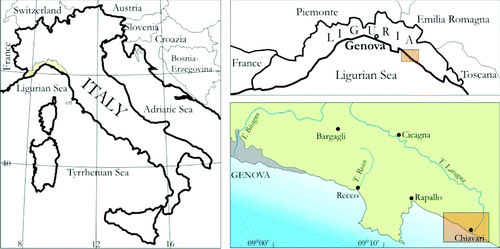
This work presents the engineering geological map case of the town of Chiavari, a major tourist site on the Ligurian East Riviera (). The municipality land shows typical geomorphological features of the Ligurian coast: a floodplain, fairly wide and inhabited, formed by several floods of the two main rivers, a hill hinterland, reasonably inhabited, formed in heterogeneous rock masses such as flysch and the coast, featuring seacliffs and narrow pebbly beaches that have been deeply modified.
Figure 1. Location of the study area (Italy, Liguria, Riviera Ligure).
A critical review of the available lithostratigraphic data from drilling, as well as geotechnical and geophysical analyses carried out between 1981 and 2010 on the municipality land, enabled the description of the soils that lay a few metres from the surface under the effect of anthropic modification, and feature homogeneous geomechanical behaviour and physical state (geoengineering units).
In order to define engineering geological units, all private and public data from the surveys, in situ geotechnical tests and geophysical prospecting conducted on the building sites were compiled in a database.
2. Geological outlines
The hilly sector of the Chiavari municipality reaches a highest elevation of 529 m a.s.l. at Mt. Anchetta and is characterized from W toward E by the geological formations of Mt. Antola Limestones, Manganese rich Shales and ‘Palombini’ Clays. These are all heterogeneous rock masses such as Flysch: Mt. Antola Limestones, which are located in the western part of the municipality land between the right bank of the Rupinaro Stream and the boundary with the Zoagli municipality, are characterized by a rhythmic sequence of mainly marly limestones and subordinately siltstone shales and slates (CitationCorsi, Elter, & Giammarino, 2001). The Manganese rich Shales spread over the central sector between the Rupinaro Stream axis to the west and the hamlets of Rì Alto and Rì Basso to the east: these feature dark shales with thin interlayers of slates, siltstones, calcarenites. ‘Palombini’ Clays lie in the eastern sector of the municipality land; these are generally found on the left bank of the Entella Stream and are composed of dark shales with limestone interlayers (CitationVan Wamel, 1987; CitationVan Zupthen, Van Wamel, & Bons, 1985).
At the outcrop-scale the bedding shows a dip that varies according to the tectonic deformations; all the formations described above are multi-deformed with a series of deformation phases. At least two sets of main tectonic discontinuities can be observed on this area. The coastline as well as primary and secondary water courses follow these discontinuities. The first is the most ancient and lies in a NW-SE direction, while the second has an approximate orthogonal direction NE-SW. The area landforms are created by gravity, running waters, wave action and anthropic activity. A few very large active complex landslides, which are frequently found within the area of deep seated gravitational slope deformations, feature in the Chiavari area, that is, those located under the Madonna delle Grazie Sanctuary in the western part of the town (CitationBrandolini, Faccini, Robbiano, & Terranova, 2009). Other very large landslides can be observed along Rio Campodonico at Rì Alto and on the right bank of the Entella Stream.
Alluvial deposits characterize the Rupinaro Stream plain to the W and the Entella Stream to the E. The Entella Stream is one of the longest in Liguria with a catchment of almost 400 km2.
Alluvial fans can be found at the end of primary and secondary valleys although they cannot be easily observed because of the overlying urbanization.
Coastal depositional and erosive landforms can be identified. There are wide beaches typical of the Chiavari coastline between the mouth of the Entella Stream to the E and the hamlet Gli Scogli to the W, where the rocky coast begins. Beaches have been modified by anthropic action particularly over the last 50 years and are subject to continuous accretion due to the construction of the tourist harbour.
The high rocky coast occupies the western part of the municipality land. Seacliffs display evidence of instabilities that are a function of the rock masses' characteristics, as well the exposure to wave action from the SW. The seacliffs frequently develop into very large active landslides.
Man-made work is scattered over the Chiavari area; mainly fill material from the marina along the seaside walk, the cemetery, railway and highway areas.
3. Methods
The method that has been followed here consists of preliminary bibliographic and map research to inventory applied geological and geomorphological material and land planning data, followed by an evaluation of geotechnical studies which were conducted for building and environmental protection purposes in the municipality.
The geological data base was obtained through the collection of drill surveys and on-site geotechnical tests carried out over the last 30 years in the municipal territory for various purposes. These are mainly dynamic penetrometer tests, conducted by different field instruments, boreholes with continuous core sampling, water wells, stratigraphical digs and seismic refraction surveys. In several cases laboratory tests were carried out on soil samples taken during the drilling activities, for both soil classification purposes and strength or deformability determination. Overall more than 150 building sites were listed in the inventory and more than 500 surveys were carried out on these sites.
The bibliographic information was integrated with a detailed geological field survey, preceded by photo-interpretation analysis using the Ligurian Region aerial photos that were available at a scale of 1:13,000.
The method used for geomaterials and engineering geological features is derived from the Unified Soil Classification System, British Soil Classification System classifications (CitationAgili, Cecchi, Coli, Pini, & Rubellini, 2005; CitationBell, 1998) and taking into account the more recent geotechnical guidelines of Eurocode 7 (CitationNorbury, 2010; CitationScarpato, 2011), with a primary division between coarse and fine soils ().
Table 1. The main lithological types, primarily used as foundation ground in the Chiavari city urban area (Dr = relative density, φ' = effective friction angle, LL = liquid limit, PI = plastix index, e0= void ratio, δd = dry bulk density, δb = bulk density, Su = undrained shear strength, ω = water content, OCR = over consolidation ratio, c' = effective cohesion; C0 = uniaxial compressive strength, RQD = rock quality designation, GSI = geological strength index).
Bedrock characterization was developed also by following the Geological Strength Index (CitationMarinos & Hoek, 2000), which is based on the Rock Mass Rating (CitationBieniawski, 1989).
The map shows the first significant soil layer and is representative of the main area; while interpolating the various logs, preference was given to the average area interpretation, occasionally ignoring discrepancies from a single log. The interpretation took into account the geomorphological setting of the previous anthropic modifications, which were particularly extensive during the late twentieth century and during the urban development of the town of Chiavari ().
Figure 2. Chiavari in 1758 (from Matteo Vinzoni, Pianta delle due riviere della Serenissima Repubblica di Genova divise né Commissariati di Sanità).
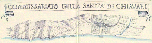
Figure 3. Chiavari 1816–1827 (from Istituto Geografico Militare, Corpo di Stato Maggiore, territorio compreso tra Genova, Spezia e il confine col Granducato di Parma, Foglio 61).
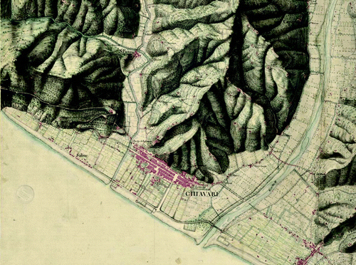
Figure 4. Chiavari 1936–1937 (from Istituto Geografico Militare Italiano, Tavolette 94 I NO Chiavari, 94 I NE Sestri Levante).
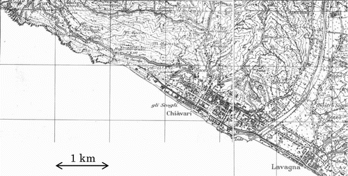
Figure 5. Chiavari in 1992 (from Regione Liguria, Carta Tecnica Regionale, Tavolette 231.1 Rapallo, 232.4 Lavagna).
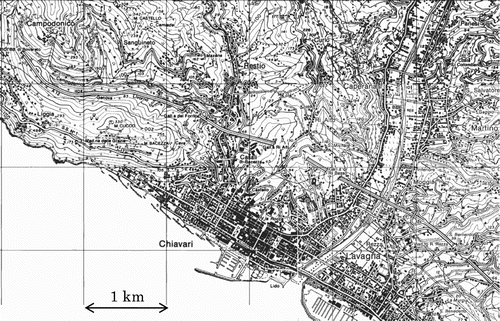
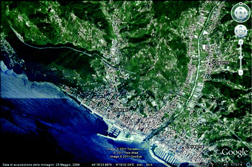
Figure 6. Chiavari at 2009 (from Google Earth).
4. Main results
The engineering geological map of Chiavari municipality divides the area into homogeneous sectors in terms of mechanical behaviour, parameters of composition, cementation degree, bedding type, fracture and alteration level. Drill and hydrogeological data also enabled the description of a possible bedrock trend when it was buried under sediments.
A primary distinction of the municipality land was made on the basis of the geomorphological setting it belonged to: flood plain and hillslope environment.
Alluvial soils (fluvial, marine) were first distinguished based on the grain-size analysis: coarse and fine (cohesive) soils; then gravelly soils were distinguished from sandy soils partly according to the fine fraction.
The well graded or poorly graded gravel, with subordinate sand and little or no fines (< 5%), is almost exclusively observed in the present-day riverbed of the Entella Stream. The graded gravel and sands, with significant fines (frequently 5%–10%), are found at the confluence of secondary streams into the Entella and Rupinaro Streams as well as the Rio Campodonico valley floor, this river has a drainage axis parallel to the coast.
Alluvial deposits of fluvial origin are composed of very silty sand, gravelly silt and sandy silt and are found in both the Entella and Rupinaro Streams valley floors. These are interposed between the deposits described above at the toe of the hillslope. The land clearly of marine origin are composed of well-graded or poorly graded sand, with subordinate gravel and little or no fines (< 5%) representing the coastal sector strictu sensu.
Cohesive soils, which are composed of clayey silt and inorganic silty clay of low to medium plasticity, with a granular fraction (sand or gravel) usually between 5% and 10%, locally major or minor, feature in low energy fluvial environments. Among these, a plain along the right bank of the Entella Stream where the river flowed over the past centuries and, primarily, the majority of the flood plain of the Rupinaro Stream. This was apparently characterized by the deposition of fines and the morphological setting of the bedrock indicates the presence of an incised buried valley.
With respect to the hills, a distinction was made between bedrock and superficial covers of identifiable thickness. Bedrock was distinguished mainly according to its lithological type and consequentially provided a range of Geological Strength Index values. Marly limestones, marls and calcarenites (Flysch of Mt. Antola), shales with limestone and fine sandstone interlayers as well as slates were identified (Shales).
Embankments comprised coarse soil with relative density from loose to dense, frequently mixed with heterogeneous material (pitch, bricks, etc.). It is mapped where it is developed as a continuous layer more than 2-m thick.
5. Conclusions
The large-scale engineering geological map of Chiavari shows the main items of applied geology and suggests a land zonation mainly in geotechnical terms by identifying different units according to the existing rock and soil geotechnical features. This map was based on a combination of conventional geological mapping techniques. Its geotechnical derivative information is considered to be useful for a preliminary, pre-site characterization planning level; in these terms geo-engineering maps are a major application also for seismic microzonation.
Data management in a GIS environment enabled us to develop a cartography tool that can be constantly updated and improved following the results of new studies (e.g., surveys, drillings, geophysical prospecting).
Software
Corel Draw 13.0 was used for compiling the engineering geological map; the digital terrain model was produced on the basis of contour lines drawn on the technical regional map, processed using Surfer 8 (Golden Software Inc.).
tjom_a_668756_sup_24685560.pdf
Download PDF (6.9 MB)Acknowledgement
We thank Dr. Randall C. Orndorff, Prof. Jim Griffiths and Dr. Paul Hearn for their constructive suggestions and comments.
Related Research Data
References
- Agili , F. , Cecchi , M. , Coli , M. , Pini , G. and Rubellini , P. 2005 . Firenze - Carta litotecnica (Tavv, 1–4), Maps printed by S.EL.CA, Florence
- Bell , F. G. 1998 . Environmental geology principles and practice , Oxford: Blackwell Science .
- Bieniawski , Z. T. 1989 . Engineering rock mass classifications , New York, NY : Wiley .
- Brandolini , P. , Faccini , F. , Robbiano , A. and Terranova , R. 2009 . Slope instability on rocky coast: A case study of Le Grazie landslides (Eastern Liguria, northern Italy) . The Geological Society , 322 : 143 – 154 .
- Corsi , B. , Elter , F. M. and Giammarino , S. 2001 . Structural fabric of the Antola unit (Riviera di Levante, Italy) and implications for its Alpine versus Apennine origin . Ofioliti , 26 ( 1 ) : 1 – 8 .
- Dearman , W. R. 1974 . Presentation of information on engineering geological maps and plans . Quarterly Journal of Engineering Geology and Hydrogeology , 7 : 317 – 320 .
- Dearman , W. R. 1991 . Engineering Geology Mapping , Oxford : Butterworth & Heinemann .
- Faccini , F. , Piccazzo , M. , Robbiano , R. and Roccati , A. 2008 . Applied geomorphological map of the Portofino Municipal territory (Italy) . Journal of Maps , 4 : 451 – 462 .
- Grman , D. , Waniekova , D. , Petro , L. and Polascinova , E. Engineering geological maps of the Tibreg region. Geologica Carpathica, Special Issue, 53 . Proceedings of XVII Congress of Carpathian-Balkan Geological Association . September 1–4 2002 , Bratislava .
- IAEG Commission. (1976). Engineering Geological maps: A guide to their preparation. UNESCO. Edited by W.E. Dearman. UNESCO Earth Science Publication No. 15. Paris, France, 79 p.
- Lozinska-Stepien , H. 1979 . Engineering geological maps at a scale 1:25 000 for regional planning purposes . Bulletin of Engineering Geology and the Environment , 19 ( 1 ) : 69 – 72 .
- Marinos , P. and Hoek , E. 2000 . “ GSI ” . In A geologically friendly tool for rock mass strength estimation , Melbourne : GeoEng 200 .
- Norbury , D. 2010 . Soil and rock description in engineering practice , Caithness, Scotland , , UK : Whittles Publishing .
- Pasotti , J. GIS-based engineering geological map prototype for the Swiss Geological Atlas . 4th European Congress on Regional Geoscientific Cartography and Information Systems, Proceedings . Bologna , Italy.
- Rahn , P. H. 1996 . Engineering geology , New York, NY: Prentice-Hall .
- Rozos, D., Koukis, G., & Sabatakakis, N. (2006). Large-scale engineering geological map of the Patras city wider area, Greece. The Geological Society of London, IAEG, 241. Retrieved from http://iaeg2006.geolsoc.org.uk/cd/PAPERS/IAEG_241.PDF
- Scarpato , D. J. 2011 . Soil and rock description in engineering practice . Environmental & Engineering Geoscience , 17 ( 3 ) 309 – 311 .
- Van Wamel , W. A. 1987 . On the tectonics of the Ligurian Apennines (northern Italy) . Tectonophysics , 142 : 87 – 98 .
- Van Zupthen , A. C.A. , Van Wamel , W. A. and Bons , A. J. 1985 . The structure of the Val Lavagna Nappe in the region of the Monte Ramaceto and Val Graveglia (Ligurian Apennines, Italy) . Geologie en Mijnbouw , 64 : 373 – 384 .