Abstract
This work presents a morphotectonic map of the Osento River basin, located in the southern Abruzzi area, Italy, flowing on the eastern Apennines piedmont into the Adriatic coast. The piedmont area developed in a marine environment from the Pliocene to the early Pleistocene resulting in the deposition of a clayey-sandy sequence. Afterwards, regional uplift with NE tilting, led to the deposition of a regressive conglomeratic sequence, as the area evolved into a continental environment. Since the middle Pleistocene the landscape developed by regional uplift, local tectonics and geomorphic processes, mostly through fluvial and slope modification.
The morphotectonic map of the Osento River basin is the result of a drainage basin scale geomorphological analysis and incorporates four main sections: orography and hydrography section (upper left on the map); main morphotectonic map section (central and right on the map); Quaternary fluvial deposits and terraces section (central-left on the map); longitudinal morphotectonic profile section (lower part of the map).
The map presented in this work provides the basis for recognition of morphotectonic features at basin scale, detection of tectonic control on landscape, and reconstruction of paleo-landscapes. It provides a contribution to define the main phases of post orogenic landscape evolution of the piedmont area of the Apennines chain, resulting from the link of alternating morphotectonics and surface processes, due to uplift processes, local tectonics and alternating slope and fluvial processes.
1. Introduction
A drainage basin scale geomorphological analysis in the Adriatic piedmont of Central Apennines (Italy) enabled the creation of a morphotectonic map of the Osento River basin (Abruzzo, Italy) (scale 1:30,000) within a geographical information system (GIS) environment by means of: digital elevation model (DEM)- and map-based cartographic analysis and morphometry of orography and hydrography (raster and vector data 1:25,000–1:10,000 scale, 5-m grid DEM), photogeology analysis (1:33,000 scale), Quaternary continental deposits, fluvial terraces and morphostructural field mapping (1:10,000 scale), morphotectonic profiles that couple landform, deposits and terraces.
The morphotectonic map of the Osento River basin (Abruzzo, Italy) incorporates four main sections:
| 1. | orography and hydrography section (upper right on the Map); | ||||
| 2. | main morphotectonic map section (central and left on the Map); | ||||
| 3. | quaternary fluvial deposits and terraces section (central-right on the Map); | ||||
| 4. | longitudinal morphotectonic profile section (lower on the Map). | ||||
2. The study area
The Osento River valley is located in the Apennines piedmont, in the southeastern Abruzzi area and lies in a complex geological framework between the Central Apennines to the west and the Adriatic coast to the east (, b, ). This area is characterised by a cuesta, mesa and plateau relief at a moderate elevation, sloping from SW to NE, from >500 m a.s.l. to sea level.
Figure 1. (a) Location map of the Osento River basin (light blue area indicates the basin location, dashed lines indicates administrative Provinces). (b) Location of the Osento River within the piedmont and hilly area of the Abruzzo region (3D view from south, 90 m DEM, NASA-SRTM).
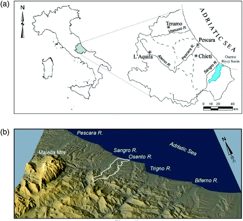
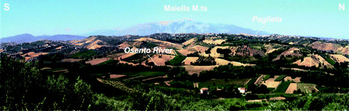
Figure 2. Panoramic view of the Osento River valley.
The Central Apennines are an asymmetric mountain range characterised by alternating ridges (up to 2900 m high; Gran Sasso massif, 2912 m; Maiella massif, 2793 m) and valleys with a NW-SE to N-S trend and by wide intermontane basins. The Abruzzi Apennines are dominated by a general imbricate fan geometry formed by a thick Mesozoic and Cenozoic carbonate platform and pelagic basin pre-orogenic sequences, overlain by pelitic and arenaceous Miocene foredeep syn-orogenic sequences. To the SE, across the Sangro basin, these structures are buried under a pile of thrusted nappes composed of Mesozoic and Cenozoic pelagic clays and carbonate pre-orogenic sequences that were subject to major NE transport (CitationCarminati & Doglioni, 2005; CitationParotto & Praturlon, 2004; CitationPatacca & Scandone, 2007). Since the late Pliocene the Apennines were affected by differential uplift and by extensional tectonics (CitationCavinato & De Celles, 1999; CitationD'Agostino, Jackson, Dramis, & Funiciello, 2001; CitationD'Alessandro, Miccadei, & Piacentini, 2003; CitationAscione, Cinque, Miccadei, Villani, & Berti, 2008).
An abrupt morphologic boundary separates the Apennines from the Adriatic piedmont, which develops cuestas, mesas and plateau landscapes, that slope from approximately 1000 m a.s.l. to less than one hundred metres. Along the coast main rivers flow along wide floodplains with SW–NE trend. In the piedmont area, gently folded middle Pliocene to lower Pleistocene late-orogenic clayey-sandy marine sediments of the Adriatic basin unconformably overlie syn-orogenic foredeep arenaceous and pelitic Miocene–lower Pliocene sequences and thrusted preorogenic clayey and carbonate pelagic sequences. In the lower Pleistocene a sandy and conglomeratic sequence recorded a regressive phase with a gradual transition from a marine environment to a beach and, subsequently, a continental one (CitationCantalamessa & Di Celma, 2004). The present structural setting is characterised by a wide homocline gently dipping northeast, affected by fractures and low displacement faults, as a response to Pleistocene uplift and local tectonics. The Pleistocene landscape of the Adriatic piedmont is shaped mainly by fluvial and slope processes.
A sequence of post-orogenic Quaternary continental deposits is formed on the piedmont immediately after its emergence, since middle Pleistocene, mainly consisting of alluvial fan and fluvial deposits. These are set in a sequence of four main levels of terraces, where age is correlated with climatic oscillation as confirmed by many chronological constraints and ranges from middle Pleistocene to late middle Pleistocene, late Pleistocene, and the Holocene (CitationCalderoni, Nesci, & Savelli, 1991; CitationColtorti, Consoli, Dramis, Gentili, & Pambianchi, 1991; CitationD'Alessandro et al., 2008; CitationDemangeot, 1965; CitationDi Celma, Farabollini, & Moscatelli, 2000; CitationFarabollini, 1999; CitationISPRA, 2011; CitationNesci, Savelli, Calderoni, Elmi, & Veneri, 1995).
3. Methods
A drainage basin scale geomorphological analysis enabled the creation of the morphotectonic map of the Osento River basin presented in this work, by means of: cartographic analysis and morphometry of orography and hydrography (raster and vector data 1:25,000–1:10,000 scale, 5 m grid DEM), photogeology analysis (1:33,000 scale), Quaternary continental deposits and morphostructural field mapping (1:10,000 scale), and morphotectonic profile drawing (Figure 3).
Topographic data are in vector (1:10,000–1:5000 scale) and in raster (1:25,000 scale) format and were provided by Struttura Speciale di Supporto Sistema Informativo Regionale of Abruzzo Region (http://www.regione.abruzzo.it/xcartografia/). Main topographic data provided are the Regional Topographic Map (1:25,000 scale, raster) and Digital Regional Technical Map (1:5000 scale, vector). A 5 m cell DEM was processed from the 1:5,000 scale vector map.
Orographic analysis is based on the 5 m DEM. Slope analysis, energy of relief analysis (elevation range per unit area, 1 km2) and hypsometric analysis were carried out.
Hydrographic analysis is based on the 5 m DEM and 1:25,000-scale topographic map. Longitudinal profile, drainage density, azimuth of the drainage network, patterns and hydrographic parameters were analysed (bifurcation parameters, hierarchic parameters, areal parameters, etc.; CitationAvena, Giuliano, & Lupia Palmieri, 1967; Capolongo, Cecaro, Giano, Lazzari, & Schiattarella, 2005; CitationCiccacci, Fredi, Lupia Palmieri, & Salvini, 1986; CitationKeller & Printer, 1996; CitationMiller, 1953; CitationSchumm, 1956; CitationStrahler, 1957).
Photogeological analysis was performed for the Osento River basin on 1:33,000-scale aerial photos (CitationAbruzzo Region Flight, 1987) for preliminarily mapping of major landforms (tectonic and structural landforms, fluvial landforms, slope landforms).
Morphostructural field mapping (1:10,000 scale) was carried out in spring and summer 2008. The field mapping investigated bedrock, Quaternary continental deposits, main tectonic elements and morphotectonic elements (ridges, slopes, valley, hydrography landforms and fluvial terraces) (CitationAmbrosetti et al., 1987; CitationBigi et al., 1996; CitationBull, 2007; CitationCentamore, Ciccacci, Del Monte, Fredi, & Lupia Palmieri, 1996; CitationCiccacci et al., 1986; CitationD'Alessandro, Miccadei, & Piacentini, 2008; CitationDella Seta et al., 2008; CitationENEL, 1981; CitationLupia Palmieri et al., 1996; CitationMiccadei, Mascioli, & Piacentini, 2011; CitationMolin, Pazzaglia, & Dramis, 2004; CitationPanizza & Castaldini, 1987; CitationPicotti, Ponza, & Pazzaglia, 2009; CitationWegmann & Pazzaglia, 2009).
The field mapping integrated with photogeology analysis led to the creation of the main maps (morphotectonic map and Quaternary fluvial deposits and terraces map) and transversal morpho-lithostratigraphic profiles (vertical scale 1:2,500–horizontal scale 1:20,000) and longitudinal morphotectonic profile (vertical scale 1:5000–horizontal scale 1:50,000).
4. Results
4.1. Orography and hydrography
The basin of the Osento River reaches its maximum altitude at Monte Pallano 1020 m a.s.l. (SW side). The present drainage basin area is about 127 km2 and its mean elevation is 247 m a.s.l. The coastal area in this sector is restricted to a very narrow beach edging alluvial plain or cliffs. Almost the whole extension (94%) is at an altitude ≤ 600 m a.s.l., the remaining 6% is at 600–1020 m a.s.l.. The average slope is 11°, the highest values (>60°) are in the upper part of the basin along the main scarps.
The longitudinal profile has a concave shape, with a length of 37 km with 18.54 m/km average gradient (θ). The high reach has a SW–NE trend (length 9 km, gradient 15–50 m/km); the middle reach has N–S trend (length of 23 km, gradient (∼10 m/km); the lower reach has E–W trend (length 6 km, gradient 0–5 m/km). The main tributaries are on the left NW side (Torrente Ciripolle, Fosso Boragna, Fosso Malatesta).
The Hypsometric Integral (CitationStrahler, 1957) for the entire basin is 0.24 and the curve shows a concave convex shape. The Energy Relief (Er) in the Osento River basin ranges between 0 m and 350 m.
Hydrographic parameters are typical of a basin on non-permeable rocks with high runoff, particularly the SW sector (drainage density D, high up to 8 km/km2). The drainage network is well developed (maximum hierarchical order 6), but not well organised, with moderately high bifurcation parameters (Rb, Rbd, R) and hierarchic anomaly parameters (Δa, ga). This suggests that different types of processes have induced the drainage basin incision: mostly fluvial in the NE sector with lower slopes and energy relief on more permeable conglomerate, sand and shale, landslides and soil erosion processes in the SW sector with higher slopes and energy relief on less permeable shale.
The areal hydrographic parameters outline a symmetrical (AF) and very elongated basin (F, Rc, Re) typical of uplifting piedmont.
Drainage patterns are different within the basin: mostly trellis in the NE part, with a sector of parallel pattern; dendritic in the SW part, with two anomalous areas of radial (SE) and annular (NW) pattern. The rose diagrams show the drainage preferential trends for the hierarchic orders from first to sixth: E-W trend is present on all the orders; N–S mostly on first to third order; NW–SE on first to fourth order; SW–NE is present mostly on the main streams (3rd, 5th, 6th order). This suggests a control of tectonics (major joints or low displacement faults) in the drainage development.
4.2. The main morphotectonic map
Lithology
The lithology units are briefly described with some details not included in the map; for lithological features see the map legend.
Pre orogenic marine deposits Clays (AS)
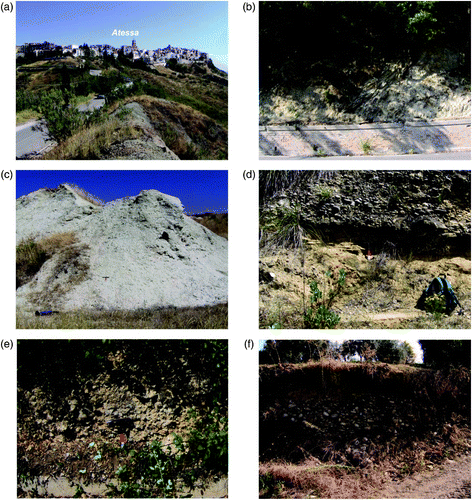
This unit outcrops in the SW sector of the basin from Tornareccio to Atessa Town (). Upper and lower stratigraphic limits are not visible, due to their tectonic nature; locally the upper limit with SASP is an erosional unconformity. Due also to an extensive cover of colluvial deposits, the overall thickness of this unit can only be estimated as several hundred metres. The age is Oligocene-Miocene and the unit is referable to ‘Argille Varicolori’ auctorum (CitationPatacca & Scandone 2007; CitationVezzani & Ghisetti, 1998).
Figure 3. Methods for the creation of the morphotectonic map of the Osento River basin.
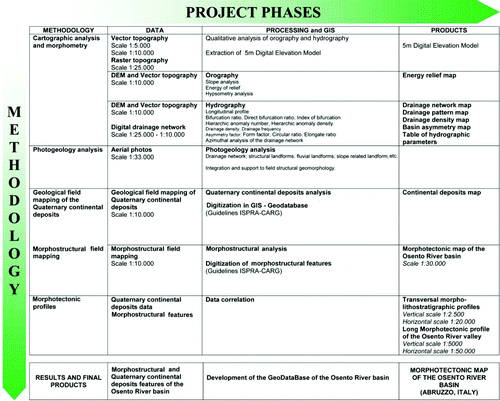
Figure 4. Lithological units outcropsing in the Osento river basin. (a) Clays (AS), near Atessa; (b) Limestone and marl limestone (CAM), near Tornareccio; (c) Pili sandy shale (SASP); (d) Masseria Mucci sands and gravels (SSCM); (e) Paglieta gravels (GP); (f) Masseria Mancini gravels (GM).
Limestones and marly limestones (CAM)
This unit outcrops in the SW sector of the basin from Monte Pallano and La Torretta to Tornareccio (). Upper and lower stratigraphic limits are not visible, due to their tectonic nature. The thickness is variable up to 400 m. The age is late Miocene and the unit is referable to Formazione di Tufillo p.p. Auctorum (CitationVezzani & Ghisetti, 1998; CitationSelli, 1962).
Syn-late orogenic marine depositsPili sandy shales (SASP)
This unit outcrops throughout the basin from Atessa to the coast (). The lower limit is an unconformity over preorogenic units, while the upper one is a stratigraphic contact with SSCM. The thickness is variable up to 200 m (CitationISPRA, 2010). The unit is referable to late Pliocene and early Pleistocene marine succession (Depositi indifferenziati del Pliocene, lower part, CitationPatacca & Scandone, 2007; Formazione di Mutignano sandy shale association, CitationISPRA, 2010).
Masseria Mucci sands and conglomerates (SSCM)
This unit outcrops at the hilltops of the NE part of the basin (). The lower limit is a stratigraphic contact with SASP; the upper limit is the partly eroded depositional surface, reworked and covered by eluvial deposits. The thickness is up to 30 m. The unit is referable to Formazione di Mutignano (FMTc, FMTd) and the age is early Pleistocene (CitationISPRA, 2010).
Post orogenic continental deposits Paglieta gravels (GP)
This unit outcrop at high elevation on the NW side or the middle part of the basin near Paglieta (). The overall thickness is not detectable, due to the alteration of the top surface, but is estimated to be around 5–10 m. The age is late middle Pleistocene, and the unit is possibly referable to sintema di Catignano (CitationD'Alessandro et al., 2008; CitationISPRA, 2010).
Masseria Mancini gravels (GM)
This unit outcrops in the middle–lower reach of the Osento River always on the left NW side of the valley. It is formed by fluvial gravel deposits, with heterometric (size 1–25 cm), polygenic (limestone and grey-black chert) pebbles and rare sandstone cobbles, clast supported with sandy-silty matrix (). The thickness is 5–15 m. The age is late Pleistocene and the unit is possibly referable to sintema di Valle Maielama (CitationD'Alessandro et al., 2008; CitationISPRA, 2010).
Capriccio gravels (GC)
This unit outcrops throughout the basin from Atessa to the Adriatic Sea. It is formed by fluvial gravel, sand and clay deposits, arranged in horizons and lenses with low angle cross stratification or parallel stratification. Gravel is composed of heterometric (size 1–30 cm), polygenic (limestone and grey-black chert) pebbles and cobbles, matrix- or clast-supported, with rare sandstone cobbles. The thickness is 5–10 m. The age is late Pleistocene, and the unit is possibly referable to sintema di Valle Maielama (CitationD'Alessandro et al., 2008; CitationISPRA, 2010).
Holocene deposits
These deposits are composed of four units: Eluvial deposits (olo b6 ) outcropping throughout the basin on flat and gentle sloping tops of hills; Colluvial deposits (olo b2 ) outcropping throughout the basin particularly at the base of slopes and within concave and flat bottom valleys; Fluvial deposits (olo b ) outcropping along the modern alluvial plain of the Osento River and main tributary streams; Landslide deposits (olo a1 ) outcropping on the main slopes within the basin (mostly in SW sector and NE sectors).
Morphotectonic elements
Morphotectonic elements are categorised as ridges, slopes, valley and hydrography ().
Table 1. Morphotectonic elements of the Osento River basin (see the map legend or section 4.2 for lithologic labels and descriptions).
Ridges
Mapped elements are: saddles and cuestas.
Minor saddles are widespread within the basin mostly with E–W and NW–SE trends, while a single main saddle is mapped in the NW side of the basin. It is E–W striking, along the drainage divide with Sangro River basin, and it is aligned with the lower E–W reach of the Osento River.
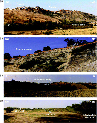
A main cuesta landform characterises the Atessa hill in the SW sector of the basin (), due to some tens of meters thick sandstone at the base of the Pili sandy shales unit (SASP) lying on the clays unit (AS). It has WNW–ESE trend, with SSW facing escarpment ().
Figure 5. Morphotectonic elements in the Osento River basin. (a) Atessa, escarpment of the cuesta located in the SW sector of the basin; (b) Structural scarp in the NE sector of the basin; (c) Asymmetric valley near Paglieta; (d) Fluvial erosion scarps with terrace fluvial deposits in the middle sector of the basin.
Slopes
Mapped elements are structural scarps and structural surfaces.
A very extensive structural scarp bounds the northern side of the basin in the lower E–W reach. Two minor structural scarps are in the southern side. The scarps are connected to selective erosion of SSCM overlying SASP.
A structural surface, located in the NE sector of the basin corresponds to the top of SSCM due to the well cemented conglomerates on top of the unit. The surface is partly eroded and covered by eluvial deposits. It corresponds to the top surface of the syn-lateorogenic succession and at which the marine sedimentation ends in the area.
Valleys
Mapped elements are: asymmetric valleys, V shape valleys, concave valleys, flat-bottom valleys, beheaded valleys, and hanging valleys.
Asymmetrical valleys are located mostly in the NW side of the basin (), with SW– NE and NW–SE and a steeper northern side. They occur on SASP mostly due to the low angle NE dipping attitude.
V shape valleys are widespread over the basin, mostly on the lower part of tributary streams of the Osento River (2nd–3rd order) and occur on SASP. The orientations are SW–NE, ENE–WSW, and locally N–S (eastern side of the basin) or WNW–ESE (NW side of the basin) and in most cases are on rectilinear fluvial segments..
Concave valleys are widespread on the NW side of the basin, near Paglieta, mostly on the first-order segments of the drainage network. They are mostly on SASP covered by colluvial deposits (olob2).
The flat bottom valleys have, in most cases, the same distribution as the concave valleys, and show WSW–ENE to SW–NE trend.
A single hanging valley is mapped on the eastern side of the basin, with a N–S trend.
Several beheaded valleys are located in the central sector of the basin, along the NW drainage divide with the Sangro River or locally along the SE divide. They are on SSCM and on SASP. The orientation is SW–NE or NW–SE. Their distribution suggests a strong rearrangement of the outer part of the drainage network, particularly in the NW side, due to the drainage evolution of the neighbouring basins (Sangro River).
The distribution of these features suggests that, within the upper part of the valleys, colluvial deposition is prevailing while in the lower part drainage incision dominates.
Hydrography
Mapped elements are: fluvial erosion scarps, rectilinear fluvial segments, river bends, 90° confluences, and counterflow confluences.
Fluvial erosion scarps are located all along the Osento valley. Recent scarps are along the modern channel, while ancient and partly smoothed scarps correspond to three levels of fluvial terrace scarps edging the top surface of middle-upper Pleistocene fluvial deposit (GP; GM; GC) at different elevations above the modern channel ().
Several rectilinear fluvial segments are mapped throughout the basin and in many cases correspond to V shape valleys. More than 70 landforms show mostly SW–NE or ENE–WSW (), particularly on the eastern side of the basin.
Several single and double bends are located in the basin, mostly with the same orientations of rectilinear segments ().
Ninety-degree confluences are both within the tributary valleys (T. Ciripolle) and at the junction of tributary valleys to the main river (left side), mostly with NW–SE and E–W trends ().
Counterflow confluences are located mainly in the lower E–W reach of the Osento valley and join northern NNE–SSW tributary streams to the main E–W stream ().
These elements infer the tectonic control on the drainage network evolution as already suggested by azimuthal analysis of the drainage network. Their distribution within the Osento River basin suggests that incision processes of the drainage network are controlled by main joints and/or low displacement faults affecting SASP. The tectonic orientation controlling the incision processes, inferred by morphotectonic features, are:
- E–W and N–S (NE sector); | |||||
- N–S and NE–SW (central sector); | |||||
- SW–NE and locally NW–SE (SW sector). | |||||
4.3. Quaternary fluvial deposits and terraces
A specific section is devoted to Quaternary fluvial and alluvial fan deposits and their correlation to fluvial erosion scarps that enable the definition of fluvial terraces and their age.
Recent and ancient (middle Pleistocene to Holocene) fluvial deposits partly fill the bottom of main and secondary valleys; alluvial fan deposits are scattered on the western slopes of the Osento valley (Paglieta). They occur at different elevations above sea level and at different heights above the modern Osento channel and their morpho-litostratigraphic correlation is outlined.
The deposits are arranged in three orders of terraces over the alluvial plain (). The first order, on GP, is located in remnants on the western side of the basin at 93–100 m above the valley bottom (155–200 m a.s.l.) slightly below the modern drainage divide with the Sangro River. The second order, on GM, is located in the middle–lower part of the basin at 20–50 m above the valley bottom (20–85 m a.s.l.). The third order, on GC, is located throughout the basin at 5–27 m above the valley bottom (5–348 m a.s.l.). The alluvial plain, on olob, is located along the modern channel of the Osento River from Tornareccio to the Adriatic Sea and also in the main tributary streams.
Table 2. Correlation of terraces and deposits within the Osento River basin (see the map legend or section 4.2 for lithologic labels and descriptions).
Due to the lack of chronological constraints within the deposits, the age of the terraces is inferred from correlation with the neighbouring valleys (i.e. Sangro R., Pescara R., Tronto R., Salinello R., CitationD'Alessandro et al., 2008; CitationDella Seta et al., 2008; CitationISPRA, 2010).
4.4. The longitudinal morphotectonic profile
In the longitudinal profile of the Osento River valley, morphostructural elements are correlated to fluvial and alluvial fan deposits and related terraces, summarizing collected data.
Top and base surfaces of the deposits (fill and strath terraces) are projected on the valley axis along the longitudinal valley profile. Morphostructural elements are projected above the valley profile each with the actual cross angle to the valley axis (plan view).
In the upper sector of the basin there are rectilinear fluvial segments oriented SW–NE and NW–SE. There are also river bends, with SW–NE and NW–SE trends. These elements are on CAM, AS and SASP and slightly affect the terraces of the third order (T3).
In the middle sector of the basin, river segments are frequent with SW–NE and NW–SE trends. Near the town of Paglieta they have E–W and ESE–WNW trends.
The river bends have E–W, NW–SE and SW–NE trends. Morphotectonic elements in the middle portion of the basin, are on SASP and SSCM and partly intersect the T2 and T3 terraces.
In the lower sector of the basin, there are a large number of straight river segments, with E–W, WSW–ENE, ESE–WNW and N–S trends. They all are on the right side that is characterised by the predominance of the N–S trends, particularly within the parallel pattern of the sub-basin of Fosso Frainile and Fosso Ripari.
Very sharp is The river bends sharply from N–S to E–W; this characterises the whole lower part of the basin. Here, there is evidence of morphotectonic affects on clay–sandy (SSCM), and in many cases T2 and T3 terraces are widely intersected.
5. Conclusion
In the Osento River basin, characterised by heterogeneous lithology and widespread superficial deposits, the analysis of morphotectonic elements and their correlation with Quaternary continental deposits, fluvial terraces and drainage network morphometry, contribute to define the role of tectonics in landscape evolution and relative timing (see also CitationAucelli, Cavinato, & Cinque, 1996; CitationCentamore et al., 1996; CitationCurrado & D'Ambrogi, 2002; CitationD'Alessandro et al., 2008; CitationDella Seta et al., 2008; CitationMolin et al., 2004; CitationWegmann & Pazzaglia, 2009).
The present drainage network of the Osento River, similarly to those of the main Adriatic rivers, is characterised by general and local geomorphic markers of tectonics and uplift and by different types of anomalies: energy relief and hypsometry, drainage network morphometry and statistical azimuthal distributions, drainage pattern types, longitudinal profiles, fluvial terraces plan and vertical arrangement, morphotectonic elements. All these features are mapped in the morphotectonic map of the Osento River basin (scale 1:30,000), investigating their relationship by means of morpho-litostratigraphic transversal profiles and morphotectonic longitudinal profiles.
This map enables the recognition of morphotectonic features at basin scale, the detection of tectonic control on landscape, and the reconstruction of paleo-landscapes, providing a contribution to define the main phases of post orogenic landscape evolution of the piedmont area of the Apennines chain, resulting from the links between alternating morphotectonics and surface processes, uplift processes, local tectonics and alternating slope and fluvial processes.
Software
The map presented in this work has had two production phases: (1) vector and raster data (topography, structural – geomorphology, geological, aerial photos, etc.) were managed in the Geographic Information System ESRI ArcGIS 9.3, and (2) final editing was managed with Macromedia FreeHand 10 and Corel Draw.
tjom_a_668764_sup_25264400.pdf
Download PDF (11.1 MB)Acknowledgements
The authors wish to thank the Struttura Speciale di Supporto Sistema Informativo Regionale of Abruzzo Region (http://www.regione.abruzzo.it/xcartografia/) for providing the topographic data and aerial photos used for the geomorphological investigations and for the morphotectonic map. This work was supported by University ‘G. d'Annunzio’ of Chieti Pescara funds (Miccadei–Piacentini). The map is the result of research carried out by: E. Miccadei (research guidelines and geomorphological mapping), T. Piacentini (geomorphological field survey and GIS mapping, manuscript realization), F. Gerbasi (geomorphological field survey and GIS processing and mapping), F. Daverio (geomorphological and GIS mapping).
Related Research Data
References
- Ambrosetti , P. , Bartolini , C. , Bosi , C. , Carraro , F. , Ciaranfi , N. Panizza , M. 1987 . Neotectonic Map of Italy (Scale 1:500.000) . C.N.R., P. F.Geodinamica, 114/4 ,
- Ascione , A. , Cinque , A. , Miccadei , E. , Villani , F. and Berti , C. 2008 . The Plio-Quaternary uplift of the Apennine chain: New data from the analysis of topography and river valleys in Central Italy . Geomorphology , 102 : 105 – 118 .
- Aucelli , P. P.C. , Cavinato , G. P. and Cinque , A. 1996 . Indizi geomorfologici di tettonica plio-quaternaria sul piedimonte adriatico dell'Appennino abruzzese . Il Quaternario , 9 : 299 – 302 .
- Avena , G. C. , Giuliano , G. and Lupia Palmieri , E. 1967 . Sulla valutazione quantitativa della gerarchizzazione ed evoluzione dei reticoli fluviali . Bollettino della Società Geologica Italiana , 86 : 781 – 196 .
- Bigi , S. , Cantalamessa , G. , Centamore , E. , Didaskalou , P. , Dramis , F. Farabollini , P. 1996/1995 . La fascia periadriatica marchigiano – abruzzese dal Pliocene medio ai tempi attuali. Evoluzione tettonico – sedimentaria e geomorfologica . Geodinamica e tettonica attiva del sistema Tirrreno – Appennino, Studi Geologici Camerti , 1 : 37 – 49 .
- Bull , W. B. 2007 . Tectonic geomorphology of mountains , Malden , MA : Blackwell Publishing .
- Calderoni , G. , Nesci , O. and Savelli , D. 1991 . Terrace fluvial deposits from the middle basin of the Cesano River (Northern Marche Apennines): Reconnaissance study and radiometric constraints on their age . Geografia Fisica Dinamica Quaternaria , 14 ( 2 ) : 201 – 207 .
- Cantalamessa, G., & Di Celma, C. (2004). Sequence response to syndepositional regional uplift: insights fromhigh-resolution sequence stratigraphy of the late Early Pleistocene strata, Periadriatic Basin, central Italy. Sedimentary Geology, 164, 283–309.
- Capolongo, D., Cecaro, G., Giano, S.I., Lazzari, M., & Schiattarella, M. (2005). Structural control on drainage network of the south-western side of the Agri River upper valley (Southern Apennines, Italy). Geografia Fisica e Dinamica Quaternaria, 28(2), 169–180.
- Carminati, E., & Doglioni, C. (2005). Europe - Mediterranean tectonics. In R.C. Selley, L.R.M. Cocks, & I. Plimer, (Eds.), Encyclopedia of Geology (pp. 135–146). Elsevier, Amsterdam
- Cavinato , G. P. and De Celles , P. G. 1999 . Extensional basins in the tectonicallybiomodal central Appennines fold-thrust belt, Italy: Response tocorner flow above a subduction slab in retrograde motion . Geology , 27 : 956 – 959 .
- Centamore , E. , Ciccacci , S. , Del Monte , M. , Fredi , P. and Lupia Palmieri , E. 1996 . Morphological and morphometrical approach to the study of structural arrangement of the northeastern Abruzzo (Central Italy) . Geomorphology , 16 : 127 – 137 .
- Ciccacci , S. , Fredi , P. , Lupia Palmieri , E. and Salvini , F. 1986 . An approach to the quantitative analysis of the relations between drainage pattern and fracture trend . International Geomorphology, Wiley, Chichester, Part II , 1 : 49 – 68 .
- Coltorti , M. , Consoli , M. , Dramis , F. , Gentili , B. and Pambianchi , G. 1991 . Evoluzione geomorfologica delle piane alluvionali delle Marche centro – meridionali . Geografia Fisica Dinamica e Quaternaria , 14 : 87 – 100 .
- Currado , C. and D'Ambrogi , C. 2002 . Plio-Pleistocene morphostructural evolution of Chieti sector in the Periadriatic Basin: An example of integrated analysis . Memorie della Societa` Geologica Italiana , 57 : 501 – 508 .
- D'Agostino, N., Jackson, J.A., Dramis, F., & Funiciello, R. (2001). Interactions between mantle upwelling, drainage evolution and active normal faulting: An example from the Central Appennines (Italy). Geophysical Journal International, 147(2), 475–497.
- D'Alessandro , L. , Miccadei , E. and Piacentini , T. 2003 . Morphostructural elements of central–eastern Abruzzi: Contributions to the study of the role of tectonics on the morphogenesis of the Apennine chain . Quaternary International , 101–102 : 115 – 124 .
- D'Alessandro , L. , Miccadei , E. and Piacentini , T. 2008 . Morphotectonic study of the lower Sangro River valley (Abruzzi, Central Italy) . Geomorphology , 102 : 145 – 158 .
- Della Seta , M. , Del Monte , M. , Fredi , P. , Miccadei , E. , Nesci , O. Pambianchi , G. 2008 . Morphotectonic evolution of the Adriatic piedimont of the Apennines: An advancement in the knowledge of the Marche – Abruzzo border area . Geomorphology , 102 : 119 – 129 .
- Demangeot , J. 1965 . Geomorphologie des Abruzzes Adriatiques . Centre de recherches et documentation cartographiques et geographiques. Memoires et documents. Dissertation , : 1 – 409. France .
- Di Celma , C. , Farabollini , P. and Moscatelli , U. Landscape, settlement and roman cadastres in the lower Sangro valley (Italy) . Proceedings Geoarchaeology of the Landscape of Classical Antiquity, International Colloquium Gent . 23–24 October . Babesch Supplement, 5–14
- ENEL . 1981 . Elementi di neotettonica del territorio italiano . : p. 94. ENEL - Aquater (Gruppo ENI)
- Farabollini , P. 1999 . “ Il ruolo delle acque correnti superficiali: esempi dall'area della Montagna dei Fiori (TE) ” . In Workshop Nazionale sulle acque - Il ciclo dell'acqua: problemi e prospettive , Edited by: Farabollini , P. 93 – 102 . Studi Geologici Camerti, vol. spec. 1999 .
- ISPRA. (2010). Carta Geologica d'Italia alla scala 1:50.000. Foglio 361 Chieti.
- ISPRA. (2011). Carta Geologica d'Italia alla scala 1:50.000. http://www.apat.gov.it/site/it-IT/Servizi_per_l%27Ambiente/Carte_geologiche/Carta_Geologica_alla_scala_1_a_50.000/
- Keller , E. A. and Printer , N. 1996 . Active tectonics , Prentice Hall, Upper Saddle River, NJ .
- Lupia Palmieri , E. , Cicacci , S. , Civitelli , G. , Corda , L. , D'Alessandro , L. Del Monte , M. 1996 . Geomorfologia quantitativa e morfodinamica del territorio abruzzese: I – Il bacino idrografico del Fiume Sinello . Geografia Fisica e Dinamica Quaternaria , 18 : 31 – 46 .
- Miccadei , E. , Mascioli , F. and Piacentini , T. 2011 . Quaternary geomorphological evolution of the Tremiti Islands (Puglia, Italy) . Quaternary International , 233 : 3 – 15 .
- Miller , V. C. 1953 . A quantitative geomorphology study of drainage basin characteristic in the Clinch Mountain Area, Virginia and Tennessee . Columbia University, Department of Geology, Technical Report , No. 3, Contract N6 ONR 271-300
- Molin , P. , Pazzaglia , F. J. and Dramis , F. 2004 . Geomorphic expression of active tectonics in a rapidly-deforming forearc, Sila Massif, Calabria, southern Italy . American Journal of Science , 304 : 559 – 589 .
- Nesci , O. , Savelli , D. , Calderoni , G. , Elmi , C. and Veneri , F. 1995 . Le antiche piane di fondovalle nell'Appennino Nord-Marchigiano. “Assetto fisico e problemi ambientali delle pianure italiane” . Memorie della Societa` Geografica Italiana , 53 : 293 – 312 .
- Panizza , M. and Castaldini , D. 1987 . Neotectonic research in applied geomorphologic studies . Zeitschrift für Geomorphologie Suppl. Bd , 63 : 173 – 211 .
- Parotto , M. and Praturlon , A. 2004 . “ The southern Apennine arc ” . In In U. Crescenti, S. D'offizi, S. Merlino, & L. Sacchi (Eds.), Geology of Italy: Special Volume of the Italian Geological Society for the IGC 32 Florence 53 – 58 . Societa´ Geologica Italiana, Roma
- Patacca , E. and Scandone , P. 2007 . Geology of the Southern Apennines . Bollettino della Società Geologica Italiana , 7 : 75 – 119 .
- Picotti , V. , Ponza , A. and Pazzaglia , F. J. 2009 . Topographic expression of active faults in the foothills of the northern Apennines . Tectonophysics , 474 : 285 – 294 .
- Schumm , S. A. 1956 . “ Evolution of drainage system and slopes in bad – lands at Perth Amboy, New Jersey ” . In Drainage Basin Morphology. Geological Society of America Bullettin, 67(5), 597–646 Edited by: Schumm , S. A.
- Selli , R. 1962 . Il Paleogene nel quadro della geologia dell'Italia meridionale . Memorie della Societa` Geologica Italiana , 3 : 737 – 789 .
- Strahler , A. N. 1957 . Quantitative analysis of watershed geomorphology. In S.A. Schumm (Ed.), Drainage Basin Morphology . American Geophysical Union Transactions , 38 : 913 – 920 .
- Vezzani , L. and Ghisetti , F. 1998 . Carta Geologica dell'Abruzzo alla scala 1:100.000 . Regione Abruzzo, settore Urbanistica-Beni Ambientali e Cultura ,
- Wegmann , K. and Pazzaglia , F. J. 2009 . Late Quaternary fluvial terraces of the Romagna and Marche Apennines, Italy: Climatic, lithologic, and tectonic controls on terrace genesis in an active orogen . Quaternary Science Reviews , 28 : 137 – 165 .