Abstract
The geomorphological map is an essential tool to perform a proper urban planning in mountainous or hilly areas. In this paper a multidisciplinary approach to derive a 1:2000 geomorphological map is described. The proposed methodology consists of the integration between aerial photographs, acquired in 2003, and four datasets of Persistent Scatterer Interferometry (PSI) measures to update a pre-existing landslide inventory. The integrated data were used to achieve a validated geomorphological map by means of a geomorphological survey. The study area is located in southern Italy (Agrigento, Sicily). The city of Agrigento, included in the World Heritage List of UNESCO in 1997, is located on the Girgenti hill which is exposed on its northern side, to several landslide phenomena. The top of the hill is characterized by the presence of part of the cultural heritage of the city and is affected by rockfalls, rock topples and shallow-seated landslides, representing a serious risk for important historical buildings. The results demonstrate the validity of this method to achieve a suitable tool in landscape and cultural heritage management.
1. Introduction
Geomorphological mapping can be a useful tool for the interpretation of landforms and to understand triggering mechanisms of slope instability. Many different approaches and methodologies have been proposed and remote sensing can be an essential tool for landslide classification and mapping because it allows the observation of wide areas and is time-saving when compared to conventional methodologies (Mantovani, Soeters, & Van Westen, Citation1996; Metternicht, Hurni, & Gogu, Citation2005).
The aim of this work is to present a geomorphological map derived from field survey, aerial photographs and satellite radar-interpretation. The paper describes the methodology, highlighting the application of an integrated approach, to produce an updated geomorphological map. The test area is located in the north-western sector of Agrigento (southern coast of Sicily, Italy; ), near the well-known Valley of Temples, included in the World Heritage List of UNESCO in 1997.
Figure 1. Location of the north-western slope of Girgenti hill in Sicily, Italy (A) and aerial views at 45° of the areas of the Bibbirrìa Sq. (B), St. Gerlando's Cathedral and the Bishop's Seminary (C), affected by widespread ground instability. Trace of the main fracture is shown in (A), while major scarps are represented in (B) and (C). Aerial views in (B) and (C) are modified from Bing Maps (© 2011 Microsoft).
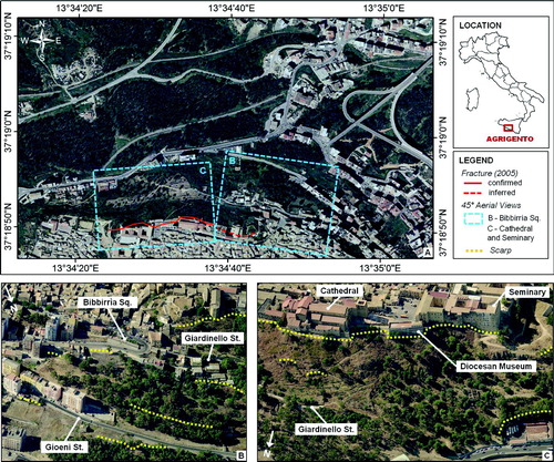
A significant part of the cultural heritage of the city of Agrigento has been damaged over the last century by geomorphologic processes affecting the area. In particular, on 28 February 1944 a landslide involved the northern slope of Girgenti hill, on which the urban area is built. This landslide caused extensive damage especially in the Bibbirrìa Sq. area (, also affecting also St. Gerlando's Cathedral (eleventh to twelfth century) and, with less severe consequences, the Bishop's Seminary (sixteenth to seventeenth century) (. Additional failures have been recorded on the Cathedral, the Diocesan Museum (founded in 1964) and the Seminary as a result of the 19 July 1966 landslide that affected the western sector (Arab quarter) of the town (Cotecchia, D'Ecclessis, & Polemio, Citation1995). In recent years, damage to historic buildings has increased and new geological and geomorphological studies have been performed in order to plan a monitoring system and mitigating action for their preservation.
2. Geological setting
Located in central-southern Sicily at edge of the Maghreb-Apennine thrust belt, the municipality of Agrigento is characterized by a geological setting influenced by the geodynamic evolution of the Caltanissetta basin. Along the Maghreb-Apennine thrust front, the Gela Nappe forms a large arcuate salient and, in the area of Agrigento, has a NW-SE structural trend. Deformation in the basin is dominated by large open folds with 1–3 km amplitude and 5–10 km half wavelength across the general strike; they characterize the geological and structural setting and some of them are cored by southward blind thrusts (Grasso et al., Citation1995; Lickorish, Grasso, Butler, Argnani, & Maniscalco, Citation1999).
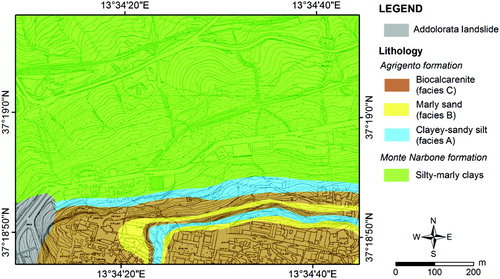
In the area of Agrigento, a regressive Miocene and Plio-Pleistocene succession of the Gela Nappe can be distinguished. This succession consists mainly of clays, sands and calcarenites and, from the bottom to the top, is constituted by: a basement of terrigenous molasse deposits and the Gessoso Solfifera formation (Miocene), the Trubi formation (Lower Pliocene), and Mt. Narbone (Middle-Upper Pliocene) and Agrigento (Lower Pleistocene) formations. Closing the succession, Pleistocene terraced marine deposits and recent alluvial and coastal deposits crop out (e.g., Catalano & D'Argenio, Citation1982; Grasso & Butler, Citation1991; Motta, Citation1957). The Mt. Narbone formation is made up by blue-grey silty-marly clays up to 200 m thick, with thin silty sand levels; it was laid down in platform-lithofacies, with bathyal depths (300–400 m). This formation crops out in the Rupe Atenea valley and at the bottom of Girgenti hill. The Agrigento formation consists of the alternation of three facies, characterized by lateral-vertical transitions: yellow-grey clayey-sandy silt (facies A), marly sand with bioturbation and macrofossils (facies B), and biocalcarenite and biocalcirudite (facies C). Four cycles of these facies, corresponding to as many eustatic changes recorded during Lower Pleistocene, can be recognized within the formation (Cotecchia, Fiorillo, Monterisi, & Pagliarulo, Citation2005; Fiorillo, Citation1999).
This geological framework promotes the development of landslides. In detail the top of the slope is characterized by the presence of the highly fractured calcarenites of the Agrigento formation which lie on the clays of the Mt. Narbone formation () allowing the formation of rockfall phenomena. The lower part of the slope, formed mainly of clay, is primarily affected by earthflows and roto-translational landslides.
Figure 2. Geological map of the study area (Cigna et al., Citationforthcoming).
3. Integrated geomorphological mapping
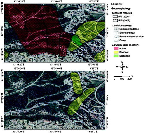
An integrated approach, exploited to produce an updated geomorphological map of Agrigento (Main Map), has been used (). The first step is to create a preliminary geomorphological map starting from landslides mapped at the scale 1:10,000 on the Hydrogeological Setting Plan of San Leone river basin published in 2006 (PAI, Piano di Assetto Idrogeologico; i.e. Regione Siciliana, Citation2006) and on the Landslides Inventory in Italy (IFFI, Inventario dei Fenomeni Franosi in Italia; CitationISPRA, 2007). The integration of these data revealed that about 50% of the northern sector of Agrigento is affected by landslides that, in 2006, were mostly active (). Landslide states of activity recorded within the PAI and IFFI inventories were determined by means of photo-interpretation of multi-temporal aerial photographs and targeted field surveys carried out in the late 1990s. The map produced from the combination of PAI and IFFI inventories has been initially updated through photo-interpretation, using aerial photos of 2003, and successively throughout radar-interpretation (Cigna, Del Ventisette, Liguori, & Casagli, Citation2011; Farina, Casagli, & Ferretti, Citation2008; Righini, Pancioli, & Casagli, Citation2012) using 1992–2010 radar data. Finally, detailed geomorphological surveys were carried out in 2006, 2007 and 2011, to validate the updated geomorphological map.
Figure 3. Flowchart of the procedure used to carry out the geomorphological mapping in Agrigento, Italy.
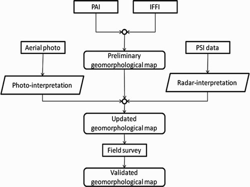
Figure 4. Pre-existing landslide mapping in the north-western sector of Agrigento. (A) PAI (Piano di Assetto Idrogeologico, Hydrogeological Setting Plan; CitationRegione Siciliana, 2006); (B) IFFI (Inventario dei Fenomeni Franosi in Italia, Landslide Inventory in Italy; ISPRA, Citation2007).
3.1. Photo-interpretation
The interpretation of aerial photographs provides a useful and accurate assessment of geomorphic changes, particularly when an accurate evaluation of mass wasting is needed. Careful observation of stereo aerial photographs, using a mirror stereoscope, is the most common technique for the identification of large areas affected by landslides, which is a crucial factor for land use planning activities. A set of eight colour aerial photographs (scale 1:8000), obtained by Impresa Rossi Luigi S.r.l., commissioned by the Assessorato Regionale Territorio e Ambiente, Dipartimento di Urbanistica, Servizio cartografico e informatico di Palermo was used. The photos, acquired in early September 2003 (Volo colore 2003, lotto 2), were used as stereo pairs, over the same area at a flying height of 1200 m to perform the photo interpretation and the geomorphological map. Two tracks of four orthophotos were chosen to cover the study area (): track 149 (photo from 2792 to 2795) and track 152 (photo from 2748 to 2751; ). The focal length of the optical system used for the acquisition of these set of photographs is 153 mm. The overlap between the colour photographs is 60%. Landslide boundaries and scarps were observed from an aerial photographic survey and digitized into a GIS. A set of characteristics (shape, size, colour, topography) were used to detect and map landslides. Among these characteristics shape was the most useful for the detection of landslides in combination with the vertical exaggeration of the stereoscopic vision (Guzzetti et al., Citation2012).
Figure 5. Coverage, tracks and frames of the eight aerial photographs at scale 1:8000 used for stereographic photo-interpretation in Agrigento.
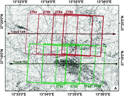
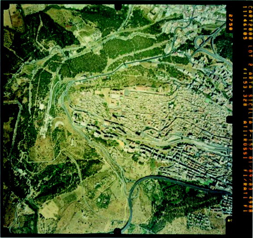
Figure 6. Example of aerial photograph covering the western portion of the urban area of Agrigento (track 152, frame 2750; ).
3.2. Persistent Scatterer Interferometry analysis
Four datasets of Persistent Scatterer Interferometry (PSI) measurements, obtained through the processing of long temporal stacks of Synthetic Aperture Radar (SAR) satellite imagery, were used to analyse the deformation history of Agrigento. PSI technologies employ multi-temporal archives of SAR data and allow the identification of a set of highly reflective targets on the ground – the so-called ‘Persistent Scatterers’ (PS) – for which precise displacement measurements are extracted (e.g. CitationCrosetto, Monserrat, Iglesias, & Crippa, 2010; CitationFarina, Moretti, Colombo, Fumagalli, & Manunta, 2004b; CitationFerretti, Prati, & Rocca, 2001). These approaches are increasingly used for the detection and monitoring of ground deformation induced by very slow surface processes (up to some tens of centimetres per year), and can successfully support conventional in situ investigations (e.g. CitationBianchini, Cigna, Righini, Proietti, & Casagli, 2012; CitationBürgmann, Hilley, & Ferretti, 2006; Cigna, Del Ventisette, Liguori, & Casagli, Citation2010, Citation2011; CitationFarina, Colombo, Fumagalli, Gautieri, & Moretti, 2004a; CitationHilley et al., 2004). ERS1/2 images acquired in 1992–2000 along descending orbits, ENVISAT images acquired in 2002–2010 along descending and ascending orbits, and RADARSAT1 S3 data acquired in 2003–2007 in ascending mode were analysed for Agrigento (). These sensors operate in C band (wavelength of 5.6 cm) and their images are high resolution (20–30 m on the ground). The nominal repeat cycle is 24 days for RADARSAT1, and 35 days for ERS1/2 and ENVISAT satellites; thus, the PSI-based study allows the analysis of the investigated area with a monthly sampling frequency. ERS1/2 descending and RADARSAT1 ascending stacks were processed through the Permanent Scatterers InSAR (PSInSAR) technique by TRE S.r.l., while the ENVISAT ascending and descending stacks were processed by e-GEOS with the approach of Persistent Scatterers Pairs – Differential InSAR (PSP-DIFSAR). Both these techniques operate by comparing the phase signals recorded by the radar sensors at different acquisition times and discriminating the phase components related to deformation with respect to those due to topography, presence of atmosphere and noise, by exploiting their different correlations in the temporal and spatial domains. Further details about the processing strategies of the PSInSAR and PSP-DIFSAR techniques can be found in CitationFerretti et al. (2001) and CitationCostantini, Iodice, Magnapane, and Pietranera (2000), respectively.
Table 1. PSI data stacks analysed for the area of Agrigento.
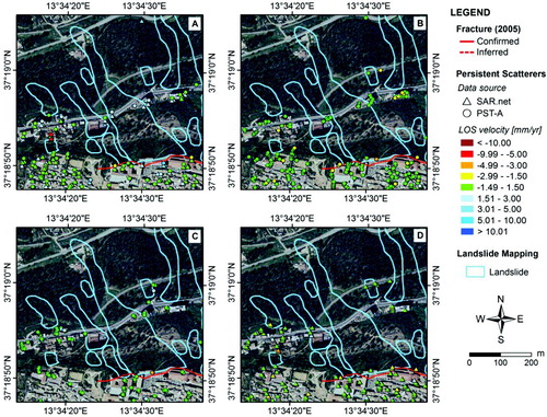
In the north-western sector of the town, many ERS1/2, ENVISAT and RADARSAT1 Persistent Scatterers were identified on the urban structures and infrastructures, including the most damaged historic buildings located along Duomo St., Giardinello St., Bibbirrìa Sq. and Gioeni St. (). However on the steep unstable slope of Girgenti hill no radar targets were detected, due to the lack of reflective structures, and the presence of vegetation which causes high temporal decorrelation. The displacements observed for the identified PS reflect the consequences of the landslides affecting Girgenti hill on the overlying buildings and structures. In all the PS datasets, average ground displacements of the analysed PS reveal the overall stability of the investigated area and the absence of significant motions at a regional scale.
Figure 7. Deformation velocities in the north-western area of Agrigento, measured in 1992–2010 along the satellite LOS of ERS1/2 descending (A), ENVISAT descending (B) and ascending (C), and RADARSAT1 ascending (D). Data stack dates, processing techniques and orbits are summarized in .
4. Results
Using photo interpretation 18 landslides were identified and mapped along the northern side of the Girgenti hill. The boundary of these landslides were verified during the 2011 field investigation campaign where few differences between the situation portrayed in the aerial photo of the 2003 and the contemporary framework were observed. The most important recognized landslides are placed westward of the Cathedral of St. Gerlando (), beneath the Diocesano Museum, where there is a wide area affected by slope movement. The presence of well-developed main scarps and toes allowed an accurate identification of the boundaries using orthophotos. The displaced mass morphology suggests that these landslides can be considered shallow-seated landslides. On the eastern side of the hill several smaller slope failures were detected. They correspond roughly to the small streams which flow northeastward. No displaced masses can be recognized for these landslides because the small streams tend to remove the material deposited in this area. The whole top of the scarp of the Girgenti hill is affected by rockfalls and rock topples because of the presence of cohesive and fractured material on the top (). For those landslides, where a good density of PS was identified, the PSI data allowed a better definition of the landslide boundaries, as well as an analysis of the temporal evolution of the surface displacements affecting the area, and an assessment of the state of activity of the observed phenomena. The greatest movements detected in the investigated area correspond to structural instability of the Cathedral and the Seminary, located at the edge of the unstable slope and showing the severest damage. Line-of-Sight (LOS) velocities up to 4–5 mm/year are measured at the Diocesan Museum, in both ascending and descending orbits, and up to 2–3 mm/year detected in the north-western portion of the Seminary and in the north aisle of the Cathedral, providing evidence of recent settlement of these buildings. The latter are located close to the main scarps of the major landslides identified in the area, and show quite clearly the effects of sub-vertical motion characterizing the upper portion of these landslides. Movements of 5–7 mm/year are also measured on some buildings along Giardinello St., west of the area of Bibbirrìa Sq. landslide, which occurred in 1944. Very few PS highlight LOS deformation rates higher than ±1.5 mm/year (positive and negative velocities indicate LOS movements toward and away from the satellite, respectively). In the most damaged areas on the NW side of the town, the presence of ground motions faster than those detected cannot be ruled out. In this area, land displacements are oriented in the N–S direction, and both the ascending and descending satellite LOS (almost parallel to the E–W direction) have low sensitivity to these motion components (displacement detectable by PSI is about 10%). The low densities or even the lack of PS observed along the Girgenti hill could be overcome in the future with the installation of artificial reflectors, easily detectable within the radar scenes. This strategy might facilitate the long-term monitoring of the unstable slope, guaranteeing the presence of targets in some locations selected within the investigated area, and providing valuable support for the improvement of the landslide mapping, as well as for hazard and risk assessment. The ‘Validated geomorphological map’, obtained by combining the ‘Updated geomorphological map’ with the results of 2011 field survey, shows a strong agreement with results obtained through remote sensing data.
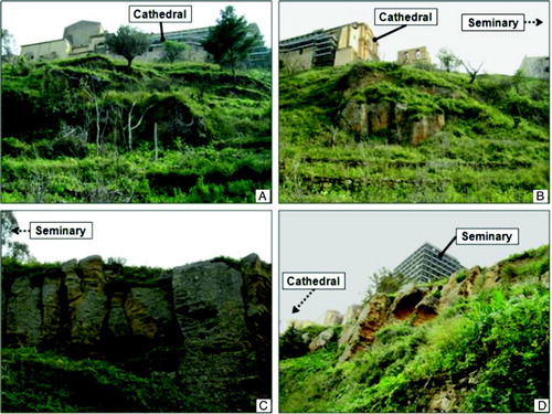
Figure 8. Photos of the north-western slope of Girgenti hill, taken during the 2007 and 2011 field surveys.
5. Conclusions
Management of natural hazards is crucial in densely populated regions. The forecast of risk related to landslide phenomena is needed to perform urban planning activities which involve civil protection and cultural heritage. A quick and low-cost methodology for monitoring and evaluating possible risk scenarios can be useful for decision-making and planned mitigation measures.
The results obtained combine landslide inventory with maps derived from field survey, aerial photographs and satellite-radar data, from which the ‘updated’ and ‘validated geomorphological map’ () of the study area were produced to be used in future mitigation plans. Through this integrated methodology 18 landslides were mapped along the northern side of the Girgenti hill. The most important landslides affecting the study area, detected also from highest PS velocity, occurred mainly between 1992 and 2000; however the zone close to the cathedral was active in the period 2003–2010 showing velocities up to 3 mm/year. This study demonstrates the usefulness of this approach to achieve an accurate geomorphological map which could be suitable in future landscape and cultural heritage management.
Software
The geomorphological map was drawn by hand from the aerial photos. The recognized landslides were digitalized as a single polygon in GIS, using ESRI ArcGis 9.3. A unique code was assigned to the 18 identified polygons, classified using their related characteristics (geomorphological features, origin, processes, state of activity and hazards).
Supplemental Material - Map
Download PDF (64.9 MB)Acknowledgements
This work was performed in the framework of the Italian project SAR.net, funded by the Italian Civil Protection Department, and ‘Interpretazione di dati telerilevati per lo studio delle condizioni di dissesto nel Comune di Agrigento e nel centro abitato di Naro’, funded by the Regional Civil Protection Department, Sicily. Access to IFFI (Inventario dei Fenomeni Franosi in Italia) was performed through the ISPRA's WMS service, while PAI (Piano Stralcio di Bacino per l'Assetto Idrogeologico) was made available through the website of the Department of the Environment and Territory, Sicilian Region. ERS1/2 and ENVISAT Persistent Scatterers products of the Piano Straordinario di Telerilevamento Ambientale (PST-A) project were made available through the WMS service of the Italian Ministry for the Environment, Land and Sea. RADARSAT1 and ERS1/2 Persistent Scatterers products were made available through the SAR.net project.
Additional information
Notes on contributors
Francesca Cigna
Present address: British Geological Survey, Nicker Hill, Keyworth, Nottingham NG12 5GG, UKVincenzo Liguori
Present address: Kore University of Enna, Cittadella Universitaria, 94100 Enna, ItalyReferences
- Bianchini , S. , Cigna , F. , Righini , G. , Proietti , C. and Casagli , N. 2012 . “ Landslide hotspot mapping by means of Persistent Scatterer Interferometry ” . In Environmental Earth Sciences DOI: 10.1007/s12665-012-1559-5
- Bürgmann , R. , Hilley , G. E. and Ferretti , A. 2006 . Resolving vertical tectonics in the San Francisco Bay area from Permanent Scatterer InSAR and GPS analysis . Geology , 34 ( 3 ) : 221 – 224 . DOI: 10.1130/G22064.1
- Catalano , R. and D'Argenio , B. 1982 . “ Schema geologico della Sicilia ” . In Guida alla geologia della Sicilia occidentale Edited by: Catalano , R. and D'Argenio , B. 9 – 41 . Soc. Geol. It. Guide Geologiche Regionali
- Cigna , F. , Del Ventisette , C. , Gigli , G. , Menna , F. , Agili , F. Liguori , V. forthcoming . “ Geological investigations and 1992–2007 Persistent Scatterer Interferometry for the analysis of ground instability affecting the old town of Agrigento (Italy) ” . Italian Journal of Geosciences
- Cigna , F. , Del Ventisette , C. , Liguori , V. and Casagli , N. 2010 . “ InSAR time-series analysis for management and mitigation of geological risk in urban area ” . International Geoscience and Remote Sensing Symposium (IGARSS), art. no. 5653476, 1924–1927. DOI: 10.1109/IGARSS.2010.5653476
- Cigna , F. , Del Ventisette , C. , Liguori , V. and Casagli , N. 2011 . Advanced radar-interpretation of InSAR time series for mapping and characterization of geological processes . Natural Hazards Earth System Science , 11 ( 3 ) : 865 – 881 . DOI: 10.5194/nhess-11-865-2011
- Costantini , M. , Iodice , A. , Magnapane , L. and Pietranera , L. 2000 . “ Monitoring terrain movements by means of sparse SAR differential interferometric measurements ” . International Geoscience and Remote Sensing Symposium (IGARSS), 7, art. n. 860390, 3225–3227. DOI: 10.1109/IGARSS.2000.860390
- Cotecchia , V. , D'Ecclessis , G. and Polemio , M. 1995 . “ La dinamica dei versanti della Valle dei Templi di Agrigento ” . In I Conv. Naz. Geologia Applicata and Ital. Sect. of IAEG, Giardini Naxos (ME), 11–15 Giugno 1995 , Bari , , Italy : Geol. Appl. e Idrog .
- Cotecchia , V. , Fiorillo , F. , Monterisi , L. and Pagliarulo , R. 2005 . Slope instability in the Valley of Temples, Agrigento (Sicily) . Giornale di Geologia Applicata , 1 : 91 – 101 . DOI: 10.1474/GGA.2005-01.0-09.0009
- Crosetto , M. , Monserrat , O. , Iglesias , R. and Crippa , B. 2010 . Persistent Scatterer Interferometry: Potential, limits and initial C- and X-band comparison . Photogrammetric Engineering and Remote Sensing , 76 ( 9 ) : 1061 – 1069 .
- Farina , P. , Casagli , N. and Ferretti , A. 2008 . “ Radar-interpretation of InSAR measurements for landslide investigations in civil protection practices ” . In V.R. Schaefer, R.L. Schuster, & A.K. Turner (Eds.), Proceedings of the 1st North American Landslide Conference, Vail, Colorado, 3rd–8th June 2007 (pp. 272–283)
- Farina , P. , Colombo , D. , Fumagalli , A. , Gautieri , E. and Moretti , S. 2004a . “ Integration of Permanent Scatterers analysis and high resolution optical images within landslide risk analysis ” . In European Space Agency (Special Publication) ESA SP (550) 88 173 – 180 .
- Farina , P. , Moretti , S. , Colombo , D. , Fumagalli , A. and Manunta , P. 2004b . “ Landslide risk analysis by means of remote sensing techniques: Results from ESA/SLAM project ” . In IEEE International Geosciences and Remote Sensing Symposium (IGARSS) 1 62 – 65 . DOI: 10.1109/IGARSS.2004.1368945
- Ferretti , A. , Prati , C. and Rocca , F. 2001 . Permanent Scatterers in SAR Interferometry . IEEE Transaction on Geosciences and Remote Sensing , 39 ( 1 ) : 8 – 20 . DOI: 10.1109/36.898661
- Fiorillo , F. 1999 . Assetto stratigrafico e strutturale dei terreni nella Valle dei Templi (Agrigento) . Bollettino della Società Geologica Italiana , 118 : 601 – 609 .
- Grasso , M. and Butler , R. W.H. 1991 . “ Tectonic controls on the deposition of late Tortonian sediments in the Caltanissetta basin of central Sicily. Atti del convegno ‘Giornate in memoria di Leo Ogniben’ ” . In Memorie della Società Geologica Italiana, XLVII 313–324
- Grasso , M. , Miuccio , G. , Maniscalco , R. , Garofalo , P. , La Manna , F. and Stamilla , R. 1995 . Plio–Pleistocene structural evolution of the western margin of the Hyblean Plateau and the Maghrebian foredeep, SE Sicily. Implications for the deformational history of the Gela Nappe . Annales Tectonicae , 9 ( 1–2 ) : 7 – 21 .
- Guzzetti, F., Mondini, A.C., Cardinali, M., Fiorucci, F., Santangelo, M., & Chang, K.-T. (2012). Landslide inventory maps: New tools for an old problem. Earth-Science Reviews, 112(1–2), 42–66.
- Hilley , G. E. , Burgmann , R. , Ferretti , A. , Novali , F. and Rocca , F. 2004 . Dynamics of slow-moving landslides from Permanent Scatterer analysis . Science , 304 ( 5679 ) : 1952 – 1955 .
- ISPRA . 2007 . Inventario dei Fenomeni Franosi in Italia (IFFI) Retrieved July 29, 2011, from http://www.apat.gov.it/site/it-IT/Progetti/IFFI_-_Inventario_dei_fenomeni_franosi_in_Italia/
- Lickorish , W. H. , Grasso , M. , Butler , R. W.H. , Argnani , A. and Maniscalco , R. 1999 . Structural style and regional tectonic setting of the ‘Gela Nappe’ and frontal part of the Maghrebian thrust belt in Sicily . Tectonics , 18 ( 4 ) : 655 – 668 .
- Mantovani , F. , Soeters , R. and Van Westen , C. J. 1996 . Remote sensing techniques for landslides studies and hazard zonation in Europe . Geomorphology , 15 : 213 – 225 .
- Metternicht , G. , Hurni , L. and Gogu , R. 2005 . Remote sensing of landslides: An analysis of the potential contribution to geo-spatial systems for hazard assessment in mountainous environments . Remote Sensing of Environment , 98 : 284 – 303 .
- Motta , S. 1957 . Nota descrittiva geologica della tavoletta Agrigento (271-IV-NE), con particolare esame della serie gessoso-solfifera in essa esistente . Bollettino del Servizio Geologico d'Italia, LXXVIII , (4–5), 519–567
- Regione Siciliana . 2006 . Piano Stralcio di Bacino per l'Assetto Idrogeologico (PAI), Bacino Idrografico del Fiume San Leone ed Area Intermedia compresa fra i Bacini del F. San Leone e del F. Naro (067). Regione Siciliana, Assessorato Territorio e Ambiente Retrieved July 29, 2011, from http://www.sitr.regione.sicilia.it/pai/bac067.htm
- Righini , G. , Pancioli , V. and Casagli , N. 2012 . “ Updating landslide inventory maps using Persistent Scatterer Interferometry (PSI) ” . In International Journal of Remote Sensing, 33(7) 2068 – 2096 . DOI: 10.1080/01431161.2011.605087