Abstract
Land use thematic maps are essential for the implementation of land use planning. China launched the third round of its land use planning in 2003, and the making of land use thematic maps series is one of the innovations for the new planning. The objective of this paper is to provide information about generating county-level land use thematic maps. The study area, Dachang Hui Autonomous County (178 km2), is located in Northern China and shares a boundary with Beijing. Methods for generating thematic land use maps are presented. These thematic maps include an existing land use map, zoning map for proposed land use, prime farmland protection map, zoning map for construction land expansion, planned land consolidation map, and planned major land use projects map. The scale for these maps is 1:50,000. All these maps are useful for researchers and local government, allowing them to be used as a reference for the study of land use mapping and support land resource management and planning.
1. Introduction
Land use planning is an important process for the macro-control of urban and rural development. Since 1987, China has implemented three rounds of land use planning with the first round of national land use planning (1990–2000) being completed in 1993. Due to the lack of theoretical and technical support, this planning was not carried out. During 1997 and 2000, the development of the second round of land use planning (1997–2010) was completed and implemented by the end of 2010. It effectively protected cultivated land and promoted socio-economic development in that period. China's third round of nationwide land use planning (2006–2020) started in 2003 and was targeted for completion in 2010 initially, but in fact different provinces used different schedules. Some provinces have completed and complemented this planning, while some are still in preparation (CitationDong, 2007). One of the innovations for this round of land use planning is making land use thematic maps.
The major goals of the third round of national land use planning is to protect ecological land and cultivated land, control the growth of construction land, and rationally arrange spatial patterns of different land use types in order to generate maximum economic, social, and environmental benefits (CitationHu et al., 2010).Thematic maps primarily indicate conversion to construction land from other land use types, which is reflected in the zoning map for construction land expansion and prime farmland protection (CitationDong et al., 2010).
In this paper, we present a practical example of generating thematic maps for land use planning with the assistance of a geographic information system (GIS). These maps are different from western countries' land use planning maps (CitationDilisio & Russo, 2010; CitationTapiador & Casanova, 2003). They would be useful for researchers studying land use thematic mapping and local government officials to make land use management-related decisions. The study area, Dachang Hui Autonomous County, Hebei Province (hereafter referred to as Dachang county) is a typical region located in Northern China (116°48'–117°03'E; 39°49'–39°58'N), with an area ∼178 km2. The area has a warm temperate continental monsoon climate with an average annual temperature of 11.2°C (average maximum 26°C in July and average minimum −5°C in January). Total annual precipitation is about 560 mm, and terrain in the county has an elevation between 239 and 286 m above sea level. The major land use type is cultivated land (55%), urban and rural built-up land (24%), forests (7%), agricultural facility land (7%), water (2%), transportation and water conservation land (2%), and natural reserves (3%).
2. Methods
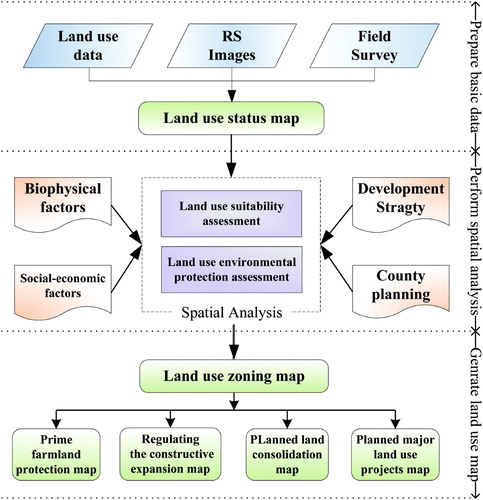
Production of the land use thematic maps proceeded as follows: (1) data collection (1:50,000 land use survey data) and mapping existing land use types; (2) land use suitability analysis using GIS for mapping different land use zones; and (3) production of a series of thematic land use planning maps.
Current land use data together with a digital elevation model (DEM; 30 m spatial resolution) and other data, such as county development planning and transportation planning, were requested from local governments. All of the spatial data were imported into a database with a consistent projection system: (Datum: WGS84 and Projection: Krasovsky). The existing land use was studied and mapped at this stage.
In the second stage, we analyzed land use suitability and conservation plans. Here, we followed the methods used by CitationCengiz and Akbulak (2009) and CitationDoygun, Alphan, and Gurun (2008). The county planning maps were rasterized and a weighted overlay was generated with the existing land use map and the maps of biophysical and socioeconomic factors (such as soil nutrient, transport accessibility, and population density, etc.) in order to generate the suitable zones for different land use types.
Finally, the other four land use planning maps (zoning map for proposed land use, prime farmland protection map, zoning map for construction land expansion, planned land consolidation map, and planned major land use projects map) were also generated based on the land use zoning map ().
Figure 1. Flowchart of the thematic maps generation.
3. Thematic maps for the county-level land use planning
The Existing Land Use Map highlights the distribution of land utilization for the year 2005. One general design principle is to use a warm color for built-up land and a cooler color for non-built-up land use types. Using these two categories can easily protect cultivated land and control urban growth. The warm colors are used for urban and town construction land (red), rural settlement (pink), and mining land (brown). Cultivated land (yellow), orchard (light green), forest (green), and water (rivers or lakes); cyan are also shown.
The Zoning Map for Proposed Land Use is used to coordinate different land use types. Five zones were identified: prime farmland protection, ordinary agriculture, human settlement, incompatible industry, and environmental risk control. Special regulation rules were created for each zone. The map identifies three major areas for the human settlement zone: (1) Dachang town, which is the capital of Dachang county; (2) Qigezhuang town, which is the provincial-level Industrial park in the southwest of Dachang county – in the northern part is the minority industrial park; and (3) some small rural settlements spread across the countryside. The yellow area is the prime farmland protection zone. The orange area is the ordinary agriculture zone, it includes orchard, agricultural facility land, and construction land needed to be reclaimed. The use of the incompatible industry zone is mainly for mining, which could not be too close to human settlements. The major land use in the environmental risk control zone are natural reserves, including pond, irrigation land, and other land use types which are vulnerable to ecosystem degradation. This zone is distributed along the river bank, only minor construction for protecting the environment can be performed.
The Prime Farmland Protection Map indicates where prime farmland is located. The map is made based on the prime farmland zone on the Zoning Map. Most of the cultivated land and a few orchards are located in the prime farmland zone. According the China's 1998 Land Administration Law, anyone who needs to change land utilization in the prime farmland zone, requires permission from the state council. Cultivated land and orchard, which are not in the prime farmland zone, could be converted into other land uses using official procedures. So this map can be used to protect prime farmland and ensure food security locally.
The Zoning Map for Regulating Construction Land Expansion is made based on human settlements in Proposed Land Use Map. In order to control disorderly settlement sprawl and aid conservation, four zones were created: constructive expansion permitted zone, constructive expansion conditionally permitted zone, constructive expansion restricted zone, and constructive expansion prohibited zone. Constructive expansion permitted zone is the planned areas where human settlements can be located legally, while constructive expansion conditionally permitted zone is an elastic zone for new human settlements. Only by special public request and government approval can this zone be used for human settlements; otherwise it should be used for agricultural purposes only. In the constructive expansion prohibited zone, any new construction is prohibited except for environmental conservation and protection. In the constructive expansion restricted zone, only linear construction land (such as highway and railway) can be constructed.
In order to increase cultivated land, some parcels of land were planned for consolidation and reclamation. The Planned Land Consolidation Map shows the distribution of the key regions for construction land consolidation, agricultural land consolidation, reclamation and development. Ancillary information about the key regions, such as the total area, and areas for the net increase of cultivated land are presented in the map. All these regions are located in the ordinary agricultural zone in the Proposed Land Use Zone Map.
The Planned Major Land Use Projects Map shows planned major land use projects during the planning period (2006–2020). These projects include road construction, water conservation and irrigation, environmental protection, and power plant construction. In order to keep the strictness of the land use planning, projects that are not listed in the maps are not permitted to use land.
4. Conclusions
Land use planning maps indicate overall and special arrangements of land use types, according to land resources/land suitability and the demands of economic and social development. There are two important contributions of the thematic maps. First, they provide a template for making land use maps. The specified seven maps comprehensively indicate existing or planned land use. Existing land use data at the standard required by the Second National Land Survey of China make it straight forward to perform analysis for land use suitability and environmental protection. The second contribution lies in that it prescribes the scope for settlement sprawl and the distribution of prime farmland. The former can effectively control the scattered settlement's spatial pattern, while the latter allows for a harmonious and beautiful rural landscape. Hopefully, this research can motivate future work to perform land resource management to fully support social and economic development.
Software
ESRI ArcGIS 9.3 was used to build the database, integrate, process, edit the different sources spatial datasets, perform spatial analyses, and make thematic maps.
Supplemental Material - Map
Download PDF (4.7 MB)Acknowledgements
The research was supported by National Natural Sciences of Foundation of China (NO: 41001046), Fundamental Research Funds for the Central Universities of China (NO: 1117020910), and PAPD (Project Funded by the Priority Academic Program Development of Jiangsu Higher Education Institutions). We are grateful for the suggestions and comments from three reviewers. However, any errors or shortcomings in the paper are the responsibility of the authors.
References
- Cengiz , T. and Akbulak , C. 2009 . Application of analytical hierarchy process and geographic information systems in land-use suitability evaluation: A case study of Dumrek village (Canakkale, Turkey) . International Journal of Sustainable Development and World Ecology , 16 ( 4 ) : 286 – 294 .
- Dilisio , A. and Russo , F. 2010 . Thematic maps for land-use planning and policy decisions in the Calaggio Stream catchment area . Journal of Maps , 2010 : 68 – 83 .
- Dong , Z. 2007 . Land use planning in China . Ontario Planning Journal , 22 ( 2 ) : 16 – 18 .
- Dong , Z. , Ying , W. , Li , M. , Sun , X. , Li , F. and Tian , Z. 2010 . Mapping standard of country general land-use planning , Beijing : Standards Press of China .
- Doygun , H. , Alphan , H. and Gurun , D. K. 2008 . Analysing urban expansion and land use suitability for the city of Kahramanmaras, Turkey, and its surrounding region . Environmental Monitoring and Assessment , 145 ( 1–3 ) : 387 – 395 .
- Hu , C. , Dong , Z. , Tian , Z. , Deng , H. , Ying , W. and Sun , X. 2010 . Guideline for county general land use planning , Beijing : Standards Press of China .
- Tapiador , F. J. and Casanova , J. L. 2003 . Land use mapping methodology using remote sensing for the regional planning directives in Segovia, Spain . Landscape and urban planning , 62 ( 2 ) : 103 – 115 .