Abstract
A gridded dataset representing near surface atmospheric fields has been developed to allow spatial analysis of long-term weather patterns over an area with significant climate spatiotemporal variability, Greece. The atmospheric elements considered are means of near surface temperature, means of relative humidity, as well as monthly and annual accumulated precipitation. The extracted patterns are based on the gridded European Centre for Medium-Range Weather Forecast (ECMWF) daily analyses interpolated on a regular 0.25° × 0.25° grid. Long-term means on annual and monthly bases for an 18-year reference period (1990–2007), are estimated for the continuous fields. Monthly and annual averages of accumulated precipitation for the period of 1980–2001 have also been created from near to analysis ECMWF forecasts and records gathered from surface meteorological stations. The extracted dataset has been accordingly formatted in order to allow visualization of the long-term atmospheric variables using a geographic information system.
1. Introduction
Various long-term climatic datasets on gridded forms have been developed based on both observed and reanalyses data for over a decade (CitationCaesar, Alexander, & Vose, 2006). The ‘WorldClim’ database is compiled from monthly averages of climate as measured at weather stations from a large number of global, regional, national, and local sources, mostly for the 1950–2000 period (CitationHijmans et al., 2005). It's data, in the form of climatic surfaces, have a very fine horizontal resolution of 30″ × 30″. Despite the high spatial resolution, the surfaces cannot resolve atmospheric disturbances with a spatial scale of 1 km particularly over areas with sparse meteorological information. Moreover there is a lack of information over water bodies since climatologies are exclusively defined over the Earth's surface.
Reanalysis fields are produced from advanced data assimilation systems blending near to analysis model forecasts, as background fields, with land surface, ship, rawinsonde, aircraft, radar, and satellite measured data. A joint project between the National Centers for Environmental Prediction (NCEP) and the National Center for Atmospheric Research (NCAR) resulted in the development of 40-year reanalysis fields for the period 1957–1996 on horizontal resolution of T62 (∼210 km) with 28 vertical levels (CitationKalnay et al., 1996). CitationMesinger et al. (2005) created a similar long-term set of consistent climate data on a regional scale for the North America domain. It consists of a high-resolution, high-frequency, atmospheric and land surface hydrology dataset for the North American region covering the 25-year period 1979–2003.
Recently, CitationPapadopoulos et al. (2011) presented a sophisticated downscaling procedure that was applied to reproduce high-resolution historical records of the atmospheric conditions across the Mediterranean region. The procedure was based on the dynamical downscaling of the European Center for Medium-Range Weather Forecasts (ECMWF) Re-Analyses (ERA-40) with the aid of the atmospheric model of the POSEIDON weather forecasting system (CitationPapadopoulos, Kallos, Katsafados, & Nickovic, 2002). ECMWF produced high-quality global reanalyses of atmosphere, land, and ocean-wave conditions for the past four decades. ERA-40 describes atmospheric conditions from September 1957 to August 2002 at a spectral resolution of T159 (∼1.125 deg) with 60 model levels (CitationUppala et al., 2005). The mesoscale meteorological model of the POSEIDON weather forecasting system was appropriately configured to run at 10 km grid spacing (as opposed to 125 km grid spacing of the ERA-40). The ECMWF reanalysis data and the ECMWF operational analyses were used to force the mesoscale model at its boundaries and thereafter the mesoscale model downscales the global data by producing fine-scale weather patterns consistent with the coarse-resolution features in the forcing data.
Despite ERA-40, ECMWF produces routine global analyses for the four main synoptic hours 00, 06, 12, and 18 UTC on a daily basis. The horizontal and vertical resolution of operational analyses varies from T106 (∼1.125 deg) in 1986 to T799 (∼0.15 deg) in 2006 and from 19 to 90 vertical levels.
In this study, long-term atmospheric patterns at a regional scale are analyzed through their integration with a geographical information system (GIS). To this end, a gridded dataset consisting of near to Earth surface climate fields has been developed based on ECMWF operational analyses. A number of thematic charts have been produced for various fields such as means of minimum and maximum temperatures, relative humidity as well as monthly and annual accumulated precipitation for an area with significant spatiotemporal climate variability, Greece.
2. Methodology
The extracted dataset was produced from gridded ECMWF daily analyses and interpolated on a regular grid increment of 0.25° × 0.25° for the period 1990–2007 (18 years). The geographical area of data coverage was defined from 18°E to 30°E longitude and from 34°N to 43°N latitude. This configuration is valid for the continuous meteorological data such as air temperature and relative humidity at 2 meters above ground level. Long-term surfaces of the above mentioned fields were extracted from their integration using the four basic synoptic hours (h = 00, 06, 12, and 18 UTC) for the number of days (NDAYS m,y ) of each month (m) of each year (y) during the entire period. Keeping the horizontal distribution constant, the mean monthly temperature for a specific grid point was estimated using the following equation:
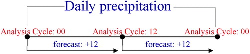
Accumulated precipitation was constructed from near to analysis forecasts based on ECMWF 00 and 12 UTC daily operational cycles for the period 1980–2001 (22 years). Thus, daily precipitation was estimated from the accumulation of 12-hour precipitation provided by 00 and 12 UTC analysis cycles ().
Figure 1. Estimation of the daily accumulated precipitation based on the ECMWF near to analysis forecasts.
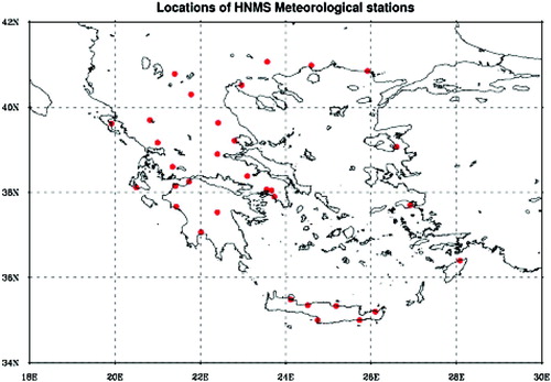
In order to eliminate possible forecast errors in the gridded precipitation data and the deficiency of the relatively coarse horizontal grid resolution of the ECMWF model, a correction method was applied in the gridded precipitation based on a large number of precipitation observations. More specifically, the resolution deficiency may be attributed to the horizontal grid resolution of ECMWF analyses, which have been initially interpolated to 0.25° × 0.25°, and it is not adequate to resolve mesoscale atmospheric disturbances over areas with complex physiographic characteristics. To this end, mean monthly and annual precipitation surfaces depicted on the main map were finally synthesized from the integration of ECMWF daily precipitation for the entire period and the relevant mean monthly and annual precipitation records obtained from 32 surface meteorological stations unevenly distributed over the Greek peninsula (). The meteorological stations are operated by the Hellenic National Meteorological Service (HNMS) and their observational data are available through the Global Telecommunication System (GTS). For the production of the final annual precipitation, the surface observations were interpolated onto the initial ECMWF gridded precipitation using a linear krigging method on a reference cell size of 250 meters. The same method and reference cell have also been applied for the temperature and the relative humidity at 2 meters.
Figure 2. Locations of the 32 surface meteorological stations.
3. Analysis of the long-term atmospheric conditions
The fine horizontal resolution of produced surfaces allows for the identification of long-term atmospheric patterns at a regional scale. The top right chart in the main map depicts the significant spatial variability of the mean annual air temperature in Greece. The temperature range is over 11.2°C, with the lowest found in Northwestern areas and the highest in Southeastern areas. Mean annual maximum temperature is located over Eastern Crete and Rhodes islands where the air temperature at 2 meters reaches 20°C, while mean annual minimum temperature is found over the northwestern and northeastern continental areas of Greece (around 9°C).
Despite the apparent South–North variability in terms of mean annual temperature, the spatial variation of relative humidity in Greece suggests a significant East–West divide (bottom right chart). The Pindos Mountains act as a natural boundary separating the wetter western part from the dryer eastern part of the Greek peninsula. However, mean annual maximum air humidity located in the northern areas of Greece are caused mainly by the passage of frontal zones accompanied with significant amount of humid air masses.
Similar to relative humidity, mean annual precipitation (Kg m−2) shows a significant West-to-East spatial variability. Precipitation, induced in the north-western part of Greece, is mainly caused by the mechanism of orographic lifting along the windward side of the Pindos Mountains. This lifting cools the air masses and leads to cloud formation and eventually to the development of a single or super cells of thunderstorms. In addition, Western Greece is located on the preferential paths of the Mediterranean cyclonic systems accompanied by frontal zones which are responsible for the development of torrential rains especially during autumn and winter. As seen on the Main Map, strong precipitation gradients are also evident at the Western Peloponnese and Rodopi Mountain barriers, while the mean rainfall over Eastern Greece is about the half of the maximum located over the Western areas.
4. Conclusions
A gridded dataset representing near surface atmospheric conditions has been developed for the identification of long-term meteorological patterns in Greece. The atmospheric elements considered in this study are mean temperature and relative humidity as well as accumulated precipitation. Mean values of these elements refer to the period from 1990 to 2007 while annual accumulated precipitation refers to the period from 1980 to 2001. The extracted dataset was initially based on the gridded ECMWF daily analyses on a fine regular 0.25° × 0.25° grid and it is available as raw data following GRIB1 or ASCII formats. The mean annual precipitation was finally estimated by the interpolation of the recorded data from 32 conventional meteorological stations onto ECMWF gridded precipitation. Thus, the surface observations were interpolated onto the initial ECMWF gridded precipitation using a linear krigging method on a reference cell size of 250 meters. The same method and reference cell have been also applied for the temperature and the relative humidity at 2 meters. Historical data at such a high resolution are essential for studies in areas with complex physiographic characteristics and therefore strong climate gradients.
According to the long-term atmospheric patterns, mean annual air temperature shows a significant North-to-South variability while relative humidity suggests a West–East divide where Greece is concerned. Similar to relative humidity, mean annual precipitation shows a significant West-to-East spatial variability with the maximum (over 1000 mm) to be located at the north-western areas. Such local maxima are mainly attributed to the frequent passage of cyclonic systems with frontal zones and to the mechanism of orographic lifting at the windward side of Pindos Mountains. However, the production of additional maps including mean monthly and annual wind speed and near surface direction for wind farm installation as well as the estimation of net solar incoming radiation for photovoltaic applications are planned for the future.
Software
Gridded and surface observational raw data are initially formatted in the common meteorological formats GRIB1 and BUFR, respectively. They are decoded and transformed in the conventional ASCII format using the software NCAR Command Language (NCL-http://www.ncl.ucar.edu). Climate surfaces, in the form of regular longitude-latitude gridded data, are then transformed to Transverse Mercator projection and mapped using ArcGIS 9.3.1.
Supplemental Material - Map
Download PDF (14.9 MB)Acknowledgements
European Centre for Medium Range Weather Forecasts (ECMWF) is gratefully acknowledged for the provision of gridded analyses and surface observational data.
References
- Caesar , J. , Alexander , L. and Vose , R. 2006 . Large-scale changes in observed daily maximum and minimum temperatures: Creation and analysis of a new gridded data set . Journal of Geophysical Research , 111 ( D05101 ) : 1 – 10 . doi: 10.1029/2005JD006280
- Hijmans , R. J. , Cameron , S. E. , Parra , J. L. , Jones , P. G. and Jarvis , A. 2005 . Very high resolution interpolated climate surfaces for global land areas . International Journal of Climatology , 25 : 1965 – 1978 . doi: 10.1002/joc.1276
- Kalnay , E. , Kanamitsu , M. , Kistler , R. , Collins , W. , Deaven , D. Gandin , L. 1996 . The NCEP/NCAR 40-year reanalysis project . Bulletin of the American Meteorological Society , 77 ( 3 ) : 437 – 471 .
- Mesinger , F. , DiMego , G. , Kalnay , E. , Mitchell , K. , Shafran , P. C. Ebisuzaki , W. 2005 . North American regional reanalysis . Bulletin of the American Meteorological Society , 87 ( 3 ) : 343 – 360 .
- Papadopoulos , A. , Kallos , G. , Katsafados , P. and Nickovic , S. 2002 . The Poseidon weather forecasting system: An overview . The Global Atmosphere and Ocean Systems , 8 ( 2–3 ) : 219 – 237 .
- Papadopoulos , A. , Korres , G. , Katsafados , P. , Ballas , D. , Perivoliotis , L. and Nittis , K. 2011 . Dynamic downscaling of the ERA-40 data using a mesoscale meteorological model . Mediterranean Marine Science , 12 ( 1 ) : 183 – 198 .
- Uppala , S. M. , Kallberg , P. W. , Simmons , A. J. , Andrae , U. , Bechtold , V. D. Fiorino , M. 2005 . The ERA-40 re-analysis . Quarterly Journal of the Royal Meteorological Society , 131 ( 612 ) : 2961 – 3012 .