Abstract
Teaching how to map the geomorphology of an area cannot be performed in a satisfying manner only in the lecture room, but requires practical exercises both in the laboratory and in the field. A preliminary study of existing geological maps, geomorphological legends and symbols used in Italy and of the landslide inventory preceded a detailed four-day-long field mapping campaign carried out by students in the framework of their MSc course on ‘Geomorphological Mapping’ at Bologna University. The Geomorphological Map at 1:5000 produced by some of these students is presented in this paper.
The study area is located in the northern Apennines, a few kilometres East of Bologna, along the Idice Valley (N-Italy). Lithologies are mainly composed of clayey and marly sequences ranging in age from Cretaceous to Plio-Pleistocene, sands and sandstones of Pleistocene age, and Messinian gypsum, these last being the most resistant rocks.
Besides the greater scale used in this map, allowing for a more detailed representation of the mapped features, this map also shows the recent evolution of landslides in this actively mass wasting area.
1. Introduction
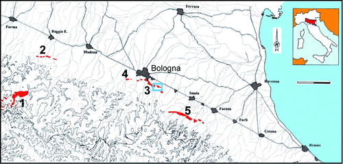
This research is a part of a wider project that aims to produce geomorphological maps for all the gypsum karst areas of the Emilia Romagna region. Gypsum covers around 1% of the surface of the region and is characterised by important surface and underground karst morphologies (CitationDe Waele, Forti, & Rossi, 2011). Large outcrops of gypsum of Triassic age are present in Reggio Emilia province, close to the border with Tuscany (Area 1 in ) (CitationChiesi, De Waele, & Forti, 2010), but most outcrops are Messinian in age, bordering the northern Apennine front, from Reggio Emilia to Rimini. The gypsum outcrops near Bologna have a great historical interest, their caves having been studied for many centuries (CitationAldrovandi, 1648) and the karst processes since the early twentieth century (CitationMarinelli, 1917). Almost 900 caves have been described in these evaporite rocks, with a total development of almost 90 km (CitationLucci & Rossi, 2011). Despite a large number of specific studies on karst and caves, not much has been completed on the surface geomorphology.
Figure 1. Gypsum outcrops in Emilia Romagna region (from CitationLucci & Rossi, 2011): 1. Triassic gypsum of Upper Secchia River; 2–5. Messinian gypsum. The blue box shows the mapped study area.
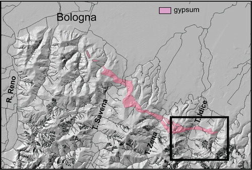
These evaporite areas, due to their lithological variety, are amongst the most diverse and rich geomorphological landscapes around Bologna, and offer a good opportunity to teach geomorphological mapping to students. In particular, the area close to the Castel de' Britti area, located ∼10 km southeast of Bologna, offers a typical example of the northern Apennines. The area is crossed from south to north by the river Idice (). Besides the Rio Olmatello, a small tributary of Idice, most channels are ephemeral and become active only after major rainfall events. The landscape is typical of the entire pede-Apenninic margin, and is dominated by a ridge of Messinian evaporite rocks. The Idice valley floor is almost flat, while hill slopes have average angles of 20–30°. On badlands slopes can reach 40°, while gypsum can also form vertical cliffs of up to 15 m high. Surface drainage in gypsum is absent, with sinkholes and dolines conveying water underground towards one karst spring, presently clogged with artificially accumulated sediments. Part of this area, of high naturalistic interest, is included in the ‘Gessi Bolognesi e Calanchi dell'Abbadessa’ Regional Park and is thus a Site of Comunitary Interest.
Figure 2. Messinian gypsum areas of Bologna (DTM based on 1:10,000 topographic maps of Regione Emilia Romagna). Inset shows the study area.
Proceeding along the Idice river upstream, with its large alluvial plain with several generations of river terraces, the bedrock is composed of sandy deposits (‘Sabbie Gialle Fm.’ or ‘Yellow Sands Fm.’) of Middle Pleistocene age, gently dipping to the NNE, overlying clay units with scarce sand and gravel layers mostly belonging to the ‘Argille Azzurre Fm.’ (blue clays) of Pliocene-Early Pleistocene age which unconformably overly marly deposits with some limestone beds known as ‘Formazione a Colombacci’ of Upper Messinian age. From the very gently dipping Yellow Sands, moving upstream the inclination of the beds increases reaching around 40° where the river thalweg gets narrower, in correspondence with the first gypsum outcrops of the ‘Formazione Gessoso-Solfifera’ of Messinian age. These evaporite rocks unconformably overlie clayey and sandy-clayey deposits of Langhian-Early Messinian age, which give way to epiligurian deposits, an allochthonous tectono-sedimentary unit composed of a wide variety of rocks, dominated in this area by clays and marls, of Cretaceous to Lower Miocene age (CitationVai, 2001).
The climate of the area can be classified as subtropical humid with pluviometric maxima normally in spring and autumn and a mean annual rainfall of around 750 mm. Mean monthly air temperature ranges between 2.5°C during winter and 26.3°C during summer, with annual mean values of little over 13°C. Freezing and snow may occur during the coldest months.
This paper reports the results obtained by a group of students, in the form of a 1:5000 Geomorphological Map in scale, produced from their fieldwork carried out during spring 2011.
2. Methods
The mapped area covers a surface of little over 9 km2, stretching from longitude 11°25'00” to 11°27'30” and from latitude 44°24'40” to 44°26'25”. Its altitude ranges from 65 to 315 m a.s.l.
As a basis for understanding the local geology, the 1:50,000 geological map (Foglio 221 Bologna) has been used (CitationPignone et al., 2009), based on surveys carried out at 1:10,000 and 1:25,000. The symbols (and colours) used in the legend conform to those proposed by the Associazione Italiana di Geografia Fisica (CitationGruppo di Lavoro per la Cartografia geomorfologica, 1996). As this legend was prepared for 1:50,000 geomorphological maps it has been slightly adapted for use at 1:5000. Mapped landslides were compared with those reported in the Emilia Romagna regional database, produced during the IFFI Project (CitationIFFI, 2006).
The area was divided in four quarters (NE, SE, SW and NW) for practical teaching purposes, with each pair of quarters assigned to independent mapping teams (i.e. NE + SE, SE + SW, SW + NW, and NW + NE). This allowed for a double mapping of all the quadrants, enhancing the detail of mapping and reducing errors. Mapping was carried out on printed topographic maps at 1:10,000, available from the Emilia Romagna Region. Location of mapped morphologies was performed both manually and through the use of portable GPS receivers. Over 80% of the mapped landforms have been recognised by all teams, although their exact location and boundaries were often slightly different; the remaining 20% have been subjected to field control and further detailed mapping, whilst differently mapped boundaries were checked and corrected. The individual maps, corresponding to half of the study area, were then assembled to form a unique geomorphological map that was then transferred to computer for digitisation.
3. Geomorphology
The morphology of the study area is the result of different processes on the main outcropping lithologies. Fluvial processes dominate the central area of the map, while slope processes characterise clays, marls and, in a minor way, sands of the hills bordering the rivers. Gypsum, on the contrary, has undergone intensive karst processes with the formation of both surface and underground morphologies (. The fact that surface waters are rapidly conveyed underground has caused these gypsum rocks to stand out in the landscape, as the neighbouring sediments have been washed away by surface runoff.
Figure 3. Some of the typical morphologies of the study area: (A) Gypsum tumulus, on the border of the Gaibola dolina (fieldbook is 15 cm wide); (B) The large river terrace of IVth order; (C) Badlands of Rio Calvane; (D). Small active mudflow.
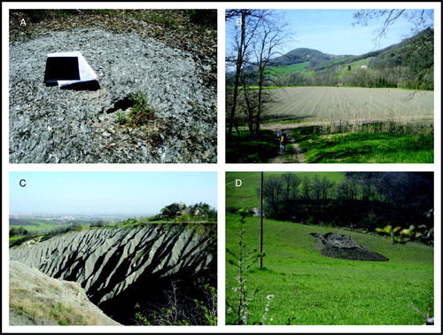
One-third of the map is characterised by fluvial morphologies, mainly related to the Idice River and, in a minor way, to its tributary Rio Olmatello. Four generations of river terraces have been mapped (, the most extensive being the second, probably of Mid Holocene age, followed by the fourth of historical age. River terraces two to four extend over an altitudinal range of approximately 20 metres. The oldest first order terrace is located between 70 and 90 metres above the present thalweg and is probably of Middle Pleistocene age (CitationPicotti & Pazzaglia, 2008). These terraces reflect both climatic changes (cold periods corresponding to aggradation and warm periods to incision) (CitationWegmann & Pazzaglia, 2009) and tectonic uplift of the Apennine front at an average rate of 1 mm a−1 (CitationPicotti & Pazzaglia, 2008).
The Rio Olmatello, a small tributary of Idice River, has developed almost no river terraces, but forms an alluvial fan when it reaches the plain. Similar alluvial fans are formed by the small tributaries Rio Calvane (Centre) and Rio Maleto (SW). Where rivers cross easily erodible rocks, small V-shaped valleys have developed. Since most of their flanks are composed of clays and marls these are affected by frequent slope movements.
One of the most striking morphological features of the area are the badlands (, extensively developed on the clays and marls characterising almost half of the study area (CitationFarabegoli & Agostini, 2000). The badlands in the upstream part of Rio Calvane and those of Rio Abadessa (in the SE corner of the map) cover an area of almost 20 hectares each. Although no morphometric analysis has been carried out on these badlands (as this is beyond the scope of the current survey), their orientation, at least in the study area, does not appear to have preferential directions. However, badlands are better developed where active mass wasting processes and river erosion at their base are able to remove fine materials rapidly (CitationBattaglia, Leoni, Rapetti, & Spagnolo 2011).
In general soft sediments are very prone to mass movement, under the form of earth-, mud-, and debris flows (. Some of these landforms reach lengths of over 500 metres and widths of over 100, and generally rather shallow depths of only a couple of metres. Many of these are still active, although most occur in uninhabitated areas. Areas affected by diffuse slope wasting often tend to develop into badlands. On less inclined slopes or where sandy deposits prevail, solifluction phenomena are often present.
Rockfalls, too small to be mapped, are present only in the more massive gypsum deposits, on the northern flank of Castel de' Britti hill and on the western border of Idice river where it cuts through the evaporites. The gypsum outcrops are intensely modified by karst processes, with the formation of typical morphologies such as dolines, up to 500 metres in diameter, blind valleys and sinking streams (South of Castel de' Britti). Smaller landforms are rillenkarren and rinnenkarren, on the border of Idice river, and tumuli, typical epidermal landforms widespread in many Messinian gypsum areas (CitationCalaforra & Pulido-Bosch, 1999; CitationFerrarese, Macaluso, Madonia, Palmeri, & Sauro, 2003). Tumuli, the arching-up of decimetric gypsum layers forming up to 2-m diameter large bulges, are related to the cyclic dissolution and recrystalisation of gypsum crystals in the uppermost layer of the rocks, and are accompanied by other small landforms such as gypsum polygons, and pressure ridges (Macaluso et al., 2001). Some small caves, presently inaccessible, are known from the gypsum outcrop of Castel de' Britti. These are often small meandering passages with occasional water flowing on their sediment-filled floors, representing typical underground karst drainage.
Gypsum rocks have been quarried in the past, and some scars are still visible in the landscape. Major quarrying activities, however, are related to alluvium of the Idice river, and sands (‘Sabbie Gialle Fm.’) on the northern slopes of the foothills.
There is an archeological site on the fourth order river terrace west of Idice river, while the river itself has been engineered with the construction of some check-dams and lateral defences and artificial river rapids.
4. Conclusions
The geomorphological map of Castel de' Britti includes the fluvial, slope, karst and anthropic landforms that build up the landscape of this northern Apennine area. These morphologies are typical of the northern Apennines, where rivers cut the Tertiary-Quaternary deposits. The map is the final product of surveying work carried out by a group of students during their ‘Geomorphological Mapping’ course (MSc course in Geological Sciences at Bologna University). Individual maps produced by the students were compared, different observations or locations of landforms were checked and corrected and, finally, combined into a single Geomorphological Map at a scale of 1:5000. The mapping has evidenced an active climate-dependant landscape, related to erosional and depositional processes and slope movements, in a slowly uplifting region. Besides the increased details reported in this large scale map (with respect to existing maps), the surveys have identified several new small landslides, demonstrating how this area is rapidly evolving. This exercise has also shown that geomorphological mapping can be taught practically, leading students from a background on mapping (topographical maps, geological literature and geomorphological legends), to observation and mapping in the field, to produce a final, and publishable, geomorphological map.
Software
This map was produced using field surveys on which field notes, sketches and cross-sections were compiled. These drawings were then transferred into CorelDRAW before final layout was performed using Adobe Illustrator CS4.
Supplemental Material - Map
Download PDF (24.1 MB)Acknowledgements
This map is the final product of the MSc work of eight students, co-authors of this paper, carried out during the Course ‘Geomorphological Mapping’ at Bologna University, from March to May 2011. The DTM in has been prepared by Alessio Ponza.
Assistance of the ‘Parco Regionale dei Gessi Bolognesi e dei Calanchi dell'Abbadessa’ in the field is greatly acknowledged.
The detailed comments of Mauro Coltorti and two anonymous reviewers have greatly improved the quality this paper.
References
- Aldrovandi , U. 1648 . Musaeum metallicum , Bologna : Ferronius .
- Battaglia , S. , Leoni , L. , Rapetti , F. and Spagnolo , M. 2011 . Dynamic evolution of badlands in the Roglio basin (Tuscany, Italy) . Catena , 86 : 14 – 23 . Retrieved April 15, 2012, from http://dx.doi.org/10.1016/j.catena.2011.01.016
- Calaforra , J. M. and Pulido-Bosch , A. 1999 . Genesis and evolution of gypsum tumuli . Earth Surface Processes and Landforms , 24 : 919 – 930 . doi: 10.1002/(SICI)1096-9837(199909)24:10<919::AID-ESP20>3.0.CO;2-D
- Chiesi , M. , De Waele , J. and Forti , P. 2010 . Origin and evolution of a salty gypsum/anhydrite karst spring: The case of Poiano (Northern Apennines, Italy) . Hydrogeology Journal , 18 : 1111 – 1124 . doi: 10.1007/s10040-010-0576-2
- De Waele , J. , Forti , P. and Rossi , A. 2011 . “ Il carsismo nelle Evaporiti dell'Emilia-Romagna ” . In Speleologia e geositi carsici in Emilia-Romagna , Edited by: Lucci , In P. and Rossi , A. 25 – 59 . Bologna : Pendragon .
- Farabegoli , E. and Agostini , C. 2000 . Identification of Calanco, a badland landform in the northern Apennines, Italy . Earth Surface Processes and Landforms , 25 : 307 – 318 . doi: 10.1002/(SICI)1096-9837(200003)25:3<307::AID-ESP64>3.0.CO;2-Y
- Ferrarese , F. , Macaluso , T. , Madonia , G. , Palmeri , A. and Sauro , U. 2003 . Solution and recrystallisation processes and associated landforms in gypsum outcrops of Sicily . Geomorphology , 49 : 25 – 43 . doi: 10.1016/S0169-555X(02)00159-9
- Gruppo Di Lavoro Per La Cartografia Geomorfologica. (1996). Retrieved April 2012, from http://www.aigeo.it/index_file/link/quad4-1.pdf.
- IFFI. (2006). Retrieved April 2012, http://ambiente.regione.emilia-romagna.it/geologia/cartografia/webgis-banchedati/cartografiadissesto-idrogeologico.
- Lucci , P. and Rossi , A. 2011 . Speleologia e geositi carsici in Emilia-Romagna [Speleology and Karst Geosites in Emilia-Romagna] , Bologna : Pendragon .
- Marinelli , O. 1917 . Materiali per lo studio dei fenomeni carsici III: Fenomeni carsici nelle regioni gessose d'Italia . Memorie della Rivista Geografica Italiana , 34 : 263 – 416 .
- Picotti , V. and Pazzaglia , F. J. 2008 . A new active tectonic model for the construction of the Northern Apennines mountain front near Bologna (Italy) . Journal of Geophysical Research-Solid Earth , 113 : B08412 doi: 10.1029/2007jb005307
- Pignone, R., Severi, P., Martelli, L., Amorosi, A., Preti, D., Benini, A., … Farabegoli, E. (2009). Carta Geologica D'Italia – Bologna Foglio 221 della carta 1:50.000 dell'I.G.M.
- Vai , G. B. 2001 . “ Structure and stratigraphy: An overview ” . In Anatomy of an Orogen: The Apennines and adjacent Mediterranean Basins , Edited by: Vai , G. B. and Martini , P. I. 15 – 32 . Dordrecht : Kluwer Academic .
- Wegmann , K. W. and Pazzaglia , F. J. 2009 . Late Quaternary fluvial terraces of the Romagna and Marche Apennines, Italy: Climatic, lithologic, and tectonic controls on terrace genesis in an active orogen . Quaternary Science Reviews , 28 : 137 – 165 . doi: 10.1016/J.Quascirev.2008.10.006