Abstract
In this work, we analyze the spatial relationships between land-use and lithology in the wine production region of Bairrada (Portugal) and present a new lithological map (1:50,000) created for the region, highlighting the associations with specific types of land-use. The study was focused on the area of Bairrada that establishes the appellation DOC-VQPRD wines. The region shows a heterogeneous lithology and land-use and it is found that these two variables are not independent. Three different zones with characteristic land-use and geology can be distinguished in Bairrada: a western zone where aeolian sand deposits are associated with coniferous forests; an eastern zone with Precambrian and Paleozoic metasedimentary units associated with broad leaf forests; and a central zone with diversified Mesozoic and Cenozoic units in which most vineyards are placed. There is a clear association between a Jurassic marly and dolomitic unit and an occupation by vineyards, which is particularly obvious when larger vineyards are considered. The vineyards are also common when these Jurassic units are covered by relatively thin siliciclastic sediments.
Keywords:
1. Introduction
It is well known that geology (namely, lithology and geological structure), climate, hydrology, topography, among other factors, influences soil characteristics, which in turn determines land suitability for agricultural and forest uses. The promotion of some agricultural products has been achieved through the terroir, a designation developed in France that refers to an area where the natural and human features are linked with distinctive food products (CitationBarham, 2003). Geology, along with climate, topography, vegetation and soil, is one of the natural features of a region that stands for the concept of the terroir (CitationBonfante, Basile, Langella, Manna, & Terribile, 2011; CitationHugget, 2005; CitationPomerol, 1985; CitationVaudour, 2003; CitationWilson, 1998). Other regional attributes, such as plant material, cultivation technique and social features are also considered in this concept. The relation between geology and wine has been explored in several works (CitationCita, Chiesa, & Massiotta, 2001; CitationCita, Chiesa, & Grici, 2003; CitationColacicchi & Parotto, 2006; CitationMunóz, 2009; CitationPomerol, 1985; CitationVaudour, 2003; CitationWilson, 1998). However, authors do not agree on the relevance of geology to the quality of wine and it is often suggested that it plays only an indirect role (see discussion in CitationHugget, 2005).
Bairrada is a wine production region located in central Portugal (). A map delimiting the areas of wine production in Bairrada was prepared for the first time in the mid-nineteenth century by António Augusto de Aguiar (CitationMarques & Fernandes, 2009). During the following decades the Bairrada region was presented with new limits, based on administrative boundaries (municipalities and parishes), always with the intention of establishing the terrain where characteristic wines are produced (CitationMota, 1993). All of them involved some enlargement of the earliest (nineteenth century) proposal. The present day limits of the Bairrada region were legally defined at the beginning of twenty-first century (Decree-Law 301/2003, of December 4; Ordinance No. 836/2004, of July 13). Wines from this region received the appellation of DOC-VQPRD (Denomination of Controlled Origin-Quality Wines Produced in a Determined Region).
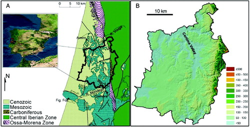
Figure 1. Regional setting of the Bairrada region. (A) Location in central Portugal and simplified geological map. (B) Digital elevation model of the Bairrada region.
The Bairrada region shows diversified geology, involving metamorphic and sedimentary rocks, which was not previously completely mapped using an adequate scale of analysis. In this work we present an original and detailed lithological map of the region and the associations that were observed between lithology and land-use patterns. The ultimate purpose of the current study is to unravel these associations in a highly heterogeneous territorial unit of wine production. To do so, an evaluation of the spatial distribution of these two variables within the region and their specific associations was carried out. The present work does not aim at an evaluation of wine quality or distinctiveness based on associations with specific lithological types nor of any other agricultural or forest products.
2. Setting
The Bairrada region, according to the legal definition from the beginning of twenty-first century, extends for 1010 km2, occupying land from the Variscan Iberian Massif (mainly with Precambrian and Paleozoic units) and the Atlantic margin (with Mesozoic and Cenozoic units) (). In physiographical terms, it includes an eastern sector of higher elevations (mainly higher than 150 m, up to 581 m) and slopes (frequently higher than 15%, reaching 78%), placed in the Variscan Iberian Massif; a western sector, in the Atlantic margin, characterized by moderate altitude (up to 200 m) and extensive platforms that slightly descend to the west (CitationAlmeida, 2009). The region's main river is the north-directed Cértima River, which crosses the region near the contact between the Variscan Iberian Massif and the Atlantic margin (). This river integrates the Vouga watershed, while the drainage in the southern and south-western sectors feed the Mondego River and coastal streams, respectively.
The regional climate is of Csb type, according to the Köppen-Geiger classification (CitationPeel, Finlayson, & McMahon, 2007). It has Mediterranean influence revealed by monthly variations of temperature and precipitation, with hot and dry summer months and cold and wet winter months. Annual precipitation is around 1000 mm and the driest and wettest months have mean precipitation of approximately 10 and 150 mm, respectively. Mean hottest and coldest months have temperatures of around 10 and 20°C, respectively. Relative air humidity is lower and less homogeneous in eastern locations, but is always higher than 60%.
No detailed soil cartography is available for the studied area. A 1:1,000,000 map (CitationCardoso, Bessa, & Marado, 1973) shows podzols, mainly in western locations, and cambisols, in central and eastern locations, as the most common soil types in the Bairrada region. In this map, fluvisols are almost absent, but they are expected to occupy a significant part of the wider valley bottoms.
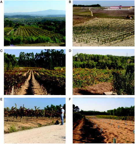
At least since the Roman period, the Bairrada region has been an agricultural area where the production of wine was shared by olive and cereals with the latter concentrated in the most fertile soils of lower elevation and closer to the streamlines (CitationMota, 1993). Classically, it reveals an occupation fabric characterized by smallholding, particularly in the most fertile soils (CitationGaspar, 1970; CitationMota, 1993). The classical smallholding occupation associated with the need to protect crops from coastal winds justify that, particularly in western locations, the vineyards occur in relatively small patches interspersed with forests and orchard (). The region is crossed by the railroad and several main roads that link the north and the south of Portugal. It is presently an area with mixed rural and urban features in the transition between the main urban centers of Aveiro (to the north) and Coimbra (to the south).
Figure 2. Images of the Bairrada region. (A) General eastward view of Bairrada with vineyards in the Atlantic margin and Cértima valley intermixed with other agricultural and forest occupation; eastern reliefs at the back. (B) Extensive vineyard in Jurassic units. (C) Vineyards along slightly dipping slopes on ‘Jurassic marly and dolomitic carbonates’; at the top of gentle hills the Jurassic units are covered by ‘Sand-gravel coastal sediments’ where coniferous forests tend to develop. (D) Small patches of vineyards inter-mixed with forest and olive occupation. (E) Vineyards in thin ‘Sand-gravel coastal sediments’ that cover ‘Jurassic marly and dolomitic carbonates’. (F) Recent replacement of vineyards by coniferous forests.
3. Methods
An original lithological map with homogeneous units was created for this study. It partially evolved from previously published maps that cover the Bairrada region. We used sheets of the 1:50,000 Geological map of Portugal (CitationBarbosa, 1981; CitationBarbosa, Soares, Rocha, Manuppela, & Henriques, 1988; CitationTeixeira & Zbyszewski, 1976), the geological sketches prepared for the municipality of Coimbra (CitationTavares, 1999), Cértima Valley (CitationCourbouleix, 1972; CitationDinis, 2004) and the Coastal Platform north of Águeda River (CitationGomes, 2008). Because these maps were produced for different purposes, the represented units were based on distinct attributes (chronostratigraphy, lithostratigraphy and other lithic features with relevance for land-planning or geomorphology). Hence, the content of the units that are mapped in those documents, and the limits between them, are not coincident and it was necessary to produce a new map, substantially simplified that is able to represent the lithologic-homogeneous units that might constrain the land-use of the region, removing other information. To complete the cartography of the region it was also necessary to map the adopted lithologic units in a substantial part of the area that was not previously covered in preceding works. The area was field surveyed at a scale of 1:25,000 using the topographic base maps of the Portuguese Army Geographic Institute (IGeoE). The final lithological map was created at a scale of 1:50,000 and later represented in vector form.
The land-use representation was based on the classification and representation of CORINE land cover biotopes (CitationBossard, Feranec, & Otahel, 2000). Corine maps of 2000, 2006 and 2010 were considered for the present study. The Corine representations were later ground truthed during field surveys by driving through the Bairrada region with GPS-navigation, allowing a continuous analysis of the land-use coverage and noting recent transformations.
The computation of the areas that share different combinations of lithologic and land-use units, and their spatial distribution, were used to establish the associations between these two variables. Associations were obtained from lithology and land-use vector data in geographic information system software and then statistically tested through contingency tables.
4. Lithology and land-use
4.1. Lithology
Given the location of Bairrada region, extending through the Portuguese Atlantic Margin and the Variscan Iberian Massif, it shows diversified lithology that comprises pelitic and siliceous metamorphic rocks and siliciclastic and carbonate sedimentary units. At a first level of analysis, lithologic units were organized in to three groups: ‘Cenozoic sediment cover’, ‘Mesozoic sedimentary rocks’ and ‘Precambrian-Paleozoic metamorphic and sedimentary rocks’ ().
Table 1. Characteristics of the lithologic units of the Bairrada region.
The ‘Cenozoic sediment cover’ integrates units of Pliocene to Holocene age that are friable, sub-horizontal and, in most cases, relatively thin. This group includes: (1) alluvium, (2) aeolian sand deposits, (3) terrace deposits, (4) sand-gravel coastal sediments and (5) gravel-mud continental sediments.
The ‘Mesozoic sedimentary rocks’ integrates diverse carbonate and siliciclastic rocks with different states of consolidation. For practical reasons, the large number of Mesozoic formations that were defined in previous works were organized in the following lithologic units: (1) Cretaceous mudstones, (2) Cretaceous siliciclastics and carbonates, (3) Jurassic limestone, (4) Jurassic marly and dolomitic carbonates and (5) Triassic-Jurassic siliciclastics. The lower Jurassic dolomitic formations (integrated in the ‘Jurassic marly and dolomitic carbonates’) and the Cretaceous carbonate units (integrated in the ‘Cretaceous siliciclastics and carbonates’) were not shown due to representation difficulties at the selected scale and because they were considered less relevant for the purposes of the present work.
The Paleozoic and Precambrian units are constituted mainly of metapelites and quartzites with diverse structural arrangements. The following units were considered: (1) Carboniferous siliciclastics, (2) Ordovician-Silurian quartzites and metapelites, (3) Precambrian metapelites of Central Iberian Zone (CIZ), (4) Precambrian-Paleozoic metapelites of Ossa Morena Zone (OMZ).
The ‘Cenozoic sediment cover’, ‘Mesozoic sedimentary rocks’ and ‘Precambrian-Paleozoic metamorphic and sedimentary rocks’ have a spatial frequency of 54.7%, 32.1% and 13.0%, respectively. The ‘Sand-gravel coastal sediments’ (25.1%) and the ‘Cretaceous siliciclastics and carbonates’ (14.1%) are the most common units in the region. The Palaeozoic to Precambrian units are restricted to an eastern fringe of up to 3 km width. The majority of the ‘Aeolian sand deposits’ are located in SW locations of the region.
4.2. Land-use
The field surveys indicated that some small patches, particularly in the proximity of discontinuous urban areas, were misrepresented in the Corine maps. Some of the problems of representation are attributed to generalization processes used in the Corine land cover (CitationBossard et al., 2000). The replacement of some agricultural uses (namely vineyards) by forest uses is also seen at several locations (). Regardless of these facts, the land-use coverage from Corine 2000 was considered the most adequate for the purposes of the present work since it is able to represent the pattern of land-use without excessive fragmentation and does not reflect recent changes raised by social or economic factors (e.g. replacement of agricultural land by forest and industrial uses).
The land cover types in the Bairrada region are represented in . The most frequent types of land-use are the ‘Agricultural areas’ (45.5%) and the ‘Forests and semi-natural areas’ (49%). The ‘Artificial surfaces’ represent only 5% of the Bairrada, while the ‘wetlands’ and ‘water bodies’ are merely residual.
Table 2. Types of land-use throughout the Bairrada region: Land-use is organized into three levels according to Corine 2000.
Among the ‘Agricultural areas’, the ‘Complex cultivated patterns’ is the most common form of land-use (18.9%). This form of occupation is characterized by small parcels of diverse annual crops, pasture and/or permanent crops (CitationBossard et al., 2000). It appears distributed fairly uniformly throughout the region, but is especially common in the vicinity of villages or ordered following the dispersed settlements along main roads and the railway. ‘Vineyards’ are found in only 12% of the region.
The ‘Forests and semi-natural areas’ are represented by the following types of occupation (level 3): ‘Broad-leaved forest’ (10.5%), mainly in eastern realms; ‘Coniferous forest’ (18%), mainly in the southwest part; and ‘Mixed forest’ (16%), frequent at the transition strip between the eastern part of Bairrada and the Cértima valley, but also found scattered westward of this river.
4.3. Relationships between land-use and lithology
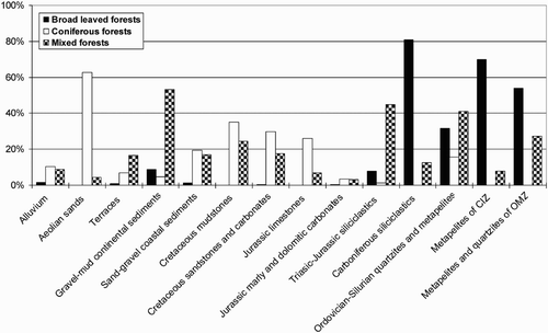
The Bairrada region has a diverse and contrasting lithology that is reflected in some agricultural practises and forest land-use (). ‘Agricultural areas’ are particularly common in the ‘Alluvium’ and ‘Jurassic marly and dolomitic carbonates’ along the central zone of the region, while ‘Forests and semi-natural areas’ are particularly common in eastern and western locations. In eastern locations, associated with Precambrian and Paleozoic formations, ‘Broad-leaved forests’ predominantly occur, whereas in western locations, ‘Coniferous forests’ are primarily associated with ‘Aeolian sand deposits’. ‘Mixed forests’ are especially common in the ‘Gravel-mud continental sediments’ and ‘Triassic-Jurassic siliciclastics’ that underlie the contact zone between the Variscan Massif and the Atlantic margin ().
Table 3. Spatial representation of the possible combinations of lithology and land-use.
Figure 3. Percentage of occupation by the three types of forests (coniferous, broad leaved and mixed) in the different lithologic units.
4.3.1. Vineyard-lithology association
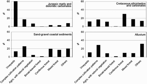
The frequency of ‘Agricultural areas’ in the ‘Jurassic marly and dolomitic carbonates’ is promoted by the association of the vineyards with this lithologic unit. In fact, 42% of the vineyards are placed in the ‘Jurassic marly and dolomitic carbonates’ () and, when just 12% of the Bairrada region have vineyards, 61% of this Jurassic unit shows vineyards (). The vineyards are also very common when relatively thin ‘Sand-gravel coastal sediments’, ‘Cretaceous siliciclastics and carbonates’ and ‘Alluvium’ cover that Jurassic unit (). However, when considering the different land-use types found within each lithologic unit, the proportion of vineyards in these three units is relatively low (11–13%), being supplanted by other types of land-use, such as ‘Coniferous forest’ and ‘Complex cultivation patterns’ (). The association ‘Vineyards’ – ‘Jurassic marly and dolomitic carbonates’ is reinforced when only the larger vineyards areas are considered. In fact, the majority of the larger vineyard areas (52 % of vineyards >200 ha) are placed in this Jurassic unit ().
Figure 4. Distribution of vineyards in the different lithologic units. Black bars for all vineyards and white bars for patches larger than 200 ha. Gravel-mud cont. sed.: Gravel-mud continental sediments; Sand-gravel coastal sed.: Sand-gravel coastal sediments; Cret. Sandstones and carb.: Cretaceous siliciclastics and carbonates; Jur. marly and dolomitic carb.: Jurassic marly and dolomitic carbonates.
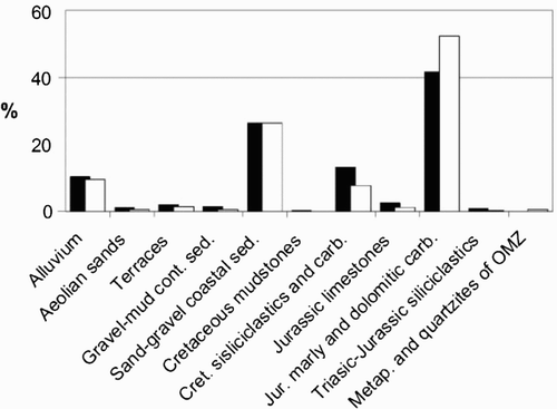
Figure 5. Proportion of distinct land-use types within the four lithologic units where most vineyards occur.
4.3.2. Statistical validation
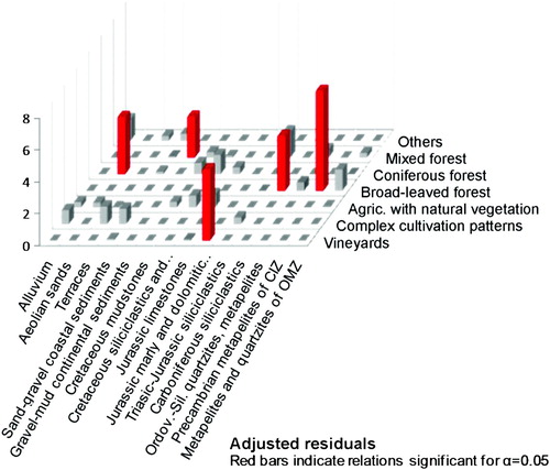
A contingency table was created from the observed and expected frequencies computed for each combination of lithology and land-use forms. The χ2 test applied to this contingency table indicates that these two variables are not independent (X2 obs = 106.1 > X2 0.05, (13-1), (7-1) =99.6). Given this result, adjusted residuals were determined to confirm the associations between specific types of lithology and soil use. Adjusted residuals are computed by:
The following combinations were confirmed as statistically significant (α = 0.05; ):
| • | ‘Vineyards’ – ‘Jurassic marly and dolomitic carbonates’ | ||||
| • | ‘Broad-leaved forests’ – ‘Precambrian-Paleozoic metapelites’ and ‘Carboniferous siliciclastics’ | ||||
| • | ‘Coniferous forest’ – ‘Aeolian sand deposits’ | ||||
| • | ‘Mixed forests’ – ‘Mud-gravel continental sediments’ | ||||
Figure 6. Adjusted residuals for possible associations between lithology and land-use.
Regardless of the presence of these statistically valid associations, the different forms of forest occupation are probably not directly imposed by lithology. The higher slopes and thinner soils in eastern locations could explain the dominance of board leaved forests, whose implantation in central Portugal, in particular in areas less suitable for agricultural uses, has been grown rapidly during the last decades. Coniferous forests are historically present in the Portuguese coastal region, playing a defense role against maritime winds. The frequency of ‘vineyards’ in ‘Jurassic marly and dolomitic carbonates’ may be related to the presence of a specific soil type. In fact, although the available soil map is inadequate for a detailed analysis, a significant part of this lythological unit is distinguished within the central part of Bairrada region by the presence of calcic cambisols (CitationCardoso et al., 1973).
7. Conclusions
In this study we present a lithological map of the Bairrada region designed to explore and highlight the spatial associations between lithology and different forms of land-use. The Bairrada region is found to be quite heterogeneous in terms of lithology and land-use. The lithology and land-use forms found in the eastern and western sectors of the Bairrada resemble the neighboring regions: (1) in the western sector Quaternary aeolian sand sediments are mainly occupied by coniferous forests; (2) in the eastern sector Paleozoic and Precambrian metamorphic and sedimentary rocks dominate and the land-use is mainly broad-leaved forest. Vineyards are particularly uncommon in these sectors. The central zone, with high lithologic and land-use heterogeneity, reveals higher proportions of agricultural uses (especially the ‘Complex cultivation patterns’ and ‘Vineyards’). Vineyards appear to be unevenly distributed, exhibiting strong association with the ‘Jurassic marly and dolomitic carbonates’. They are also frequent in western Bairrada, in an extensive zone where these Jurassic rocks are covered by the fairly thin ‘Sand-gravel coastal sediments’ (Pliocene-Pleistocene aged) and by ‘Cretaceous siliciclastics and carbonates’. The transition between the Variscan Massif and the Atlantic margin is frequently marked by the presence of ‘Gravel-mud continental sediments’, where the ‘Mixed forest’ is particularly common.
Strong associations found between lithologic and land-use units probably arise from inherited agricultural experience of several generations. Others reflect physiographic features which, in turn, must be directly related to geology. Although the observed relations cannot support value judgments about any resources, the association ‘Vineyards’ – ‘Jurassic marly and dolomitic carbonates’ should be considered when evaluating the proprieties of the wine that receive the label of origin. The produced lithological map and the aforementioned associations should guide research on constraining the influence of different environmental features on the quality of wine and other agricultural products. It can also be a helpful tool for detailed mapping of the region soils.
Software
Lithology and land-use maps were processed and edited in Esri ArcGis 10. Esri ArcPad was used to survey the region and validate the land-use map. Contingency tables and adjusted residuals were determined using XLSTAT.
Supplemental Material - Map
Download PDF (6.4 MB)Acknowledgements
The authors are grateful to the reviewers Vaudour and Townsend and the editors Riccomini and Smith for their comments and suggestions that helped to improve the text and map.
References
- Almeida , J. P. 2009 . Caracterização física da região da Bairrada: Contribuição para a valorização dos recursos endógenos [Physical characterization of the Bairrada region: contribution to an improvement of endogenous resource]. MSc thesis, University of Coimbra
- Barbosa , B. P. 1981 . Notícia Explicativa da Folha 16-C (Vagos) da Carta Geológica de Portugal na escala 1/50000 [Explanatory Note of the Sheet 16-C (Vagos) of the Geological Map of Portugal, scale 1/50000]. Serviços Geológicos de Portugal
- Barbosa , B. P. , Soares , A. F. , Rocha , R. B. , Manuppela , G. and Henriques , M. H. 1988 . Notícia Explicativa da Folha 19-A (Cantanhede) da Carta Geológica de Portugal na escala 1/50000 [Explanatory Note of the Sheet 19-A (Cantanhede) of the Geological Map of Portugal, scale 1/50000]. Serviços Geológicos de Portugal
- Barham , E. 2003 . Translating Terroir: The global challenge of French AOC labeling . Journal of Rural Studies , 19 : 127 – 138 .
- Bonfante , A. , Basile , A. , Langella , G. , Manna , P. and Terribile , F. 2011 . A physically oriented approach to analysis and mapping of terroirs . Geoderma, 167–168 , : 103 – 117 .
- Bossard , M. , Feranec , J. and Otahel , J. 2000 . CORINE land cover technical guide - Addendum 2000 (Technical Report No. 40) , Copenhagen : European Environmental Agency .
- Cardoso , J. C. , Bessa , M. T.E. and Marado , M. B. 1973 . Carta dos Solos de Portugal (1:1,000,000) [Map of the Soils of Portugal (1:1,000,000)] . Agronomia Lusitana , 33 : 481 – 602 .
- Cita , M. B. , Chiesa , S. and Grici , G. M. 2003 . Geologia dei Vini Italiani. Italia Meridionale e Insulare [Geology of Italian Wines. Southern Italy and Islands]. BE-MA editrice
- Cita , M. B. , Chiesa , S. and Massiotta , P. G.M. 2001 . Geologia dei Vini Italiani. Italia Settentrionale [Geology of Italian Wines. Northern Italy]. BE-MA editrice
- Colacicchi , R. and Parotto , M. 2006 . Geologia dei Vini Italiani. Italia Centrale [Geology of Italian Wines. Central Italy]. BE-MA editrice .
- Courbouleix , S. 1972 . Etude geologique des regions de Anadia Mealhada, au Nord de Coimbra (Portugal) [Geological Study of regions of Anadia Mealhada, north of Coimbra (Portugal)]. Mem. Faculte des Sciences, Universite Lyon
- Dinis , P. 2004 . Evolução pliocénica e quaternária do vale do Cértima [Pliocene and Quaternary Evolution of Cértima Valley]. PhD thesis, University of Coimbra
- Gaspar , J. 1970 . “ As feiras de Gado da Beira Litoral [Cattle fairs of Beira Litoral] ” . Centro de Estudos Geográficos da Universidade de Lisboa, p. 187 .
- Gomes , A. 2008 . Evolução Geomorfológica da Plataforma Litoral entre Espinho e Águeda [Geomorphological Evolution of the Littoral Platform between Espinho and Aveiro]. PhD thesis, University of Porto
- Hugget , J. M. 2005 . Geology and wine: A review . Proceedings of the Geologists' Association , 117 : 239 – 247 .
- Marques , H. and Fernandes , M. G. 2009 . Cartografar para compreender. A viticultura portuguesa da difusão da filoxera à estruturação da rede de adegas cooperativas pela Junta Nacional do Vinho [Mapping to understand. The Portuguese viticulture from the spread of phylloxera to structuring the network of cooperatives by the National Wine Board]. III Simpósio Luso-Brasileiro de Cartografia Histórica
- Mota , A. 1993 . Estudos regionais sobre a Bairrada [Regional studies on Bairrada]. Figueirinhas
- Munóz , A. 2009 . Geologia y Vinos de España [Geology and Wines of Spain]. ICOG .
- Peel , M. C. , Finlayson , B. L. and McMahon , T. A. 2007 . Updated world map of the Koppen-Geiger climate classification . Hydrology and Earth System Sciences , 11 : 1633 – 1644 .
- Pomerol , C. 1985 . “ Terroirs et vins de France: Itinéraires Enologiques et Géologiques. [Terroirs and wines of France. Enological and Geological routes] ” . Editions BRGM
- Tavares , A. M.O.S. 1999 . Condicionantes Físicas ao Planeamento. Análise da susceptibilidade no espaço do concelho de Coimbra [Physical Constraints to Planning. Analysis of the susceptibility within the municipality of Coimbra]. PhD thesis, University of Coimbra .
- Teixeira , C. and Zbyszewski , G. 1976 . Notícia Explicativa da Folha 16-A, Aveiro da Carta Geológica de Portugal na escala 1/50000 [Explanatory Note of the Sheet 16-A (Aveiro) of the Geological Map of Portugal, scale 1/50000]. Serviços Geológicos de Portugal
- Vaudour , E. 2003 . Les terroirs viticoles [The wine terroirs] . Dunod ,
- Wilson , J. E. 1998 . Terroir: The role of geology, climate and culture in the making of French wine . Mitchell Beazley ,