Abstract
This work presents a geo-hiking map of Mt. Penna and Mt. Aiona area (Aveto Natural Park, Italy), an original and useful tool in the Earth science mapping field. Aveto Park is one of the best known Italian protected areas; it is located in the Ligurian Apennines and belongs to the Ophiolitic Protected Areas Coordination (‘C.A.P.O.’) and to the European Ecological Network Nature 2000. The Park area is crossed by more than 500 km of paths and trails where hikers, climbers and mountain lovers walk every year.
The geo-hiking map was compiled by combining available geological and geomorphological bibliographic data with a field survey and basic information derived from hiking and tourist maps. The main stages used for production of the map are as follows: (a) bibliographic and map research of scientific papers; (b) a geological and geomorphological field survey; (c) trail and route data from tourist park maps; (d) research of geotouristic elements of interest.
This work shows an example of geocartography research that really contributes to the implementations of documents and maps useful in the hiking tourism field. The main map is complemented with a natural hazard map; increasing tourism during the whole year in areas with geomorphological hazards results in a relationship between the human element, natural processes and hazard phenomena.
1. Introduction
Geotouristic maps are today acknowledged as useful tools for the recognition and preservation of geodiversity of regional, coastal or mountain landscapes, particularly national parks (CitationCastaldini, Valdati, Ilies, Chirian, & Bertogna, 2005; CitationRegolini-Bissig & Reynard, 2010; CitationSerrano & Gonzalez Trueba, 2011).
As with other thematic maps, geotouristic maps show: (a) the main geologic and geomorphologic features of the landscape (CitationGoodenough, Pickett, Krabbendam, & Bradwell, 2004; CitationCoratza & Regolini-Bissig, 2009; CitationSapp, Miro, & César, 2006); (b) the trail network, the geodiversity value and basic tourist information (CitationCastaldini, Valdati, & Ilies, 2009; CitationMartin & Reynard, 2009).
Geo-hiking maps show those landscape elements recognizable by tourists and indicate how possible hazards could interfere with the hiking paths; this allows users better understanding of the geological and geomorphological features of the surrounding landscape, also to raise hikers' awareness both of the characteristics of the trail and natural hazards (CitationCoratza, Ghinoi, Piacentini, & Valdati, 2008; CitationCutter, 1996).
This paper presents a geo-hiking map of the Mt. Penna and Mt. Aiona area in the Aveto Natural Park, located in Italy's Ligurian Apennines (); the protected area is well known internationally for its unusual geological and geomorphological, features.
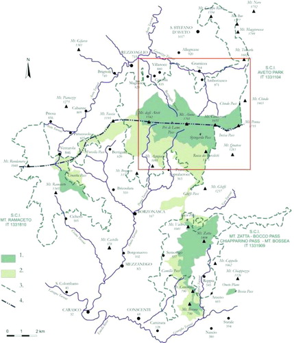
Figure 1. Geographic map of Aveto Natural Park: (1) Protected area; (2) Adjacent area; (3) Boundary of site of UE interest; (4) Main watershed. The red square shows the geo-hiking map area.
Although the southern parts of Aveto Natural Park are less than 20 km from the sea, the physical-geographical conditions of this area are more like an Alpine environment than a typical Ligurian coastal hinterland. The geomorphological processes and climatic conditions of this area involve several natural hazards, such as rock falls, debris flows, avalanches, heavy rainfall, snowfall and strong winds.
In an environment with increasing impact from tourists, other factors may contribute to increased geomorphological risk (e.g. vulnerability raised by trail features and human factors and behaviour). Data collected by the Italian Alpine and Speleological Rescue Corps between 1996 and 2010 in Aveto Natural Park show an average of more than three rescues per year.
This study represents a useful tool for responsible tourism in mountain areas: the geo-hiking map combines geodiversity elements of the geological and geomorphological landscape with the main natural hazards which characterize the same territory.
2. Environmental geological cartography
This work was organized through bibliographic and cartographic research (), field surveys, aerial photo-interpretation and geologic-geomorphologic mapping.
Table 1. Main existing scientific literature on the Mt. Penna and Mt. Aiona area, objective of the previous study and the thematic area where the information has been applied. References: (1) AA.VV. (1988); (2) CitationBeccaluva, Gallo, Piccardo, Vernia, and Zanzucchi (1980a); (3) Beccaluva, Piccardo, and Serbi (1980b): (4) CitationBellinzona, Boni, Braga, Casnedi, and Marchetti (1968); (5) CitationBoni et al. (1969); (6) CitationBottino, Campomenosi, and Cresta (2006); (7) CitationBraggio Morucchio and Guido (1975); (8) CitationBrandolini, Faccini, Robbiano, and Terranova (2008); (9) CitationCasnedi, Galbiati, Gallo, Vernia, and Zanzucchi (1983); (10) CitationCasnedi et al. (1993); (11) CitationCasnedi (1982); (12) CitationConti, Marcucci, and Zanzucchi (1988); (13) CitationElter, Marroni, Molli, and Pandolfi (1991); (14) CitationFanucci and Nosengo (1977): (15) CitationLosacco (1940); (16) CitationLosacco (1949); (17) CitationLosacco (1982); (18) CitationMarini and Terranova (1975); (19) CitationMarini and Terranova (1979); (20) CitationMarini and Terranova (1980a); (21) CitationMarroni and Perilli (1990); (22) CitationMontanari (1987); (23) CitationMontanari, Guido, and Braggio Morucchio (1982); (24) CitationMontanari and Guido (1983); (25) CitationParco Naturale Regionale dell'Aveto (2005); (26) CitationPerotti, Savazzi, and Vercesi (1988); (27) CitationPiccardo (1983); (28) CitationRampone (1987); (29) CitationRampone et al. (1995); (30) CitationRegione Liguria (1994); (31) CitationRegione Liguria (2005a); (32) CitationRegione Liguria (2005b); (33) CitationRoccati (2011); (34) CitationSacco (1893); (35) CitationSacco (1937); (36) CitationServizio Geologico Italiano (1968); (37) CitationTerranova (1964); (38) CitationTerranova and Zanzucchi (1981); (39) CitationTerranova (1987); (40) CitationVan Wamel (1987).
All collected data were utilized to produce geo-hiking cartography, summarized in two thematic maps: the main map, related to geo-tourist cartography, and the natural hazard map.
2.1. Environmental geography features
Mt. Penna and Mt. Aiona lie in the Aveto Park (Ligurian Apennine) and represent the most important and famous part of the protected area. It was established in 1989 by law and is divided into Natural Park Areas (30 km2) and Adjacent Areas (27 km2).
It is part of the Ophiolitic Protected Areas Coordination and the European Ecological Network Nature 2000, which were set up to protect the most endangered habitats and species in optimal wildlife areas, including the Sites of UE Interest (‘Siti di Interesse Comunitario’). This area is also a Site of UE Interest ‘Parco dell'Aveto’, which was recently botanically and environmentally studied (CitationBranch, 2004).
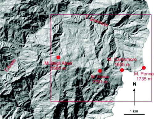
The park area extends along the Tyrrhenian Sea-Po River watershed in the Upper Aveto Valley and covers wide sectors of the Graveglia and Sturla Valleys maritime slopes (). In particular, the mountain ridge of Mt. Penna (1635 m), Mt. Cantomoro (1655 m), Mt. Aiona (1701 m) and Mt. degli Abeti (1542 m) cover the north-eastern part of the Sturla stream catchment on the maritime slope and most of the Rezzoaglio and Gramizza stream catchments on the northern slope.
Figure 2. Digital Elevation Model of the studied area (25 m × 25 m resolution). The red square shows the geo-hiking map area.
The orographic setting of this sector, where the southern slopes of the mountain ridge face S and the northern slopes face N-NE, affects the winds and air current direction, and therefore the rainfall supply: when humid air from the sea meets colder and drier air from north, the climate conditions cause frequent, and occasionally heavy, precipitation.
The climatic characteristics of the Mt. Penna and Mt. Aiona area were determined by analyzing temperature and precipitation data recorded in the 1951–2010 period at several weather stations in the Upper Aveto Valley and surrounding areas (). Annual mean rainfall ranges from 1350 mm/y at Boschi d'Aveto to 2400 mm/y at Casermetta del Penna; rainfall increases with altitude. Precipitation is evenly distributed throughout the year, with maximum rainfall in the Autumn and minimum rainfall in the Summer.
Figure 3. Isohyet (a, mm) and isotherm (b, °C) maps and climate diagram (below) for the Upper Aveto Valley, 1951–2010.
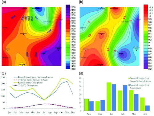
The annual mean temperature is about 10°C, with limited temperature ranges. The distribution of isotherms has its maximum in the valley floor and decreases with altitude. In the winter, the temperature and wind together cause a ‘wind-chill’ effect.
The amount of rainfall also depends on condensation caused by significant temperature difference between the air, which is saturated with water vapour, and the rock mass discontinuities near the ridge, in addition to snowfall between December and March.
The annual mean snowfall is more than 100 cm; the thickness and duration of snow cover on the ground changes in value according to altitude and slope aspect. The direct flow of humid air from the sea rapidly melts the snow cover on those slopes facing warm winds blowing from the south, while on northern slopes and in small canyons snow can remain until late spring. Local anabatic and katabatic winds, which originate close to the relief, help fuel precipitation.
The ridge positions of Mts. Penna, Aiona and degli Abeti cause particular climatic conditions featuring low-altitude cloud and thick fog, sudden changes in weather, storms and heavy snowstorms and gales in the late autumn and winter.
2.2. Geotourist features
The geotourist map was derived, with generalisation, from the geologic and geomorphologic map, and combines the most significant geodiversity values with basic hiking and tourist information.
The information derived from surveys, maps and bibliography has been separated into three themes: trails and routes; elements of geotourist interest; geological and geomorphological data.
2.2.1. Trails and routes
The main excursion trails in the Aveto Park area include the following: the High Route of the Ligurian Mountains (‘Alta Via dei Monti Liguri’), the path network of the Italian Alpine Club (Club Alpino Italiano) and Italian Hiking Federation, and several thematic and hiking routes promoted by the Park Organization (Parco Naturale Regionale Aveto, 2005). In particular, the Mts. Penna-Aiona-degli Abeti area comprises a number of paths with different structural features, lengths and degrees of difficulty and cross several morpho-climatic environments ().
Figure 4. Hiking map of Mt. Penna and Mt. Aiona area; (1) High route of the Ligurian Mountains; (2) Hiking federation path symbol (example); (3) Trekking route of Aveto Natural Park; (4) Road (a), dirt road (b).
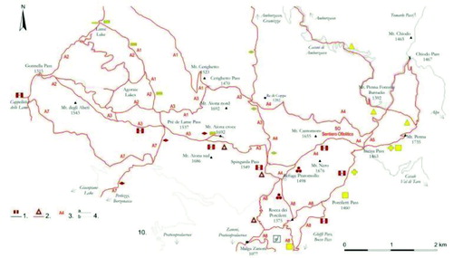
These paths start from the valley floor and go uphill to the ridge, reaching their maximum on the peaks of Mt. Penna (1635 m) and Mt. Aiona (1701 m). These paths are in a few cases dirt roads, flat or very gentle, whereas along the ridge and near the peaks they become narrow trails, locally very steep and exposed, occasionally equipped with chains and wire ropes (e.g., Mt. Penna northern slope).
There are also some geo-thematic trails which illustrate particular Earth science features, such as the Ophiolitic Trail of Mt. Cantomoro.
The entire area of Mt. Penna and Mt. Aiona is frequented by both hikers and climbers, who walk along the numerous paths mainly between May and October, and visitors attracted by the natural environment and landscape, who can easily reach the paths from the communication routes. There are also people practicing various sports such as horse riding and mountain bike trekking, cross-country skiing, ski-touring, snowshoe trekking, rock wall and frozen waterfall climbing, stream climbing and canoeing. The practice of these sports has significantly increased in recent years, and as a result, this area is increasingly frequented throughout the year.
2.2.2. Elements of geotourist interest
The Aveto Park shows different elements of geotourist interest, briefly summarized as geobotanic, mineralogical and petrographic, geomorphological and geological.
The geobotanic interest (also known as ‘phytogeography’) is related to the well-known wet zones on the northern slope, characterized by three series of morphological plain connected by steep scarps. The first plain is located at 1300 m a.s.l. and collects the more significant lakes: the Lago degli Abeti, the Pozza degli Abeti, the Laghi Agoraie di Sopra, di Mezzo, di Fondo, the Lago Riondo, the Lago Lagastro.
A second plain is around 1270 m and contains the Laghi delle Asperelle and dei Fracci ponds, while the third plain is located at 1030 m a.s.l., just below the Lago delle Lame closed depression, and contains the Lago della Gavazza, Lago del Corvo, Lago della Polenta and Lago Scuro ponds. On the southern slope there's the lacustrine depression of Prato Mollo, the largest within the area of study and certainly the best known of the Ligurian Apennines. These wet zones, almost always recognized in the scientific literature as glacial landforms, are actually identified as closed depressions filled with lacustrine deposits related to deep-seated gravitational slope deformations (CitationRoccati, 2011).
Mineralogic and petrographic interest is related to ophiolitic bedrock which characterizes the landscape of this Ligurian Apennines area: the peridotite masses outcrop near the Mt. Aiona alpine hut are upper mantle slabs, probably the most ancient rocks of Mediterranean area. Absolute geochronological data, based on isotope systematic dating, indicate an approximate age of two billion years.
The peridotite mineralogic associations are visible to the naked eye: the pirossenitic bandings are easy to recognize in relief and the olivine levels more eroded. Close to these masses the compass needle is influenced by magnetite presence, as in the Pria Borghese site case at Prato Mollo.
The pillow basalt outcrops contain a concentric zone characterized by different rock composition: the narrow external part is a glassy rock, while the internal core contains crystals of increasing size, such as plagioclase, clinopyroxene and olivine. On the outer surface and proceeding inward, reddish halos are formed from oxides and hydroxides, while the discontinuities within the rock mass are often filled with calcite.
Geologic and geomorphologic features of interest are related to the remarkable geodiversity of this part of the Apennines, characterized by ophiolitic rock mass and sedimentary cover, and by slope geomorphological landforms and processes due to running water, gravity and periglacial activity.
2.2.3. Geological and geomorphological data
The Aveto Natural Park area features a complex geological setting () with turbidite deposits, ophiolitic and ultrabasic masses associated with heterogeneous breccias and olistolithes, detached from their original bedrock, known in the literature as the ‘Mt. Penna-Mt. Aiona Complex’ (CitationCasnedi, Galbiati, Vernia, & Zanzucchi, 1993; CitationRegione Liguria, 2005a, Citation2005b). Sandy shale flysch outcrops on the south-western end are related to Mt. Gottero Tectonic Unit (CitationVan Zupthen, Van Wamel, & Bon, 1985).
Figure 5. Geologic and Geomorphologic map; (1) Serpentinites and peridotites; (2) Serpentinitic breccias; (3) Basalts; (4) Polygenetic breccias; (5) Cherts; (6) Granites; (7) Ophiolitic sandstones; (8) Shales with limestone layers; (9) Clayey marls; (10) Marly limestones; (11) Siltstones and sandstones; (12) Periglacial deposits; (13) Gravity deposits; (14) Faults, certain (a) or assumed (b); (15) Overthrust; (16) Polygenetic fan; (17) Edge of degradation or landslide scarp. Top left: Tectonic Unit map (Citation1 Mt. Gottero; Citation2 Ottone; Citation3 Mt. Aiona; Citation4 Mt. Orocco; Citation5 Canetolo; Citation6 Aveto).
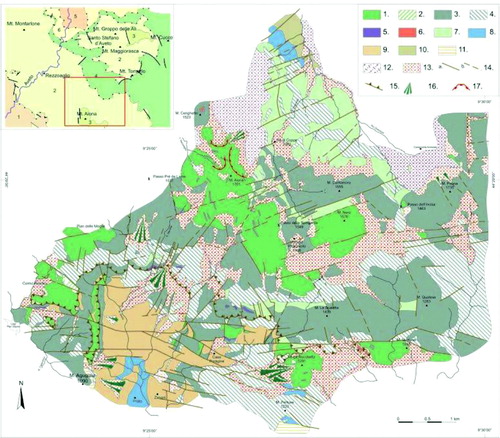
Ultramafic olistolithes and olistostromes tens of metres in size outcrop in the Mt. Aiona area (CitationMarini & Terranova, 1980a, Citation1980b); they are composed of, from bottom to top, ultramafic rocks, basalts and basaltic breccias, ophiolitic breccias, ophiolitic sandstone and small granitic masses (Aiona Subunit). This sequence appears to be overturned along the northern slope and the Mt. Aiona peak. Ultramafic rocks form the upper part of Mt. Aiona (CitationPiccardo, Rampone, & Vannucci, 1992; CitationRampone & Piccardo, 2000): they rest in part on basalts, often associated with serpentinitic breccias, and in part on sedimentary deposits of the Casanova Complex with discordant geometric relationships.
Pillow olistolithes tens of metres in size and massive basalts outcrop in the Mt. Penna and Mt. Cantomoro area, often associated with basaltic breccias as well as altered and fractured granites (CitationTerranova & Drago, 1975).
A chaotic complex composed of ophiolitic sandstones, mono- and polygenic breccias with clayey or sandy cement and ultramafic olistolithes outcrops along the orographic left of the S. Gramizza (Casanova Complex), associated with shales intercalated with olistostromes lens with limestones and a clayey shaley matrix, polygenic breccias and ophiolitic masses (Mt. Veri Shales); marls, marly limestones and clayey marls, occasionally with argillitic and sandy layers, can be found in the northern parts (Ottone Flysch).
The Mt. Penna-Aiona Complex is separated from the underlying unit, which is more heterogeneous and complex, by a tectonic surface dipping slightly to N-NE.
The main tectonic lineations are approximately orthogonal to one another; two systems can be distinguished, oriented NE-SW and E-W, respectively that formed as a result of later deformation stages. The drainage patterns, which are usually very short and steep, follow these tectonic lineaments (CitationFanucci, Pintus, Tedeschi, & Vignolo, 1980). These show downcutting thalwegs and water flows that vary according to the precipitation regime, as well as the contribution of waters originating from the snow melt in the spring. Heavy rainfall may cause material transportation resulting in debris flows.
The landforms of the Mt. Penna and Mt. Aiona area feature various geomorphological types: very steep slopes and rocky scarps, locally with sub-vertical profiles (northern slopes of Mts. Penna, Cantomoro and Aiona) and gentle slope areas covered by deposits of varying thickness and origin, occasionally several metres thick (on the orographic left of the S. Gramizza and valley floor).
The complex geomorphological setting of this study area is based on the geological and tectonic characteristics, and features several landforms due to gravity, running water and periglacial processes.
The most common gravity-induced landforms are rock falls along steep walls with resulting scree slopes and debris fans at the mouths of canyons. On the northern front of Mt. Cantomoro and Mt. Aiona, wide edges of degradational and/or landslide scarps, with fronts often higher than 100 m, can be observed.
Fluvial and slope landforms due to running water are commonly found here; areas affected by rill wash and colluvial deposits can be observed throughout the Mt. Penna and Mt. Aiona area.
Large landslides and mass movements on wide portions of the S. Gramizza orographic left are also fostered by the geomechanical properties of the rock masses, which are highly fractured and jointed.
The Mt. Aiona area features deposits that can originate from periglacial processes and are typical of a cold weather environment; they are often intercalated with large-scale gravity-induced accumulations and deep-seated gravitational slope deformations involving wide portions of the ridge.
There is a wide variety of morphological evidence for such processes, including double ridges, zig-zagged profiles, reverse slope scarps, rock falls and rock toppling, and closed depressions. Some landforms and deposits are formed as a result of periglacial processes (e.g., the plethora of wetlands that can be found on the slopes of Agoraie and Pratomollo, which are located below the limit of persistent snow assumed during the last glacial maximum) and block streams that can be observed along the slopes of Mt. Aiona, Mt. Nero and Mt. Cantomoro.
Among nivation phenomena, some avalanche canyons can also be observed on the northern slopes of Mt. Aiona and Mt. Cantomoro, and in the case of heavy snowfall, localized detachments due to snow accumulation in the areas below the rocky walls, fostered by wind action.
2.3. Natural hazards
In tourist mountainous areas, and primarily along the excursion trail network, natural risk is the product of geohazards and tourist vulnerability (CitationBrandolini, Faccini, & Piccazzo, 2006). The first is associated with natural processes (e.g., rock fall, debris flow, heavy rainfall, winter storm, etc.), while the latter involves both the features of the excursion trails (e.g., structure, exposure, steepness, etc.) and the human element (e.g., physical and psychological training, technical skills, hiking experience, etc.).
According to data collected by the Italian Alpine and Speleological Rescue Corps, between 1996 and 2010 in Aveto Natural Park, an average of more than three rescues per year were provided, the majority in the Mt. Penna-Aiona-Lame area ().
Figure 6. Rescue data in 1996–2010 by Italian Alpine and Speleological Rescue Corps (C.N.S.A.S.) in Aveto Natural Park.
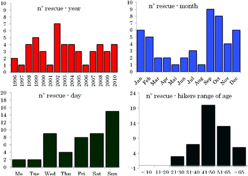
Accidents occur in autumn and winter and primarily involve rescues of missing people either due to unfavourable meteorological and environmental conditions or as a result of people lacking knowledge of the area; secondarily, rescues involve people wounded in accidents along trails or while doing sports such as climbing.
The geohazards along the Mt. Penna and Mt. Aiona area trails depend on the climatic conditions and geomorphological processes ().
Figure 7. Mt. Penna and Mt. Aiona area images. Top left: snowy canyons along the northern side of Mt. Aiona; top right: narrow and exposed tracts of trail equipped with steel chains, on the northern side of the Mt. Penna; low left: typical low-altitude clouds over the Mt. Aiona plateau; low right: typical snowy landscape in Aveto Natural Park.
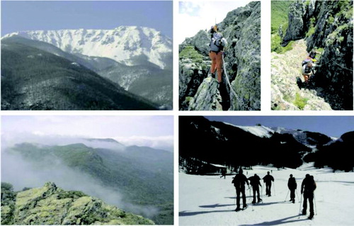
The first include heavy rainfall, storms, snowfall to snowy storms with sudden changes in weather conditions along the watershed; frequent low-altitude cloud and fog on the plateau as well as strong wind along the ridges, with wind-chill effect; snow-covered and iced ground, especially along the slopes oriented to the north and along the Mt. Penna, Mt. Aiona and Mt. Cantomoro canyons. Due to its geographical features, the Mt. Aiona plateau shows peculiar climatic hazards, mainly owing to fog, heavy snowfall and strong winds that have also recently caused the loss of human lives (CitationFaccini, Piccazzo, & Roccati, 2009).
Natural hazards related to geomorphological processes involve gravity, running water, periglacial, snow and ice. The first comprises rock falls along the northern slopes of Mt. Aiona, Mt. Penna and Mt. Cantomoro with resulting fall of debris on either the excursion trails or on alpine and climbing routes of the mountains. Steep valleys can collect loose material which can then produce debris flows when triggered by heavy rainfall; nivation phenomena include several avalanche canyons along the northern slopes of Mt. Aiona and Mt. Cantomoro and localized detachments due to snow accumulations when heavy snowfall occurs caused by wind action.
3. Geomorphologic risk management guidelines
The Mt. Penna and Mt. Aiona area in Aveto Park features geomorphological and climatic conditions typical of an alpine environment; the hazards include gravity-induced processes, triggered by the orography, and by geological and tectonic features, by running water (e.g., debris flow, CitationTheler et al., 2008), and by periglacial processes (nivation phenomena).
Increasing interest in the natural environment and the practice of new sports has attracted a growing number of visitors to this area; more and more often visitors interact throughout the year with the environmental processes and particular climatic conditions of the area (CitationEvans & Clague, 1994).
As a result, there is a potential geomorphological risk related to tourism and associated with the vulnerability of both excursion trails (path characteristics) and the human element (hiking experience and training, technical and physical skills, equipment, knowledge of the area and its natural phenomena); moreover these factors may be worsened by the climatic conditions typical of this area.
A correlation of weather conditions with rescue operations allows for a close relationship to be understood between unfavourable climate conditions and the frequency of events for which relief actions must be provided by rescue teams.
In order to mitigate risks, it is essential to deal with tourist vulnerability factors by improving the trail network and promoting an environmental education campaign. Useful actions that can improve path security include routine maintenance of the trails, the placement of lateral protections and a system of trail signs that can be seen even under particularly unfavourable weather conditions. A deeper awareness on the part of visitors, hikers and sportspersons of the geohazards related to tourist activities, gained through knowledge of the area and its geological, environmental, and climatic conditions. This is essential in order to increase understanding of the natural dynamics and hazards as well as to improve our skill in assessing the resulting risks.
For this purpose, it would be useful to compile a thematic map of the area's routes in relation to the natural environment and its processes; this should indicate primary geohazards, path characteristics, vulnerability situations and weather conditions that can worsen and/or trigger existing hazards and vulnerabilities.
Software
Corel Draw 13 was used for compiling the geo-environmental maps. Microsoft Excel 2002 was used for the climate diagram and weather histograms.
Supplemental Material - Map
Download PDF (7.8 MB)Acknowledgement
We thank Prof. D. Castaldini, Prof. E. Reynard and Dr. M. Wood for their constructive suggestions and comments.
References
- AA.VV. (1988). Carta geomorfologica del crinale appenninico (Settori piacentino, parmense e reggiano p.p.). Scala 1:100.000, Grafis Bologna.
- Beccaluva , L. , Gallo , F. , Piccardo , G. B. , Vernia , L. and Zanzucchi , G. Reworked ophiolites in Upper Cretaceous Flysch and the Mt. Aiona ultramafics, Ligurian-Emilian Apennines . VIth Ophiolite Field Conference, Field Excursion Guidebook (excursion G) . 99–113, GLOM Ed., Firenze
- Beccaluva , L. , Piccardo , G. B. and Serbi , G. 1980b/1979 . “ Petrology of the Northern Apennine ophiolites and comparison with other Tethyan ophiolites ” . In Ophiolites’, Proceedings of International Ophiolites Symposium, Cyprus , Edited by: Panajiotou , A. 314 – 331 . Cyprus : Nicosia .
- Bellinzona , G. , Boni , A. , Braga , G. , Casnedi , R. and Marchetti , G. 1968 . Carta geologica della ‘finestra’ di Bobbio . Atti dell'Istituto Geologia Università di Pavia, XIX(tav. I) ,
- Boni , A. , Braga , G. , Conti , S. , Gelati , R. , Marchetti , G. and Passeri , L. 1969 . Note illustrative ai Fogli 83 (Rapallo) e 94 (Chiavari) della Carta geologica d'Italia 1:100000. 2° Ed . Servizio Geologico Italiano , 89 ( 51 ) : 48 – 73 .
- Bottino , E. , Campomenosi , A. and Cresta , P. 2006 . Parco naturale regionale Aveto – itinerari, natura, cultura e attività, prodotti tipici , Genova : Erredi Grafiche Editoriali .
- Braggio Morucchio, G., & Guido, M. A. (1975). Analisi palinologica dei depositi lacustri post-glaciali del Lago delle Agoraie di Mezzo (Appennino Ligure). Archivio Botanico e Biogeografico Italiano.
- Branch , N. 2004 . “ Late Wurm Lateglacial and Holocene environmental history of the Ligurian Apennines, Italy ” . In Ligurian landscapes: Studies in archaeology, geography and history in memory of Edoardo Grendi, vol 10 , Edited by: Balzaretti , R. , Pearce , M. and Watkins , C. 7 – 69 . London : Accordia Research Institute .
- Brandolini , P. , Faccini , F. and Piccazzo , M. 2006 . Geomorphological hazard and tourist vulnerability along Portofino Park trails (Italy) . Natural Hazards and Earth System Sciences , 6 : 563 – 571 .
- Brandolini , P. , Faccini , F. , Robbiano , A. and Terranova , R. 2008 . Relationship between flood hazards and geomorphology applied to land planning in the upper Aveto Valley (Liguria, Italy) . Geografia Fisica e Dinamica Quaternaria , 31 : 73 – 82 .
- Casnedi , R. 1982 . Sedimentazione e tettonica delle Unità Liguridi nell'Appennino nord-occidentale (Valli Lavagna, Sturla, Trebbia e Aveto) . Atti Istituto di Geologia dell'Università di Pavia , 30 : 42 – 66 .
- Casnedi, R., Galbiati, B., Gallo, F., Vernia, L., and Zanzucchi, G. (1983). Carta geologica delle Ofioliti del Gruppo di Monte Penna e di Monte Aiona (Appennino Ligure-Parmense). S.E.L.C.A. Firenze.
- Casnedi , R. , Galbiati , B. , Vernia , L. and Zanzucchi , G. 1993 . Note descrittive della carta geologica delle ofioliti del Gruppo di M. Penna e di M.Aiona (Appennino Ligure-Emiliano) . Atti Ticinensi di Scienze della Terra , 36 : 231 – 268 .
- Castaldini , D. , Valdati , J. , Ilies , D. C. , Chirian , C. and with contributions by Bertogna I . 2005 . Geo-tourist map of the natural reserve of Salse di Nirano (Modena Apennines, Northern Italy) . Italian Journal of Quaternary Sciences , 18 ( 1 ) : 245 – 255 .
- Castaldini , D. , Valdati , J. and Ilies , D. C. 2009 . Geomorphological and Geotourist maps of the Upper Tagliole Valley (Modena Apennines, Northern Italy) . Memorie Descrittive della Carta Geologica d'Italia , 87 : 29 – 38 .
- Conti , M. , Marcucci , M. and Zanzucchi , G. 1988 . Radiolarian dating of the Mt. Alpe at Costa Scandella, Mt. Penna-Mt. Aiona Group (Ligurian Apennines) . Ofioliti , 13 ( 1 ) : 81 – 84 .
- Coratza , P. and Regolini-Bissig , G. 2009 . “ Methods for mapping geomorphosites ” . In Geomorphosites , Edited by: Reynard , E. , Coratza , P. and Regolini-Bissig , G. 89 – 103 . München : Pfeil Verlag .
- Coratza , P. , Ghinoi , A. , Piacentini , D. and Valdati , J. 2008 . Management of Geomorphosites in high tourist vocation area: An example of geo-hiking maps in the Alpe di Fanes (Natural Park of Fanes-Senes-Braies, Italian Dolomites) . GeoJournal of Tourism and Geosites, Year I , 2 ( 2 ) : 106 – 117 .
- Cutter , S. L. 1996 . Vulnerability to environmental hazards . Progress in Human Geography , 20 : 529 – 539 .
- Elter , P. , Marroni , M. , Molli , G. and Pandolfi , L. 1991 . Le caratteristiche stratigrafiche del complesso di M. Penna-Casanova (Alta Val Trebbia, Appennino settentrionale) . Atti Ticinensi di Scienze della Terra , 34 : 97 – 106 .
- Evans , S. G. and Clague , J. J. 1994 . Recent climatic change and catastrophic geomorphic processes in mountain environments . Geomorphology , 10 : 107 – 128 .
- Faccini , F. , Piccazzo , M. and Roccati , A. 2009 . “ Pericolosità geomorfologica, clima ed escursionismo: il caso del Monte Aiona (Parco Naturale dell'Aveto, Liguria) ” . In Il patrimonio geomorfologico come risorsa per un turismo sostenibile (a cura di P. Coratza, M. Panizza) , 67 – 84 . SAO Società Archeologica s.r.l .
- Fanucci , F. and Nosengo , S. 1977 . Rapporti tra neotettonica e fenomeni morfogenetici del versante marittimo dell'Appennino Ligure e del margine continentale . Bollettino della Società Geologica Italiana , 96 : 41 – 51 .
- Fanucci , F. , Pintus , S. , Tedeschi , D. and Vignolo , A. 1980 . Dati preliminari sulla neotettonica dei Fogli 83–94 Rapallo - Chiavari . Estratto da: Contributi preliminari alla realizzazione della Carta Neotettonica d'Italia , 356 : 1308 – 1311 .
- Goodenough , K. , Pickett , E. , Krabbendam , M. and Bradwell , T. 2004 . Exploring the landscape of Assynt: A walker's guide and map showing the rocks and landscapes of Assynt and Inverpolly , Nottingham : British Geological Survey .
- Losacco , U. 1940 . Appunti sulla morfologia glaciale dell'Appennino Settentrionale . Bollettino della Società Geografica Italiana , 5 : 86 – 107 .
- Losacco , U. 1949 . La glaciazione quaternaria nell'Appennino Settentrionale . Rivista Geografica Italiana , 56 : 196 – 272 .
- Losacco , U. 1982 . Gli antichi ghiacciai dell'Appennino Settentrionale. Studio morfologico e paleogeografico . Atti Soc. Nat. Mat. Modena , 113 : 1 – 224 .
- Marini , M. and Terranova , R. 1975 . I complessi ofiolitiferi dei monti Aiona e Penna e loro rapporti con le serie sedimentarie (Appennino Ligure - Emiliano) . Bollettino della Società Geologica Italiana , 99 : 183 – 203 .
- Marini , M. and Terranova , R. 1979 . Prime osservazioni sui complessi ofiolitiferi compresi fra le valli Trebbia e Aveto (Appennino Ligure-Emiliano) . Ofioliti , 4 ( 3 ) : 351 – 372 .
- Marini , M. and Terranova , R. 1980a . Le serie ofiolitiche nel gruppo dei monti Aiona e Penna nell'Appennino Ligure - Emiliano (Nota preliminare) . Bollettino della Società Geologica Italiana , 94 : 1895 – 1904 .
- Marini , M. and Terranova , R. 1980b . I complessi ofiolitiferi di M. Aiona e Penna e loro rapporti con le serie sedimentarie (Appennino Ligure-Emiliano) . Bollettino della Società Geologica Italiana , 99 : 183 – 203 .
- Marroni , M. and Perilli , N. 1990 . The age of the Mt. Penna-Casanova Complex (External Ligurid Unit., Northern Apennines): New data form the calcareous nannoplacton . Ofioliti , 15 ( 2 ) : 341 – 342 .
- Martin, S. & Reynard, E. (2009). How can a complex geotourist map be made more effective? Popularisation of the Tsanfleuron heritage (Valais, Switzerland). In Proceedings of the 6th European Congress on Regional Geoscientific Cartography and Information Systems, Munich, 9–12 June 2009, Vol. 2, (pp. 261–264). Earth and Man: Bayerisches Landesamt für Umwelt.
- Montanari , C. 1987 . Interesse fitogeografico e paleobotanico degli ambienti palustri della Val d'Aveto . Quaderni dell'Istituto di Geologia della Università di Genova , 5 : 247 – 262 .
- Montanari , C. and Guido , M. A. 1983 . Stato delle conoscenze sulle zone umide dell'Appennino Ligure . Giornale Botanico Italiano , 117 ( Suppl. 1 ) : 129 – 130 .
- Montanari , C. , Guido , M. A. and Braggio Morucchio , G. 1982 . Vicende paleoclimatiche del post-glaciale nell'Appennino Ligure ricostruite attraverso l'esame dei diagrammi pollinici. I Convegno Meteorologia Appenninica, Reggio Emilia 7–10 aprile . Atti del Convegno , : 653 – 660 .
- Parco Naturale Regionale Dell'Aveto . 2005 . L'anello del Cantomoro sentiero ofiolitico…una passeggiata in fondo all'oceano: Guida all'escursione (a cura di Cabella R., De Stefanis A. e P., Girani A., Piazza M., Piccardo G.B.) , Genova : Erga Edizioni .
- Perotti , C. R. , Savazzi , G. and Vercesi , P. L. 1988 . Evoluzione morfotettonica recente della zona compresa tra la testata del T. Nure e la Val d'Aveto. Suppl . Geografia Fisica e Dinamica Quaternaria , 1 : 121 – 140 .
- Piccardo , G. B. 1983 . Genesi delle ofioliti dell'Appennino settentrionale . Memorie della Società Geologica Italiana , 25 : 75 – 89 .
- Piccardo , G. B. , Rampone , E. and Vannucci , R. 1992 . Ligurian peridotites and ophiolites: From rift to ocean formation in the Jurassic Ligure-Piemontese basin . Acta vulcanologica, Marinelli volume 2 , : 313 – 325 .
- Rampone , E. 1987 . Petrology of basaltic dykes from the Mt. Aiona ultramafic (External Ligurids, Northern Apennines, Italy) . Ofioliti , 12 ( 3 ) : 507 – 510 .
- Rampone , E. , Hofmann , A. W. , Piccardo , G. B. , Vannucci , R. , Bottazzi , P. and Ottolini , L. 1995 . Petrology, mineral and isotope geochemistry of the External Ligurids peridotites (Northern Apennine, Italy) . Journal of Petrology , 36 : 81 – 105 .
- Rampone , E. and Piccardo , G. B. 2000 . The ophiolite-oceanic lithospere analogue: New insights from the Northern Apennines (Italy) . Geological Society of America, Special Paper 349 , : 21 – 34 .
- Regione Liguria. (1994). Itinerari escursionistici parco regionale Aveto. Le guide del pettirosso, n. 7 (a cura di Girani A., Meriana G.). Microart's, REcco (GE), ediz. Giugno.
- Regione Liguria. (2005a). Carta Geologica Regionale (CARG) sc. 1:25000– tav. 215.3 – ‘Borzonasca’. Selca, Firenze.
- Regione Liguria. (2005b). Carta Geologica Regionale (CARG) sc. 1:25000 – tav. 215.4 – ‘Santo Stefano d'Aveto’. Selca, Firenze.
- Regolini-Bissig , G. 2010a . “ Mapping geoheritage for interpretive purpose: definition and interdisciplinary approach ” . In Mapping Geoheritage, Lausanne , Edited by: Regolini-Bissig , G. and Reynard , E. 1 – 13 . Institut de Geographie, Géovisions n° 35 .
- Regolini-Bissig G., & Reynard, E. (2010b). Mapping Geoheritage, (Géovisions n° 35), Lausanne, Institut de Géographie.
- Roccati, A. (2011). Geomorphological features and instability phenomena of the slope between Mt. Penna, Mt. Aiona, Mt. degli Abeti and the Gramizza Stream (Upper Aveto Valley, Ligurian Apennines). PhD Thesis, University of Genoa.
- Sacco , F. 1893 . Lo sviluppo glaciale nell'Appennino Settentrionale . Bollettino del Club Alpino Italiano , 69 ( XXVII ) : 263 – 282 .
- Sacco , F. 1937 . Il glacialismo nel gruppo del M. Aiona (Appennino Ligure) . Atti R. Accademia , 73 : 110 – 117 .
- Sapp, M., Miro, M. F., & César, R. (2006). Geological-Tourist Map of Calamuchita's Valley, Cordoba, Argentina, E:1/1.000.0000, Servicio Geológico Minero Argentino, SEGEMAR, Códoba.
- Serrano , E. and Gonzalez Trueba , J. J. 2011 . Environmental education and landscape leisure: Geotourist Map and Geomorphosites in the Picos de Europa National Park . Geojournal of Tourism and Geosites Year Iv , 8 ( 2 ) November : 295 – 308 .
- Servizio Geologico Italiano. (1968). Carta Geologica d'Italia, scala 1:100000, Foglio 83 ‘Rapallo’. 2°Ed., Ist. Poligrafico e Zecca dello Stato, Roma.
- Terranova , R. 1964 . Le brecce dei M. Aiona e Penna nell'Appennino ligure-emiliano (Nota preliminare) . Atti Istituto di Geologia dell'Università di Genova , 2 ( 2 ) : 311 – 328 .
- Terranova , R. 1987 . Gruppo Nazionale Geografia Fisica e Geomorfologia, Sestri Levante 22-25 giugno 1987, Guida alle escursioni . Quaderni dell'Istituto di Geologia della Università di Genova , 5 : 117 – 231 .
- Terranova , R. and Drago , C. 1975 . Le brecce ofiolitiche e poligeniche ed i loro rapporti con le rocce verdi e la serie (sedimentaria nel gruppo del M. Maggiorasca (Appennino Ligure - Emiliano) . Bollettino della Società Geologica Italiana , 94 : 1905 – 1927 .
- Terranova , R. and Zanzucchi , G. 1981 . Relationship between ophiolites and flysch sequence in the Mt. Penna - Mt. Ragola area (Ligurian - Emilian Apennines) . Ofioliti , 6 : 287 – 292 .
- Theler , D. , Reynard , E. and Bardou , E. 2008 . Assessing sediment dynamics from geomorphological maps: Bruchi torrent system, Swiss Alps . Journal of Maps , : 277 – 289 .
- Van Wamel , W. A. 1987 . On the tectonics of the Ligurian Apennines (Northern Italy) . Tectonophysics , 142 : 87 – 98 .
- Van Zupthen , A. C. A. , Van Wamel , W. A. and Bons , A. J. 1985 . The structure of the Val Lavagna Nappe in the region of the Monte Ramaceto and Val Graveglia (Ligurian Apennines, Italy) . Geologie en Mijnbouw , 64 : 373 – 384 .