Abstract
In arid and semiarid regions, vegetative boundaries are often strikingly similar to landform boundaries. However, it is not well documented whether landforms exert an influence on the resistance of desert grassland to shrub encroachment. Dominant grassland communities have been displaced by woody shrubs over the last 150 years in the Jornada Basin, southern New Mexico. Digital vegetation maps from 1858, 1915–1916, 1928–1929, 1938, and 1998, in conjunction with a detailed landform map, were analyzed in a Geographical Information System. The generated time series maps and spatial data compiled from these datasets were used to quantify the extent and rate that grasslands were replaced by shrubs on eight contiguous landforms. From this assessment, we generated a resistance index that revealed desert grasslands were least resistant (most susceptible) to shrub expansion on sandy landforms and bajadas and most resistant to shrub invasion on ephemerally flooded playas. This study demonstrates that landforms both provide the broad-scale background for detailed mechanistic studies and affect the sensitivity of grasslands to shrub encroachment.
1. Introduction
As a result of desertification, semiarid grasslands in many parts of the world have been displaced by woody plants (CitationEldridge et al., 2011). In the Jornada Basin of southern New Mexico USA, the displacement of perennial grasslands is well documented beginning in 1858 (CitationBuffington & Herbel, 1965). However, remnant grass patches still exist in several locations in the Jornada Basin that have resisted this encroachment (CitationGibbens, McNeely, Havstad, Beck, & Nolan, 2005). The underlying mechanisms and drivers responsible for these landscape patterns are complex and the focus of much ecological investigation, including nonlinear thresholds (CitationPeters et al., 2004, Citation2006, Citation2008), the effects of state changes (CitationBestelmeyer, Goolsby, & Archer, 2011), runoff-runon (CitationRango, Tartowski, Laliberte, Wainwright, & Parsons, 2006; CitationWainwright, Parsons, & Abrahams, 2000; CitationWainwright, 2006), soil water holding capacity (CitationDuniway, Herrick, & Monger, 2010), connectivity (CitationOkin et al., 2009), fire frequency (CitationHavstad et al., 2006), and resource islands (CitationSchlesinger et al. 1990; CitationSchlesinger, Raikes, Hartley, & Cross, 1996), in addition to the traditional explanations of overgrazing and drought (CitationBuffington & Herbel, 1965; CitationHerbel, Ares, & Wright, 1972; CitationNeilson, 1986). As a supplement to mechanistic studies, it is important to identify where vegetative change has been most and least rapid.
The linkage between plant communities and landforms in arid and semi-arid ecosystems is well established (CitationBaxbaum & Vanderbilt, 2007; CitationMcAuliffe, 1994; CitationParker, 1995). These broad-scale patterns consist of differences in the physical and chemical composition of parent material, soil, and topographic relief (CitationMonger & Bestelmeyer, 2006). These properties influence the ability of a landscape to buffer biotic and abiotic changes through time. Low-lying areas, for example, that concentrate water and nutrients can be insensitive to climatic change and shifts in vegetation communities through time (CitationParsons, Wainwright, Schlesinger, & Abrahams, 2003; CitationRango et al. 2006). Sandy, flat upland landforms or sloped gravelly alluvial fans with low water holding capacity can be less buffered than run-in areas and more sensitive to climatic change that results in shifts in vegetation communities (CitationBrowning, Archer, Asner, McClaran, & Wessman, 2008; CitationGardner, 1951; CitationPeters et al., 2010).
Rate of loss of grasslands and amount of resistance that a given landform can provide that impedes shrub encroachment has not been well quantified. The purpose of this study was to use vegetation data layers, based on historic land survey notes, and landforms data layer for Jornada Basin Long-Term Ecological Research study area in southern New Mexico to generate a grassland resistance map to address the following question: On which landforms have desert grasslands been most resistant?
2. Setting
The Jornada Basin is located in the Basin and Range Physiographic Province of south-central New Mexico on the northern cusp of the Chihuahuan Desert bioclimatic zone (CitationPeterson, 1981; CitationSchmidt, 1979) (). Topography of the basin is the result of Tertiary tectonics along with Quaternary climatic cycles imprinted onto the landscape as stepped sequences of geomorphic surfaces along major streams and buried paleosols in depositional environments along mountain fronts (CitationGile, Hawley, & Grossman, 1981). These cycles of landscape stability (i.e. increased soil development) and instability (i.e. increased erosion/sedimentation) have shaped the basin into a three-dimensional landscape composed of individual landforms with unique physical and chemical properties (, ). The study area includes the United States Department of Agriculture (USDA) administered Jornada Experimental Range (JER, 58,600 hectares) and adjacent New Mexico State University property, the Chihuahuan Desert Rangeland Research Center (CDRRC, 25,671 hectares). Both research facilities are protected areas that were created during the early 1900s to better understand the effects of grazing patterns on shrub encroachment and grassland persistence. These research facilities have implemented similar land management practices over the last 75 years to mitigate the harmful effects of shrub encroachment.
Table 1. Summary of landform descriptions for the Jornada Basin.
Figure 1. Location of the Jornada Basin is positioned on the northern portion of the Chihuahuan Desert in southern New Mexico with block diagram illustrating landforms.
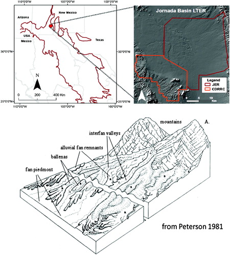
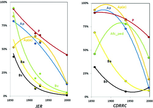
Figure 2. Percent grass cover through time showing the differences among landforms.
The Jornada Basin experiences hot, arid conditions (mean daily temperatures vary between 15°C and 37.8 °C) with highly variable annual precipitation (80-year avg = 242 mm year−1). Precipitation is received in a bimodal pattern with approximately 70% occurring in July through September, and the remainder falling as winter precipitation (CitationSynder, Mitchell, & Herrick, 2006; CitationWainwright, 2006).
3. Methods
The landform map depicts eight units for the Jornada Basin. The map adjoins the northern Desert Project soil and geomorphic surface maps (CitationGile et al., 1981) and was made by groundtruthing landforms delineated on true-color, stereo-pair aerial photographs (scale 1:32,000), Landsat images, and a 10-m digital elevation model (CitationMonger & Bestelmeyer, 2006). Landform units were classified using Definitions Cognition in CitationPeterson (1981) and CitationGile et al. (1981) ().
Vegetation maps reconstructed from historic land survey notes (CitationBuffington & Herbel, 1965) and recent field mapping were compiled and analyzed by CitationGibbens et al. (2005) for the Jornada Basin. The original 1858 map was generated from historic survey notes that ranked the quality of the grassland into categories such as good grass, fair grass, and poor grass. These categories were reclassified by CitationBeltran-Przekurat, Pielke, Peters, and Snyder (2008) into dominant vegetation types used in the current analysis. The 1858 and 1998 vegetation data layers cover the entire Jornada Basin while 1915–1916, 1928–1929 cover the JER, but not the CDRRC. A 1938 vegetation map that only covers the CDRRC was used to supplement the analysis. These data layers contain upland and lowland grasslands. The minimal mapping unit was four hectares (10 acres). Because the JER and CDRRC are managed by different agencies (USDA, NMSU, respectively), we analyzed these land units separately.
Upland and lowland grasslands were consolidated into one general grassland class. The grassland polygons were then intersected with the landform data layer. The attribute tables for the intersected data layer were re-populated and a series of queries were conducted in GIS for each mapped year. The distribution of grasslands by landform units was calculated for each temporal dataset. A resistance index (RI) was developed to quantify the sensitivity of a grassland on a landform to change since 1858 (Equation 1).
Where GLs is the resistance index based on the grassland percentage on a specific landform (Li) in 1998 compared to its percentage on that landform in 1858. Output from this calculation ranges from 0 to 1 with a value of 0 indicating the least resistant while a value of 1 indicating most resistant grassland on a specific landform to change.
4. Results
The percentages of grasslands for the eight landforms through time are shown in , and , while resistance index values are shown in . Grassland decline curves are shown in and provide a visual representation illustrating the trajectory of change in grass cover through time. Grasslands decreased in percentage area on all landforms in both land units from 1858 to 1998 (). Desert grasslands were less resistant and exhibited the greatest amount change in spatial coverage on the bajada sand sheet (Bs), bajada (Ba), banded vegetation (Bv), and sandy alluvial plain (Ap) (). The bajada sand sheet, gravelly bajada, and banded vegetation units exhibited the most change by losing 98%, 96% and 96% of historic grassland cover, respectively. In addition, the bajada (Ba), bajada sandsheet (Bs), and band vegetation (Bv) have similar decline curves through time with a sharp concave drop in grassland cover that predated 1915. This decline in grass cover resulted in a very low RI (0.02, 0.03 0.04, respectively). Lastly, sandy alluvial plain lost 85% of its historic grassland cover and also had a low RI (0.16). The decline curve for this landform unit illustrates a linear decrease in grass cover through time for both the JER and CDRRC.
Table 2. Vegetation coverage (as a % of the land area, either JER or CDRRC) by year, % change (based on number of hectares in 1858 and 1998), and Resistance Index (RI) for landform units on the Jornada Basin.
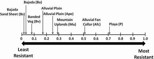
Figure 3. Resistant Index of landform units for the Jornada Basin.
However, not all landforms units experienced major losses of historic grassland cover. The mountain uplands (Mu) and alluvial plain eroded (ap(e)) exhibited minor changes in grassland cover when compared with the bajada sites (). The grassland curve for both of these landform exhibited different trajectories. The eroded alluvial plain exhibited minimal grassland cover loss between 1915 and 1928 followed with the majority of grass cover loss within the last 70 years. However, mountain uplands had a shallow concave trajectory of grass cover loss between 1915 and 1928 that rebounded in the 1998. Mountain uplands (Mu) lost 68% of historic grass cover with an RI value of 0.31 while eroded alluvial plain eroded lost 73% of grass cover with an RI value of 0.27. Playas (p) and the alluvial fan collar (afc_ped) exhibited the least amount of change with a decline of 29% and 47% of historic grass cover, respectively, followed by RI values of 0.71 and 0.51, respectively. The grass cover curve for the playas was linear for the JER and shallow convex for CDRRC. However, the alluvial fan collar curve (afc_ped) was parabolic with an increase in grass cover from 1915 to 1928 followed by a decline in 1998 (, and ).
5. Discussion
Using a grassland resistance map illustrates that the sandy alluvial plain and bajada landform units are the least resistant to change while the low-lying playas were the most resistant landform to grassland loss and shrub encroachment since 1858. Differences in grassland resistance among landforms illustrate the differential response that landform patterns can have on grass cover and shrub encroachment. The grassland patterns observed today are most likely driven by the inherent properties of each landform unit, including the physical and chemical composition of parent material, soil, and topographic relief (CitationMonger & Bestelmeyer, 2006).
The gravelly bajada, for example, is the least buffered landform with a steeply declining curve and a RI of 0.02. This sensitivity to climate change and shrub encroachment could be driven by the rocky nature of the soil, and its affect on water holding capacity because rock fragments occupy space in soil that could otherwise hold water in fine pores (CitationHallmark & Allen, 1975; CitationPeters, Herrick, Monger, & Huang, 2010). The bajada sandsheet also has a steep slope and a low RI value of 0.03 indicating it is a sensitive landform unit to grassland loss. Deposition of sand blown from the wind eroded alluvial plain on to the bajada could result in the loss of grass cover by burying the vegetation during periods of high erosion/deposition rates (CitationOkin, Murray, & Schlesinger, 2001). Sandy alluvial plain, which is the sediment source area for the bajada sandsheet, had a steady linear decline curve with RI value of 0.16 and little resistances to shrub encroachment. Sandy textured soils characteristic of this landform can have higher shrub seedling establishment rates when compared to finer texture soils (CitationBrowning et al., 2008).
However, the eroded alluvial plain had most grassland loss over a 70-year time period and a slightly higher RI (0.27) when compared to the bajada units and sandy alluvial plain. The eroded alluvial plain is characterized by exhumed or shallow cemented soil horizons that can retain plant available water for long periods of time (CitationDuniway et al., 2010; CitationMonger, 2006). Grasslands on these soil horizons can persist in extreme drought conditions that otherwise result in major shifts in vegetation communities for most of the Jornada Basin (CitationGibbens et al., 2005; CitationHerbel et al., 1972). Mountain uplands had a slightly higher RI (0.32) when compared to the bajada units, sandy alluvial plain, and eroded alluvial plain. Soils forming in bedrock fissures that contain higher nutrient content than the surrounding bedrock and higher water hold capacity could make mountain uplands more buffered and less sensitive to shifts in vegetation communities over time (CitationDasgupta et al., 2006; CitationNeff et al., 2006; CitationVaughan and McDaniel, 2008). Alluvial fan collar and playas are the most buffered landforms in the basin with RI of 0.71 and 0.51, respectively. The grass cover decline curve for the playas were linear to shallow convex while the alluvial fan collar had a parabolic curve. The character of the curve and high resistance values could be influenced by the run-in position on both landforms, where they receive run-off and nutrient inputs from the adjacent mountain slopes or upland areas of the basin (CitationRango et al., 2006; CitationWondzell et al., 1996).
6. Conclusion
A grassland resistance map created in this study was able to quantify and illustrate the landforms that have been the most resistant and vulnerable to shrub encroachment in the Jornada Basin, southern New Mexico since 1858. Desert grasslands were less resistant and exhibited a dramatic decline in spatial coverage on the sandy alluvial plain and bajada landform units. In contrast, the mountain uplands, alluvial fan collar and low-lying playas were most resistant to change; thereby, providing a stronghold for desert grasslands to resist the detrimental effects of shrub encroachment. Rangeland management strategies can benefit from an understanding of the differential responses that individual landform units have on shrub encroachment and grass cover change over time. Documenting which landforms have persistent grassland cover can also benefit studies designed to understand the underlying mechanisms responsible for the dramatic ecosystem conversion that is happening in vast areas of the arid and semiarid world.
Software
The historic vegetation and landform map layers were managed, analyzed and the final map constructed using ESRI ArcGIS 9.3.
tjom_a_727593_sup_28634591.pdf
Download PDF (61.3 MB)Acknowledgements
We thank Peg Gronenymer, and Barbara Nolen for their assistance in data retrieval, and comments on map design and layout. We also appreciate the anonymous reviewers for their comments on this manuscript and the map. Funding for this study was provided by the Jornada Basin LTER program (National Science Foundation DEB-0080412) and the New Mexico State University-Agricultural Experiment Station.
Related Research Data
References
- Baxbaum , C. A. Z. and Vanderbilt , K. 2007 . Soil heterogeneity and the distribution of desert and steppe plant species across a desert-grassland ecotone . Journal of Arid Environments , 69 : 617 – 632 . (doi:10.1016/j.jaridenv.2006.11.017)
- Bestelmeyer , B. T. , Goolsby , D. P. and Archer , S. R. 2011 . Spatial perspective in state and transition models: A missing link to land management? . Journal of Applied Ecology , 48 ( 3 ) : 746 – 757 . (doi:10.1111/j.1365-2664.2011.01982.x)
- Beltran-Przekurat , A. , Pielke , R. A. , Peters , D. P. C. and Snyder , K. 2008 . Modeling the effects of historical vegetation change on near-surface atmosphere in the northern Chihuahuan Desert . Journal of Arid Environments , 72 : 1897 – 1910 . (doi:10.1016/j.jaridenv.2008.05.012)
- Browning , D. M. , Archer , S. R. , Asner , G. P. , McClaran , M. P. and Wessman , C. A. 2008 . Woody plants in Grasslands: Post-encroachment stand dynamics . Ecological Application , 18 : 928 – 944 . (doi:10.1890/07-1559.1)
- Buffington , L. C. and Herbel , C. H. 1965 . Vegetation changes on a semi-desert grassland range from 1858 to 1963 . Ecological Monographs , 35 : 139 – 164 . (doi:10.2307/1948415)
- Dasgupta, S., Mohanty, B.P., & Köhne, J.M. (2006). Impacts of juniper vegetation and karst geology on subsurface flow processes in the Edwards Plateau. Texas.Vadose Zone Journal, 5, 1076–1085.
- Duniway , M. C. , Herrick , J. E. and Monger , H. C. 2010 . Spatial and temporal variability of plant-available water in calcium carbonate-cemented soils and consequences for arid ecosystem resilience . Oceologia , 163 : 215 – 226 . (doi:10.1007/s00442-009-1530-7)
- Eldridge , D. J. , Bowker , M. A. , Maestre , F. T. , Roger , E. , Reynolds , J. F. and Whitford , W. G. 2011 . Impacts of shrubs encroachment on ecosystem structure and functioning: Towards a global synthesis . Ecology Letters , 14 : 709 – 722 . (doi:10.1111/j.1461-0248.2011.01630.x)
- Gardner , J. L. 1951 . Vegetation of the creosotebush area of the Rio Grande Valley in New Mexico . Ecological Monographs , 21 ( 4 ) : 379 – 403 . (doi:10.2307/1948655)
- Gibbens , R. P. , McNeely , R. P. , Havstad , K. M. , Beck , R. F. and Nolan , B. 2005 . Vegetation changes in the Jornada Basin form 1858 to 1998 . Journal of Arid Environments , 61 : 651 – 668 . (doi:10.1016/j.jaridenv.2004.10.001)
- Gile , L. H. , Hawley , J. W. and Grossman , R. B. 1981 . Soils and geomorphology in the Basin and Range area of southern New Mexico—Guidebook to the Desert Project Memoir 39 , Socorro, New Mexico : New Mexico Bureau of Mines and Mineral Resources .
- Hallmark , C. T. and Allen , B. L. 1975 . The distribution of creosotebush in west Texas and eastern New Mexico as affected by selected soil properties . Soil Science Society of America Proceedings , 39 : 120 – 124 . (doi:10.2136/sssaj1975.03615995003900010032x)
- Herbel , C. H. , Ares , F. N. and Wright , R. A. 1972 . Drought effects on a semi-desert grassland range . Ecology , 53 : 1084 – 1093 . (doi:10.2307/1935420)
- McAuliffe , J. R. 1994 . Landscape evolution, soil formation, and ecological patterns and processes in Sonoran Desert bajadas . Ecological Monographs , 64 : 111 – 148 . (doi:10.2307/2937038)
- Monger , H. C. 2006 . “ Soil development in Jornada Bas ” . In Structure and function of a Chihuahuan Desert ecosystem: The Jornada Basin Long-Term Ecological Research Site , Edited by: Havstad , K. M. , Huennke , L. F. and Schlesinger , W. H. 81 – 106 . New York , NY : Oxford University Press .
- Monger , H. C. and Bestelmeyer , B. T. 2006 . The soil-geomorphic template and biotic change in arid and semi-arid ecosystems . Journal of Arid Environments , 65 : 207 – 218 . (doi:10.1016/j.jaridenv.2005.08.012)
- Neff, J.C., Reynolds, R., Sanford, Jr. R.L., Fernandez, D., & Lamothe. P. (2006). Controls of bedrock geochemistry on soil and plant nutrients in Southeastern Utah. Ecosystems, 9(6), 879–893.
- Neilson , R. P. 1986 . High-resolution climatic analysis and southwest biogeography . Science , 232 : 27 – 34 . (doi:10.1126/science.232.4746.27)
- Okin , G. S. , Murray , B. and Schlesinger , W. H. 2001 . Degradation of sandy arid shrubland environments: Observations, process modeling, and management implications . Journal of Arid Environments , 47 : 123 – 144 . (doi:10.1006/jare.2000.0711)
- Okin, G.S., Parsons, A.J., Wainwright, J., Herrick, J.E., Bestelmeyer, B.T., Peters, D.P.C., & Fredrickson, E.L. (2009). Do changes in connectivity explain desertification? BioScience, 59(3): 237–244.
- Parker , K. 1995 . Effects of complex geomorphic history on soil and vegetation patterns arid alluvial fans . Journal of Arid Environments , 30 : 19 – 39 . (doi:10.1016/S0140-1963(95)80036-0)
- Parsons , A. J. , Wainwright , J. , Schlesinger , W. H. and Abrahams , A. D. 2003 . The role of overland flow in sediment and nitrogen budgets of mesquite dunefields, southern New Mexico . Journal of Arid Environments , 53 : 61 – 71 . (doi:10.1006/jare.2002.1021)
- Peters , D. P.C. , Pielke , R. A. , Bestelmeyer , B. T. , Allen , C. D. , Munson-McGee , S. and Havstad , K. M. 2004 . Cross-scale interactions, nonlinearities, and forecasting catastrophic events . Proceedings of the National Academy of Science , 101 : 15130 – 15135 . (doi:10.1073/pnas.0403822101)
- Peters , D. P.C. , Bestelmeyer , B. T. , Herrick , J. E. , Monger , H. C. , Fredrickson , E. and Havstad , K. M. 2006 . Disentangling complex landscapes: New insights into arid and semiarid system dynamics . Bioscience , 56 : 491 – 501 . (doi:10.1641/0006-3568(2006)56[491:DCLNII]2.0.CO;2)
- Peters, D.P.C., Groffman, P.M., Nadelhoffer, K.J., Grimm, N.B., Collins, S.L., Michener, W.K., & Huston, M.A. (2008). Living in an increasingly connected world: a framework for continental-scale environmental science. Frontiers in Ecology and the Environment, 6, 229–237.
- Peters , D. P.C. , Herrick , J. E. , Monger , H. C. and Huang , H. 2010 . Soil-Vegetation-climate interactions in arid landscapes: Effects of the North American monsoon on grass recruitment . Journal of Arid Environments , 74 : 618 – 623 . (doi:10.1016/j.jaridenv.2009.09.015)
- Peterson, F.F. (1981). Landforms of the basin and range province defined for soil survey. (p. 52). Reno, NV: Nevada Agricultural Experiment Station Technical Bulletin No. 28.
- Rango , A. , Tartowski , S. L. , Laliberte , A. , Wainwright , J. and Parsons , A. 2006 . Islands of hydrologically enhanced biotic productivity in natural and managed arid ecosystems . Journal of Arid Environments , 65 : 235 – 252 . (doi:10.1016/j.jaridenv.2005.09.002)
- Schlesinger , W. H. , Reynolds , J. F. , Cunningham , G. L. , Huenneke , L. F. , Jarrell , W. M. , Virginia , R. A. and Whitford , W. G. 1990 . Biological feedbacks in global desertification . Science , 247 : 1043 – 1048 . (doi:10.1126/science.247.4946.1043)
- Schlesinger , W. H. , Raikes , J. A. , Hartley , A. E. and Cross , A. F. 1996 . On the spatial pattern of soil nutrients in desert ecosystems . Ecology , 77 : 364 – 374 . (doi:10.2307/2265615)
- Schmidt, R.H. (1979). A climatic delineation of the ‘real’ Chihuahuan Desert region. Journal of Arid Environment, 2, 243–250.
- Synder , K. A. , Mitchell , K. A. and Herrick , J. E. 2006 . “ Patterns and controls of soil water int the Jornada Bas ” . In Structure and function of a Chihuahuan Desert Ecosystem: The Jornada Basin Long-Term Ecological Research Site , Edited by: Havstad , K. M. , Huenneke , L. F. and Schlesinger , W. H. 107 – 132 . New York , NY : Oxford University Press .
- Vaughan, K.L., & McDaniel. P.A. (2009). Organic soils on basaltic lava flows in a cool, dry environment. Soil Sci. Soc. Am. Journal, 73, 1510–1518.
- Wainwright , J. , Parsons , A. J. and Abrahams , A. D. 2000 . Plot-scale studies of vegetation, overland flow and erosion interactions: Case studies from Arizona and New Mexico . Hydrological Processes , 14 : 2921 – 2943 . (doi:10.1002/1099-1085(200011/12)14:16/17<2921::AID-HYP127>3.0.CO;2-7)
- Wainwright , J. A. 2006 . “ Climate and climatological variations in the Jornada Bas ” . In Structure and function of a Chihuahuan Desert Ecosystem: The Jornada Basin Long-Term Ecological Research Site , Edited by: Havstad , K. M. , Huenneke , L. F. and Schlesinger , W. H. 44 – 80 . New York , NY : Oxford University Press .
- Wondzell, S.M., Cunningham, G.L., & Bachelet. D. (1996). Relationships between landforms, geomorphic processes, and vegetative communities on a watershed in the Northern Chihuahuan Desert. Landscape Ecology, 11, 351–362.