Abstract
The Pálava Protected Landscape Area (PLA) is one of the protected areas in the Czech Republic that is characterized by both natural and cultural heritage. The Atlas of Pálava PLA presented in this article has been created as a general publication summarizing a majority of available data and information of the area in an original and uniform style.
A wide range of information from geology, geomorphology, climate and hydrology, nature and its conservation, tourism and economy is presented over five thematic groups, 15 chapters and 30 maps (using mainly 1:35,000 and 1:50,000 scales), arranged alternating text and map pages to describe a theme. Various methods including (i) point, line and area symbols, (ii) choropleths, (iii) flowline maps, (iv) diagram maps and their combinations were used for the visualization of the thematic data. The uniform style of the maps was ensured by including shaded relief for the visualization of terrain, water bodies and urbanized area as a topographic base.
The process of its creation included obtaining and harmonizing various types of (spatial) data (raster and vector datasets, digitizing of paper maps, correlation of various typology systems, linking of table and spatial data), planning the atlas and map concepts, using software and applying a theoretical basis of cartography, geography and geoinformatics in order to produce a complete guide of the area. The Atlas of Pálava PLA presents well-founded knowledge of the region in an easily available form, as it is available on the internet as a digital version in PDF.
1. Introduction
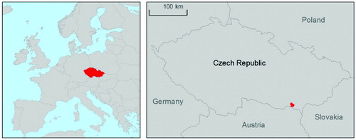
The Pálava Protected Landscape Area (PLA) covers 83 km2 in the very south-eastern part of the Czech Republic (). Because of its natural and landscape value, it has been recognized as a Biosphere Reserve under UNESCO's Man and the Biosphere Programme, contains Ramsar Sites and declared a Special Protection Area (SPA) and a Site of Community Importance (SCI) within the NATURA 2000 network (CitationČtyřoký et al., 2007).
Figure 1. Location of the Pálava Protected Landscape Area within the Czech Republic.
The axis of the region is the limestone Pavlovské vrchy hills, which are surrounded by agricultural land of vineyards, orchards, fishponds and fields. This area is of ecological (e.g. grasslands, thermophilic oak woods, scree woods and floodplains ecosystems), historical (e.g. archaeological findings of the settlements of mammoth hunters from 34 to 25 ka BC and ruins of several medieval castles) and touristic importance (CitationČtyřoký et al., 2007).
In keeping with recently published atlases (CitationLafreniere & Rivet, 2010; CitationOrtega Perez, Mancebo Quintana, & Otero Pastor, 2011; CitationPeterson & Wendel, 2007), the aim of the work presented in this article is to summarize various spatial data, photographs and information about PLA in a representative publication, combining maps and texts in order to fully describe the area and provide a complete guide to the area and its geography for the public, e.g. visitors of the PLA or students. The atlas was created as a Bachelor thesis in the Department of Physical Geography and Geoecology, the University of Ostrava (CitationMiklín, 2008a) in liaison with the PLA Administration. The complete portable document format (PDF) version is freely available on the internet (CitationMiklín, 2008b) and sample prints can be viewed at the headquarters of the PLA Administration in Mikulov.
2. Methods
In order to cover a wide range of themes (e.g. geology, ecology, history, and tourist information), various methods and data had to be used. The preparation of the atlas project is described below.
2.1 Atlas concept
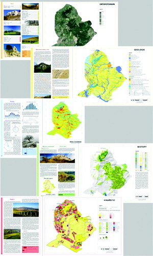
The atlas consists of both texts and maps, alternating one text with one map page to describe each theme using A3 portrait (297 × 420 mm) page size. Because of their size, some themes require more than one map or text page. The themes and maps presented were selected according to (i) data and information availability, (ii) potential for graphical or map presentation and (iii) to cover a wide variety of geographic themes in order to appeal to wide range of end-users including visitors and tourists, students and local residents. For easier orientation, the content is divided into five groups differentiated by color: (i) Introduction (orange), (ii) Geology, geomorphology and soils (yellow), (iii) Hydrology and climate (blue), (iv) Nature and its protection (green) and (v) Human activities (red) (). Colors are used in the numbering of pages and images captions, to mark the page border or to highlight important information in the text.
Figure 2. Atlas layout with the arrangement of text and map pages describing a certain theme, including different colors for various chapters. For detail, see the map supplement.
The atlas contains 15 text chapters and 30 maps, mainly at 1:35,000 and 1:50,000 scales (). The scale used for a particular map depends on the spatial accuracy of the data and available page formats. Maps at 1:35,000 scale were prepared in A2 landscape format (594 × 420 mm) and then folded into A3 portrait.
Table 1. Content of the atlas and the scales at which maps were prepared. Maps accompanying the paper are marked with *.
2.2 Data sources and collection
Maps are based on various types of data both with respect to the file format (raster and vector geodata, tables) and sources (government administration and institutions, private companies, unpublished data and own data, prepared or mapped by the author). Some of the data used have been published in thematic maps (e.g. geology, hydrology, and soil types), geographic information system (GIS) servers (orthophoto, nature conservation, etc.) or books (potential vegetation; CitationNeuhäuslová, 2001). All data were clipped to the PLA border with most needing some preparation such as digitizing (geology, geomorphology, hydrogeology, sights and tourism, potential vegetation, soils), generalization (NATURA 2000 habitats, nature conservation), and harmonization (almost all datasets) to a common standard.
2.3 Maps and cartography
All the maps were created to a uniform style with (i) shaded relief for the visualization of terrain, (ii) water courses and bodies and (iii) towns and village areas as a topographic base. For the visualization of thematic data, (i) point, line and area symbols, (ii) choropleths, (iii) flowline maps, (iv) diagram maps, and their combinations were used (see CitationDykes, MacEachren, & Kraak, 2005 or CitationTyner, 2010 for details about the methods). The Czech cartographic Křovák projection and S-JTSK geographic coordinate system were used for all maps (see CitationKřovák, 1959 for details).
3. Maps presented in this paper
3.1 Geomorphology
The chapter on geomorphology and relief of Pálava PLA describes landform regions of the area, morphometric parameters and general relationships between lithology, landform processes and landforms and their development. The text is supplemented with a geomorphological map (1:50,000), maps of landform regions and types (1:120,000) and maps of hill slope and aspect (1:50,000).
The geomorphological map was created as a digitized version of the map made by CitationBalatka, Czudek, Demek, Ivan, and Sládek (1968) using point, line and area symbols according to Demek and Embleton (1976) and a digital geomorphological symbol set detailed by CitationLétal and Voženílek (2002). In the legend, landforms were divided into groups according to their genesis (e.g. periglacial, fluvial and aeolian landforms).
The map of landform types was digitized after CitationDemek and Macka (1970) who divided the area according to its morphometric and lithological characteristics. Geomorphological regionalization of the Czech Republic, which was used in the map, is based on CitationDemek and Mackovčin (2006).
The morphometric maps (hill slope and aspect) were created using ArcGIS Spatial Analyst over contour layers; water courses and water bodies shapefiles were sourced from ZABAGED (Czech national base center for geographic data, the most detailed vector dataset at 1:10,000 scale; see CitationPlischke & Uhlíř, 1997 for details). Both maps have a specially developed legend clearly visualizing theme.
3.2 Soils
The map of soils uses areal symbols to visualize the distribution of soils within Pálava PLA. The compilation included digitized data from thematic soil maps of the Czech Geological Survey (CitationČGS, 2009) and the Agency for Nature Conservation and Landscape Protection of the Czech Republic (CitationAOPK, 2007). The mapmaking process necessitated the combination of several map series, including the correlation of two different soil classification systems (CitationNěmeček et al., 2001; CitationTomášek & Kovanda, 1986) as each part of the PLA was mapped at a different time, using a different classification system.
3.3 Hydrology
The hydrological map combines several thematic maps and data resources in one map, including groundwater and surface water features. The application of various cartographic methods in the creation of the map made it possible to include (i) groundwater features (e.g. springs and swells) as point symbols, (ii) hydrogeological features (e.g. aquifers and isolators and their variations) as area symbols, (iii) transmissivity in the form of choropleths, (iv) water bodies, water courses and areas at risk of flooding as line and area symbols.
3.4 Nature conservation
Combining the national, European and international approach, the Czech system of nature conservation includes several types of protected areas (for an overview see CitationCENIA, 2008). The PLA is one of two ‘large-scale’ reserve types in the Czech Republic, the other being a National Park (NP). PLAs are declared in areas with a harmonious cultural landscape preserving important natural and historical heritage, whilst NPs are areas with a significant proportion of the natural ecosystem untouched by man where nature conservation is of greater importance than economic exploitation. The area of NPs and PLAs is divided into graded zones of protection, with the 1st zone reserved for the most valuable areas.
There are also four types of ‘small-scale’ reserves including National Nature Reserves (NNR, with representative ecosystems within the Czech Republic), Nature Reserves (NR, with ecosystems significant at a regional/local scale), National Nature Monuments (NNM, protecting specific phenomena such as rocks or caves of national/international significance) and Nature Monuments (NM, analogous to NNM, but of regional/local significance).
Within NATURA 2000, a European system of nature conservation, two types of reserves are declared: (SCI, including typical, well-preserved ecosystems according to CitationCEC, 1992) and (SPA, areas with the occurrence of endangered bird species declared according to CitationCEC, 1979). Both of these are also recognized by the Czech legislation (CitationČNR, 1992).
Based on international treaties (CitationMatthews, 1993), Ramsar Sites are declared in order to conserve wetlands. The whole of the PLA is recognized as a Biosphere Reserve under UNESCO's Man and the Biosphere Programme (CitationČtyřoký et al., 2007). However, these types of nature protection (Ramsar sites and Biosphere reserves) are not included in the law of the Czech Republic (CitationCENIA, 2008).
Related to trees, rather than landscape, is the Institute of Protected Tree (CitationČNR, 1992); such trees, declared by public administration, are under special protection.
All these types of nature protection are found in Pálava PLA including (i) small-scale reserves with four NNRs, one NNM, five NRs and three NMs covering 10% of the PLA; (ii) NATURA 2000 sites with eight SCIs covering 38% of the PLA and the whole PLA divided into two SPAs; (iii) two Ramsar Sites including a trilateral Czech-Slovak-Austrian Ramsar Site – ‘Floodplains of the Morava-Dyje-Danube Confluence’ and (iv) five protected trees, four of which found in the town of Mikulov.
The primary goal of the map of nature conservation was to show zonation and all types of protected areas on the map, including cases of overlapping of individual categories. Green hue areal symbols were used for the zonation (the darkest hue of green for first zone of protection, the lightest hue of green for fourth zone), while hachures combining various colors and angles were used for reserves (green for state reserves, brown for SCI and blue for Ramsar sites; SPA and Biosphere reserve are not included as they are declared at whole area of PLA). The map page is supplemented with a pie chart showing percentages of the zones, SCIs and small-scale reserves in the PLA.
3.5 Problems of PLA
Two of the major problems of the PLA presented in the map are (i) an extreme increase in the number of visitors to several places of interest during Spring and (ii) invasive species. The number of visitors per day in selected places is visualized using diagrams, whereas the number of visitors on selected paths by means of flowlines (data from CitationGoldman, 2004). Invasive species (Dwarf Elder Sambucus ebulus, Ailanthus altissima and Himalayan Balsam Impatiens glandulifera are the most problematic in Pálava PLA) are visualized using point (for spot occurrence) and areal symbols (data sourced from CitationGoldman, 2006).
3.6 Viticulture
With vineyards covering 16% of the PLA (CitationMiklín & Smolková, 2011), wines and viticulture are important phenomena and the most important viticulture area in the Czech Republic, with benefits for tourism (e.g. special bikeways through vineyards and along wine cellars) and the economy. White grape varieties prevail, Riesling Italico, Green Veltliner and Sauvignon being the most common. Blue varieties such as Blaufränkisch, Saint Laurent and Zweigeltrebe are less common (CitationKraus et al., 1999).
This map is unique as it is first to combine spatial data of vineyards (including their names) with data on (i) the percentage of vineyards in municipality area, (ii) the percentage of cultivated area within vineyards and (iii) percentages of grape varieties for each vineyard (pie chart), i.e. data that so far existed only in individual and unpublished tables.
4. Conclusions
The Atlas of Pálava PLA integrates in one publication various data that have so far been available to the public only in different maps, books or GIS services. The atlas includes almost all important spatial data on the study area ranging from geology to economy. Uniform style and scales used in the maps make it easy to obtain diverse information on the area. Together with textual information and a digital version freely available on the internet (CitationMiklín, 2008b), the Atlas of Pálava PLA represents an important knowledge source for the area.
As a bachelor thesis, the work required complete project preparation, obtaining and integrating various data and practical use of theoretical knowledge of geography, GIS and cartography. Apart from the 56-page atlas, the thesis included a theoretical section describing the process of atlas creation and a theoretical base.
Software
ESRI ArcGIS 9.1 was used for data management and map making; text elements and layout were created in Adobe InDesign CS2. Graphic items such as diagrams, photos or graphs were prepared or completed in Corel Draw 12 and Adobe Photoshop CS2.
tjom_a_749002_sup_30180175.pdf
Download PDF (20.6 MB)Acknowledgements
The author would like to thank Radek Dušek (thesis supervisor) from the University of Ostrava and Jiří Kmet from the Pálava PLA Administration for valuable advice and help with the preparation of both the atlas and the thesis. I also highly appreciate having been provided with all the data used in maps by many institutions, companies and persons, particularly the Nature Conservation Agency of the Czech Republic, Jeskyně na Turoldu Cave Administration, Geodis Brno, Ondřej Goldman and Forest Management Institute. Last, but not least, I have to thank Monika Hradecká for English revision of the article and maps. The research was supported by the Student Competition Grant No. SGS4/PřF/2012 and co-funded by the financial subsidy within the program ‘Support for science and research in Moravian-Silesian Region 2012’ provided by the Moravian-Silesian Region.
Additional information
Notes on contributors
Jan Miklín
Secondary Author: Radek Dušek, Department of Physical Geography and Geoecology, Faculty of Science, University of Ostrava, Ostrava-Slezská Ostrava, Czech RepublicRelated Research Data
References
- AOPK . 2007 . Digital soil map of the Czech Republic 1:50 000 . Retrieved November 22, 2012, from http://www.nature.cz/monitoring-pud/ctihtmlpage.php?what=1500 (in Czech)
- Balatka , B. , Czudek , T. , Demek , J. , Ivan , A. and Sládek , J. 1968 . Geomorphologische karte von Pavlovské vrchy und umgebung 1:50 000 [Geomorphological map of Pavlovské hills 1:50 000]. Geografický ústav ČSAV Brno and Kartografie Praha (in German) .
- CEC . 1979 . Council Directive 79/409/EEC of 2 April 1979 on the conservation of wild birds . Retrieved December 12, 2011, from: http://eur-lex.europa.eu/LexUriServ/LexUriServ.do?uri=CELEX:31979L0409:EN:HTML
- CEC . 1992 . Council Directive 92/43/EEC of 21 May 1992 on the conservation of natural habitats and wild fauna and flora . Retrieved December 12, 2011, from http://eur-lex.europa.eu/LexUriServ/LexUriServ.do?uri=CELEX:31992L0043:EN:HTML
- CENIA . 2008 . Nature conservation: The Environment of the Czech Republic . Retrieved November 24, 2012, from http://www.cenia.cz/web/www/web-pub2.nsf/$pid/CENMSFVZ8VR3/$FILE/nature_conservation.pdf
- ČGS . 2009 . Soil maps . Retrieved December 3, 2011, from http://www.geology.cz/portal/pls/portal/docs/1/2798223.PDF (in Czech)
- ČNR . 1992 . Nature and landscape conservation Act . Retrieved December 8, 2011, from http://portal.gov.cz/wps/portal/_s.155/701?number1=114%2F1992&number2=&name=&text= (in Czech)
- Čtyřoký , P. , Danihelka , J. , Chytil , J. , Chytilová , D. , Kmet , J. , Kroupa , O. and … Petruš , J. 2007 . “ Pálava Protected Landscape Area ” . In Protected areas of the Czech Republic – Brněnsko , Edited by: Mackovčin , P. , Jatiová , M. , Slavík , P. , Demek , J. , Grulich , V. , Hort , L. , Hudec , K. , Kříž , H. , Laštůvka , Z. , Petruš , J. , Plánka , L. , Sedláček , M. and Unar , J. Vol. IX , 725 – 780 . Brno , Praha : AOPK ČR & EkoCentrum (in Czech) .
- Demek , J. and Macka , M. 1970 . Pavlovské vrchy and surroundings: Regional geographical study , Brno : GÚ ČSAV (in Czech) .
- Demek , J. and Embleton , C. 1972 . Guide to medium-scale geomorphological mapping , Edited by: Demek , J. and Embleton , C. Brno : IGU Commission on geomorphological survey and mapping .
- Demek , J. and Mackovčin , P . 2006 . “ Geographical lexicon of the Czech Republic: Mountains and lowlands ” . Edited by: Demek , J. and Mackovčin , P . Praha : AOPK ČR (in Czech) .
- Dykes , J. , MacEachren , A. M. and Kraak , M.-J. 2005 . Exploring geovisualization , Oxford : Elsevier .
- Goldman , O. 2004 . Attendance of small-scale reserves of the Pálava PLA , (Unpublished bachelor thesis). University of West Bohemia, Plzeň (in Czech)
- Goldman , O. 2006 . Spatial analysis of selected invasive species of the Pálava PLA . (Unpublished master thesis). University of Ostrava (in Czech)
- Kraus , V. , Kopeček , J. , Kotrba , M. , Koukal , V. , Kučera , P. , Sedlo , J. and Vrbka , J. 1999 . Vine in Czechia and Moravia , Praha : Radix .
- Křovák , J. 1959 . Représentation du territoire tchécoslovaque [Representation of the area of Czechoslovakia] . Studia Geophysica et Geodaetica , 3 : 103 – 111 . doi: 10.1007/BF02585555
- Lafreniere , D. and Rivet , D. 2010 . Rescaling the past through Mosaic historical cartography . Journal of Maps , 6 : 417 – 422 . doi: 10.4113/jom.2010.1120
- Létal , A. and Voženílek , V. 2002 . “ The legend for detailed geomorphological maps: Digital format ” . In Geomorphological proceedings: State of geomorphological research in the year 2002 , Edited by: Kirchner , K. and Roštínský , P. 86 – 88 . Brno : Masaryk University and Czech association of Geomorphologists (in Czech) .
- Matthews , G. V.T. 1993 . The Ramsar Convention on wetlands: Its history and development , Gland : Ramsar Convention Bureau .
- Miklín , J. 2008a . Atlas of Pálava PLA (Unpublished bachelor thesis) University of Ostrava (in Czech)
- Miklín , J. 2008b . Atlas of Pálava PLA , Retrieved September 26, 2012, from http://www.janmiklin.cz/atlas_chko_palava (in Czech)
- Miklín , J. and Smolková , V. 2011 . Land use/land cover changes of the Pálava PLA and proposed Soutok PLA (Czech Republic) in 1841-2006 . Moravian Geographical Reports , 19 : 15 – 28 .
- Němeček , J. , Vokoun , J. , Smejkal , J. , Macků , J. , Kozák , J. , Němeček , K. and Borůvka , L. 2001 . Taxonomical soil classification system of the Czech Republic , Praha : ČZU (in Czech) .
- Neuhäuslová , Z. 2001 . Map of the potential vegetation of Czech Republic , Praha : Academia (in Czech) .
- Ortega Perez , E. , Mancebo Quintana , S. and Otero Pastor , I. 2011 . Road and railway accessibility atlas of Spain . Journal of Maps , 7 : 31 – 41 . doi: 10.4113/jom.2011.1167
- Peterson , M. P. and Wendel , J. 2007 . North American Animated Flight Atlas . Journal of Maps , 3 : 98 – 106 . doi: 10.4113/jom.2007.74
- Plischke , V. and Uhlíř , J. 1997 . Present state of the fundamental base of geographic data (ZABAGED) . Geodetický a kartografický obzor , 43 : 157 – 162 . (in Czech)
- Tomášek , M. and Kovanda , J. 1986 . Methodology for the construction of soil maps of the Czechoslovak Republic at 1:50 000 scale , Praha : ČGÚ (in Czech) .
- Tyner , J. A. 2010 . Principles of map design , New York , NY : The Guilford Press .