Abstract
High-resolution morpho-bathymetric data at 1:200,000 scale obtained during the FAIVI cruise (2011) and the resulting geomorphologic map of the Terceira island offshore area (central Azores, Portugal) are presented for the first time. The uneven morphology around Terceira is primarily related to volcanic features, such as linear and cone-shaped eruptive centres and lava flows. Such features are mostly concentrated on volcanic ridges and are aligned along preferential axes, suggesting a strong interaction between tectonics and volcanic processes. The occurrence of active tectonics is also demonstrated by systems of faults cutting the seafloor to the north, east and south of the island. Mapped erosive-depositional features include an insular shelf located at < 150 m water depth (wd), small landslide headwalls, erosive scarps, channelized features and crescent-shaped bedforms. The presented map may represent the base for a first-order geo-hazard assessment.
1. Introduction
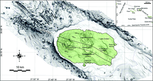
Terceira Island, together with Graciosa and S. Miguel Islands, are located along the axis of the Terceira Rift (), a complex hyper-slow oblique spreading centre that dominates the westernmost segment of Eurasian-Nubian plate boundary (Lourenço et al., Citation1998; CitationVogt & Jung, 2004). The island is made up of four strato-volcanoes, two of them believed to be extinct and affected by large collapses (Guilherme Moniz and Cinco Picos volcanoes, ) and two being considered still active (Pico Alto and Santa Bárbara volcanoes, ; CitationSelf, 1974, Citation1976; CitationCalvert, Moore, McGeehin, & Rodriguez da Silva, 2006; CitationGertisser et al., 2010). A main WNW-ESE-oriented fissural volcanic system, characterized subaerially by the alignment of cinder cones and eruptive fissures, crosses the island and extends into the submarine flanks of the island as the Serreta Ridge (). Two further major structural directions, trending WNW-ESE to NW-SE and NNW-SSE, are observed onland (Navarro, Lourenço, Chorowics, Mirando, & Catalão, Citation2009).
Figure 1. Shaded relief of the Terceira volcanic edifice (sun-light is azimuthal), contour interval: 200 m. Subaerial DTM from Instituto Geográfico do Exército (2001). In the inset, location of Terceira in the Azores archipelago.
Until now, little was known about the submarine sectors of Terceira Island except for the WNW Serreta Ridge, where an intermediate-depth submarine eruption occurred in 1998–2001, emitting lava balloons floating on the sea and ashy water (Gaspar et al., Citation2003 and references therein). In 2011, the FAIVI (Features of Azores and Italian Volcanic Islands) oceanographic cruise was performed offshore Terceira in the framework of the Eurofleets Project funded by European Community. The primary aim of the survey was to better characterize the morpho-bathymetric setting of the 1998–2001 eruptive area on the Serreta Ridge (Chiocci and FAIVI Team, Citation2012). Multibeam morpho-bathymetric data were also acquired around Terceira Island, aiming to produce the first bathy-morphological map, which we present in this work (main map in supplemental material). This map provides preliminary information on the submarine volcanism developed around the island as well as on tectonic and erosive-depositional features on its submarine flanks.
2. Methods
The FAIVI survey was subdivided into two legs. The first leg carried out onboard the launch Haliotis between 29 June and 11 July 2011, was aimed at acquiring morpho-bathymetric data in shallow water areas (10 m to 100 m wd) through the interferometric system Geoacoustics Geoswath, working at a frequency of 250 kHz. The second leg, carried out aboard the R/V L'Atalante between 7 and 20 September 2011, was aimed at acquiring morpho-bathymetric data in deep water by means of Simrad EM710 and EM122 multibeam systems, working at the frequencies of 70–100 kHz and 12 kHz, respectively. Bathymetric data were positioned using a differential global position system (DGPS) receiver and cover an area of about 2500 km2. Sound velocity data in the water column were collected daily and transducer calibration was repeated in both cruises. Data processing was performed through ‘ad hoc’ software (Caris Hips & Sips 6.1), encompassing the correction of attitude sensor data (roll, pitch, heave), the application of sound velocity profiles and tide corrections, as well as the use of statistical and geometrical filters to remove organized/not-organized noise. Processed data were gridded in order to obtain Digital Terrain Models (DTMs, hereafter) with a cell-size varying from 1 m in the first 100 m wd to 50 m in deep-water. The subaerial DTM (cell-size 10 m) was produced by the Instituto Geográfico do Exército (2001) and the final bathy-morphological map of the subaerial and submarine sector has a 50 m cell-size. The identification and mapping of geomorphic features was carried out on DTMs using Global Mapper. Contour maps, shaded relief maps with different sun altitude and azimuth, 3D-images and slope maps were extracted from the subaerial-submarine grid to aid the interpretation of recognized morphologies.
3. The bathymetric and geomorphological map
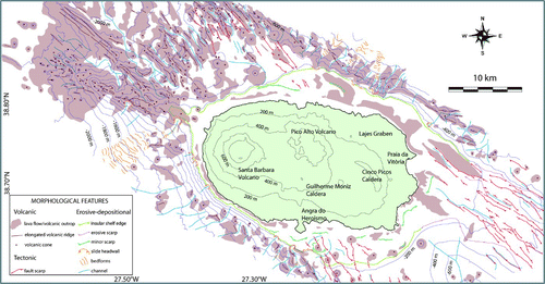
The high-resolution morpho-bathymetric data of the Terceira offshore reveal a highly complex and uneven morphology (), with an overall WNW-ESE elongation (∼70 km long and ∼30 km wide, down to a depth of ≈2500 mbsl, according to the limit of the survey). On the whole, the available data enabled us to identify different volcanic, tectonic and erosional/depositional features (). The lack of extensive ground-truth data (e.g. near-bottom visual observations and seafloor sampling) did not permit more specific classifications of mapped features. Below, we present a synthetic description of the main geomorphological features of the Terceira offshore.
Figure 2. General geomorphologic interpretation of the Terceira offshore (for details see text and main map in supplemental material).
3.1. Volcanic morphologies
A suite of volcanic morphologies is present off Terceira, including ridges, volcanic cones, and lava flows. The greatest variety of well-preserved volcanic morphologies occurs on the western offshore area of Terceira Island ( and ), where they mainly consist of NW-SE to WNW-ESE-trending elongated ridges with linear eruptive fissures on their top. Volcanic cones are relatively small (mostly with a base surface < 0.5 km2): they occur either isolated (with uneven or regular conical shapes) or in clusters, where they coalesce in long (up to 8 km) contiguous bodies. Dismantled and eroded cones are also found on the southern volcanic flank, as isolated sub-circular cones, frequently flat-topped and sometimes cut by fault scarps and by scars on their flanks ( and ). Lava flows are characterized by lobate structures and rough morphology. They are dominant in the nearshore sector of Terceira as they were extruded by subaerial eruptions and subsequently flowed over the insular shelf ().
3.2. Tectonic features
Several elongated fault scarps are observed cutting the seafloor in the northern, eastern and southern sectors off Terceira. The scarps are a few tens of metres high and several kilometres long in the southern and northern sectors, where they are preferentially oriented along NNW-SSE and NW-SE directions. A large number of rectilinear fault scarps are present in the eastern sector, extending for over 8.5 km to the Lajes graben in the northeastern sector of the island (). These scarps are tens-hundreds of metres high and preferentially oriented along the WNW-ESE direction.
3.3. Erosive/depositional features
Terceira Island is surrounded by a relatively flat insular shelf. The insular shelf is well-developed on the northern, eastern and south-eastern sectors, where it shows a shelf edge between 120 and 200 m wd, and has a variable width of 2–6 km ( and ). Conversely, it is very narrow in the western sector of the island (< 1 km), where the shelf break is located at 80–90 m wd. Minor scarps are also present on the shelf, often trending parallel to the shore and representing the depositional edge of terraced features (). The latter are very common features developed in the offshore areas of volcanic islands, where they have been interpreted as littoral deposits accumulated below the present-day wave-base level on steep coasts by means of storm-induced downwelling currents that transport sediment offshore (e.g. CitationChiocci & Romagnoli, 2004; CitationQuartau et al., 2012).
The other main erosive features are slide headwalls, erosive scarps and channelized features: the former vary in size from hundreds of metres to several kilometres wide and are observed mainly at the outer edge of the insular shelf and on the steepest areas of the volcanic ridges located in the western sector of the edifice. Most of the slide scars are the headwall of channelized features, having a width of 150–400 m and a length of 0.6–2 km. Slide headwalls are mainly concentrated in the southern and northern sectors. Erosive scarps are several kilometres-long steep features that represent the headwall of depressions or areas affected by widespread mass-wasting processes, as observed off the eastern coast of Terceira
Finally, crescent-shaped bedforms correspond to downslope asymmetric waves, with wavelength of 100–500 m and wave-height of 5–40 m; their crest-lines are roughly oriented perpendicular to the maximum slope and commonly concave-downslope. Two main crescent-shaped bedforms fields were observed within large channelized features off the northern coast of Terceira and south of the Serreta Ridge ( and ).
4. Conclusions
The new high-resolution morpho-bathymetric map of Terceira Island presented in this work allowed the mapping of different volcanic, tectonic and erosive-depositional features on the submarine flanks of the volcanic edifice. In particular, the western and north-western flanks are pervasively punctuated by different volcanic and tectonic features, while the eastern and south-eastern flanks, only partially investigated, have a smoother morphology in shallow water, and are cut by active tectonic scarps, while they show minor volcanic features.
The seafloor around Terceira appears to be characterized by a marked interaction between active tectonics and volcanic processes, as inferred by the alignment of fresh-looking volcanic and structural features along the main regional tectonic trends. These features are mostly clustered in the western and north-western sectors, where the last eruption (1999–2002) occurred (Gaspar et al., Citation2003). Conversely, while dismantling and large-scale mass-wasting processes are widely detected on the submarine flanks of other active volcanic islands (e.g. CitationBoudon, Le Friant, Komorowski, Deplus, & Semet, 2007; CitationCoombs, White, & Scholl, 2007; CitationMitchell, Masson, Watts, Gee, & Urgeles, 2002; CitationMoore, Normark, & Holcomb, 1994; CitationOehler, Lénat, & Labazuy, 2007; CitationRomagnoli, Casalbore, Chiocci, & Bosman, 2009a; CitationRomagnoli, Kokelaar, Casalbore, & Chiocci, 2009b), these features are subordinate in the offshore areas. They are mainly represented by small and medium-scale slope failures affecting the outer edge of the insular shelf, similar to that observed on nearby Faial Island (Quartau et al., Citation2012).
Because of its tectonic setting, the Azores Archipelago is highly vulnerable to tsunami hazards associated with landslides and seismic or volcanic triggers. The highest historically recorded tsunami run-up (11–15 m) in the Azores archipelago was recorded at Terceira Island on 1 November 1755 (Andrade et al., Citation2006); this tsunami was generated by a major earthquake and severely affected the other Azores islands and Lisbon. However, tsunamis induced by submarine volcanism or landslides are less common, despite the high potential displayed by the area (Andrade et al., 2006). The bathy-morphologic map of Terceira can provide useful insights for a first hazard assessment of the area and a reference base for more detailed volcano-tectonic studies.
Software
Caris Hips&Sips 6.1 was utilized to process multibeam data and to generate the marine DTM, while Global Mapper was used to visualize data through shaded relief maps, contour maps and slope gradient maps in order to perform morphological analyses, and extract morphological features from the DTM. The design of the final map was performed using CorelDRAW suite.
Main Map: Bathy-morphological Map of Terceira Island (Azores)
Download PDF (15.6 MB)Acknowledgements
The research was supported by the EU FP7 Eurofleets Project programme under the grant agreement 228344. We gratefully acknowledge the captain and the crew of L'Atalante R/V for their helpfulness and competence. We finally thank reviewers Aaron Micallef, Martin von Wyss and Claudio Lo Iacono for helpful comments, which significantly improved the paper and associated map.
Related Research Data
References
- Andrade , C. , Borges , P. and Freitas , M. C. 2006 . Historical tsunami in the Azores archipelago (Portugal) . Journal of Volcanology and Geothermal Research , 156 : 172 – 185 .
- Boudon , G. , Le Friant , A. , Komorowski , J.-C. , Deplus , C. and Semet , M. 2007 . Volcano flank instability in the Lesser Antilles Arc: Diversity of scale, processes, and temporal recurrence . Journal of Geophysical Research. , 112 : B08205 doi:10.1029/2006JB004674
- Calvert , A. T. , Moore , R. B. , McGeehin , J. P. and Rodriguez da Silva , A. M. 2006 . Volcanic history and 40Ar/39Ar and 14C geochronology of Terceira Island, Azores, Portugal . Journal of Volcanology and Geothermal Research , 156 : 103 – 115 .
- Chiocci, F. L., & FAIVI Team (2012). New insights into the 1998–2001“Serreta” eruption (Azores) from a marine geological investigation (FAIVI cruise, September 2011). 2012 El Hierro Conference, International Workshop on Oceanic island Volcanoes & Society, El Hierro, Canary Islands, Spain, 10–15 October 2012.
- Chiocci , F. L. and Romagnoli , C. 2004 . Terrazzi deposizionali sommersi nelle Isole Eolie . Memorie Descrittive della Carta Geologica d' Italia , 58 : 81 – 114 .
- Coombs , M. L. , White , S. M. and Scholl , D. W. 2007 . Massive edifice failure at Aleutian Arc volcanoes . Earth and Planetary Science Letters , 256 : 403 – 418 . doi:10.1016/j.epsl.2007.01.030
- Gaspar, J. L., Queiroz, G., Pacheco, J., Ferreira, T., Wallenstein, N., Almeida, H. A., & Coutinho, R. (2003). Basaltic lava balloons produced during the 1998–2001 Serreta Submarine Ridge eruption (Azores). In: Subaqueous Explosive Volcanism (J. White, D. Clague, J. Smellie, Eds.), American Geophysical Union, Geophysical Monograph 140, 205–212.
- Gertisser, R., Self, S., Gaspar, J. L., Kelley, S. P., Pimentel, A., Eikenberg, J., Barry, T. L., Pacheco, J. M., Queiroz, G., & Vespa, M. (2010). Ignimbrite stratigraphy and chronology on Terceira Island, Azores, in Groppelli, G., and Viereck-Goette, L., eds., Stratigraphy and Geology of Volcanic Areas: Geological Society of America Special Paper 464, p. 133–154, doi:10.1130/2010.2464(07).
- Lourenço , N. , Miranda , J. , Luís , J. , Ribeiro , A. , Mendes-Victor , L. , Madeira , J. and Needham , H. 1998 . Morpho-tectonic analysis of the Azores Volcanic Plateau from a new bathymetric compilation of the area . Marine Geophysical Research , 20 : 141 – 156 .
- Mitchell , N. C. , Masson , D. G. , Watts , A. B. , Gee , M. J. R. and Urgeles , R. 2002 . The morphology of the submarine flanks of volcanic ocean islands. A comparative study of the Canary and Hawaiian hotspot islands . Journal of Volcanology and Geothermal Research , 115 : 83 – 107 .
- Moore , J. G. , Normark , W. R. and Holcomb , R. T. 1994 . Giant Hawaiian landslides . Annual Review of Earth and Planetary Sciences , 22 : 119 – 144 .
- Navarro , A. , Lourenço , N. , Chorowics , J. , Mirando , J. M. and Catalão , J. 2009 . Analysis of geometry of volcanoes and faults in Terceira Island (Azores): Evidence for reactivation tectonics at the EUR/AFR plate boundary in the Azores triple junction . Tectonophysics , 465 : 98 – 113 .
- Oehler , J. F. , Lénat , J. F. and Labazuy , P. 2007 . Growth and collapse of the Reunion Island volcanoes . Bulletin of Volcanology , 70 : 712 – 742 . doi:10.1007/s00445-007-0163-0
- Quartau , R. , Tempera , F. , Mitchell , N. C. , Pinheiro , L. M. , Duarte , H. , Bates , R. and Monteiro , J. H. 2012 . Morphology of the Faial island shelf (Azores): The interplay between volcanic, erosional, depositional and mass-wasting processes . Geochemistry, Geophysics, Geosystems , 13 ( 4 ) : 30 doi:10.1029/2011GC003987
- Romagnoli , C. , Casalbore , D. , Chiocci , F. L. and Bosman , A. 2009a . Offshore evidence of large-scale lateral collapses on the eastern flank of Stromboli, Italy, due to structurally-controlled, bilateral flank instability . Marine Geology , 262 : 1 – 13 .
- Romagnoli , C. , Kokelaar , P. , Casalbore , D. and Chiocci , F. L. 2009b . Lateral collapses and active sedimentary processes on the northwestern flank of Stromboli volcano, Italy . Marine Geology , 265 : 101 – 119 .
- Self, S. (1974). Recent volcanism on Terceira, Azores (PhD Thesis). London University, Imperial College, 236 p.
- Self , S. 1976 . The Recent volcanology of Terceira, Azores . Journal of the Geological Society , 132 : 645 – 666 .
- Vogt , P. R. and Jung , W. Y. 2004 . The Terceira Rift as hyper-slow hotspot-dominated oblique spreading axis: A comparison with other slow-spreading plate boundaries . Earth and Planetary Science Letters , 218 : 77 – 90 .