
Abstract
Based on the statistics of the fifth and sixth censuses in China, this paper, which focuses on the spatial distribution characteristics of aging population in China's mega cities, examines the distribution of aging in Beijing, Shanghai, Guangzhou, and Wuhan. In this paper, an Aging Degree Index and an Aging Population Mean Center have been used to analyze the spatial distribution characteristics and spatial variation trends of aging population in mega cities. According to the research, the spatial distribution of aging population shows a faster development tendency of suburbanization from two different perspectives: one tendency is centrifugal spread associated with seniors who are moving from the city center to outer suburb areas, and the other is center concentration where the seniors who lived in the outer suburb areas are moving towards the city center.
1. Introduction
In 2010, the proportion of people aged 60 and above was 13.26%, 2.93% higher than the 2000 census, of which those 65 years and older account for 8.87%, 1.91% higher than the 2000 census. With the rapid aging of the population, the psychological, economic, health, and social environments of the elderly have undergone a significant change, and a lot of problems have arisen with it. Nowadays, the aging problems have begun to reflect a variety of associations with urban space; for instance, it has played a significant impact on the urban structure, urban form, land use, etc. In the face of the major demographic shift and aging problems, the urban development still lags far behind. It is an important and urgent strategic task for the Chinese government to think about what kind of residential environment should be provided for the seniors, and what kind of urban spatial development policy should be developed to meet their needs.
Recently, many countries have proposed some theoretical and practical policy initiatives to solve the problems associated with a rapidly aging population, including Healthy Aging, Active Aging, Aging in Place, etc. (CitationLui, Everingham, Warburton, Cuthill, & Bartlett, 2009). In 1986, The World Health Organization (WHO) launched a ‘Healthy Cities Project’ emphasizing the relationship between health and the built environment as well as the role of local government in promoting active living environments for all ages. In 2002, the WHO advanced its version of ‘Active Aging’ at the Second United Nations World Assembly on Aging held in Madrid, and recently launched a ‘Global Age-Friendly Cities Project’ in which 33 cities from 22 countries engaged in a community planning process which linked ideas about smart growth with ideas about how to help the elderly remain active and engaged in their communities with appropriate transportation, housing, health care, and other services (CitationSidorenko & Walker, 1999).
At the regional level, various studies have also been undertaken by geographers on the global pattern of aging population (CitationAndrews, Cutchin, McCracken, Phillips, & Wiles, 2007). At the subnational level, there has been considerable work on the geographical dimensions of aging in the Russian Federation, Canada, the USA, the UK, and Poland (CitationHeleniak, 2003; CitationMoore & Pacey, 2004; CitationWalford & Kurek, 2008; CitationWarnes, 1990). At the city level, studies have shown that aging populations are located in urban centers and villages (CitationSomenahalli, Shipton, & Bruce, 2010), and the residential segregation of aging population in metropolitan areas is very serious (CitationRogerson, 1998; CitationSmith, 1998). Internationally, investigations of the spatial dynamics of aging have made considerable headway; however, research in China is still in its infancy.
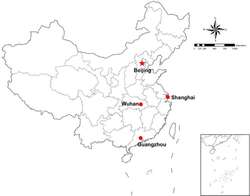
There is an increasing number of spatial problems associated with the aging of Chinese cities. For example, the aging population has highly concentrated in city centers and also developed rapidly in the suburbanized areas of cities and rural areas; nevertheless, the elderly facilities are inadequate, unequally distributed, and absent. The main reason is that urban planning in China lags behind the pace of population aging. To address this problem, our purpose is to examine the spatial distribution of characteristics associated with aging populations in cities. Since aging problems are prominent in China's mega cities, it is important for this paper to choose the most developed and densely populated mega cities in south, north, east, and middle of China as typical study objects (). Based on the statistics of the fifth and sixth censuses in China, this paper, which focuses on the spatial variation of aging populations in China's mega cities, applies Geographic Information System methods to map the spatial distribution of aging populations in Beijing, Shanghai, Guangzhou, and Wuhan using ArcGIS 10.1. The spatial boundary used for representing the administrative divisions of each city are provided by the planning bureau of local governments, and used to apply the Aging Population Mean Center (CitationWu, Mohamed, & Wang, 2011) to test the variation characteristics and tendency of aging population, so as to provide empirical support for the Chinese government to develop a policy to deal with the aging problems in mega cities, including elderly facilities planning, public space, transport planning, etc.
Figure 1. Location of the four mega cities in China.
2. Materials and methods
The population statistics of this analysis come from the China population of 2000 and 2010. According to the Chinese standard and the international standard, this paper mainly measures the aging level by Aging Degree Index which is defined as the ratio of people aged above 65 among the total population. Moreover, the aging level has more connotations including the Aging Degree Index, the Median Age Index, etc. Since the population statistics of China in 2010 have not been published, this paper only focuses on the acquirable population data aged over 65 to measure the aging level by using the Aging Degree Index. Based on the definition mentioned earlier, the population structure is divided into four types: the Young, the Adult, the Aged, and the Super-aged. If the Aging Degree Index is below 4%, the district is defined as the Young; between 4% and 7%, the Adult; above 7% but below 15%, the Aged; and 15% above, the Super-aged.
The Aging Population Mean Center is used to test the spatial variation of the aging population; it is far away from the sparsely populated area and approaches the densely populated area, its moving track during the limited history shows the historical process of spatial distributional variation of the population, and its moving direction shows the expansion orientation of population distribution. Generally, the position of the population center is indicated as:
where X and Y are the projected coordinates for calculating the inhabitants center; Pi is the population of the site i; Xi and Yi are the projected coordinates of the site i, respectively.
Meanwhile, the conceptions of centrifugal spread and center concentration are indicated as:
where D2000 and D2010 indicate, respectively, the distance from each district to the city center of the aging population mean center in 2000 and 2010. xi and yi are the coordinates of the aging population mean center of each district in 2000, and xj and yj are the coordinates of the aging population mean center of each district in 2010. x10 and y10 indicate the coordinates of the aging population mean center of the city center in 2010. If D2010 is greater than D2000, the spatial variation of the population reflects centrifugal spread, otherwise, center concentration (see Main Map).
3. Spatial variation characteristics of the aging population in China's mega cities
3.1. Spatial variation of population aging in Beijing
The spatial distribution map of population aging in Beijing shows that the aging population mean center changes only a little, in which the aging population remained in Chaoyang District from 2000 to 2010, indicating that the variation tendency of the aging population in Beijing maintains center concentration ( and ). It also shows that the variation tendency of the aging population in the center of Beijing has not changed yet, while centrifugal spread is identified in suburban areas, with the exception of Haidian District, and center concentration is identified in the outer suburban areas with the exception of Shunyi District and Miyun County ().
Figure 2. Change of the aging population mean center in Beijing region and district.
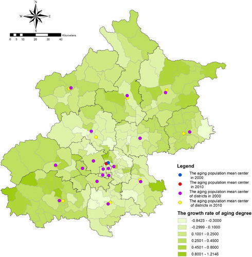
Figure 3. Change of population aging degree on the street block level in Beijing.
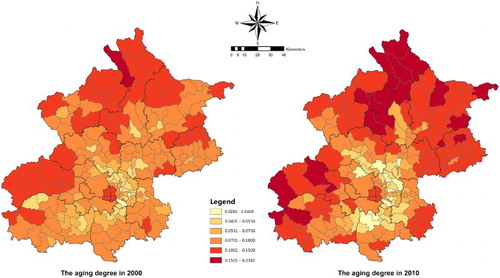
Table 1. The variation tendency of the aging population in Beijing.
3.2. Spatial variation of population aging in Shanghai
The spatial distribution map of population aging in Shanghai shows that the change of the aging population mean center is subtle, in which population aging has remained in Xuhui District from 2000 to 2010, indicating that the variation tendency of the aging population in Shanghai maintains center concentration ( and ). It also shows that the variation tendency of population aging in the center of Shanghai is characterized by centrifugal spread, while mainly center concentration is the dominant mode in suburban areas with the exception of Jinshan District, Pudong New District, and Chongming County ().
Figure 4. Change of the aging population mean center in Shanghai region and district.
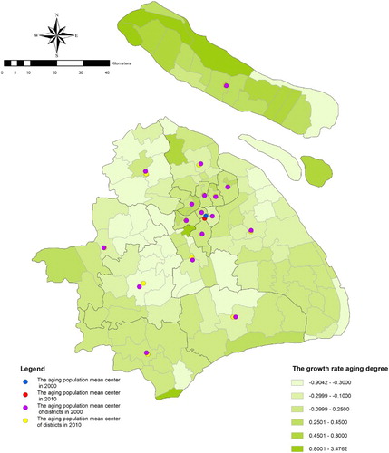
Figure 5. Change of population aging degree on the street block level in Shanghai.
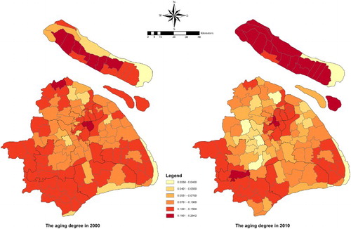
Table 2. The variation tendency of the aging population in Shanghai.
3.3. Spatial variation of population aging in Guangzhou
The spatial distribution map of population aging in Guangzhou shows that the population aging mean center changes only a little, in which population aging remained in the Changxing street block of Tianhe District from 2000 to 2010. This indicates that the variation tendency of the aging population in Guangzhou maintains center concentration ( and ). It also shows that the variation tendency of population aging in the center of Guangzhou is centrifugal spread and center concentration. However, small spatial variation can be found in the city center, and mainly center concentration in the suburb areas except Nansha District ().
Figure 6. Change of the aging population mean center in Guangzhou region and district.
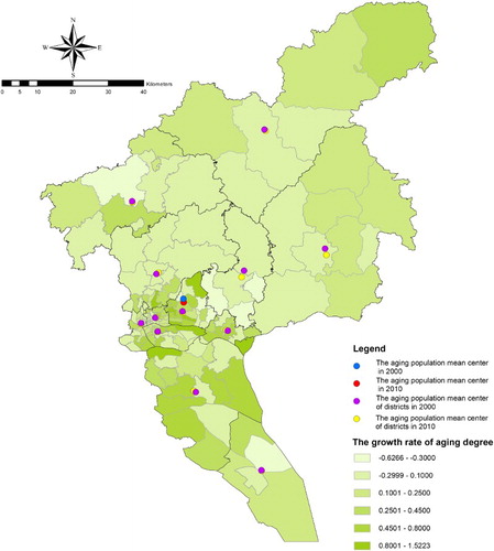
Figure 7. Change of population aging degree on the street block level in Guangzhou.
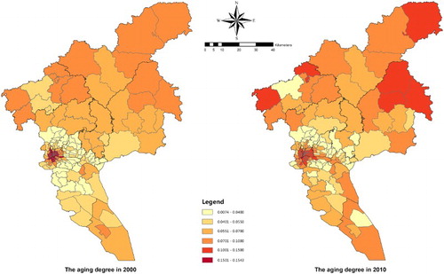
Table 3. The variation tendency of the aging population in Guangzhou.
3.4. Spatial variation of population aging in Wuhan
The spatial distribution map of population aging in Wuhan shows that the population aging mean center has remained nearly unchanged, in which population aging remained in the Erqi street block of Tianhe District from 2000 to 2010, indicating that the variation tendency of population aging in Wuhan maintains center concentration ( and ). It also shows that the variation tendency of population aging in the center of Wuhan is mainly centrifugal spread except Wuchang District and Hongshan District, while center concentration and centrifugal spread are dominant in the suburb areas ().
Figure 8. Change of the aging population mean center in Wuhan region and district.
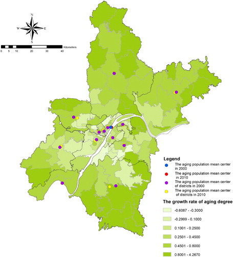
Figure 9. Change of population aging degree on the street block level in Wuhan.
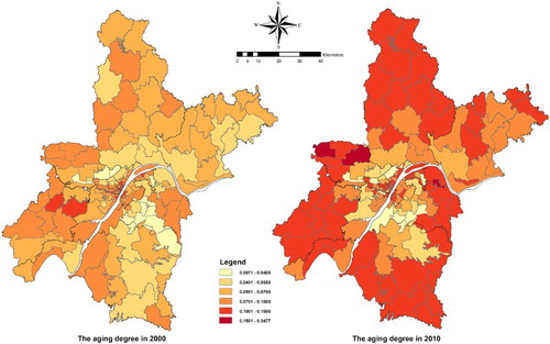
Table 4. The variation tendency of the aging population in Wuhan.
4. Results and conclusion
The maps of the spatial distribution of population aging in China's mega cities, such as Beijing, Shanghai, Guangzhou, and Wuhan, indicate different kinds of spatial dimensions unique to each place. In Beijing, aging follows the mode of circular spread, concentrating in the city center, reducing in the suburb areas, and increasing in the outer suburb areas, and forms Super-aged districts in some parts of outer suburbs. Following the mode of circular expansion, axis expansion, and enclave expansion, the aging districts in Shanghai have also followed the outward expansion, and formed Super-aged districts at the edge of the city center as well as parts of the outer suburbs. Aging districts in Guangzhou have expanded outwards in a circular mode as well, and formed some aging clusters in outer suburbs. As for Wuhan, aging districts have expanded outwards along the traffic axis and formed some Super-aged districts in parts of the outer suburbs.
In relation to these differences, there are also some similarities that exist. The city center is a concentrated area for aging populations with very small spatial variation in the past decade. The suburban areas are the places where the aging degree has decreased a lot, because a large number of districts have changed from aging districts to adult districts or young districts, and the spatial variation of aging populations is one of centrifugal spread. Moreover, the outer suburb districts have become the largest aging degree areas, and the spatial variation of population aging has followed trends of concentrating towards the city center. These characteristics are influenced by various factors, such as socio-economic levels, urban morphology, urban planning policy, etc., of which the main factor is the urban structure. With the rapid social and economic development of Beijing and Guangzhou over the past three decades, the single center structure makes these cities develop into circular mode. Nevertheless, since Shanghai and Wuhan are mainly combined conglomeration structured cities, aging districts usually expand along the traffic axis. Thus, it can be seen that the suburbanization of aging populations in China's mega cities is quite obvious, which means aging populations will tend to expand toward the urban fringe and outer suburban areas.
Although the spatial variation characteristics of population aging in China's mega cities are diverse, the mechanisms are the same in many ways. First, the large-scale selective renewal in China's mega cities has attracted aging populations with high social status and steady income to concentrate in the city center. Second, motivated by the multiple alterations of urban spatial structures, the aging populations who originally lived in old residential communities, danwei communities, or urban villages were forced to move to suburban areas. Third, the aging populations have to concentrate in outer suburban areas because of new problems associated with vacant villages in which labor forces migrated into big cities with only the elderly and the young left in rural areas. Finally, the social space differentiation of aging populations is aggravated by the polarization of types of professions and income levels.
In general, the spatial variations of population aging in China's mega cities represent a centrifugal spread trend with faster spread speed from outer suburb areas to the urban fringe than from the city center to the edge. It is important for the Chinese government to deal with the problem of the rapid suburbanization of the aging populations in mega cities in the future.
Software
Several software packages were used in development of the maps. The population data were collected and maintained in a Microsoft Access database. The spatial results were developed in ESRI ArcGIS 10.1, where we built the GIS database and prepared the base map.
Mapping Spatial Variation of Aging Population in China's Mega Cities
Download PDF (3 MB)Acknowledgements
The authors would like to thank the Wuhan Land Resources and Planning Information Center, Wuhan Bureau of Land Resources and Planning for providing the population data.
Additional information
Funding
Related Research Data
References
- Andrews, G. J., Cutchin, M., McCracken, K., Phillips, D. R., & Wiles, J. (2007). Geographical gerontology: The constitution of a discipline. Social Science & Medicine, 65(1), 151–168. doi:10.1016/j.socscimed.2007.02.047
- Heleniak, T. (2003). Geographic aspects of population aging in the Russian federation. Eurasian Geography and Economics, 44(5), 325–347. doi:10.2747/1538-7216.44.5.325
- Lui, C. W., Everingham, J. A., Warburton, J., Cuthill, M., & Bartlett, H. (2009). What makes a community age-friendly: A review of international literature. Australasian Journal on Ageing, 28(3), 116–121. doi:10.1111/j.1741-6612.2009.00355.x
- Moore, E. G., & Pacey, M. A. (2004). Geographic dimensions of aging in Canada, 1991–2001. Canadian Journal on Aging/Revue Canadienne Du Vieillissement, 23, S5–S21. doi:10.1353/cja.2005.0037
- Rogerson, P. A. (1998). The geography of elderly minority populations in the United States. International Journal of Geographical Information Science, 12(7), 687–698. doi:10.1080/136588198241608
- Sidorenko, A., & Walker, A. (1999). The Madrid international plan of action on ageing: From conception to implementation. Ageing and Society, 24, 147–165. doi:10.1017/s0144686×03001661
- Smith, G. C. (1998). Change in elderly residential segregation in Canadian metropolitan areas, 1981–91. Canadian Journal on Aging/Revue Canadienne Du Vieillissement, 17(1), 59–82. doi:10.1017/s0714980800010357
- Somenahalli, S. V. C., Shipton, M. D., & Bruce, D. (2010). Investigating the spatial distribution of the elderly and its implications for service provision in Adelaide Metropolitan Area. Paper presented at the 33rd Australasian transport research forum, ATRF 2010, September 29, 2010–October 1, 2010, Canberra, ACT, Australia.
- Walford, N. S., & Kurek, S. (2008). A comparative analysis of population ageing in urban and rural areas of England and Wales, and Poland over the last three census intervals. Population Space and Place, 14(5), 365–386. doi:10.1002/psp.488
- Warnes, A. M. (1990). Geographical questions in gerontology – needed directions for research. Progress in Human Geography, 14(1), 24–56. doi:10.1177/030913259001400103
- Wu, J., Mohamed, R., & Wang, Z. (2011). Agent-based simulation of the spatial evolution of the historical population in China. Journal of Historical Geography, 37(1), 12–21. doi:10.1016/j.jhg.2010.03.006