
Abstract
We present the results of a detailed bathymetric survey of Pozzuoli Bay (Gulf of Naples, Italy). This shallow marine area, along with the Campi Flegrei inland, is a highly active volcanic district in the coastal zone of SW Italy. The area has been active since at least 78 ka B.P., and is structurally dominated by a caldera collapse (∼8 km in diameter) associated with the eruption of the Neapolitan Yellow Tuff (NYT), a 30–50 km3 dense rock equivalent (DRE) ignimbrite dated ∼15 ka B.P. The main cartographic product consists of a 1:10,000 scale morpho-bathymetric map of Pozzuoli Bay, derived from 1 m cell-size, colour hill-shaded, digital terrain model of the seafloor. Multibeam bathymetry data reveal the precise extent of Roman underwater archaeological remains located in the N–NW infralittoral zone of the Bay. Morphometric analysis allowed for the development of thematic representations, including slope and aspect maps. A complete data set of active fluid vents seafloor locations were also recorded during the survey and reported in the final map. The multibeam bathymetric survey illustrated in this study provides an unprecedentedly detailed image of the seafloor morphology of Pozzuoli Bay and represents a contribution to the understanding of the dynamic evolution of the Campi Flegrei caldera, a high-risk volcanic area densely populated by almost one million people.
1. Introduction
Multibeam swath bathymetry technologies have significantly improved during the last 20 years allowing for the possibility of producing ultra high-resolution images of seafloor morphology. In particular, a new generation of high-resolution bathymetric maps has resulted in a renewed interest in the better understanding of the morphological expression and dynamics of south-eastern Tyrrhenian submarine volcanism over the last few years (e.g. CitationBosman, Casalbore, Romagnoli, & Chiocci, 2014; CitationCasalbore, Bosman, Romagnoli, Di Filippo, & Chiocci, 2014; CitationCasalbore, Romagnoli, Chiocci, & Frezza, 2010; CitationChiocci & De Alteriis, 2006; CitationDe Alteriis & Violante, 2009; CitationPassaro et al., 2010; CitationPassaro, Milano, Sprovieri, Ruggieri, & Marsella, 2011a; CitationRomagnoli, Casalbore, Bosman, Braga, & Chiocci, 2013; CitationSacchi et al., 2014; CitationVentura, Milano, Passaro, & Sprovieri, 2013).
The Campi Flegrei district is an active volcanic area that covers about 200 km2 of the coastal zone of SW Italy, a large part of which develops off the Gulf of Naples, and is characterized by at least one large caldera collapse structure. The caldera is represented by a quasi-circular area of ∼8 km in diameter in the central sector of the Campi Flegrei, including the Pozzuoli inland area and Pozzuoli Bay (CitationCarlino & Somma, 2010; CitationDello Iacono, Zollo, Vassallo, Vanorio, & Judenherc, 2009; CitationDe Natale et al., 2006; CitationOrsi, De Vita, & Di Vito, 1996; CitationRosi & Sbrana 1987; CitationSacchi et al., 2009; CitationScandone, Bellucci, Lirer, & Rolandi, 1991; CitationSacchi et al., 2014).
Despite considerable research work and numerous geophysical surveys conducted in the Campi Flegrei inland area over the last 30 years, the detailed offshore morphology of the Neapolitan Yellow Tuff (NYT) caldera collapse structure and resurgence, and hydrothermal activity are still poorly understood. This is mostly because of the intrinsic limitations associated with the low resolution and poor geo-referencing accuracy of many published bathymetric data sets (e.g. CitationD'Argenio, Pescatore, & Senatore, 2004; CitationDi Vito et al., 1999; CitationFevola, Fusi, & Mirabile, 1993; CitationFusi, Mirabile, Camerlenghi, & Ranieri, 1991; CitationOrsi et al., 1996; CitationMilia, 1998; CitationPescatore, Diplomatico, Senatore, Tramutoli, & Mirabile, 1984).
In this study, we present the results of a very high-resolution multibeam bathymetric survey conducted in Pozzuoli Bay in June of 2013. The resulting seafloor map provides an unprecedentedly detailed image of the shallow structure of the NYT caldera collapse and resurgence. In addition, the results of the swath bathymetric survey also enabled the recognition and mapping of active fluid vents (AFV), by using echosounder profiles of the water column (e.g., CitationPassaro et al., 2014). The study of AFV is of particular interest in this area, for the characterization of the feeding magma system as well as for the understanding of genetic processes and rising mechanism of volcanic fluids. In fact, AFV have long been recognized in the emerged Campi Flegrei sectors (e.g. CitationAiuppa et al., 2013; CitationChiodini et al., 2010; CitationGiacomelli & Scandone, 2012; CitationTassi et al., 2013; CitationVaselli, Tassi, Tedesco, Poreda, & Caprai, 2011). However, occurrence of the spotty marine vents has had less recognition so far (see CitationGiacomelli & Scandone, 2012, and references therein). The morpho-bathymetric map of Pozzuoli Bay provides a first onshore–offshore cartographic basemap for the definition of multi-risk scenarios and coastal zone management actions for the active volcanic area of Campi Flegrei.
2. Geological background
Volcanic activity of the Campi Flegrei spans from the late Quaternary (CitationDi Girolamo et al., 1984; CitationRosi & Sbrana, 1987; CitationLirer, Luongo, & Scandone, 1987; CitationDi Vito et al., 1999; CitationRolandi, Bellucci, Heizler, Belkin, & De Vivo, 2003) and is characterized by at least one large caldera collapse structure, produced during the eruption of the NYT, a 30–50 km3 dense rock equivalent (DRE) ignimbrite dated at ∼15 ka BP (CitationDeino, Orsi, de Vita, & Piochi, 2004).
Several studies have proposed that the onset of the NYT caldera was preceded by a larger caldera collapse during the eruption of the 100–200 km3 DRE Campania Ignimbrite (CI) 39 ka. BP (CitationLirer et al., 1987; CitationRosi & Sbrana, 1987; CitationOrsi et al., 1992; CitationDe Vivo et al., 2001; CitationDeino et al., 2004), although recent investigations suggest that the CI may have originated instead from fissural eruptions that occurred within the Campania Plain (CitationRolandi et al., 2003).
The NYT eruption was followed by almost 70 explosive and effusive eruptions among which the most representative Plinian eruptions were Agnano-Pomici Principali, 10 ka (CitationDi Vito et al., 1999) and Agnano-Monte Spina, 4.1 ka (Citationde Vita et al., 1999). Products of hydromagmatic eruptions are mainly monogenetic tuff cones and tuff rings, while effusive eruptions are only represented by a few lava domes (CitationRosi, Sbrana, & Principe, 1983).
The last eruption was of Monte Nuovo, (1538 A.D) with 0.03 km3 of erupted products (CitationRosi et al., 1983). After this eruption, the floor of Campi Flegrei caldera was affected by a slow and regular subsidence. In more recent times, two bradyseismic crises accompanied by seismic events of low magnitude occurred in the area. The first was in 1969–1972, and the second was in 1982–1984. These episodes produced an overall 3.5 m of ground uplift at the points of maximum uplift in the town of Pozzuoli (CitationBarberi, Hill, Innocenti, Luongo, & Treuil, 1984; CitationDel Gaudio, Aquino, Ricciardi, Ricco, & Scandone, 2010), with very shallow recorded microseismicity triggered in response to fluid motion episodes (CitationD'Auria et al., 2011).
Since November 2004, a new uplift phase started with about 0.04 m of uplift by the end of October 2006 (CitationDel Gaudio et al., 2010; CitationTroise et al., 2007). The magmatic system is still active as attested by diffuse degassing zones and hydrothermal vents (fumaroles) in the areas of Solfatara crater and Pisciarelli. Petrologic and geophysical evidence (e.g. CitationBattaglia, Troise, Obrizzo, Pingue, & De Natale, 2006; CitationCaliro, Chiodini, & Paonita, 2014; CitationDe Natale et al., 2006) suggest (for the Campi Flegrei caldera) the occurrence of a sill-like reservoir of fluids at a depth of 3–4 km, associated with a deeper feeding magma reservoir located at a depth of ca. 8 km.
3. Data and methods
The bathymetric survey of Pozzuoli Bay was carried out in June of 2013 on board the ‘Idrosfera’ catamaran using a Reson Seabat 8101 multibeam. This echosounder is characterized by a 240 kHz acoustic source frequency, 101 beams and 150° of pulse width, and is particularly suitable for high-resolution mapping in shallow water (up to 100 m depth). The use of the V101 Hemisphere differential global positioning system receiver coupled with FOG-200 motion sensor ensured sub-metre precision for beam positioning during data acquisition. A tidal correction derived from the national tide gauge network was also applied to increase vertical resolution. A set of 18 sound velocity profiles were acquired during the survey. In addition, a hull-mounted sound velocity profiler sensor was used for continuous, real-time measurements of sound velocity and temperature for the uppermost part of the water column.
After data processing, depth measurements were interpolated to a digital terrain model (DTM) with 1-m grid resolution. During multibeam acquisition, fluid emissions at the seafloor were mapped using the 50/200 kHz double frequency Furuno FCV620 5.6-Inch Waterproof Fishfinder that can detect acoustic anomalies inside the water column. The location of all major AFV recognized at the seafloor during the survey was included in the cartographic representation presented in this study.
In order to complete the Main Map, the newly obtained DTM was integrated with another marine DTM (5X5 m grid cell size) acquired by the IAMC-CNR in 2002 on board of R/V ‘Tethis', with a Reson Seabat 8111 (100 kHz) echosounder for sectors deeper than 80 m below sea level (bsl), off Pozzuoli Bay. Finally, the marine DTM was merged with a 5X5 m grid of the Campi Flegrei coastal area, acquired by the Campania Region in 2004 (Main Map).
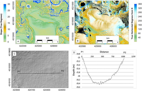
For the interpolated marine/terrestrial DTM standard geomorphologically derived products were computed, including (a) a slope map ((a)); (b) an aspect map ((b)).
Seafloor areas reported in the main morpho-bathymetric map, as well as in –, locally display an apparently rugged-shaped, ripple-like morphology, possibly as a consequence of an ineffective motion reference units correction. This is, however, an artefact, resulting from small vertical oscillations of depth measurements that produce fake seafloor undulations aligned along swath, perpendicularly to the ship heading ((c)). Shaded relief is computed using gradient over contiguous cells, which may produce noise due to gradient computation on relatively flat areas. Indeed, elevation profiles extracted from the DTM reveal that the magnitude of ripple-like noise does not exceed 0.05 m (0.02 on average; (d)).
Figure 1. (a) DTM of Pozzuoli Bay. Projection is UTM (33); Datum is WGS84. (Lakes: AL = Averno, LL = Lucrino; Craters: MN = Monte Nuovo, GA = Gauro; AS = Astroni; CI = Cigliano; SO = Solfatara; AG = Agnano; AS = Astroni); Inset (b) Archaeological remains in the marine sector in front of Baia (VdP = Villa dei Pisoni; BeC = Baianus Lacus entry channel); Inset (c) Archaeological remains in the marine sector in front of Pozzuoli (PI = Portus Iulius; PIEC = Portus Iulius Entry Channel).
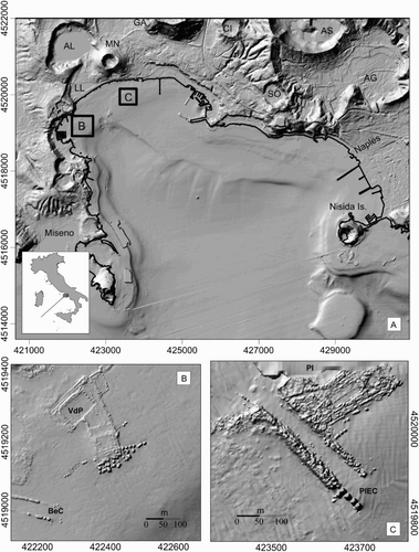
Figure 2. (a) Slope map; (b) Aspect map; (c) Seafloor DEM sample displaying apparent rugged-shaped, ripple-like morphology, actually due to an artefact (fake seafloor undulations aligned along swath, perpendicular to the ship heading); (d) bathymetric profile P1–P2 showing shape and magnitude of ripple-like noise.
The final map was created using universal transverse mercator (UTM) conformal projection and WGS84 reference ellipsoid. The vertical datum (0 m elevation) has been referred to the average level of the low spring tides of Pozzuoli Bay.
4. Results, discussion and conclusions.
The cartographic product illustrated in this study is based on a 1-m grid resolution marine DTM of Pozzuoli Bay at 1:10,000 scale and provides a detailed image of the onshore–offshore morphology of the Campi Flegrei coastal volcanic district (). The final marine DTM covers about 30 km2, in a water depth range of 1–110 m bsl. In the area, slope varies between 0° and 80° ((a)), with higher values mostly concentrated around younger volcanic cones (e.g. Monte Nuovo), while in the marine sector, gentle slopes prevail, and several terraced surfaces mostly oriented N130°E occur ((b)). Stepped terraced areas on the easternmost side of the Bay are up to 1.5 km wide, while in the west, their width is as small as 0.5 km.
It is worth noting that Pozzuoli Bay is particularly important in terms of underwater archaeology. The whole coastal area was subject to remarkable anthropic influence during Roman times, resulting in the establishment of two settlements, Portus Iulius to the East (the present-day Pozzuoli area) and Baianus Lacus to the West (Baia). The remains of these settlements are presently lying under the sea, at water depths between a few meters and 15 m bsl ((a)–1(c), as a consequence of both subsidence of the NYT caldera floor and sea-level rise. Baianus Lacus included villas and luxury buildings, like Villa dei Pisoni (VdP, (b)), and was the site of several thermal complexes (CitationCarlino, Somma, Troise, & De Natale, 2012). In the easternmost sector of the Bay (the ancient Puteoli), underwater remains are represented by the Portus Iulius complex ((c)) that was originally a military district later converted into a commercial settlement. The abandonment of the military site was likely a consequence of progressive burial of the old harbour area, due to the seaward accumulation, by the river network, of loose volcaniclastic material that was mantling the slopes of Campi Flegrei during the first two centuries after Christ.
A long breakwater, called the Via Herculanea connected Portus Julius to Baianus Lacus, and separated the anthropic embayment of Lucrino (presently Lake Lucrino) from the open sea (CitationPassaro et al., 2013). Later, the morphology of the entire area underwent dramatic change after the Monte Nuovo eruption, in 1538 A.D.
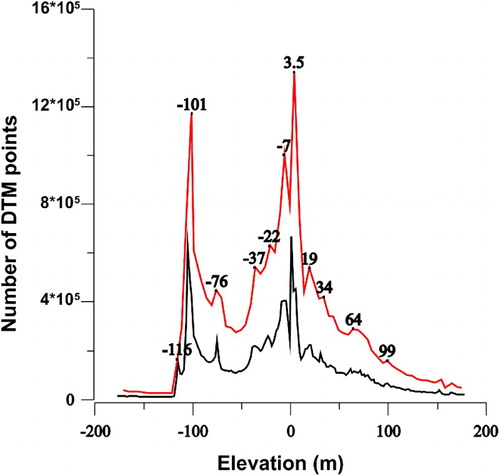
A histogram of elevation was computed in order to highlight the average distribution of sub-horizontal (terraced) surfaces that, in this type of plot, show positive peaks in the distribution (CitationPassaro et al., 2011a; CitationPassaro, Ferranti, & De Alteriis, 2011b). Terraced surfaces occur at water depths of 116, 101, 76, 37, 22 and 7 m and also above sea level at 4, 19, 34, 64 and 98 m in altitude (). These surfaces are likely the result of phases of dynamic equilibrium between seafloor erosion, ground deformation (uplift and/or subsidence), sea-level fluctuations and sedimentary input from the coast.
Figure 3. Elevation histogram derived from the DTM data, illustrating statistical distribution and average elevation of planar (terraced) surfaces. Red line indicates the envelope of grid cell elevations computed at 1 m; black line shows the same distribution computed at 3 m.
The spatial distribution of AFV detected at the seafloor during the bathymetric survey suggests that AFV are preferentially distributed along linear patterns, locally parallel to the coastline segments, and may mirror slope and/or aspect changes.
ORCID
Salvatore Passaro http://orcid.org/0000-0002-3045-9002
Software
PDS2000 (Teledyne RESON) was used to process the multibeam data and generate the marine DTM. DraftSight 32 (Dassault Systèmes) freeware was used to edit vector maps, export thematic layers and add toponyms and symbols (e.g. breakwaters, jetties, buoys). Quantum GIS ‘Dufour’ (ver. 2.0.1) was adopted for managing and editing geographical data, computing slope and aspect maps and creating the final map design.
HIGH RESOLUTION MORPHOBATHYMETRY OF POZZUOLI BAY, SOUTHERN ITALY
Download PDF (23.2 MB)Acknowledgements
The high-resolution bathymetric survey of Pozzuoli Bay was carried out in June of 2013 by Geomarine srl, Senigallia (AN), Italy, under the coordination of INGV, Napoli and IAMC-CNR, Napoli. The final DTM was integrated with a marine DTM (5X5 m grid cell size) acquired by the IAMC-CNR in 2002 within the frame of the CARG Project (Regione Campania and ISPRA) along with a DTM of the inland area (5X5 m grid cell size), acquired for the ORCA Project (2004) of the Campania Region.
Funding
Financial support for this research was provided by the Programma Operativo Nazionale (PON) – Ricerca e Competitivita’ 2007–2013 funded by the Italian Ministry of University and Research – Project MONICA (PON01_01525).
Related Research Data
References
- Aiuppa, A., Tamburello, G., Di Napoli, R., Cardellini, C., Chiodini, G., Giudice, G., … Pedone, M. (2013). First observations of the fumarolic gas output from a restless caldera: Implications for the current period of unrest (2005–2013) at Campi Flegrei. Geochemistry, Geophysics, Geosystems, 14(10), 4153–4169. doi: 10.1002/ggge.20261
- Barberi, F., Hill, D. P., Innocenti, F., Luongo, G., & Treuil, M. (Eds.). (1984). The 1982–1984 Bradyseismic crisis at Phlegrean fields (Italy). Bulletin of Volcanology, 47, 173. doi: 10.1007/BF01961546
- Battaglia, M., Troise, C., Obrizzo, F., Pingue, F., & De Natale, G. (2006). Evidence for fluid migration as the source of deformation at Campi Flegrei caldera (Italy). Geophysical Research Letters, 33, L01307. doi: 10.1029/2005GL024904
- Bosman, A., Casalbore, D., Romagnoli, C., & Chiocci, F. L. (2014). Formation of an ‘a’ā lava delta: Insights from time-lapse multibeam bathymetry and direct observations during the Stromboli 2007 eruption. Bulletin of Volcanology, 76(7), 1–12. doi: 10.1007/s00445-014-0838-2
- Caliro, S., Chiodini, G., & Paonita, A. (2014). Geochemical evidences of magma dynamics at Campi Flegrei (Italy). Geochimica et Cosmoschimica Acta, 132, 1–15. doi: 10.1016/j.gca.2014.01.021
- Carlino, S., & Somma, R. (2010). Eruptive versus non-eruptive behaviour of large calderas: The example of Campi Flegrei caldera (southern Italy). Bulletin of Volcanology, 72(7), 871–886. doi: 10.1007/s00445-010-0370-y
- Carlino, S., Somma, R., Troise, C., & De Natale, G. (2012). The geothermal exploration of Campanian volcanoes: Historical review and future development. Renewable and Sustainable Energy Reviews, 16(1), 1004–1030. doi: 10.1016/j.rser.2011.09.023
- Casalbore, D., Bosman, A., Romagnoli, C., Di Filippo, M., & Chiocci, F. L. (2014). Morphology of Lipari offshore (southern Tyrrhenian Sea). Journal of Maps. doi: 10.1080/17445647.2014.980858
- Casalbore, D., Romagnoli, C., Chiocci, F. L., & Frezza, V. (2010). Morpho-sedimentary characteristics of the volcaniclastic apron around Stromboli volcano (Italy). Marine Geology, 269, 132–148. doi: 10.1016/j.margeo.2010.01.004
- Chiocci, F. L., & De Alteriis, G. (2006). The Ischia debris avalanche: First clear submarine evidence in the Mediterranean of a volcanic island prehistorical collapse. Terra Nova, 18(3), 202–209. doi: 10.1111/j.1365-3121.2006.00680.x
- Chiodini, G., Caliro, S., Cardellini, C., Granieri, D., Avino, R., Baldini, A., … Minopoli, C. (2010). Longterm variations of the Campi Flegrei, Italy, volcanic system as revealed by the monitoring of hydrothermal activity. Journal of Geophysical Research, 115, B03205. doi: 10.1029/2008JB006258
- D'Argenio, A., Pescatore, T., & Senatore, M. R. (2004). Sea-level change and volcano-tectonic interplay. The Gulf of Pozzuoli (Campi Flegrei, Eastern Tyrrhenian Sea) during the last 39 ka. Journal of Volcanology and Geothermal Research, 133, 105–121. doi: 10.1016/S0377-0273(03)00393-7
- D'Auria, L., Giudicepietro, F., Aquino, I., Borriello, G., Del Gaudio, C., Lo Bascio, D., … Ricco, C. (2011). Repeated fluid-transfer episodes as a mechanism for the recent dynamics of Campi Flegrei caldera (1989–2010). Journal of Geophysical Research, 116, B04313. doi: 10.1029/2010JB007837
- De Alteriis, G., & Violante, C. (2009). Catastrophic landslides off Ischia volcanic island (Italy) during prehistory. In C. Violante (Ed.), Geohazard in Rocky coastal areas. Geological Society Special Publications (Vol. 322, pp. 73–104). London: Lyell.
- Deino, A. L., Orsi, G., de Vita, S., & Piochi, M. (2004). The age of the Neapolitan Yellow Tuff caldera-forming eruption (Campi Flegrei caldera – Italy) assessed by 40Ar/39Ar dating method. Journal of Volcanology and Geothermal Research, 133(1–4), 157–170. doi: 10.1016/S0377-0273(03)00396-2
- Del Gaudio, C., Aquino, I., Ricciardi, G. P., Ricco, C., & Scandone, R. (2010). Unrest episodes at Campi Flegrei: A reconstruction of vertical ground movements during 1905–2009. Journal of Volcanology and Geothermal Research, 195(1), 48–56. doi: 10.1016/j.jvolgeores.2010.05.014
- Dello Iacono, D., Zollo, A., Vassallo, M., Vanorio, T., & Judenherc, S. (2009). Seismic images and rock properties of the very shallow structure of Campi Flegrei caldera (southern Italy). Bulletin of Volcanology, 71, 275–284. doi: 10.1007/s00445-008-0222-1
- De Natale, G., Troise, C., Pingue, F., Mastrolorenzo, G., Pappalardo, L., Battaglia, M., & Boschi, E. (2006). The Campi Flegrei Caldera: Unrest mechanisms and hazards. In C. Troise, G. De Natale, & C. R. J. Kilburn, (Eds.), Mechanisms of Activity and Unrest at Large Calderas. Geological Society Special Publications (Vol. 269, pp. 25–45). London: Lyell.
- De Vivo, B., Rolandi, G., Gans, P. B., Calvert, A., Bohrson, W. A., Spera, F. J., & Belkin, H. E. (2001). New constraints on the pyroclastic eruptive history of the Campanian volcanic Plain (Italy). Mineralogy and Petrology, 73(1–3), 47–65. doi: 10.1007/s007100170010
- Di Girolamo, P., Ghiara, M. R., Lirer, L., Munno, R., Rolandi, G., & Stanzione, D. (1984). Vulcanologia e petrologia dei Campi Flegrei. Bollettino della Societa Geologica Italiana, 103, 349–413.
- Di Vito, M. A., Isaia, R., Orsi, G., Southon, J., de Vita, S., D'Antonio, M., … Piochi, M. (1999). Volcanism and deformation since 12000 years at the Campi Flegrei caldera (Italy). Journal of Volcanology and Geothermal Research, 91(2–4), 221–246. doi: 10.1016/S0377-0273(99)00037-2
- Fevola, F., Fusi, N., & Mirabile, L. (1993). Rilievi di sismica monocale ad alta risoluzione: Aspetti dell'evoluzione geomorfologica del Golfo di Napoli. Annali dell'Istituto Universitario Navale, Napoli, 60, 61–71.
- Fusi, N., Mirabile, L., Camerlenghi, A., & Ranieri, G. (1991). Marine geophysical survey of the Gulf of Naples (Italy): Relationships between submarine volcanic activity and sedimentation. Memorie della Società Geologica Italiana, 47, 95–114.
- Giacomelli, L., & Scandone, R. (2012). History of the exploitation of thermo-mineral resources in Campi Flegrei and Ischia, Italy. Journal of Volcanology and Geothermal Research, 209–210, 19–32. doi: 10.1016/j.jvolgeores.2011.10.004
- Lirer, L., Luongo, G., & Scandone, R. (1987). On the volcanological evolution of Campi Flegrei. EOS, Transactions of the American Geophysical Union, 68, 226–234. doi: 10.1029/EO068i016p00226
- Milia, A. (1998). Stratigrafia, strutture deformative e considerazioni sull'origine delle unità deposizionali oloceniche del Golfo di Pozzuoli (Napoli). Bollettino Società Geologica Italiana, 117, 777–787.
- Orsi, G., De Vita, S., & Di Vito, M. (1996). The restless, resurgent Campi Flegrei nested caldera (Italy): Constraints on its evolution and configuration. Journal of Volcanology and Geothermal Research, 74, 179–214. doi: 10.1016/S0377-0273(96)00063-7
- Orsi, G., Gallo, G., Heiken, G., Wohletz, K., Yu, E., & Bonani, G. (1992). A comprehensive study of the pumice formation and dispersal: The Cretaio Tephra of Ischia (Italy). Journal of Volcanology and Geothermal Research, 53, 329–354. doi: 10.1016/0377-0273(92)90090-Z
- Passaro, S., Barra, M., Saggiomo, R., Di Giacomo, S., Leotta, A., Uhlen, H., & Mazzola, S. (2013). Multi-resolution morpho-bathymetric survey results at the Pozzuoli-Baia underwater archaeological site (Naples, Italy). Journal of Archaeological Science, 40(2), 1268–1278. doi: 10.1016/j.jas.2012.09.035
- Passaro, S., Ferranti, L., & De Alteriis, G. (2011b). The use of high-resolution elevation histograms for mapping submerged terraces: Tests from the Eastern Tyrrhenian Sea and the Eastern Atlantic Ocean. Quaternary International, 232(1–2), 238–249. doi: 10.1016/j.quaint.2010.04.030
- Passaro, S., Genovese, S., Sacchi, M., Barra, M., Rumolo, P., Tamburrino, S., … Bonanno, A. (2014). First clear evidences of marine, active fluid discharges in the Naples Bay (southern Italy). Journal of Volcanology and Geothermal Research, 285, 29–35. doi: 10.1016/j.jvolgeores.2014.08.001
- Passaro, S., Milano, G., D'isanto, C., Ruggieri, S., Tonielli, R., Bruno, P., … Marsella, E. (2010). DTM-based morphometry of the Palinuro seamount (Italy, Eastern Tyrrhenian Sea): Geomorphological and volcanological implication. Geomorphology, 115, 1–2, 129–140. doi: 10.1016/j.geomorph.2009.09.041
- Passaro, S., Milano, G., Sprovieri, M., Ruggieri, S., & Marsella, E. (2011a). Quaternary still-stand landforms and relations with flank instability events of the Palinuro Bank (south-eastern Tyrrhenian Sea). Quaternary International, 232(1–2), 228–237. doi: 10.1016/j.quaint.2010.08.006
- Pescatore, T., Diplomatico, G., Senatore, M. R., Tramutoli, M., & Mirabile, L. (1984). Contributi allo studio del Golfo di Pozzuoli: Aspetti stratigrafici e strutturali. Memorie della Società Geologica Italiana, 27, 133–149.
- Rolandi, G., Bellucci, F., Heizler, M. T., Belkin, H. E., & De Vivo, B. (2003). Tectonic controls on the genesis of ignimbrites from the Campanian Volcanic Zone, southern Italy. Mineral and Petrology, 79, 3–31. doi: 10.1007/s00710-003-0014-4
- Romagnoli, C., Casalbore, D., Bosman, A., Braga, R., & Chiocci, F. L. (2013). Submarine structure of Vulcano volcano (Aeolian Islands) revealed by high-resolution bathymetry and seismo-acoustic data. Marine Geology, 338, 30–45. doi: 10.1016/j.margeo.2012.12.002
- Rosi, M., & Sbrana, A. (1987). Phlegraean fields. CNR Quaderni de “La Ricerca Scientifica” No. 114–9, (pp. 175). Rome: CNR.
- Rosi, M., Sbrana, A., & Principe, C. (1983). The Phlegraean Fields: Structural evolution, volcanic history and eruptive mechanisms. Journal of Volcanology and Geothermal Research, 17, 273–288. doi: 10.1016/0377-0273(83)90072-0
- Sacchi, M., Alessio, G., Aquino, I., Esposito, E., Molisso, F., Nappi, R., … Violante, C. (2009). Risultati preliminari della campagna oceanografica CAFE_07 – Leg 3 nei Golfi di Napoli e Pozzuoli, Mar Tirreno Orientale. Quaderni di Geofisica, 64, 3–26.
- Sacchi, M., Pepe, F., Corradino, M., Insinga, D. D., Molisso, F., & Lubritto, C. (2014). The Neapolitan Yellow Tuff caldera offshore the Campi Flegrei: Stratal architecture and kinematic reconstruction during the last 15 ky. Marine Geology, 354, 15–33. doi: 10.1016/j.margeo.2014.04.012
- Scandone, R., Bellucci, F., Lirer, L., & Rolandi, G. (1991). The structure of the Campanian Plain and the activity of Neapolitan Volcanoes (Italy). Journal of Volcanology and Geothermal Research, 48, 1–31. doi: 10.1016/0377-0273(91)90030-4
- Tassi, F., Nisi, B., Cardellini, C., Capecchiacci, F., Donnini, M., Vaselli, O., … Chiodini, G. (2013). Diffuse soil emission of hydrothermal gases (CO2, CH4, and C6H6) at Solfatara crater (Campi Flegrei, southern Italy). Applied Geochemistry, 35, 142–153. doi: 10.1016/j.apgeochem.2013.03.020
- Troise, C., De Natale, G., Pingue, F., Obrizzo, F., De Martino, P., Tammaro, U., & Boschi, E. (2007). Renewed ground uplift at Campi Flegrei caldera (Italy): New insight on magmatic processes and forecast. Geophysical Research Letters, 34, L03301. doi: 10.1029/2006GL028545
- Vaselli, O., Tassi, F., Tedesco, D., Poreda, J. R., & Caprai, A. (2011). Submarine and inland gas discharges from the Campi Flegrei (southern Italy) and Pozzuoli Bay: Geochemical clues for a common hydrothermal-magmatic source. Procedia Earth and Planetary Science, 4, 57–73. doi: 10.1016/j.proeps.2011.11.007
- Ventura, G., Milano, G., Passaro, S., & Sprovieri, M. (2013). The Marsili ridge (southern Tyrrhenian Sea, Italy): An island-arc volcanic complex emplaced on a ‘relict’ back-arc basin. Earth Science Reviews, 116(1), 85–94. doi: 10.1016/j.earscirev.2012.11.005
- de Vita, S., Orsi, G., Civetta, L., Carandente, A., D'Antonio, M., Deino, A., … Southon, J. (1999). The Agnano–Monte Spina eruption (4100 years BP) in the restless Campi Flegrei caldera (Italy). Journal of Volcanology and Geothermal Research, 91 (2–4), 269–301. doi: 10.1016/S0377-0273(99)00039-6