
Abstract
Here we present a 1:1,000,000 geological map of the Ariadnes basin (31–38° S, 170–179° E) (Mars), which is one of the topographic depressions located between Terra Sirenum and Terra Cimmeria in the Martian highlands. This basin is diverse, both in terms of morphology and mineralogy, and it is a site of major interest to study the chronological boundary between the Noachian and Hesperian periods (∼3.71 Ga). However, a detailed map of the area has not yet been published. The map described in this paper was produced through the analysis of recent images and topographic data that allow the definition of the geologic units with unprecedented detail. We distinguished eight units and diverse tectonic and geomorphic features. We also examined the regional stratigraphy by age determination using crater counting in order to constrain the geological history of the Ariadnes basin. The map provides a basis for which later analyses can build understanding of the regional paleoenvironment.
1. Introduction
During the last 10–15 years, the amount of data recovered from the Martian surface has increased exponentially. The first images were obtained by NASA Mariner-4 in 1965 and the later Mariner-6 and Mariner-7 in fly-by missions (Carr, Citation2006). The first successful Mars orbiter (so the first operative artificial device orbiting another planet) was Mariner-9, launched in 1971. It provided about 6000 images, versus the less than 300 obtained in previous missions. This milestone was broadly surpassed by the over 50,000 images acquired from the 1975 Viking twins orbiters. The post-Viking datasets acquired from orbit have displayed an exponential increase in quality and diversity (Bibring et al., Citation2005; Jaumann et al., Citation2007; Malin et al., Citation2007; McEwen et al., Citation2007; Murchie et al., Citation2009). This improvement was accompanied by a significant increase in the knowledge of the features and processes that shape Mars' surface. With such a large amount of high-resolution planetary data, scientists are now able to produce more detailed maps with a great degree of confidence regarding the geomorphological and compositional features of the Martian surface. In this study we provide a detailed 1:1,000,000-scale map of the Ariadnes basin, which has considerable scientific interest as explained hereinafter. This map has been compiled using the latest planetary data that were obtained by the Mars Express and Mars Reconnaissance Orbiter (MRO) missions to Mars. Ariadnes basin is a site of peculiar scientific interest since its sedimentary infilling records the aqueous episodes that occurred during the Late Noachian/Early Hesperian epochs, a critical period in Martian history about 3.61 to 3.83 Gyr ago (Michael, Citation2013; Werner & Tanaka, Citation2011). Moreover, the Ariadnes basin region is characterized by tectonic structures indicating a complex tectonic activity in the past (Anderson, Dohm, Robbins, Hynek, & Andrews-Hanna, Citation2012; Baker & Head, Citation2012; Wendt, Bishop, & Neukum, Citation2013).
The Ariadnes basin is located in Terra Cimmeria to Terra Sirenum region, which is considered one of the key regions of the planet to understand its history (Anderson & Dohm, Citation2011). It contains extensive outcrops of Noachian materials older than 3.71 Ga (Hartmann & Neukum, Citation2001; Michael, Citation2013), which are amongst the oldest stratigraphic units of the western hemisphere (Anderson et al., Citation2012), and volcanogenic deposits formed between 3.7 Ga and 3.4 Ga (Hartmann & Neukum, Citation2001) infilling the deeper portions of the basin. The Terra Cimmeria to Terra Sirenum region shows a high density of faults and ridge crests that are associated with the Tharsis volcano-tectonic province (Anderson & Dohm, Citation2011; Phillips et al., Citation2001). Tharsis is a broad elevated (up to 10 km) region extending over 30 million square kilometers, formed by large-scale extrusive and intrusive volcanism mainly during the Noachian Period (>3.71 Ga ago) (Phillips et al., Citation2001). Furthermore, Terra Sirenum is cross-cut by the Sirenum Fossae fault system that displays several stages of faulting (Anderson & Dohm, Citation2011), which is hypothesized to have been created by the emplacement of regional-scale dike swarms (Wilson & Head, 2002), and has been extensively modified by younger fractures as well as by fluvial or collapse structures (Anderson & Dohm, Citation2011).
Several lines of evidence suggest that a million square kilometer paleolake, Eridania Lake () has covered the hereinafter-called Eridania system, a group of depressions located between Terra Sirenum and Terra Cimmeria (Baker & Head, Citation2012; Irwin, Howard, & Maxwell, Citation2004; Irwin, Maxwell, Howard, Craddock, & Leverington, Citation2002). The Eridania System includes three main basins that are from west to east Ariadnes (e.g. Molina et al., Citation2012), Atlantis (e.g. Adeli, Le Deit, Hauber, Molina, & Jaumann, Citation2012; de Pablo & Fairén, Citation2004), and Gorgonum (e.g. Howard & Moore, Citation2011); two smaller unnamed depressions lie to the south and southwest of Atlantis. These depressions form a set of basins, each around 250 km wide. The deposits filling these depressions form small hills or knobs, and they are referred to as ‘colles’ (plural of collis, which is Latin for ‘hill’) or ‘chaos’ (chaotic terrains formed by jumbled and mixed lithological units) in Martian cartographic nomenclature (see Greeley & Guest, Citation1987). Recent data have revealed that these colles or chaos regions do not display the morphologic characteristics of chaotic terrain located east of the Valles Marineris, which were possibly formed by the catastrophic drainage of pressurized groundwater aquifers (e.g. Lucchitta, Isbell, & Howington-Kraus, Citation1994; Schultz, Citation1998). Instead, the Terra Sirenum chaos or chaotic terrains consist of groups of round and light-toned mounds distributed in a chaotic terrain-like pattern.
Figure 1. Location of the study area in a hillshade map generated from MOLA data. Top-right map shows the extent of the regional map (red stripped line) and the study area (red straight line). Regional map includes the proposed coastline of the Eridania paleolake, which occurs at around 900 meters above the Mars datum.
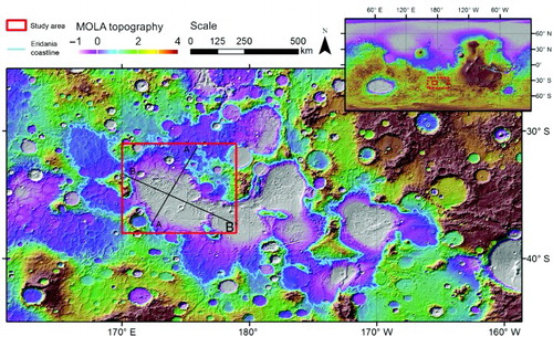
Ma'adim Vallis (), an outflow channel headed in the Ariadnes basin and flowing to the northern plains (Baker et al., Citation1991), originated by the catastrophic overflow of the Eridania paleolake during the Late Noachian (3.71–3.83 Ga) (Irwin et al., Citation2004; Kuzmin, Greeley, Landheim, Cabrol, & Farmer, Citation2000). The distribution and origin of erosional features within and around this paleolake basin suggests that the Eridania system has hosted a temporary body of water which must have existed for enough time to enable formation of the observed features (Cabrol, Grin, Landheim, Kuzmin, & Greeley, Citation1998; Irwin et al., Citation2002; Kuzmin et al., Citation2000). shows the 900 meter (above the Martian datum) contour, the approximate location of the proposed Eridania Lake shoreline (Irwin et al., Citation2002, Citation2004).
Fe/Mg-rich smectite clays and other phyllosillicate deposits have been detected in the knob field outcrops mentioned earlier, in Atlantis Chaos, Gorgonum Chaos and Ariadnes Colles (Adeli et al., Citation2012; Gilmore et al., Citation2011; Molina et al., Citation2012; Wendt, Bishop, & Neukum, Citation2012). Ariadnes basin shows some of the best-preserved outcrops. Smectite clays may be authigenic minerals formed in a standing body of water or by alteration processes. However, they may also be detrital minerals that formed elsewhere and were transported to and deposited in the basin. Additionally, chloride-bearing deposits have been identified in the region (Glotch, Bandfield, Tornabene, Jensen, & Seelos, Citation2010; Osterloo et al., Citation2008; Osterloo, Anderson, Hamilton, & Hynek, Citation2010).
Previous studies provided regional and local maps of the Eridania area (Greeley & Guest, Citation1987; Irwin et al., Citation2002, Citation2004), and more recently some areas have been partially mapped (Baker & Head, Citation2012; Grant et al., Citation2010; Osterloo et al., Citation2010). However, these maps have been produced using images of lower resolution than many currently available, and they do not provide a detailed stratigraphic framework.
As a first step to unveil the geological processes recorded in Ariadnes basin, we have produced a 1:1,000,000 geological map of the western Eridania system (NE of Eridania quadrangle), which extends from 31°S to 38°S and from 170°E to 179°E. It includes the complete Ariadnes basin and part of a minor basin that is situated to the SE of the main Ariadnes basin. In our approach, we aim to determine the stratigraphical relationships between the geological units in order to constrain the evolution of paleoenvironmental and climatic conditions in the Late Noachian/Early Hesperian.
2. Data and methods
2.1. Data
As a cartographic base for our mapping, we used topographic data from two different instruments and high-resolution images and hyperspectral data from three cameras () that were recovered from the NASA's Planetary Data System (PDS, http://pds.jpl.nasa.gov/) and ESA's Planetary Science Archive (PSA, http://www.rssd.esa.int/). Topographic and image datasets were integrated into a Geographic Information System (Esri ArcGIS 10) by conversion and correction of data as described below. We used the Mars 2000 spheroid geographic coordinate system (semi-major axis: 3,396,190.0 m; Semi-minor axis: 3,376,200.0 m; Inverse flattening: 0.0058860) and the equidistant cylindrical projection system with a central meridian at 180°.
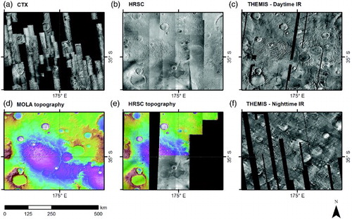
Figure 2. Representation of the different available datasets used in this work. Context Camera (A, CTX) and High Resolution Stereo Camera (B, HRSC) corresponding to the visible imagery. We also used THermal EMision Image System (THEMIS) for infrared imagery, both daytime (C) and nighttime (F), and as topographic information the Mars Orbiter Laser Altimeter (D, MOLA) and HRSC derived (E) data.
2.1.1. Context camera (CTX)
The Context Camera (CTX) is an instrument onboard NASA's Mars Reconnaissance Orbiter (MRO) spacecraft designed to obtain grayscale images of the surface of Mars with a resolution of 5.0 to 6.5 meters per pixel and a swath width of about 30 to 40 kilometers from an altitude of about 290 km (Malin et al., Citation2007). The CTX camera provides the spatial context for other MRO instruments. Since its orbit insertion in 2006, the CTX has obtained images that cover over half of the planet's surface. This extensive coverage in combination with other medium to high-resolution images makes this dataset highly suitable for regional studies.
Available images within the study area (≈58% coverage, ) were downloaded from the PDS. The Integrated Software for Imagers and Spectrometers (ISIS) software (Torson & Becker, Citation1997) distributed by the US Geological Survey (USGS) was used to perform noise removal and radiometric and geometrical corrections as well as map projections, following their recommended procedures (USGS Astrogeology Team, Citation1999).
2.1.2. High-resolution stereo camera (HRSC)
The European Space Agency's (ESA) mission Mars Express (MEx), orbiting Mars since December 2003, is equipped with a High-Resolution Stereo Camera (HRSC) to acquire high-resolution images of the Martian surface in stereo and color. This multi-sensor push broom instrument is composed of nine charge-coupled device (CCD) line detectors mounted in parallel on a focal plane, which allows near-simultaneous high-resolution stereo, multicolor and multi-phase imaging data during a single overpass (Jaumann et al., Citation2007; Neukum, Jaumann, & HRSC Co-Investigator and Experiment Team, 2004). The average spatial resolution of HRSC images is commonly between 10 and 20 meters per pixel at the nominal periapsis altitude of 250 km. The swath width of a typical HRSC image is ∼60 km. The highly elliptical orbit of MEx induces changes in the ground resolution and swath width of the HRSC images; in general the orthoimages are map-projected at resolutions of 12.5 to 25.0 meters per pixel for the panchromatic nadir channel. The sub-pixel accuracy of the three-dimensional point determination allows the derivation of Digital Terrain Models (DTMs) with a typical grid cell size of 50 to 100 m and a height (vertical) accuracy of ∼10 m in each pixel (Jaumann et al., Citation2007; Scholten et al., Citation2005). The total coverage of available images exceeds 90% of the global surface, but the topographic coverage is more limited. Georeferenced and corrected HRSC images and DTMs matching the study area (complete coverage for the images and ≈48% for derived DTMs, ) were obtained from PSA. They were then processed to make them compatible with ArcGIS with the ESA Mars Express HRSC data to GIS converter (HRSC2GIS tool), developed by J. Oosthoek from the Geological Survey of the Netherlands.
2.1.3. Thermal emision imaging system (THEMIS)
THEMIS is a camera on board NASA's 2001 Mars Odyssey orbiter designed to obtain visible/near-infrared and thermal-infrared multi-spectral images in five and nine bands, respectively, where visible/near-infrared wavelengths are centered at 0.42 to 0.86 microns, whereas thermal-infrared wavelengths are centered at 6.8 to 14.9 microns. It acquires day and night multi-spectral infrared images at 100 meters per pixel spatial resolution, and one-band visible images at 18 meters per pixel (Christensen et al., Citation2004). Infrared imagery allows physical surface characteristics to be better distinguished than images taken at visible light wavelengths (Hook, Gabell, Green, & Kealy, Citation1992; Kahle, Gillespie, & Goetz, Citation1976; Watson, Citation1975). THEMIS has an extensive coverage of Mars, which is almost complete in the infrared (≈96% for daytime and ≈82% nighttime coverage, Figure 2).
For this work, we have used two GIS-ready IR mosaics (day and nighttime) available in PSD, with a resolution of 593 pixels per degree (100 meters per pixel).
2.1.4. Mars orbiter laser altimeter (MOLA)
The Mars Orbiter Laser Altimeter (MOLA) is an instrument onboard NASA's Mars Global Surveyor (MGS) mission (Smith et al., Citation2001; Zuber et al., Citation1992). MOLA transmitted infrared laser pulses at a frequency of 10 Hz toward Mars' surface to recover a topographic dataset with a vertical precision of 30 cm, which has been used to generate topographic maps of the whole planet. To create the Ariadnes basin map, we have prepared the dataset in a GIS-ready elevation model of 128 pixels per degree (Mission Experiment Gridded Data Record, MEGDR) (Smith, Neumann, Arvidson, Guinness, & Slavney, Citation2003), which is equivalent to 463 meters per pixel at the Martian equator.
2.2. Geologic mapping
Our geologic mapping of the Ariadnes basin follows the cartographic criteria common in planetary geology based on texture and relief of the planetary surface. We differentiated geologic (material) units and geomorphic features (Hansen, Citation2000; Wilhelms, Citation1990). Geomorphological unit boundaries were determined using a digitizing table and following differential morphological and topological patterns as identified in the image and topographic datasets. The symbolization is based on USGS guidance for planetary geology features (FGDC, Citation2006).
The study area was divided into eight units whose boundaries were differentiated depending on whether the contacts between units were clearly observed or only inferred by geomorphic changes. Such units were mapped following their characterization in previous publications. They were named beginning with one or two capital letters indicating their estimated age (Noachian, Hesperian, Amazonian, or two periods combined in age), followed by one or two lower case letters (initial/s of unit names). This rule is not applied to the impact craters and ejecta unit (cr).
We mapped impact crater rims, using different symbols when they are smaller or larger than 5 km in diameter. Craters smaller than 1 kilometer were not mapped to improve the map clarity, although craters as small as 15 meters were used for crater counts in selected areas. Rimless, buried or degraded craters were identified with a specific symbol different from that used for well-preserved structures. Other structural elements such as tectonic features (e.g. fractures and faults, winkle ridges, and ridge crests) were also assigned characteristic symbols. Ridge crests were identified mainly as linear features with positive topography with a cross-sectional profile that is much sharper than that of winkle ridges. Furthermore, shallow depressions, which are inferred as the geomorphological record of valleys carved by water, were mapped as linear features following the most topographically depressed points of the ‘stream bed’.
The delineation of the knob fields in Ariadnes Colles was performed using a semi-automated boundary detection method. For this purpose, we prepared squares of ≈50 × 50 km HRSC images and exported them to Vextractor software. In this software, a brightness threshold was used after applying a blur effect and image segmentation to differentiate light-toned knob materials from the surroundings. Subsequently, we applied a de-speckle filter and an algorithm to remove the isolated spots, followed by edge detection, vectorization, and export to a shapefile. Finally we revised the knobs one by one, correcting delimitation flaws and combining them in a unified layer. This method is based on the detection of the image edge, and the delimitation corresponds to the knob outcrop and not to the actual elevation of the mounds. Consequently, in this case we give preference to compositional mapping criteria against morphological. MOLA topography does not have sufficient resolution to provide good results for smaller knobs, and HRSC-derived DTMs do not cover the complete extension of the knob field by the time the analysis was performed.
2.3. Age determinations
To understand the geological evolution of the area, we measured the crater size-frequency distribution of the most relevant geological units. The areas were selected by their homogeneous texture and the available coverage by CTX images, which was limited in our study area at the time of writing (). HRSC imagery covering the complete study area was used for regional ages. Craters larger than 5 km were counted for regional ages, and those down to 15 meters were used for selected areas. We used statistical analyses of crater size-frequency distributions to estimate absolute model ages. For mapping and counting of craters, we used the ‘Crater Tool’ ArcGIS extension (Kneissl, van Gasselt, & Neukum, Citation2011). The resulting crater size-frequency curves were analyzed using ‘Craterstats2’ (Michael & Neukum, Citation2010) that has been designed to obtain ages of the affected geological units, based on both the chronology function of Hartmann and Neukum (Citation2001) and the production function of Ivanov (Citation2001). A resurfacing correction was applied to any analysis for obtaining a correct estimation of the model ages (Michael & Neukum, Citation2010).
3. Geologic units and landforms
We defined eight distinct geologic units and several geomorphic landforms including tectonic, impact-related, and erosional features.
The Amazonian Hesperian ridged (AHr) and Noachian cratered plains (Npl) (Greeley & Guest, Citation1987) appear mostly in the topographically lowest and highest areas, respectively. In addition, Npl has a rough and uneven surface, with relict relief, highly cratered areas, and dendritic fluvial valley networks. Crater rims display much younger dense gully systems. Conversely, the AHr unit has flat, smooth, and relatively crater-free surfaces, which usually develop ridges, crests, and winkle ridges and also have a few inverted channels.
The Hesperian Electris deposits (He) occur unevenly at the margins of the basins as a mantling blanket that laterally tapers out, complicating its delimitation. In the S and SW of Ariadnes it usually occurs as high-standing mesas, with steep margins and an upper flat surface, which laterally changes to a thin mantling unit with unclear contacts, covering the bottom of topographic depressions. The He unit also has abundant branched and sinuous channels (exceptional examples of channels are found in the NE and SW areas of Ariadnes), as well as several winkle ridges in the eastern side of the region. He have been interpreted as light-toned volcanic airfall materials with a thickness of 200–500 m and are widespread in the region (Grant & Schultz, Citation1990; Grant et al., Citation2010).
The Hesperian Noachian knob field unit (HNk) appears in the topographically lower parts of the Ariadnes basin and in the unnamed depression in the SE of the study area, but some isolated HNk patches and knobs can be found in AHr. We have identified more than 5000 light-toned knobs, but only 337 are larger than 5 km2. Most of the knobs are located at absolute elevations between − 200 and 500 m relative to the Martian datum and have heights between 50 and 300 m. Their higher elevations follow along the general E – W topographic alignment of the area, matching with the ridge crest systems on Hr. Interestingly, in the Ariadnes' knob field a dark material (same as in AHr and Ap) fills the depressions between the knobs, whereas in the southeast field it disappears and is replaced by a surface characterized by channel-like grooves.
Associated with the AHr unit we also found two different types of deposits with very distinct features. The first one is characterized by a low IR reflectance and high albedo. It forms patches in the North and the East of the study area and fills depressions that are encircled by channels. Such patterns are observed in chloride salt deposits elsewhere on Mars (Osterloo et al., Citation2010), and we define it as Amazonian evaporite deposits (Ae). The second type of deposit has a high IR reflectance, low albedo, and smooth surface, which sharply contrasts with the adjacent HNk and AHr surfaces. Named here as Amazonian plains (Ap), it forms an isolated exposure of 18,192 km2 in the SE of the main knob field at the bottom of the Ariadnes basin. We interpret this as recent lava flows or secondary alteration of unit AHr material.
Impact crater ejecta and smooth crater floors have been defined as two other units. Impact crater ejecta appear as lobate and rampart ejecta blankets, as well as possible pedestal structures (e.g. Carr, Citation2006). When the deposits associated with craters are covering and hiding the material underneath, we classified such surfaces as the impact crater and ejecta unit (cr), including the crater rim and other related surfaces. Several heterogeneous deposits infilling the crater depressions have been defined as the Hesperian Amazonian ‘flat-floor crater infilling’ unit (HAf). It includes slope-derived debris, relocated volcanic airfall, lacustrine sediments, and fan deposits. These materials which cannot be reliably put into a chronological context, due to their limited extension and the difficulty in establishing stratigraphic relations to other materials.
4. Stratigraphy and geologic interpretation
The results of the age determination of the different surfaces units are shown in . When combining these age results and the mapped unit distribution, we are able to provide model ages for each unit and their resurfacing processes. The basement corresponds to the oldest surface, Npl, and is dated to 3.93 (±0.05) Ga, in agreement with the estimates in previous studies that the basement age is Middle Noachian (Greeley & Guest, Citation1987) or Middle Noachian to Early Hesperian (Kuzmin et al., Citation2000).
Figure 3. (Left) Age determination (dots) and error ranges (lines) obtained from different units of the area of study. Horizontal straight lines represent boundaries between the different geologic periods of Mars, whereas dashed lines mark boundaries between epoch (Hartmann & Neukum, Citation2001). (Right) Stratigraphic sequence of Ariadnes inferred from age determinations and spatial relations between units determined in the cartography. At the right, the blue ellipses show the duration of valley networks and the outflow channel activity on Mars (Fassett & Head, Citation2008; Tanaka, Citation1997).
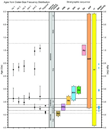
Crater counting results show that the AHr unit age is 3.32 ± 0.17 Ga (obtained from the southern part of Hr), older than previous estimates of an Early Hesperian age (Greeley & Guest, Citation1987; Wendt et al., Citation2013). The He unit has an age of around 3.50 ± 0.20 Ga and should therefore have been deposited shortly before the formation of AHr. It is close to a late Hesperian age as estimated by Grant and Schultz (Citation1990), but we disagree with the age of 3.88 Ga proposed by Wendt et al. (Citation2013).
During the late Hesperian, and close to the transition to the Amazonian period, AHr and Ap units were resurfaced in the North and Northwest of the study area. This activity is likely related to the deposition of the Hesperian Electris material and possibly to associated volcanic events (e.g. Elysium or others; e.g. Werner, Citation2009) that may have produced this airfall deposit. The Electris deposits and the southern surface of AHr were modified by a second resurfacing event at about 2.20 ± 0.25 Ga, which is likely related to a younger fluvial event that eroded the older materials in the area (Ehlmann et al., Citation2011; Fassett & Head, Citation2008). Ap unit seems to correspond to a very thin layer that was produced as the last unit. It shows up as a resurfacing age of AHr at about 1.50 ± 0.15 Ga (age obtained in Ap but also in the South of AHr).
Crater counting of HNk or Ae units was not possible due to their limited extent. However, simple stratigraphical correlations suggest that HNk was deposited between Npl and AHr, since light-toned mounds in the knob fields are covered by AHr, which is interpreted as dark volcanic material. On the other hand, as Ae overlies the AHr and He units, Hd should be younger than both units. Furthermore, the Ae evaporite-like material could have been formed around the Hesperian-Amazonian boundary, which is reported to record a climatic transition to the current hyperarid conditions (Fassett & Head, Citation2008). It would be in agreement with the age constraints proposed by Osterloo et al. (Citation2010) that date the evaporite-rich materials to between the Middle to Late Noachian and the Late Hesperian.
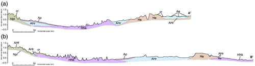
Finally, we provide two tentative geological cross-sections that show a geometric model of how the different units may be related to one other (). The profiles have been constructed by establishing the stratigraphical framework, the geometry of the contacts between units, and the estimation of absolute model ages through crater counting.
Figure 4. Interpretative geological cross-sections (A – A′ and B – B′) showing relations between different units obtained by the contact relationships between units and the ages obtained by crater counting (). Cross-section transects are showed in the location map () as black straight lines.
5. Conclusions
The 1:1,000,000 scale geologic map of the Ariadnes basin, one of the depressions that hosted the Eridania paleolake in Terra Sirenum, has been produced to constrain the geological evolution of the region during the Late Noachian/Early Hesperian periods, although it provides a stratigraphic framework that covers the complete history of the region. It provides unprecedented detail and integrates most available information for the area, mapping eight different units and diverse geomorphic landforms. The analysis of the distinct morphological units provides constraints on the evolution of paleoenvironmental conditions in the Ariadnes region.
Software
The Integrated Software for Imagers and Spectrometers (ISIS) software and ‘isis2world’ script, both developed by USGS, were used to process the data. ArcGIS 10 Desktop was used for mapping and the layout development, with HRSC2GIS extension used for ESA Mars Express HRSC data conversion. The software used for a semi-automatic delineation of knobs was Vextractor. Finally, the ‘CraterTool’ ArcGIS extension (Kneissl et al., Citation2011) and ‘Craterstats2’ software (Michael & Neukum, Citation2010) were used for statistical analysis of crater size-frequency distributions.
Main Map: Geology of the Ariadnes Basin, NE Eridania Quadrangle, Mars - 1:1Million
Download PDF (5.9 MB)Acknowledgements
This work was supported by the Spanish National Research Council (CSIC) under Grant JAE-Predoc; Helmholtz Alliance ‘Planetary Evolution and Life’; and Ministry of Economy and Competitiveness under Grant AYA2009-11681. This research has made use of the USGS Integrated Software for Imagers and Spectrometers (ISIS).
References
- Adeli, S., Le Deit, L., Hauber, E., Molina, A., & Jaumann, R. (2012). Phyllosilicate-rich Knobs in the Atlantis Chaos Basin, Terra Sirenum, Vol. 7 (p. 291). Presented at the European planetary science congress 2012, held 23–28 September, 2012 in Madrid, Spain, id. EPSC2012-291.
- Anderson, R. C., & Dohm, J. M. (2011). Unraveling the complex history of faulting for the Terra Sirenum region; Mars, Vol. 42 (p. 2221). Lunar and planetary institute science conference abstracts, The Woodlands, Texas.
- Anderson, R. C., Dohm, J. M., Robbins, S., Hynek, B., & Andrews-Hanna, J. (2012). Terra Sirenum: Window into pre-tharsis and tharsis phases of mars evolution, Vol. 43 (p. 2803). Lunar and planetary institute science conference abstracts, The Woodlands, Texas.
- Baker, D. M. H., & Head, J. W. (2012). Geology and chronology of the Ma'adim Vallis-Eridania basin region, mars: Implications for the Noachian-Hesperian hydrologic cycle, Vol. 43 (p. 1252). Lunar and planetary institute science conference abstracts, The Woodlands, Texas.
- Baker, V. R., Strom, R. G., Gulick, V. C., Kargel, J. S., Komatsu, G., & Kale, V. S. (1991). Ancient oceans, ice sheets and the hydrological cycle on Mars. Nature, 352(6336), 589–594. doi:10.1038/352589a0 doi: 10.1038/352589a0
- Bibring, J.-P., Langevin, Y., Gendrin, A., Gondet, B., Poulet, F., Berthé, M., … Drossart, P. (2005). Mars surface diversity as revealed by the OMEGA/Mars express observations. Science, 307(5715), 1576–1581. doi:10.1126/science.1108806 doi: 10.1126/science.1108806
- Cabrol, N. A., Grin, E. A., Landheim, R., Kuzmin, R. O., & Greeley, R. (1998). Duration of the Ma'adim Vallis/Gusev crater hydrogeologic system, mars. Icarus, 133(1), 98–108. doi:10.1006/icar.1998.5914 doi: 10.1006/icar.1998.5914
- Carr, M. H. (2006). The surface of mars (Vol. 6). NY: Cambridge University Press.
- Christensen, P. R., Jakosky, B. M., Kieffer, H. H., Malin, M. C., McSween, Jr, H. Y., Nealson, K., … Ravine, M. (2004). The thermal emission imaging system (Themis) for the mars 2001 Odyssey mission. In C. T. Russell (Ed.), 2001 Mars Odyssey (pp. 85–130). Netherlands: Springer.
- De Pablo, M. A., & Fairén, A. G. (2004). Atlantis basin, Sirenum Terrae, Mars: geological setting and astrobiological implications. International Journal of Astrobiology, 3(3), 257–263. doi:10.1017/S147355040400196X doi: 10.1017/S147355040400196X
- Ehlmann, B. L., Mustard, J. F., Murchie, S. L., Bibring, J.-P., Meunier, A., Fraeman, A. A., & Langevin, Y. (2011). Subsurface water and clay mineral formation during the early history of Mars. Nature, 479(7371), 53–60. doi:10.1038/nature10582 doi: 10.1038/nature10582
- Fassett, C. I., & Head III, J. W. (2008). The timing of martian valley network activity: Constraints from buffered crater counting. Icarus, 195(1), 61–89. doi:10.1016/j.icarus.2007.12.009 doi: 10.1016/j.icarus.2007.12.009
- FGDC. (2006). FGDC Digital Cartographic Standard for Geologic Map Symbolization. National Aeronautics and Space Administration (Doctoral dissertation, National Aeronautics and Space Administration).
- Gilmore, M. S., Thompson, D. R., Anderson, L. J., Karamzadeh, N., Mandrake, L., & Castaño, R. (2011). Superpixel segmentation for analysis of hyperspectral data sets, with application to Compact Reconnaissance Imaging Spectrometer for Mars data, Moon Mineralogy Mapper data, and Ariadnes Chaos, Mars. Journal of Geophysical Research: Planets, 116(E7), E07001. doi:10.1029/2010JE003763 doi: 10.1029/2010JE003763
- Glotch, T. D., Bandfield, J. L., Tornabene, L. L., Jensen, H. B., & Seelos, F. P. (2010). Distribution and formation of chlorides and phyllosilicates in Terra Sirenum, Mars. Geophysical Research Letters, 37(16), L16202. doi:10.1029/2010GL044557 doi: 10.1029/2010GL044557
- Grant, J. A., & Schultz, P. H. (1990). Gradational epochs on Mars: Evidence from West-Northwest of Isidis Basin and Electris. Icarus, 84(1), 166–195. doi:10.1016/0019-1035(90)90164-5 doi: 10.1016/0019-1035(90)90164-5
- Grant, J. A., Wilson, S. A., Noe Dobrea, E., Fergason, R. L., Griffes, J. L., Moore, J. M., & Howard, A. D. (2010). HiRISE views enigmatic deposits in the Sirenum Fossae region of Mars. Icarus, 205(1), 53–63. doi:10.1016/j.icarus.2009.04.009 doi: 10.1016/j.icarus.2009.04.009
- Greeley, R., & Guest, J. (1987). Geologic map of the eastern equatorial region of Mars. USGS Numbered Series. M(200) I no.1802-B.
- Hansen, V. L. (2000). Geologic mapping of tectonic planets. Earth and Planetary Science Letters, 176(3–4), 527–542. doi:10.1016/S0012-821X(00)00017-0 doi: 10.1016/S0012-821X(00)00017-0
- Hartmann, W. K., & Neukum, G. (2001). Cratering chronology and the evolution of mars. Space Science Reviews, 96(1–4), 165–194. doi:10.1023/A:1011945222010 doi: 10.1023/A:1011945222010
- Hook, S. J., Gabell, A., Green, A., & Kealy, P. (1992). A comparison of techniques for extracting emissivity information from thermal infrared data for geologic studies. Remote Sensing of Environment, 42(2), 123–135. doi:10.1016/0034-4257(92)90096-3 doi: 10.1016/0034-4257(92)90096-3
- Howard, A. D., & Moore, J. M. (2011). Late Hesperian to early Amazonian midlatitude Martian valleys: Evidence from Newton and Gorgonum basins. Journal of Geophysical Research: Planets, 116(E5), E05003. doi:10.1029/2010JE003782 doi: 10.1029/2010JE003782
- Irwin, R. P., Howard, A. D., & Maxwell, T. A. (2004). Geomorphology of Ma'adim Vallis, Mars, and associated paleolake basins. Journal of Geophysical Research: Planets, 109(E12), E12009. doi:10.1029/2004JE002287 doi: 10.1029/2004JE002287
- Irwin, R. P., Maxwell, T. A., Howard, A. D., Craddock, R. A., & Leverington, D. W. (2002). A large Paleolake basin at the head of Ma'adim Vallis, mars. Science, 296(5576), 2209–2212. doi:10.1126/science.1071143 doi: 10.1126/science.1071143
- Ivanov, B. A. (2001). Mars/Moon cratering rate ratio estimates. Space Science Reviews, 96(1–4), 87–104. doi:10.1023/A:1011941121102 doi: 10.1023/A:1011941121102
- Jaumann, R., Neukum, G., Behnke, T., Duxbury, T. C., Eichentopf, K., Flohrer, J., … Wählisch, M. (2007). The high-resolution stereo camera (HRSC) experiment on mars express: Instrument aspects and experiment conduct from interplanetary cruise through the nominal mission. Planetary and Space Science, 55(7–8), 928–952. doi:10.1016/j.pss.2006.12.003 doi: 10.1016/j.pss.2006.12.003
- Kahle, A. B., Gillespie, A. R., & Goetz, A. F. H. (1976). Thermal inertia imaging: A new geologic mapping tool. Geophysical Research Letters, 3(1), 26–28. doi:10.1029/GL003i001p00026 doi: 10.1029/GL003i001p00026
- Kneissl, T., van Gasselt, S., & Neukum, G. (2011). Map-projection-independent crater size-frequency determination in GIS environments—New software tool for ArcGIS. Planetary and Space Science, 59(11–12), 1243–1254. doi:10.1016/j.pss.2010.03.015 doi: 10.1016/j.pss.2010.03.015
- Kuzmin, R., Greeley, R., Landheim, R., Cabrol, N., & Farmer, J. (2000). Geologic mapping of the Ma'adim Vallis-Gusev crater region of Mars. US. Geol. Surv. Misc. Inv. Ser. MTM, 2256–2257.
- Lucchitta, B. K., Isbell, N. K., & Howington-Kraus, A. (1994). Topography of Valles Marineris: Implications for erosional and structural history. Journal of Geophysical Research: Planets, 99(E2), 3783–3798. doi:10.1029/93JE03095 doi: 10.1029/93JE03095
- Malin, M. C., Bell, J. F., Cantor, B. A., Caplinger, M. A., Calvin, W. M., Clancy, R. T., … Wolff, M. J. (2007). Context camera investigation on board the mars reconnaissance orbiter. Journal of Geophysical Research: Planets, 112(E5), E05S04. doi:10.1029/2006JE002808 doi: 10.1029/2006JE002808
- McEwen, A. S., Eliason, E. M., Bergstrom, J. W., Bridges, N. T., Hansen, C. J., Delamere, W. A., … others. (2007). Special section: Mars reconnaissance orbiter mission and science investigations-E05S02-mars reconnaissance orbiter's high resolution imaging science experiment (HiRISE)(doi:10.1029/2005JE002605). Journal of Geophysical Research-Part E-Planets, 112(5), E05S02.
- Michael, G. G. (2013). Planetary surface dating from crater size–frequency distribution measurements: Multiple resurfacing episodes and differential isochron fitting. Icarus, 226(1), 885–890. doi:10.1016/j.icarus.2013.07.004 doi: 10.1016/j.icarus.2013.07.004
- Michael, G. G., & Neukum, G. (2010). Planetary surface dating from crater size–frequency distribution measurements: Partial resurfacing events and statistical age uncertainty. Earth and Planetary Science Letters, 294(3–4), 223–229. doi:10.1016/j.epsl.2009.12.041 doi: 10.1016/j.epsl.2009.12.041
- Molina, A., Hauber, E., Le Deit, L., Adeli, S., Fernández-Remolar, D. C., & de Pablo, M. A. (2012). Geologic analysis of knob fields and sedimentary deposits in Ariadnes Colles, Terra Sirenum, Mars, Vol. 7 (p. 213). Presented at the European planetary science congress 2012, held 23–28 September, 2012 in Madrid, Spain, id. EPSC2012-213.
- Murchie, S. L., Mustard, J. F., Ehlmann, B. L., Milliken, R. E., Bishop, J. L., McKeown, N. K., … Bibring, J.-P. (2009). A synthesis of Martian aqueous mineralogy after 1 mars year of observations from the mars reconnaissance orbiter. Journal of Geophysical Research: Planets, 114(E2), E00D06. doi:10.1029/2009JE003342
- Neukum, G., Jaumann, R., & HRSC Co-Investigator and Experiment Team. (2004). HRSC: The high resolution stereo camera of Mars Express. European Space Agency, (Special Publication) ESA SP, 1240, 17–35.
- Osterloo, M. M., Anderson, F. S., Hamilton, V. E., & Hynek, B. M. (2010). Geologic context of proposed chloride-bearing materials on Mars. Journal of Geophysical Research: Planets, 115(E10), E10012. doi:10.1029/2010JE003613 doi: 10.1029/2010JE003613
- Osterloo, M. M., Hamilton, V. E., Bandfield, J. L., Glotch, T. D., Baldridge, A. M., Christensen, P. R., … Anderson, F. S. (2008). Chloride-Bearing materials in the Southern highlands of mars. Science, 319(5870), 1651–1654. doi:10.1126/science.1150690 doi: 10.1126/science.1150690
- Phillips, R. J., Zuber, M. T., Solomon, S. C., Golombek, M. P., Jakosky, B. M., Banerdt, W. B., … Ii, S. A. H. (2001). Ancient geodynamics and global-scale hydrology on mars. Science, 291(5513), 2587–2591. doi:10.1126/science.1058701 doi: 10.1126/science.1058701
- Scholten, F., Gwinner, K., Roatsch, T., Matz, K., Giese, B., Oberst, J., … Neukum, G. (2005). Mars express HRSC data processing-methods and operational aspects. Photogrammetric Engineering and Remote Sensing, 71(10), 1143–1152. doi: 10.14358/PERS.71.10.1143
- Schultz, R. A. (1998). Multiple-process origin of Valles Marineris basins and troughs, mars. Planetary and Space Science, 46(6–7), 827–834. doi:10.1016/S0032-0633(98)00030-0 doi: 10.1016/S0032-0633(98)00030-0
- Smith, D., Neumann, G., Arvidson, R., Guinness, E., & Slavney, S. (2003). Mars global surveyor laser altimeter mission experiment gridded data record. MGS-M-MOLA-5-MEGDR-L3-V1. 0. NASA Planetary Data System. http://pds.nasa.gov/ds-view/pds/viewProfile.jsp?dsid=MGS-M-MOLA-5-MEGDR-L3-V1.0
- Smith, D. E., Zuber, M. T., Frey, H. V., Garvin, J. B., Head, J. W., Muhleman, D. O., … Sun, X. (2001). Mars Orbiter Laser Altimeter: Experiment summary after the first year of global mapping of Mars. Journal of Geophysical Research: Planets, 106(E10), 23689–23722. doi:10.1029/2000JE001364 doi: 10.1029/2000JE001364
- Tanaka, K. L. (1997). Sedimentary history and mass flow structures of Chryse and Acidalia Planitiae, Mars. Journal of Geophysical Research: Planets, 102(E2), 4131–4149. doi:10.1029/96JE02862 doi: 10.1029/96JE02862
- Torson, J. M., & Becker, K. J. (1997). ISIS – A software architecture for processing planetary images, Vol. 28 (p. 1443). Lunar and planetary institute science conference abstracts, The Woodlands, Texas.
- USGS Astrogeology Team. (1999). United States Geological Survey Integrated Software for Imaging Spectrometers (ISIS).
- Watson, K. (1975). Geologic applications of thermal infrared images. Proceedings of the IEEE, 63(1), 128–137. doi:10.1109/PROC.1975.9712 doi: 10.1109/PROC.1975.9712
- Wendt, L., Bishop, J. L., & Neukum, G. (2012). Phyllosilcates in the knob fields around Ariadnes Colles on mars: Stratigraphy, mineralogy and morphology. In A. Abbasi & N. Giesen (Eds.), EGU general assembly conference abstracts (Vol. 14, p. 9105). Vienna, Austria.
- Wendt, L., Bishop, J. L., & Neukum, G. (2013). Knob fields in the Terra Cimmeria/Terra Sirenum region of Mars: Stratigraphy, mineralogy and morphology. Icarus, 225(1), 200–215. doi:10.1016/j.icarus.2013.03.020 doi: 10.1016/j.icarus.2013.03.020
- Werner, S. C. (2009). The global martian volcanic evolutionary history. Icarus, 201(1), 44–68. doi:10.1016/j.icarus.2008.12.019 doi: 10.1016/j.icarus.2008.12.019
- Werner, S. C., & Tanaka, K. L. (2011). Redefinition of the crater-density and absolute-age boundaries for the chronostratigraphic system of Mars. Icarus, 215(2), 603–607. doi:10.1016/j.icarus.2011.07.024 doi: 10.1016/j.icarus.2011.07.024
- Wilhelms, D. E. (1990). Geologic mapping. In R. Greeley & R. M. Batson (Eds.), Planetary mapping (pp. 208–260). NY: Cambridge University Press.
- Wilson, L., & Head, J. W. (2002). Tharsis-radial graben systems as the surface manifestation of plume-related dike intrusion complexes: Models and implications. Journal of Geophysical Research: Planets, 107(E8), 1–1–1–24. doi:10.1029/2001JE001593
- Zuber, M. T., Smith, D. E., Solomon, S. C., Muhleman, D. O., Head, J. W., Garvin, J. B., … Bufton, J. L. (1992). The mars observer laser altimeter investigation. Journal of Geophysical Research: Planets, 97(E5), 7781–7797. doi:10.1029/92JE00341 doi: 10.1029/92JE00341