
Abstract
The Ischia Island, located in the north-western zone of Napoli bay (Southern Italy), is exposed to many natural events that represent sources of risk for both the tourists visiting the island all over the year and the local inhabitants. In this paper, we take advantage of spatial and temporal analysis available in a Geographic Information System framework in order to compare the spatial distribution of volcanic hazard zones to the temporal evolution of population and urban development over the last 80 years. The volcanic hazard map refers to pyroclastic flows from low to intermediate size explosive events, that could affect the Ischia Island in the next future. The main result of the study centered on the finding that the territorial system development was not sensitive to volcanic hazard as testified by the expansion of urbanized areas within the medium-high hazard zones. The seriousness of the present territorial system status indicates an urgent need for planning aimed at a proper cohabitation of the inhabitants with the hazardous events and at the achievement of acceptable safeness levels.
The map presented here gives a synoptic view of the territorial system evolution related to volcanic hazard and it can therefore be considered a valuable tool to support a sustainable territorial planning. The urban development data can be suitably used to assess their relationship with other natural events which could affect the island.
1. Introduction
Natural events become dangerous when they affect a densely populated area; only in these populated zones, in fact, can they pose hazards and turn into disasters directly affecting human populations. In some cases this is a consequence of spatial planning policies that did not take into account the possible occurrence of natural events or the extent to which the population would be affected (CitationAlberico et al., 2012). During the last decade, the idea that the impact of hazardous events can be reduced through some technical interventions has been coupled with the necessity to form disaster resilient communities by promoting an enhanced awareness of disaster reduction as an integral component of sustainable development (CitationISDR, 2004). In as much, the best knowledge of the areas devastated by natural events in the past used in combination with disaster forecasting methods is fundamental for the authority in charge of territorial management to mitigate or even eliminate adverse impacts on the territorial system.
The entire territory of Ischia Island (Southern Italy) is shared by six municipalities applying diverse strategies to manage the environmental and tourist resources. This status combined with the exposure to natural hazards (including seismic, volcanic, gravitational, coastal erosion and marine inundation events), makes the Ischia island a good test area for urban space planning. Starting from the pioneering work of CitationPetrosino et al. (2004) at Campi Flegrei and Somma-Vesuvio, the present paper investigates the urban development at Ischia Island over the last 80 years, in terms of inhabited areas expansion and population increase, to verify if and how much the urban evolution is sensitive to the possible occurrence of volcanic events. Diffuse thermal springs and fumarolic activity, in fact, are evidence that Ischia Island is an active volcanic field and scientific community expects eruptive activity to resume in the next future. In this framework, we focused our attention on the comparison of hazard zoning, the urban extent, and population trends associated with cross-sectional years of 1936, 1957, 1984 and 2004 (also examined across the entire period in longitudinal form). The intersection of single urbanized areas with the volcanic hazard zoning for the entire island made it possible to identify hazard classes where the urban settlements varied, both in partial intervals and along the entire investigated period. The progressive comparison of urbanized extent among the above cited intervals led us to detect the urban evolution trend at municipality scale. At the same time, and by examining population data from 1951 to 2010 (CitationISTAT, 2012), we were able to track the trends of residents at the same scale. Finally, we highlighted the key role of an integrated knowledge of both social and physical features in association with a specific territory for stimulating a future planning aimed at improving resilience and preparation in face of natural hazards within a policy of sustainable urban development.
2. Study area
The Ischia Island, located in the north-western zone of Napoli bay (Southern Italy) has an area of about 42 km2. There are several main landforms () that consist of mostly well-preserved monogenetic volcanoes and Monte Epomeo that, with its 800 m height, is the highest peak of the island. It is the emerged top of a large volcanic apparatus characterized by block resurgence in its middle part (CitationAcocella and Funiciello, 1999; CitationAcocella, Funiciello, Marotta, Orsi, & De Vita, 2004; CitationCarlino, 2012; CitationGillot, Chiesa, Pasquare, & Vezzoli, 1982; CitationRittmann, 1930; CitationVezzoli, 1988, CitationOrsi, Gallo, & Zanchi, 1991). Ischia is still an active volcanic area, as evidenced by the occurrence of eruptions in historical times (CitationRittmann, 1930; CitationVezzoli, 1988), widespread fumaroles and thermal springs (CitationChiodini et al., 2004; CitationInguaggiato, Pecoraino, & D'Amore, 2000), and seismic activity (e.g. the 1883 Casamicciola earthquake; CitationCubellis, Carlino, Iannuzzi, Luongo, & Obrizzo, 2004; CitationJohnston-Lavis, 1885).
Figure 1. Geological sketch map of Ischia Island (CitationOrsi et al., 2003, modified). Location of the study area in the inset.
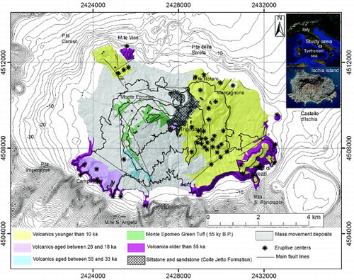
Volcanism at Ischia began prior to 150 ka, the age of remnants of the oldest products cropping out in the south-eastern part of the island. The volcanic history of the island was dominated by the Green Tuff eruption (ca. 55 ka; CitationVezzoli, 1988) that caused the collapse of the central part of the island (55 ka — CitationPoli, Chiesa, Gillot, Gregnanin, & Guichard, 1987), giving way to marine sedimentation (sequence of tuffite, sandstone and siltstone) and followed, starting from 30 ka, by resurgence of the Monte Epomeo block (CitationAcocella and Funiciello, 1999; CitationOrsi et al., 1991). Three phases of volcanism younger than Green Tuff were recognized, in the 50–33, 28–18 and 10 ka to Present time spans (CitationChiesa, Civetta, De Lucia, Orsi, & Poli, 1987). The last period of activity encompassed both magmatic and hydromagmatic monogenetic eruptions with vents mainly located in the eastern part of the island.
3. Volcanic hazard and urban evolution
3.1. Fundamentals
The hazard factor is the only parameter of the risk formula (Risk= Hazard × Vulnerability × Value- CitationFournier d'Albe, 1979; CitationUNESCO, 1972) that cannot be modified in order to reduce the risk because it only relies to the occurrence of natural events. The value and the vulnerability, respectively defined as the number of lives or the monetary value of goods at risk and the percentage of lives or goods likely to be lost because of a given event, are the two parameters of the formula modifiable to reduce the risk. Urban expansion in hazardous areas must take into account the potential damage source, and territorial planners must act as a consequence. Since the Ischia Island territorial plan devoted to mitigate and reduce the natural risk is in its very beginning phases (CitationProvincial Territorial Plan of Napoli, 2009; CitationRegional Territorial Plan of Campania Region, 2006), an up-dated and global knowledge of the present condition of the urban development of the island is urgent. Aiming at achieving it, we investigated the relationship between urban fabric and population trend of the six municipalities of Ischia Island in the last 80 years, by using the algorithms of spatial analysis available in the ArcGis® software.
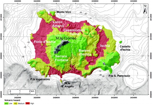
Recently, as far as volcanic hazard assessment is concerned, replace in Citationde Vita, Sansivero, Orsi, Marotta, & Piochi (2010), through the reconstruction of activity in the past 10 ka, highlighted that the eruptive events were mainly concentrated at ca. 5.5 ka and that the youngest span the last 2.9 ka with variable recurrence. No relationship links the duration of quiescence periods to the features and size of eruptions. Only the volcanic hazard maps for pyroclastic flow events with Volcanic Explosivity Index (VEI) 3 and 4 are available so far (CitationAlberico, Lirer, Petrosino, & Scandone, 2008).
4. Methods
The volcanic hazard map published by CitationAlberico et al. (2008) is the sum of two different information, the Vent Opening Probability (VOP) and the spatial frequency of invasion of pyroclastic flows (PyF).
The site of occurrence of a possible future eruption at Ischia Island is hard to evaluate in a probabilistic way by using statistical procedures, since the vent locations of ancient eruptions are often obliterated by the deposits of landslides and recent eruptions. As a consequence, the VOP was assessed by parceling the territory into 0.5 km side square cells and quantifying the contribution of geological (faults, fumaroles, hydrothermal sources location), geophysical (earthquake location, Bouguer anomalies) and geo-chemical (radon emission) indicators to define the areas with different probability of volcanic activity renewal.
These data were successively joined with the frequency of invasion by PyF, defined by using the ‘energy cone’ model (CitationMalin and Sheridan, 1982), for VEI=3 and VEI=4 eruptions. The sources of the simulated events were centered in all the square cells previously used to quantify VOP. The overlay of the energy cone to the digital elevation model made it possible to automatically detect the invaded areas for each hypothesized vent. Through the intersection of these areas, the different spatial probabilities of invasion by pyroclastic flows for each point of the territory were defined ().
Figure 2. Volcanic hazard map of Ischia Island (CitationAlberico et al., 2008, modified).
Input data used for the urban development analysis derive from the historical maps of Italian Military Geographic Institute (IGMI) of 1936, 1957, 1984 at 1:25.000 scale and the technical maps of Campania Region of 2004 at 1:5.000 scale. The urban areas expansion data are acquired through two simple steps: (a) georeferencing of the maps, (b) digitalization of the urban areas.
The technical maps of Campania Region (projection UTM – zone 33 north, datum ED50) were used as a basis to geo-reference the historical maps, because, with respect to the other available maps, they ensure the maximum accuracy thanks to the highest resolution at the largest scale. At this aim a series of ground control points, linking a precise site in the historical maps with the same site in the technical maps of Campania Region, was identified.
In order to investigate the growth of the urban settlements, we started to digitize the urbanized areas from the historical map of 1936, and progressively added the same information reported in more recent maps (). Through this approach the urbanized areas of 1936 were inherited and expanded including further areas urbanized in the following years. The extent of the urbanized areas in the four maps (IGMI of 1936, 1957, 1984 and technical maps of 2004) for the six municipalities of Ischia Island is reported in . Furthermore, the incremental value of urban areas in the different time spans was evaluated for the single municipalities ((a)) and the entire island ((b)) and expressed as a percentage of total urban area in the bar plots of .
Figure 3. Urban development at Ischia Island from 1936 to 2004.
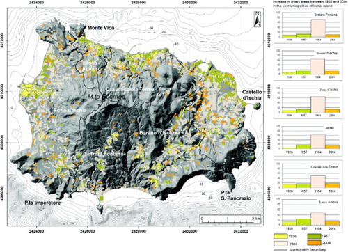
Figure 4. Rate of increase of urban area extent in the single municipalities (a) and in the entire Ischia Island (b) from 1936 to 2004. Municipality labels: B=Barano d'Ischia, C=Casamicciola Terme, F=Forio d'Ischia, I= Ischia, L=Lacco Ameno, S= Serrara Fontana.
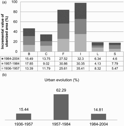
Table 1. Extent in square kilometers of the urbanized areas in 1936, 1957, 1984 and 2004 for the six municipalities of Ischia Island.
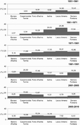
In addition the demographic analysis was carried out starting from 1951 on the data of the National Institute for Statistics, available for decadal intervals until 2001 and for five-year intervals up to 2010 (CitationISTAT, 2012). The analysis of the total population data of the six Ischia municipalities allowed us to define the population development across the temporal intervals (). The rate of decadal population growth as a percentage of the population in 2010 was also calculated for the single municipality ().
Figure 5. Population trend in the six municipalities of Ischia Island from 1951 to 2010.
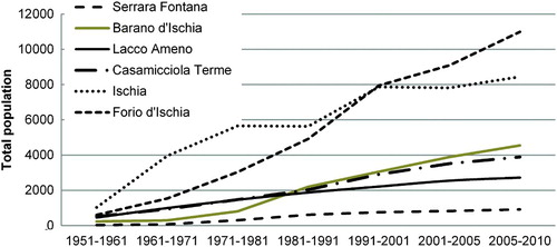
Figure 6. Rate of total population growth in the six municipalities of Ischia Island from 1951 to 2010.
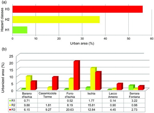
Finally, in order to quantify the relationship between territorial and natural processes, we intersected urban extent and volcanic hazard classes (Main Map). The extent of urban areas pertaining to the three hazard classes was depicted for the 1936–2004 interval ((a,b)) and through the incremental value in three different time spans: 1936–1957, 1957–1984, 1984–2004 (bar plots in the Main Map) for the single municipality.
Figure 7. Percentage of urban extent in different hazard areas for the whole island territory (a) and for the single municipality (b) between 1936 and 2004.
5. Results
The analysis of the urban development carried out for the purposes of the present paper points out that the expansion of urbanized areas from 1936 to 1957 ranged between 5% of the total population increase at Serrara Fontana and 35% at Ischia, whereas from 1957 to 1984 it ranged between 4% at Lacco Ameno and 30% at Ischia and Forio. Between 1957 and 2004, the minimum increase was recorded at Serrara Fontana (5%) and the maximum (32%) at Ischia ( and (a)). The mean urban area increase for the entire island peaked between 1957 and 1984, reaching a value around 60% ((b)).
From the analysis of the resident population in the 1951–2010 period (CitationISTAT, 2012 – ) the highest increase of residents occurred in Forio d'Ischia and Ischia. The number of inhabitants at Casamicciola, Lacco Ameno and Barano d'Ischia municipalities increased slightly less, while Serrara Fontana followed a decidedly smaller trend of growth. In addition, the rates of population growth showed that along the last 80 years the population increase was not homogeneous in all the municipalities but that, on the whole, population grew in the entire island. The highest number of residents at the end of the sixties was recorded at Lacco Ameno (increase by 26%) and Ischia (increase by 20%), followed by Forio d'Ischia and Serrara Fontana (increase by ca. 10%). With the only exception of the Seventies, when the population increase was comparable for all municipalities (15%–18%, except Forio d'Ischia -5%), in the following years Ischia, Forio d'Ischia and Casamicciola Terme recorded a higher growth ().
The results of the intersection between hazard classification and urban expansion data (Main Map) made it possible to evaluate, for each municipality, the degree of urban expansion during the last century that involved high hazard areas, or had been restricted to the areas less exposed to the possible emplacement of volcanic products. High hazard zones mostly coincide with flat areas where the emplacement of pyroclastic flows is more probable (). The same areas, in contrast, are the most favorable for the enlargement of urban settlements. As a consequence, in the last 80 years the urban areas expanded toward the medium and high volcanic hazard areas ((a)). The highest expansion was first recorded in the municipalities where flat morphologies prevail (Ischia, Forio d'Ischia – (b)). Only recently have municipalities such as Serrara Fontana, which is mainly characterized by rugged areas, recorded a meaningful urban expansion along the southern slopes of Monte Epomeo (Main Map). A general view on the hazard potential of new urban settlements lets to figure out that, irrespective of the possible occurrence of a new eruption, through all the analyzed periods urban expansion mainly involved high and medium hazard zones in all municipalities.
6. Conclusions
The spatial and temporal analysis of urbanized areas and population data indicate that inhabitants increased significantly across the 80-year examination period, but the rates varied in the different investigated temporal intervals. Forio d'Ischia and Ischia ultimately proved to be the municipalities with the highest residents number followed by Barano d'Ischia, Casamicciola Terme and Lacco Ameno. The number of inhabitants, however, is a minimum estimate because during the summer the arrival of tourists triples the number of people living in the island. Also, since 1980 urbanization has widely expanded in the areas where hazard of building collapses due to pyroclastic flow propagation is the highest, i.e. the flat zones separating the remnants of monogenetic volcanoes and the foot-slopes of Monte Epomeo (Main Map).
The main conclusion of our investigation is that in the last century the territorial system of the island was not sensitive to the impending volcanic risk. The Main Map provides a valid tool to compile a priority list of the built zones that need structural measures to minimize the adverse impact of future explosive eruptions. Being that Ischia Island is exposed to many other natural hazards (seismic, volcanic, gravitational, coastal erosion and marine inundation events), a multi-hazard approach would better focus the global exposure of the area. However, our analysis proves that, even taking into account only one of the potential hazards, the need for promoting decision making processes devoted to the reduction in the number of exposed residents and improving risk perception is currently a matter of utmost urgency. Furthermore, by highlighting the possible consequences of inadequate and often unmanaged urban expansion recorded in the last 80 years at Ischia, our work can be a basic tool for communication with stakeholders. The knowledge of the status of impending vulnerability of the territorial system is a first, but important, step toward the achievement of a resilient community, aiming at coping with dangerous conditions caused by natural events.
Main Map: Volcanic Hazard and Territorial Evolution at Ischia Island (Southern Italy) From 1936 to 2004
Download PDF (55.8 MB)Acknowledgements
The authors wish to acknowledge Alessandro Bonforte, Nakos Byron, Vincenzo Di Fiore, Jan-Christoph Otto, Christos Chalkias, Isaak Parcharidis and an anonymous reviewer whose suggestions greatly improved the manuscript. Dr. Stamatis Kalogirou is gratefully acknowledged for inviting us to participate to the Special Issue of JoM.
Software
The georeferencing of historical maps and the digitalization of urban areas was performed using ArcGIS® 9.3. Furthermore, the procedure used to define the volcanic hazard map of Ischia Island was implemented by using the algorithms of spatial analysis available in the same software.
References
- Acocella, V., & Funiciello, R. (1999). The interaction between regional and local tectonics during resurgent doming: the case of the Island of Ischia, Italy. Journal of Volcanology and Geothermal Research, 88, 109–123. doi: 10.1016/S0377-0273(98)00109-7
- Acocella, V., Funiciello, R., Marotta, E., Orsi, G., & De Vita, S. (2004). The role of extensional structures on experimental calderas and resurgence. Journal of Volcanology and Geothermal Research, 129, 199–217. doi: 10.1016/S0377-0273(03)00240-3
- Alberico, I., Lirer, L., Petrosino, P., & Scandone, R. (2008). Volcanic hazard and risk assessment from pyroclastic flows at Ischia island (Southern Italy). Journal of Volcanology and Geothermal Research, 171, 118–136. doi: 10.1016/j.jvolgeores.2007.11.014
- Alberico, I., Petrosino, P., Maglione, G., Bruno, L., Capaldo, F. S., Dal Piaz, A., Lirer, L., & Mazzola, S. (2012). Mapping the vulnerability for evacuation of the Campi Flegrei territorial system in case of a volcanic unrest. Natural Hazards, 64, 1823–1854. doi: 10.1007/s11069-012-0335-x
- Carlino, S. (2012). The process of resurgence for Ischia Island (southern Italy) since 55 ka: the laccolith model and implications for eruption forecasting. Bulletin of Volcanolology, 74, 947–961. doi: 10.1007/s00445-012-0578-0
- Chiesa, S., Civetta, L., De Lucia, M., Orsi, G., & Poli, S. (1987). Volcanological evolution of the Island of Ischia. Rendiconti dell' Accademia di Scienze Fisiche Matematiche e Naturali Special Issue, 0, 69–83.
- Chiodini, G., Avino, R., Brombach, T., Caliro, S., Cardellini, C., de Vita, S., Frondini, F., Granirei, D., Marotta, E., & Ventura, G. (2004). Fumarolic and diffuse soil degassing west of Mount Epomeo, Ischia, Italy. Journal of Volcanology and Geothermal Research, 133, 291–309. doi: 10.1016/S0377-0273(03)00403-7
- Cubellis, E., Carlino, S., Iannuzzi, R., Luongo, G., & Obrizzo, F. (2004). Management of historical seismic data using GIS: the island of Ischia (southern Italy). Natural Hazards, 33, 379–393. doi: 10.1023/B:NHAZ.0000048465.40413.17
- Fournier D'Albe, E. M. (1979). Objective of volcanic monitoring and prediction. Journal of the Geological Society of London, 136, 321–326. doi: 10.1144/gsjgs.136.3.0321
- Gillot, P. Y., Chiesa, S., Pasquarè, G., & Vezzoli, L. (1982). 33, 000 yr K/Ar dating of the volcano tectonic horst of the Island of Ischia, Gulf of Naples. Nature, 229, 243–245.
- Inguaggiato, S., Pecoraino, G., & D'Amore, F. (2000). Chemical and isotopical characterisation of fluid manifestations of Ischia Island (Italy). Journal of Volcanology and Geothermal Research, 99, 151–178. doi: 10.1016/S0377-0273(00)00158-X
- ISDR. (2004). Living with Risk. A global review of disaster reduction initiatives. Retrieved July 8, 2012, from http://www.unisdr.org/we/inform/publications/657
- ISTAT. (2012). National Institute for Statistics. Retrieved October 10, 2012, from http://www.istat.it/
- Johnston-Lavis, H. J. (1885). Monograph of the Earthquakes of Ischia. F. Furchheim (ed.), Naples; Dulau & Co. (eds.), London, 1–122.
- Malin, M. C., & Sheridan, M. F. (1982). Computer-assisted mapping of pyroclastic surges. Science, 217, 637–640. doi: 10.1126/science.217.4560.637
- Orsi, G., Gallo, G., & Zanchi, A. (1991). Simple shearing block-resurgence in caldera depression. A model from Pantelleria and Ischia. Journal of Volcanology and Geothermal Research, 47, 1–11. doi: 10.1016/0377-0273(91)90097-J
- Orsi, G., de Vita, S., Di Vito, M., Isaia, R., Nave, R., & Heiken, G. (2003). Facing volcanic and related hazards in the Neapolitan area. In G. Heiken, R. Fakundiny, & J. Sutter (eds.), Earth sciences in the city (pp. 121–170). Washington: American Geophysical Union (Special Publication).
- Petrosino, P., Alberico, I., Caiazzo, S., Dal Piaz, S., Lirer, L., & Scandone, R. (2004). Volcanic risk and evolution of the territorial system in the active volcanic areas of Naples. Acta Vulcanologica, 16, 163–178.
- Poli, S., Chiesa, S., Gillot, P. Y., Gregnanin, A., & Guichard, F. (1987). Chemistry versus time in the volcanic complex of Ischia (Gulf of Naples, Italy): evidence of successive magmatic cycles. Contribution to Mineralogy and Petrology, 95, 322–335. doi: 10.1007/BF00371846
- Provincial Territorial Plan of Napoli. (2009). Retrieved September 2, 2012, from http://www.provincia.napoli.it/ptcp/
- Regional Territorial Plan of Campania Region. (2006). Retrieved September 2, 2012, from http://www.sito.regione.campania.it/PTR2006/PTRindex.htm
- Rittmann, A. (1930). Geologie der Insel Ischia. Berlin: Ergbn VI für Vulk, 1–265.
- UNESCO. (1972). Report of consultative meeting of experts on the statistical study of natural hazards and their consequences. Document SC/WS/500, 1–11.
- Vezzoli, L. (1988). Island of Ischia. CNR Quaderni della Ricerca Scientifica, 114, 1–133.
- de Vita, S., Sansivero, F., Orsi, G., Marotta, E., & Piochi, M. (2010). Volcanological and structural evolution of the island of Ischia (Italy) over the past 10 ka. In Groppelli, G., & Viereck-Goette, L. (eds.), Stratigraphy and geology of volcanic areas. Geological Society of America, Special Paper, 464, 193–241.