
Abstract
Rapidly flowing ice streams dominate the drainage of continental ice sheets and are a key component of their mass balance. Due to their potential impact on sea level, their activity in the Antarctic and Greenland Ice Sheets has undergone detailed scrutiny in recent decades. However, these observations only cover a fraction of their ‘life-span’ and the subglacial processes that facilitate their rapid flow are very difficult to observe. To circumvent these problems, numerous workers have highlighted the potential of investigating palaeo-ice streams tracks, preserved in the landform and sedimentary record of former ice sheets. As such, it is becoming increasingly important to know where and when palaeo-ice streams operated. In this paper, we present a new map of ice streams in the North American Laurentide Ice Sheet (LIS; including the Innuitian Ice Sheet), which was the largest of the ephemeral Pleistocene ice sheets and where numerous ice streams have been identified. We compile previously published evidence of ice stream activity and complement it with new mapping to generate the most complete and consistent mapping inventory to date. The map depicts close to three times as many ice streams (117 in total) compared to previous inventories, and categorises them according to the evidence they left behind, with some locations more speculative than others. The map considerably refines our understanding of LIS dynamics, but there is a clear requirement for improved dating of ice stream activity.
1. Introduction
Ice flow in the Antarctic and Greenland ice sheets is organised into a spatial pattern of ice streams draining ice from the interior toward the margin and into the ocean (Bentley, Citation1987; Rignot, Mouginot, & Scheuchl, Citation2011). The same spatial organisation of flow toward the ice margin has been suggested for the Pleistocene ice sheets of the northern hemisphere (Denton & Hughes, Citation1981; Hughes, Denton, & Grosswald, Citation1977; Kleman & Glasser, Citation2007; Stokes & Clark, Citation2001) and robust evidence for ice stream activity has been recognised in the glacial landform and sedimentary record (Clark & Stokes, Citation2003; Dyke & Morris, Citation1988; Patterson, Citation1998; Sharpe, Citation1988; Stokes & Clark, Citation2001). The largest ice sheet to grow and disappear was the North American Laurentide Ice Sheet (LIS; ) for which numerous palaeo-ice streams have been hypothesised (see reviews in Patterson, Citation1998; Stokes & Clark, Citation2001; Winsborrow, Clark, & Stokes, Citation2004). Here, we present a new and updated map of palaeo-ice streams in the LIS (including the Innuitian Ice Sheet), building on earlier syntheses (Patterson, Citation1998; Winsborrow et al., Citation2004) and updated to include more recent publications and new mapping at the ice sheet scale.
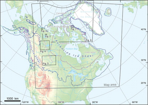
Figure 1. Location map. Outline of the map sheet is indicated in grey and locations of are indicated by black rectangles. Ice sheet extent (Dyke, Moore, & Robertson, Citation2003) is shown for 18 14C ka (21.4 ka BP) in dark blue and for 9 14C ka (10.2 ka BP) in purple.
2. A brief review of previous work
Recognition of the importance of ice streams in the LIS was outlined by Hughes et al. (Citation1977) and Denton and Hughes (Citation1981), who depicted a number of ice streams, based mainly on topographic inferences. Dyke (Citation1984), Dyke and Morris (Citation1988) and Sharpe (Citation1988) were among the first to directly link elements of the glacial landform and sedimentary record with fast ice flow and Dyke and Prest (Citation1987a, Citation1987b) included ice streams in their seminal publications describing the Late Wisconsinan and Holocene history of the LIS based on topographic and sedimentary evidence. Subsequently, Patterson (Citation1997, Citation1998) compiled a map of known ice streams, and she argued that the lobate southern margin of the LIS was produced by ice streams. These were referred to as terrestrial (i.e. land-terminating) ice streams, which do not have any modern analogues. Moreover, the development of geomorphological criteria to identify palaeo-ice streams (Kleman & Borgström, Citation1996; Stokes & Clark, Citation1999) has led to a major growth in the number of hypothesised ice streams (De Angelis & Kleman, Citation2005, 2007; Ross, Campbell, Parent, & Adams, Citation2009; Ross, Lajeunesse, & Kosar, Citation2011; Shaw et al., Citation2006; Stokes, Clark, & Storrar, Citation2009). Winsborrow et al. (Citation2004) also provided an inventory and supporting evidence for each of the hypothesised ice streams within the LIS. More recently, new remote sensing products and digital elevation models have permitted the glacial landform mapping at a regional and ice sheet scale (Atkinson, Utting, & Pawley, Citation2014; Brown, Stokes, & O'Cofaigh, Citation2011; De Angelis, Citation2007a; Shaw, Sharpe, & Harris, Citation2010; Storrar & Stokes, Citation2007; Trommelen & Ross, Citation2010), augmenting the Glacial Map of Canada (Prest, Grant, & Rampton, Citation1968).
Evidence of Laurentide ice stream dynamics has also been found in the ocean sedimentary record in the form of layers of ice-rafted debris (Heinrich layers; Heinrich, Citation1988). These have been interpreted to record major collapses of the ice sheet (in which ice streaming appears prominent) with inferred effects on the global climate system (Andrews, Citation1998; Bond et al., Citation1992; Heinrich, Citation1988; Rashid & Piper, Citation2007; Rashid, Saint-Ange, Barber, Smith, & Devalia, Citation2012). The growth in the identification of ice streams has been mirrored by attempts to test and refine numerical models of their activity in the LIS (Kaplan, Pfeffer, Sassolas, & Miller, Citation1999; Marshall & Clarke, Citation1997; Marshall, Clarke, Dyke, & Fisher, Citation1996; Pfeffer et al., Citation1997; Stokes & Tarasov, Citation2010; Tarasov & Peltier, Citation2004; Winguth, Mickelson, Colgan, & Laabs, Citation2004).
3. Methods
We define ice streams as discrete arteries of enhanced ice flow bordered by slower moving ice (after Swithinbank, Citation1954, rephrased). Initially, we collated published literature hypothesising ice stream activity. Ice streams reported in literature were checked and mapped and, in some cases, their outlines and tracks were re-mapped from recent satellite and digital elevation imagery that might not have been available to the original authors (see below). This also ensured homogeneity of the mapped ice streams. A small number of ice streams inferred from types of evidence other than that visible in remotely sensed and digital elevation data were adopted without major modification. In addition, areas that had not been previously systematically mapped for ice streams have been surveyed using remotely sensed-data to ensure completeness in the mapping. This has resulted in the identification of several newly hypothesised ice streams (cited as new mapping on the main map).
A variety of data were used to distinguish ice stream tracks in the glacial landform record and these are listed in . The northern portion of the mapped area has been surveyed using a false colour composite Landsat image mosaic (, ). Satellite imagery was less useful along the southern and southwestern LIS margin due to the dominance of the agricultural land. Instead, medium to high-resolution digital elevation models (DEMs, , ) were used to map this area. The International Bathymetric Chart of the Arctic Ocean DEM (, ) was used for areas north of the 60th parallel, whereas the continental shelf south of 60° N was mapped from General Bathymetric Chart of the Oceans data (). High-resolution swath bathymetry has been utilised where available (, ).
Figure 2. An example of a full bedform imprint from the Haldane Ice Stream (see for location). Panel (a) depicts a large portion of the ice stream track of the Haldane Ice Stream with an onset zone and lateral margins indicated by white arrows. Note the convergent flow pattern and a gradient in bedform attenuation from the ice stream margin toward the centre of the ice stream. (b) Detail of a lateral margin (see panel (a) for location). Lateral shear moraine is identifiable as a lighter-coloured band in the centre of the panel. Ice flow direction is from lower right to upper left in both panels.
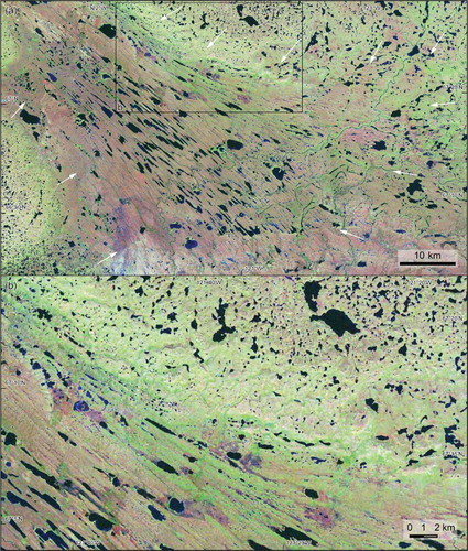
Figure 3. An example of a discontinuous bedform imprint from the downstream portion of the Anderson Ice Stream (see for location). Well-developed streamlining (lower centre) gradually peters out toward the lateral margins and the downstream portion of the Anderson Ice Stream. Bedform directions are indicated by white arrows and approximate limit of a streamlined terrain is indicated by a dashed white line.
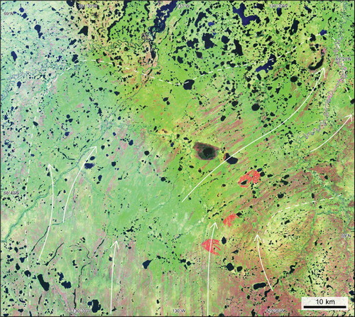
Figure 4. An example of an isolated bedform imprint of the Great Slave Lake Ice Stream. (a) Broad troughs in the north-central portion of the Interior Plains (see for location) seen in a DEM-derived image draped with the Landsat Image Mosaic of Canada. The trough floors are largely devoid of a continuous pattern of glacial lineations. However, isolated patches of extremely well-developed mega-scale glacial lineations occur both on the trough floors – see panel (b), and on the slopes and upper surfaces of the intervening plateaux. Although the glacial troughs define an ice stream configuration in the area (panel c), streamlined terrain on the plateau surfaces (mapped as ice stream fragments) indicates a stage of fast ice flow that was not controlled by topography.
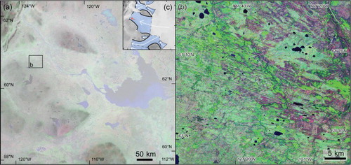
Figure 5. Southern portion of the Interior Plains seen in a mosaic of Canadian Digital Elevation Data tiles (see for location). Displaying hypsography separately for each tile enhances topography in areas with low relief. Networks of ice stream tracks, represented by corridors of smooth topography as well as isolated areas of streamlined terrain can be seen in the data. Lateral margins are drawn by a dotted line (where distinguished) and centre-lines of the ice stream tracks are drawn by full lines.
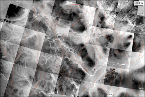
Figure 6. (a) The Canadian Arctic seen in IBCAO topographic data (see for location). Ice streams inferred from wide-scale topography are indicated. Notice the prominent shelf-crossing troughs, overdeepening of some of the channel and fjord floors, as well as sediment bulges (sedimentary depo-centres) built on the edge of the continental shelf. In the case of Nansen Sound (black rectangle), the cross-shelf trough is marked by extensive ridges. See panel (b) for a detail view.
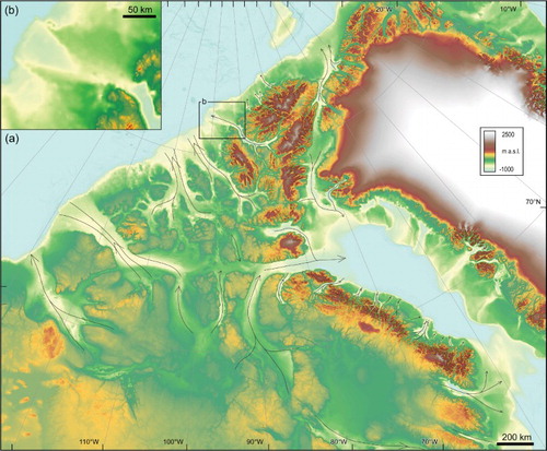
Figure 7. Eclipse Sound at the north coast of Baffin Island (see for location) – a deep sound that forms at a junction of numerous fjords. (a) a DEM-derived image draped with the Landsat Image Mosaic of Canada complemented by high-resolution swath bathymetry data that display well-developed mega-scale glacial lineations on the floor of the sound. See panel (b) for a detail of the onset zone of the streamlined terrain.
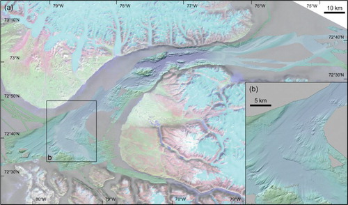
Table 1. Data used for the mapping from the landform record.
Ice streams have been mapped based on several types of evidence, which we formally categorise and show on the map. These include the bedform imprint ( and ), topographic constraints (, , and ) and major sedimentary depo-centres (; Batchelor and Dowdeswell, Citation2013). Other types of evidence include the sedimentary characteristics of subglacial tills or ice rafted debris traced to its sediment sources. Ice streams inferred from their bedform imprint (after (King, Hindmarsh, & Stokes, Citation2009; Kleman et al., Citation2006; Stokes, Citation2002; Stokes & Clark, Citation1999, Citation2001, 2002) have been further categorised into three classes: (i) ice streams with a full bedform imprint (, , and ), (ii) ice streams with discontinuous bedform imprint ( and ) and, (iii) ice streams with only an isolated bedform imprint (). In addition to these an extra class of ice stream fragment has been introduced where isolated evidence of fast ice flow occurs but no inferences can be made about the outline of the zone of fast ice flow ( and ). Ice stream margins, and in some cases ice streams per se, have been defined by broad-scale topography, i.e. by the limits (and the existence of) glacial troughs (, , and ). Where distinct topography was missing, ice stream margins were either recognised as an edge of the bedform imprint (in some cases constituted by a lateral shear margin moraine; see and (Stokes & Clark, Citation2002) or drawn as undefined (). Multiple types of evidence have been found for some ice streams ( and ) whereas other mapped ice streams are only based on one type of evidence ( and ). The strength of the evidence therefore varies and while some ice streams are documented by a robust record, the existence of others is more speculative.
Although our map represents the most complete to date, it is important to acknowledge that some ice streams may have operated, but their evidence has not been preserved. This may be especially true for short-lived ice streams flowing over resistant bedrock (Punkari, Citation1995; Roberts, Long, Davies, Simpson, & Schnabel, Citation2010).
4. Mapping results
The map contains 117 ice streams, which is almost three times more than previous inventories. These vary in size and shape, with some draining large portions of the ice sheet and others being rather minor features, typically draining ice through high-relief coastal areas. Note that we make no inferences on the timing of ice stream operation because very few of the mapped ice streams have any chronological control. However, it is clear that the mapped ice stream tracks represent a time-transgressive imprint of evolving ice stream trajectories, i.e. they cannot have all operated at once. Nevertheless, some broad spatial patterns emerge.
The northernmost part of the LIS covering the Canadian Arctic Archipelago and including the Innuitian Ice Sheet () was drained by a network of ice streams occupying the channels dividing the archipelago's islands and peninsulas. The location and pattern of these ice streams share characteristics with the Siple Coast ice streams of the West Antarctic Ice Sheet (Bennett, Citation2003; De Angelis, Citation2007b; Hughes, Citation1977). The northwestern, western and southwestern margin of the LIS displayed a more complex pattern of sinuous, sometimes cross-cutting, flow trajectories over a relatively flat bed that likely came into operation during different periods of ice sheet growth and decay. Moreover, these were predominantly land-terminating (terrestrial) ice streams. Large terrestrial ice streams also occupied the basins of the Great Lakes at the southern margin of the ice sheet. Further east, the continental shelf fringing the northeastern USA, Atlantic Canada and Labrador hosted a number of ice streams draining into the Atlantic Ocean. Ice streams have also been identified in areas that were close to the centre of a fully grown LIS. These ice streams presumably operated successively during deglaciation when the ice margin gradually retreated into the areas of the main domes in Keewatin, Labrador and Foxe Basin ().
5. Conclusions
A map depicting palaeo-ice streams of the LIS has been produced using previously published hypotheses of their activity, together with new mapping from satellite imagery and digital elevation models, both onshore and offshore. In total, 117 ice streams have been identified, based on a variety of evidence and with some comparatively robust and others more speculative. The map only indicates the spatial distribution of ice streams within the LIS, without providing constraints on their timing of operation. Based on our review of the evidence (see list of sources on the main map), it is likely that the majority relate to the Late Wisconsinan, but we cannot rule out the possibility that some evidence has been preserved from pre-Late Wisconsinan ice sheets. Dating of these palaeo-ice streams is an obvious task for future research. This map, combined with better dating of ice stream operation, will allow for an improved understanding of LIS dynamics and its links to the atmosphere-ocean system. Such reconstructions will also extend the temporal record of ice stream activity, which is currently biased toward short-term observations of modern-day ice sheets.
Software
The mapping was carried out using Esri ArcGIS 10.1. The GEBCO data () were exported for use with ArcGIS using the GDA Software Interface provided with the data. The Google Maps platform was used for displaying the high-resolution swath bathymetry data (). The final layout of the map was produced in Adobe Illustrator CS4.
Supplemental data
Two shapefiles of LIS ice streams are enclosed: one with simplified polygons defining ice stream tracks and the other with polylines depicting lateral margins and ice flow directions. Supplemental data for this article can be accessed here. [10.1080/17445647.2014.912036]
Main Map: Ice Streams in the Laurentide Ice Sheet: A New Mapping Inventory
Download Zip (27.6 MB)Acknowledgments
We thank John Abraham, Nigel Atkinson and Art Dyke for their constructive and insightful comments on the earlier version of the manuscript. We are also grateful to a large number of our colleagues who have helped point us to ice stream literature and landscapes that deserve a closer look, especially those who scrutinised a draft of the map at the Canadian Quaternary Association Biannual Meeting in Edmonton, August 2013.
Funding
This work was supported by the Natural Environment Research Council under grant number NE/J00782X/1.
Related Research Data
References
- Andrews, J. T. (1998). Abrupt changes (Heinrich events) in late Quaternary North Atlantic marine environments: A history and review of data and concepts. Journal of Quaternary Science, 13(1), 3–16. doi: 10.1002/(SICI)1099-1417(199801/02)13:1<3::AID-JQS361>3.0.CO;2-0
- Andrews, J. T., & Barber, D. C. (2002). Dansgaard–Oeschger events: Is there a signal off the Hudson Strait Ice Stream?. Quaternary Science Reviews, 21(1–3), 443–454. doi: 10.1016/S0277-3791(01)00073-7
- Andrews, J. T., & MacLean, B. (2003). Hudson Strait ice streams: A review of stratigraphy, chronology and links with North Atlantic Heinrich events. Boreas, 32(1), 4–17. doi: 10.1080/03009480310001010
- Andrews, J. T., MacLean, B., Kerwin, M., Manley, W., Jennings, A. E., & Hall, F. (1995). Final stages in the collapse of the Laurentide Ice Sheet, Hudson Strait, Canada, NWT: C-14 AMS dates, seismic stratigraphy, and magnetic susceptibility logs. Quaternary Science Reviews, 14(10), 983–1004. doi: 10.1016/0277-3791(95)00059-3
- Andrews, J. T., & Tedesco, K. (1992). Detrital carbonate-rich sediments, northwestern Labrador Sea: Implications for Ice-Sheet dynamics and iceberg rafting (Heinrich) events in the North Atlantic. Geology, 20(12), 1087–1090, 1087. doi: 10.1130/0091-7613(1992)020<1087:dcrsnl>2.3.co;2
- Atkinson, N. (2003). Late Wisconsinan glaciation of Amund and Ellef Ringnes islands, Nunavut: Evidence for the configuration, dynamics, and deglacial chronology of the northwest sector of the Innuitian Ice Sheet. Canadian Journal of Earth Sciences, 40(3), 351–363. doi: 10.1139/e02-106
- Atkinson, N., Utting, D. J., & Pawley, S. M. (Cartographers). (2014). Glacial landforms of Alberta. [Map].
- Batchelor, C. L., & Dowdeswell, J. A. (2013). The physiography of high Arctic cross-shelf troughs. Quaternary Science Reviews, in press. doi: 10.1016/j.quascirev.2013.05.025
- Batchelor, C. L., Dowdeswell, J. A., & Pietras, J. T. (2013a). Seismic stratigraphy, sedimentary architecture and palaeo-glaciology of the Mackenzie Trough: Evidence for two Quaternary ice advances and limited fan development on the western Canadian Beaufort Sea margin. Quaternary Science Reviews, 65, 73–87. doi: 10.1016/j.quascirev.2013.01.021
- Batchelor, C. L., Dowdeswell, J. A., & Pietras, J. T. (2013b). Variable history of Quaternary ice-sheet advance across the Beaufort Sea margin, Arctic Ocean. Geology, 41(2), 131–134. doi: 10.1130/g33669.1
- Batchelor, C. L., Dowdeswell, J. A., & Pietras, J. T. (in press). Evidence for multiple Quaternary ice advances and fan development from the Amundsen Gulf cross-shelf trough and slope, Canadian Beaufort Sea margin. Marine and Petroleum Geology, in press. doi: http://dx.doi.org/10.1016/j.marpetgeo.2013.11.005
- Bednarski, J. M. (1998). Quaternary history of Axel Heiberg Island bordering Nansen Sound, Northwest Territories, emphasizing the last glacial maximum. Canadian Journal of Earth Sciences, 35(5), 520–533. doi: 10.1139/e97-124
- Beget, J. E. (1986). Modeling the influence of till rheology on the flow and profile of the Lake Michigan lobe, southern Laurentide ice sheet, USA. Journal of Glaciology, 32, 235–241.
- Bennett, M. R. (2003). Ice streams as the arteries of an ice sheet: Their mechanics, stability and significance. Earth-Science Reviews, 61(3–4), 309–339. doi: 10.1016/s0012-8252(02)00130-7
- Bentley, C. R. (1987). Antarctic Ice Streams – A review. Journal of Geophysical Research-Solid Earth and Planets, 92(B9), 8843–8858. doi: 10.1029/Jb092ib09p08843
- Blake, J., Weston, Jackson, H. R., & Currie, C. G. (1996). Seafloor evidence for glaciation, northernmost Baffin Bay. Bulletin of the Geological Society of Denmark, 23, 157–168.
- Bond, G., Heinrich, H., Broecker, W., Labeyrie, L., McManus, J., Andrews, J., … Ivy, S. (1992). Evidence for massive discharges of icebergs into the North Atlantic ocean during the last glacial period. Nature, 390(6401), 245–249. doi: 10.1038/360245a0
- Breemer, C. W., Clark, P. U., & Haggerty, R. (2002). Modeling the subglacial hydrology of the late Pleistocene Lake Michigan Lobe, Laurentide Ice Sheet. Geological Society of America Bulletin, 114(6), 665–674. doi: 10.1130/0016-7606(2002)114<0665:mtshot>2.0.co;2
- Briner, J. P. (2007). Supporting evidence from the New York drumlin field that elongate subglacial bedforms indicate fast ice flow. Boreas, 36(2), 143–147. doi: 10.1080/03009480600923394
- Briner, J. P., Miller, G. H., Davis, P. T., & Finkel, R. C. (2006). Cosmogenic radionuclides from fiord landscapes support differential erosion by overriding ice sheets. Geological Society of America Bulletin, 118(3–4), 406–420. doi: 10.1130/b25716.1
- Brookes, I. A. (2007). First recognition of a Laurentide Ice Stream : Robert Bell on Hudson Strait. Géographie physique et Quaternaire, 61(2–3), 211–216. doi: 10.7202/038993ar
- Brown, V. H. (2012). Ice stream dynamics and pro-glacial lake evolution along the north-western margin of the Laurentide Ice Sheet (Unpublished doctoral dissertation). Durham University. Durham. Retrieved from http://etheses.dur.ac.uk/5917/
- Brown, V. H., Stokes, C. R., & O'Cofaigh, C. (2011). The glacial geomorphology of the North-West sector of the Laurentide Ice Sheet. Journal of Maps, 7(1), 409–428. doi: 10.4113/jom.2011.1224
- Brown, V. H., Stokes, C. R., Ó Cofaigh, C., Margold, M., & Clark, C. D. (in prep.). Late Wisconsinan ice stream dynamics at the north-westernmost margin of the Laurentide Ice Sheet.
- Carlson, A. E., Jenson, J. W., & Clark, P. U. (2007). Modeling the subglacial hydrology of the James Lobe of the Laurentide Ice Sheet. Quaternary Science Reviews, 26(9–10), 1384–1397. doi: 10.1016/j.quascirev.2007.02.002
- Clark, C. D., Knight, J. K., & Gray, J. T. (2000). Geomorphological reconstruction of the Labrador Sector of the Laurentide Ice Sheet. Quaternary Science Reviews, 19(13), 1343–1366. doi: 10.1016/S0277-3791(99)00098-0
- Clark, C. D., & Stokes, C. R. (2001). Extent and basal characteristics of the M'Clintock Channel Ice Stream. Quaternary International, 86(1), 81–101. doi: 10.1016/S1040-6182(01)00052-0
- Clark, C. D., & Stokes, C. R. (2003). Palaeo-ice stream landsystem. In D. J. A. Evans (Ed.), Glacial Landsystems (pp. 204–227). London: Arnold.
- Clark, P. (1985). A note on the glacial geology and postglacial emergence of the Lake Harbour region, Baffin Island, N.W.T. Canadian Journal of Earth Sciences, 22(12), 1864–1871. doi: 10.1139/e85-197
- Clark, P. U. (1992). Surface form of the southern Laurentide ice-sheet and its implications to Ice-Sheet dynamics. Geological Society of America Bulletin, 104(5), 595–605. 595. doi: 10.1130/0016-7606(1992)104<0595:sfotsl>2.3.co;2
- Clayton, L., Teller, J. T., & Attig, J. W. (1985). Surging of the southwestern part of the Laurentide Ice Sheet. Boreas, 14(3), 235–241. doi: 10.1111/j.1502-3885.1985.tb00726.x
- Colgan, P. M. (1999). Reconstruction of the Green Bay Lobe, Wisconsin, United States from 26,000 to 13,000 radiocarbon years BP. In D. M. Mickelson & J. W. Attig (Eds.), Glacial processes past and present (Vol. 337, pp. 137–150). Boulder, CO: Geological Society of America.
- De Angelis, H. (2007a). Glacial geomorphology of the east-central Canadian Arctic. Journal of Maps, 3(1), 323–341. doi: 10.1080/jom.2007.9710848
- De Angelis, H. (2007b). Palaeo-ice streams in the north-eastern Laurentide Ice Sheet (Doctoral dissertation). Stockholm University, Stockholm. Retrieved from http://su.diva-portal.org/smash/record.jsf?pid=diva2:197678
- De Angelis, H., & Kleman, J. (2005). Palaeo-ice streams in the northern Keewatin sector of the Laurentide ice sheet. Annals of Glaciology, 42(42), 135–144. doi: 10.3189/172756405781812925
- De Angelis, H., & Kleman, J. (2007). Palaeo-ice streams in the Foxe/Baffin sector of the Laurentide Ice Sheet. Quaternary Science Reviews, 26(9–10), 1313–1331. doi: 10.1016/j.quascirev.2007.02.010
- De Angelis, H., & Kleman, J. (2008). Palaeo-ice-stream onsets: Examples from the north-eastern Laurentide Ice Sheet. Earth Surface Processes and Landforms, 33(4), 560–572. doi: 10.1002/esp.1663
- Denton, G. H., & Hughes, T. (1981). The Last Great Ice Sheets. New York: Wiley-Interscience.
- Dowdeswell, J. A., Maslin, M. A., Andrews, J. T., & McCave, I. N. (1995). Iceberg production, debris rafting, and the extent and thickness of Heinrich layers (H-1, H-2) in North Atlantic sediments. Geology, 23(4), 301–304. doi: 10.1130/0091-7613(1995)023<0297:ipdrat>2.3.co;2
- Dredge, L. A. (2000). Carbonate dispersal trains, secondary till plumes, and ice streams in the west Foxe Sector, Laurentide Ice Sheet. Boreas, 29(2), 144–156. doi: 10.1111/j.1502–3885.2000.tb01207.x
- Dredge, L. A. (2001). Late Pleistocene and Holocene glaciation and deglaciation of Melville Peninsula, Northern Laurentide Ice Sheet. Géographie physique et Quaternaire, 55(2), 159. doi: 10.7202/008300ar
- Dredge, L. A., & Cowan, W. R. (1989), 159–170. Quaternary geology of the southwestern Canadian Shield. In R. J. Fulton (Ed.), Quaternary geology of Canada and Greenland (pp. 214–235). Ottawa: Geological Survey of Canada.
- Dyke, A. S. (1984). Quaternary geology of Boothia Peninsula and northern District of Keewatin, central Canadian Arctic. Geological Survey of Canada Memoir 407. Ottawa: Energy, Mines and Resources Canada.
- Dyke, A. S. (1999). Last glacial maximum and deglaciation of devon island, arctic canada: Support for an innuitian Ice Sheet. Quaternary Science Reviews, 18(3), 393–420. doi: 10.1016/S0277-3791(98)00005-5
- Dyke, A. S. (2008). The Steensby Inlet Ice Stream in the context of the deglaciation of Northern Baffin Island, Eastern Arctic Canada. Earth Surface Processes and Landforms, 33(4), 573–592. doi: 10.1002/esp.1664
- Dyke, A. S., & Dredge, L. A. (1989). Quaternary geology of the northwestern Canadian Shield. In R. J. Fulton (Ed.), Quaternary geology of Canada and Greenland (Vol. 3, pp. 189–214). Ottawa: Geological Survey of Canada.
- Dyke, A. S., Dredge, L. A., & Vincent, J.-S. (1982). Configuration and dynamics of the Laurentide Ice Sheet during the Late Wisconsin maximum. Géographie physique et Quaternaire, 36(1–2), 5–14. doi: 10.7202/032467ar
- Dyke, A. S., Moore, A., & Robertson, L. (2003). Deglaciation of North America. Ottawa: Geological Survey of Canada.
- Dyke, A. S., & Morris, T. F. (1988). Canadian landform examples 0.7. Drumlin fields, dispersal trains, and Ice Streams in Arctic Canada. The Canadian Geographer / Le Géographe canadien, 32(1), 86–90. doi: 10.1111/j.1541-0064.1988.tb00860.x
- Dyke, A. S., Morris, T. F., Green, D. E. C., & England, J. (1992). Quaternary Geology of Prince of Wales Island, Arctic Canada. Geological Survey of Canada Memoir 433.
- Dyke, A. S., & Prest, V. K. (1987a). Late Wisconsinan and Holocene history of the Laurentide Ice Sheet. Géographie physique et Quaternaire, 41(2), 237–263. doi: 10.7202/032681ar
- Dyke, A. S., & Prest, V. K. (Cartographers). (1987b). Paleogeography of northern North America, 18 000 – 5000 years ago. [Map].
- England, J. (1999). Coalescent Greenland and Innuitian ice during the Last Glacial Maximum: Revising the Quaternary of the Canadian High Arctic. Quaternary Science Reviews, 18(3), 421–456. doi: 10.1016/S0277-3791(98)00070-5
- England, J., Atkinson, N., Bednarski, J., Dyke, A. S., Hodgson, D. A., & Ó Cofaigh, C. (2006). The Innuitian Ice Sheet: Configuration, dynamics and chronology. Quaternary Science Reviews, 25(7–8), 689–703. doi: 10.1016/j.quascirev.2005.08.007
- England, J. H., Atkinson, N., Dyke, A. S., Evans, D. J. A., & Zreda, M. (2004). Late Wisconsinan buildup and wastage of the Innuitian Ice Sheet across southern Ellesmere Island, Nunavut. Canadian Journal of Earth Sciences, 41(1), 39–61. doi: 10.1139/e03-082
- England, J. H., Furze, M. F. A., & Doupé, J. P. (2009). Revision of the NW Laurentide Ice Sheet: Implications for paleoclimate, the northeast extremity of Beringia, and Arctic Ocean sedimentation. Quaternary Science Reviews, 28(17–18), 1573–1596. doi: 10.1016/j.quascirev.2009.04.006
- Evans, D. J. A. (2000). Quaternary geology and geomorphology of the Dinosaur Provincial Park area and surrounding plains, Alberta, Canada: The identification of former glacial lobes, drainage diversions and meltwater flood tracks. Quaternary Science Reviews, 19(10), 931–958. doi: 10.1016/S0277-3791(99)00029-3
- Evans, D. J. A., Clark, C. D., & Rea, B. R. (2008). Landform and sediment imprints of fast glacier flow in the southwest Laurentide Ice Sheet. Journal of Quaternary Science, 23(3), 249–272. doi: 10.1002/jqs.1141
- Evans, D. J. A., Hiemstra, J. F., Boston, C. M., Leighton, I., Ó Cofaigh, C., & Rea, B. R. (2012). Till stratigraphy and sedimentology at the margins of terrestrially terminating ice streams: Case study of the western Canadian prairies and high plains. Quaternary Science Reviews, 46, 80–125. doi: 10.1016/j.quascirev.2012.04.028
- Evans, D. J. A., Young, N. J. P., & Ó Cofaigh, C. (2014). Glacial geomorphology of terrestrial-terminating fast flow lobes/ice stream margins in the southwest Laurentide Ice Sheet. Geomorphology, 204, 86–113. doi: 10.1016/j.geomorph.2013.07.031
- Eyles, N. (2012). Rock drumlins and megaflutes of the Niagara Escarpment, Ontario, Canada: A hard bed landform assemblage cut by the Saginaw–Huron Ice Stream. Quaternary Science Reviews, 55, 34–49. doi: 10.1016/j.quascirev.2012.09.001
- Eyles, N., & Putkinen, N. (2014). Glacially-megalineated limestone terrain of Anticosti Island, Gulf of St. Lawrence, Canada; onset zone of the Laurentian Channel Ice Stream. Quaternary Science Reviews, 88(0), 125–134. doi: http://dx.doi.org/10.1016/j.quascirev.2014.01.015
- Grant, D. R. (1989). Quaternary geology of the Atlantic Appalachian region of Canada. In R. J. Fulton (Ed.), Quaternary geology of Canada and Greenland (pp. 391–440). Ottawa: Geological Survey of Canada.
- Greenwood, S. L., & Kleman, J. (2010). Glacial landforms of extreme size in the Keewatin sector of the Laurentide Ice Sheet. Quaternary Science Reviews, 29(15–16), 1894–1910. doi: 10.1016/j.quascirev.2010.04.010
- Heinrich, H. (1988). Origin and consequences of cyclic ice rafting in the Northeast Atlantic Ocean during the past 130000 years. Quaternary Research, 29(2), 142–152. doi: 10.1016/0033-5894(88)90057-9
- Hicock, S. R. (1988). Calcareous till facies North of Lake Superior, Ontario: Implications for Laurentide Ice Streaming. Géographie physique et Quaternaire, 42(2), 120–135. doi: 10.7202/032719ar
- Hicock, S. R. (1992). Lobal interactions and rheologic superposition in subglacial till near Bradtville, Ontario, Canada. Boreas, 21(1), 73–88. doi: 10.1111/j.1502-3885.1992.tb00014.x
- Hicock, S. R., & Dreimanis, A. (1992). Deformation till in the Great Lakes region: Implications for rapid flow along the south-central margin of the Laurentide Ice Sheet. Canadian Journal of Earth Sciences, 29(7), 1565–1579. doi: 10.1139/e92-123
- Hicock, S. R., Kristjansson, F. J., & Sharpe, D. R. (1989). Carbonate till as a soft bed for Pleistocene ice streams on the Canadian Shield north of Lake Superior. Canadian Journal of Earth Sciences, 26(11), 2249–2254. doi: 10.1139/e89-191
- Hiscott, R. N., Aksu, A. E., Mudie, P. J., & Parsons, D. F. (2001). A 340,000 year record of ice rafting, palaeoclimatic fluctuations, and shelf-crossing glacial advances in the southwestern Labrador Sea. Global and Planetary Change, 28(1–4), 227–240. doi: 10.1016/S0921-8181(00)00075-8
- Hodgson, D. A. (1994). Episodic Ice Streams and ice shelves during retreat of the northwesternmost sector of the late Wisconsinan Laurentide Ice Sheet over the central Canadian Arctic Archipelago. Boreas, 23(1), 14–28. doi: 10.1111/j.1502-3885.1994.tb00582.x
- Hooyer, T. S., & Iverson, N. R. (2002). Flow mechanism of the Des Moines lobe of the Laurentide Ice Sheet. Journal of Glaciology, 48(163), 575–586. doi: 10.3189/172756502781831160
- Hughes, T. (1977). West Antarctic Ice Streams. Reviews of Geophysics, 15(1), 1–46. doi: 10.1029/RG015i001p00001
- Hughes, T., Denton, G. H., & Grosswald, M. G. (1977). Was there a Late-Wurm Arctic Ice Sheet. Nature, 266(5603), 596–602. doi: 10.1038/266596a0
- Jakobsson, M., Andreassen, K., Bjarnadóttir, L. R., Dove, D., Dowdeswell, J. A., England, J. H., … Stein, R. (in press). Arctic Ocean glacial history. Quaternary Science Reviews. doi: 10.1016/j.quascirev.2013.07.033
- Jakobsson, M., Cherkis, N., Woodward, J., Macnab, R., & Coakley, B. (2000). New grid of Arctic bathymetry aids scientists and mapmakers. EOS, Transactions American Geophysical Union, 81(9), 89–96. doi: 10.1029/00EO00059
- Jansson, K., Stroeven, A., & Kleman, J. (2003). Configuration and timing of Ungava Bay ice streams, Labrador-Ungava, Canada. Boreas, 32(1), 256–262. doi: 10.1080/03009480310001146
- Jennings, A. E. (1993). The Quaternary history of Cumberland Sound, Southeastern Baffin Island: The Marine evidence. Géographie physique et Quaternaire, 47(1), 21–42. doi: 10.7202/032929ar
- Jennings, A. E., Tedesco, K. A., Andrews, J. T., & Kirby, M. E. (1996). Shelf erosion and glacial ice proximity in the Labrador Sea during and after Heinrich events (H-3 or 4 to H-0) as shown by foraminifera. Geological Society, London, Special Publications, 111(1), 29–49. doi: 10.1144/gsl.sp.1996.111.01.04
- Jennings, C. E. (2006). Terrestrial ice streams – A view from the lobe. Geomorphology, 75(1–2), 100–124. doi: 10.1016/j.geomorph.2005.05.016
- Josenhans, H. W., & Zevenhuizen, J. (1989). Quaternary geology II, Labrador Sea, surficial geology and physical properties. In J. S. Bell, R. D. Howie, N. J. McMillan, C. M. Hawkins, & J. L. Bates (Eds.), East coast Basin Atlas Series (pp. 10–11). Ottawa: Geological Survey of Canada.
- Josenhans, H. W., & Zevenhuizen, J. (1990). Dynamics of the Laurentide Ice Sheet in Hudson Bay, Canada. Marine Geology, 92(1), 1–26. doi: 10.1016/0025-3227(90)90024-E
- Kaplan, M. R., Miller, G. H., & Steig, E. J. (2001). Low-gradient outlet glaciers (ice streams?) drained the Laurentide Ice Sheet. Geology, 29(4), 343–346. doi: 10.1130/0091-7613(2001)029<0343:lgogis>2.0.co;2
- Kaplan, M. R., Pfeffer, W. T., Sassolas, C., & Miller, G. H. (1999). Numerical modelling of the Laurentide Ice Sheet in the Baffin Island region: The role of a Cumberland Sound Ice Stream. Canadian Journal of Earth Sciences, 36(8), 1315–1326. doi: 10.1139/cjes-36-8-1315
- Karrow, P. F. (1989). Quaternary geology of the Great Lakes subregion. In R. J. Fulton (Ed.), Quaternary geology of Canada and Greenland (pp. 326–350). Ottawa: Geological Survey of Canada.
- Kehew, A. E., Beukema, S. P., Bird, B. C., & Kozlowski, A. L. (2005). Fast flow of the Lake Michigan Lobe: Evidence from sediment-landform assemblages in southwestern Michigan, USA. Quaternary Science Reviews, 24(22), 2335–2353. doi: 10.1016/j.quascirev.2005.01.017
- Kehew, A. E., Esch, J. M., Kozlowski, A. L., & Ewald, S. K. (2012). Glacial landsystems and dynamics of the Saginaw Lobe of the Laurentide Ice Sheet, Michigan, USA. Quaternary International, 260, 21–31. doi: 10.1016/j.quaint.2011.07.021
- Keigwin, L. D., & Jones, G. A. (1995). The marine record of deglaciation from the continental margin off Nova Scotia. Paleoceanography, 10(6), 973–985. doi: 10.1029/95PA02643
- King, E. C., Hindmarsh, R. C. A., & Stokes, C. R. (2009). Formation of mega-scale glacial lineations observed beneath a West Antarctic ice stream. Nature Geoscience, 2(8), 585–588. doi: 10.1038/Ngeo581
- Kirby, M. E. (1998). Heinrich event-0 (DC-0) in sediment cores from the northwest Labrador Sea: Recording events in Cumberland Sound? Canadian Journal of Earth Sciences, 35(5), 510–519. doi: 10.1139/e97-119
- Kleman, J., & Borgström, I. (1996). Reconstruction of palaeo-ice sheets: The use of geomorphological data. Earth Surface Processes and Landforms, 21(10), 893–909. doi: 10.1002/(SICI)1096-9837(199610)21:10<893::AID-ESP620>3.0.CO;2-U
- Kleman, J., & Glasser, N. (2007). The subglacial thermal organisation (STO) of ice sheets. Quaternary Science Reviews, 26(5–6), 585–597. doi: 10.1016/j.quascirev.2006.12.010
- Kleman, J., Hättestrand, C., Stroeven, A. P., Jansson, K. N., De Angelis, H., & Borgström, I. (2006). Reconstruction of Palaeo-Ice Sheets-Inversion of their Glacial Geomorphological Record. In P. G. Knight (Ed.), Glacier science and environmental change (pp. 192–198). Oxford: Blackwell.
- Lakeman, T. R., & England, J. H. (2012). Paleoglaciological insights from the age and morphology of the Jesse moraine belt, western Canadian Arctic. Quaternary Science Reviews, 47, 82–100. doi: 10.1016/j.quascirev.2012.04.018
- Lamoureux, S. F., & England, J. H. (2000). Late Wisconsinan glaciation of the central sector of the Canadian High Arctic. Quaternary Research, 54(2), 182–188. doi: 10.1006/qres.2000.2167
- Laymon, C. A. (1992). Glacial geology of western Hudson Strait, Canada, with reference to Laurentide Ice Sheet dynamics. Geological Society of America Bulletin, 104(9), 1169–1177. doi: 10.1130/0016-7606(1992)104<1169:ggowhs>2.3.co;2
- Lemmen, D. S., Duk-Rodkin, A., & Bednarski, J. M. (1994). Late glacial drainage systems along the northwestern margin of the Laurentide Ice Sheet. Quaternary Science Reviews, 13(9–10), 805–828. doi: 10.1016/0277-3791(94)90003-5
- Li, G., Piper, D. J. W., & Calvin Campbell, D. (2011). The Quaternary Lancaster Sound trough-mouth fan, NW Baffin Bay. Journal of Quaternary Science, 26(5), 511–522. doi: 10.1002/jqs.1479
- Lian, O., Hicock, S., & Dreimanis, A. (2003). Laurentide and Cordilleran fast ice flow: Some sedimentological evidence from Wisconsinan subglacial till and its substrate. Boreas, 32(1), 102–113. doi: 10.1080/03009480310001056
- Løken, O. H., & Hodgson, D. (1971). On the submarine geomorphology along the east coast of Baffin Island. Canadian Journal of Earth Sciences, 8(2), 185–195. doi: 10.1139/e71-020
- Lusardi, B. A., Jennings, C. E., & Harris, K. L. (2011). Provenance of Des Moines lobe till records ice-stream catchment evolution during Laurentide deglaciation. Boreas, 40(4), 585–597. doi: 10.1111/j.1502-3885.2011.00208.x
- MacLean, B., Blasco, S., Bennett, R., England, J., Rainey, W., Hughes-Clarke, J., & Beaudoin, J. (2010). Ice keel seabed features in marine channels of the central Canadian Arctic Archipelago: Evidence for former ice-steams and iceberg scouring. Quaternary Science Reviews, 29(17–18), 2280–2301. doi: 10.1016/j.quascirev.2010.05.032
- Manley, W. F. (1996). Late-glacial flow patterns, deglaciation, and postglacial emergence of south-central Baffin Island and the north-central coast of Hudson Strait, eastern Canadian Arctic. Canadian Journal of Earth Sciences, 33(11), 1499–1510.
- Marshall, S. J., & Clarke, G. K. C. (1997). A continuum mixture model of Ice Stream thermomechanics in the Laurentide Ice Sheet 0.2. Application to the Hudson Strait ice stream. Journal of Geophysical Research-Solid Earth, 102(B9), 20615–20637. doi: 10.1029/97jb01189
- Marshall, S. J., Clarke, G. K. C., Dyke, A. S., & Fisher, D. A. (1996). Geologic and topographic controls on fast flow in the Laurentide and Cordilleran Ice Sheets. Journal of Geophysical Research-Solid Earth, 101(B8), 17827–17839. doi: 10.1029/96jb01180
- Mathews, W. H. (1991). Ice sheets and ice streams: Thoughts on the Cordilleran Ice Sheet Symposium. Géographie physique et Quaternaire, 45(3), 263–267. doi: 10.7202/032873ar
- Meriano, M., & Eyles, N. (2009). Quantitative assessment of the hydraulic role of subglaciofluvial interbeds in promoting deposition of deformation till (Northern Till, Ontario). Quaternary Science Reviews, 28(7–8), 608–620. doi: 10.1016/j.quascirev.2008.08.034
- Murton, J. B. (2009). Stratigraphy and palaeoenvironments of Richards Island and the eastern Beaufort Continental Shelf during the last glacial-interglacial cycle. Permafrost and Periglacial Processes, 20(2), 107–125. doi: 10.1002/ppp.647
- Niessen, F., Matthiessen, J., & Stein, R. (2010). Sedimentary environment and glacial history of the Northwest passage (Canadian Arctic Archipelago) reconstructed from high-resolution acoustic data. Polarforschung, 79(2), 65–80.
- Occhietti, S. (1989). Quaternary geology of St. Lawrence Valley and adjacent Appalachian subregion. In R. J. Fulton (Ed.), Quaternary geology of Canada and Greenland (pp. 350–389). Ottawa: Geological Survey of Canada.
- Occhietti, S., Parent, M., Shilts, W. W., Dionne, J.-C., Govare, É., & Harmand, D. (2001). Late Wisconsinan glacial dynamics, deglaciation, and marine invasion in southern Québec. In T. K. Weddle & M. J. Retelle (Eds.), Deglacial history and relative sea-level changes, Northern New England and adjacent Canada ( GSA Special Paper Vol. 351, pp. 243–270). Boulder, CO: Geological Society of America.
- Ó Cofaigh, C., Evans, D. J. A., & Smith, I. R. (2010). Large-scale reorganization and sedimentation of terrestrial ice streams during late Wisconsinan Laurentide Ice Sheet deglaciation. Geological Society of America Bulletin, 122(5–6), 743–756. doi: 10.1130/b26476.1
- Ó Cofaigh, C., Stokes, C. R., Lian, O. B., Clark, C. D., & Tulacyzk, S. (2013). Formation of mega-scale glacial lineations on the Dubawnt Lake Ice Stream bed: 2. Sedimentology and stratigraphy. Quaternary Science Reviews, 77, 210–227. doi: 10.1016/j.quascirev.2013.06.028
- Parent, M., Paradis, S. J., & Boisvert, É. (1995). Ice-flow patterns and glacial transport in the eastern Hudson Bay region: implications for the late Quaternary dynamics of the Laurentide Ice Sheet. Canadian Journal of Earth Sciences, 32(12), 2057–2070. doi: 10.1139/e95-159
- Patterson, C. J. (1997). Southern Laurentide ice lobes were created by ice streams: Des Moines lobe in Minnesota, USA. Sedimentary Geology, 111(1–4), 249–261. doi: 10.1016/S0037-0738(97)00018-3
- Patterson, C. J. (1998). Laurentide glacial landscapes: The role of ice streams. Geology, 26(7), 643–646. doi: 10.1130/0091-7613(1998)026<0643:Lgltro>2.3.Co;2
- Pfeffer, W. T., Dyurgerov, M., Kaplan, M. R., Dwyer, J., Sassolas, C., Jennings, A., … Manley, W. (1997). Numerical modeling of late Glacial Laurentide advance of ice across Hudson Strait: Insights into terrestrial and marine geology, mass balance, and calving flux. Paleoceanography, 12(1), 97–110. doi: 10.1029/96pa03065
- Prest, V. K., Grant, D., & Rampton, V. (1968). Glacial map of Canada: Geological survey of Canada, Department of Energy, Mines and Resources. [Map].
- Punkari, M. (1995). Function of the ice streams in the Scandinavian ice sheet: analyses of glacial geological data from southwestern Finland. Transactions-Royal Society of Edinburgh, 85, 283–283. doi: 10.1017/S0263593300002054
- Rashid, H., & Piper, D. J. W. (2007). The extent of ice on the continental shelf off Hudson Strait during Heinrich events 1–3. Canadian Journal of Earth Sciences, 44(11), 1537–1549. doi: 10.1139/e07-051
- Rashid, H., Saint-Ange, F., Barber, D. C., Smith, M. E., & Devalia, N. (2012). Fine scale sediment structure and geochemical signature between eastern and western North Atlantic during Heinrich events 1 and 2. Quaternary Science Reviews, 46, 136–150. doi: 10.1016/j.quascirev.2012.04.026
- Rignot, E., Mouginot, J., & Scheuchl, B. (2011). Ice flow of the Antarctic Ice Sheet. Science, 333(6048), 1427–1430. doi: 10.1126/science.1208336
- Roberts, D. H., Long, A. J., Davies, B. J., Simpson, M. J. R., & Schnabel, C. (2010). Ice stream influence on West Greenland Ice Sheet dynamics during the Last Glacial Maximum. Journal of Quaternary Science, 25(6), 850–864. doi: 10.1002/jqs.1354
- Ross, M., Campbell, J. E., Parent, M., & Adams, R. S. (2009). Palaeo-ice streams and the subglacial landscape mosaic of the North American mid-continental prairies. Boreas, 38(3), 421–439. doi: 10.1111/j.1502-3885.2009.00082.x
- Ross, M., Lajeunesse, P., & Kosar, K. G. A. (2011). The subglacial record of northern Hudson Bay: Insights into the Hudson Strait Ice Stream catchment. Boreas, 40(1), 73–91. doi: 10.1111/j.1502–3885.2010.00176.x
- Schnitker, D., Belknap, D. F., Bacchus, T. S., Friez, J. K., Lusardi, B. A., & Popek, D. M. (2001). Deglaciation of the Gulf of Maine. In T. K. Weddle & M. J. Retelle (Eds.), Deglacial history and relative Sea-level changes, Northern New England and adjacent Canada (GSA Special Paper Vol. 351, pp. 9–34). Boulder, CO: Geological Society of America.
- Sharpe, D. R. (1988). Late Glacial Landforms of Wollaston Peninsula, Victoria-Island, Northwest-Territories – Product of Ice-Marginal Retreat, Surge, and Mass Stagnation. Canadian Journal of Earth Sciences, 25(2), 262–279. doi: 10.1139/e88-029
- Shaw, J. (2003). Submarine moraines in Newfoundland coastal waters: Implications for the deglaciation of Newfoundland and adjacent areas. Quaternary International, 99–100, 115–134. doi: 10.1016/S1040-6182(02)00125-8
- Shaw, J., Piper, D. J. W., Fader, G. B. J., King, E. L., Todd, B. J., Bell, T., … Liverman, D. G. E. (2006). A conceptual model of the deglaciation of Atlantic Canada. Quaternary Science Reviews, 25(17–18), 2059–2081. doi: 10.1016/j.quascirev.2006.03.002
- Shaw, J., Sharpe, D., & Harris, J. (2010). A flowline map of glaciated Canada based on remote sensing data. Canadian Journal of Earth Sciences, 47(1), 89–101. doi: 10.1139/e09-068
- Shaw, J., Todd, B. J., Brushett, D., Parrott, D. R., & Bell, T. (2009). Late Wisconsinan glacial landsystems on Atlantic Canadian shelves: New evidence from multibeam and single-beam sonar data. Boreas, 38(1), 146–159. doi: 10.1111/j.1502-3885.2008.00043.x
- Siegel, J., Dugan, B., Lizarralde, D., Person, M., DeFoor, W., & Miller, N. (2012). Geophysical evidence of a late Pleistocene glaciation and paleo-ice stream on the Atlantic Continental Shelf offshore Massachusetts, USA. Marine Geology, 303–306, 63–74. doi: 10.1016/j.margeo.2012.01.007
- Simon, Q., Hillaire-Marcel, C., St-Onge, G., & Andrews, J. T. (2014). North-eastern Laurentide, western Greenland and southern Innuitian ice stream dynamics during the last glacial cycle. Journal of Quaternary Science, 29(1), 14–26. doi: 10.1002/jqs.2648
- Stokes, C. R. (2002). Identification and mapping of palaeo-ice stream geomorphology from satellite imagery: Implications for ice stream functioning and ice sheet dynamics. International Journal of Remote Sensing, 23(8), 1557–1563. doi: 10.1080/01431160110107815
- Stokes, C. R., & Clark, C. D. (1999). Geomorphological criteria for identifying Pleistocene ice streams. Annals of Glaciology, 28(1), 67–74. doi: 10.3189/172756499781821625
- Stokes, C. R., & Clark, C. D. (2001). Palaeo-Ice Streams. Quaternary Science Reviews, 20(13), 1437–1457. doi: 10.1016/S0277-3791(01)00003-8
- Stokes, C. R., & Clark, C. D. (2002). Ice stream shear margin moraines. Earth Surface Processes and Landforms, 27(5), 547–558. doi: 10.1002/esp.326
- Stokes, C. R., & Clark, C. D. (2003a). The Dubawnt Lake palaeo-Ice Stream: Evidence for dynamic ice sheet behaviour on the Canadian Shield and insights regarding the controls on Ice-Stream location and vigour. Boreas, 32(1), 263–279. doi: 10.1080/03009480310001155
- Stokes, C. R., & Clark, C. D. (2003b). Laurentide ice streaming on the Canadian Shield: A conflict with the soft-bedded ice stream paradigm?. Geology, 31(4), 347–350. doi: 10.1130/0091-7613(2003)031<0347:lisotc>2.0.co;2
- Stokes, C. R., & Clark, C. D. (2004). Evolution of late glacial ice-marginal lakes on the northwestern Canadian Shield and their influence on the location of the Dubawnt Lake palaeo-ice Stream. Palaeogeography, Palaeoclimatology, Palaeoecology, 215(1–2), 155–171. doi: 10.1016/j.palaeo.2004.09.006
- Stokes, C. R., Clark, C. D., Darby, D. A., & Hodgson, D. A. (2005). Late Pleistocene ice export events into the Arctic Ocean from the M'Clure Strait Ice Stream, Canadian Arctic Archipelago. Global and Planetary Change, 49(3–4), 139–162. doi: 10.1016/j.gloplacha.2005.06.001
- Stokes, C. R., Clark, C. D., & Storrar, R. (2009). Major changes in ice stream dynamics during deglaciation of the north-western margin of the Laurentide Ice Sheet. Quaternary Science Reviews, 28(7–8), 721–738. doi: 10.1016/j.quascirev.2008.07.019
- Stokes, C. R., Clark, C. D., & Winsborrow, M. C. M. (2006). Subglacial bedform evidence for a major palaeo-ice stream and its retreat phases in Amundsen Gulf, Canadian Arctic Archipelago. Journal of Quaternary Science, 21(4), 399–412. doi: 10.1002/jqs.991
- Stokes, C. R., Spagnolo, M., Clark, C. D., Ó Cofaigh, C., Lian, O. B., & Dunstone, R. B. (2013). Formation of mega-scale glacial lineations on the Dubawnt Lake Ice Stream bed: 1. size, shape and spacing from a large remote sensing dataset. Quaternary Science Reviews, 77, 190–209. doi: 10.1016/j.quascirev.2013.06.003
- Stokes, C. R., & Tarasov, L. (2010). Ice streaming in the Laurentide Ice Sheet: A first comparison between data-calibrated numerical model output and geological evidence. Geophysical Research Letters, 37(1), L01501. doi: 10.1029/2009gl040990
- Storrar, R., & Stokes, C. R. (2007). A glacial geomorphological map of Victoria Island, Canadian Arctic. Journal of Maps, 3(1), 191–210. doi: 10.1080/jom.2007.9710838
- Sugden, D. (1977). Reconstruction of the morphology, dynamics, and thermal characteristics of the Laurentide Ice Sheet at its maximum. Arctic and Alpine Research, 9(1), 21–47. doi: 10.2307/1550407
- Swithinbank, C. (1954). Ice Streams. Polar Record, 7(48), 185–186. doi: 10.1017/S0032247400043746
- Tarasov, L., & Peltier, W. R. (2004). A geophysically constrained large ensemble analysis of the deglacial history of the North American Ice-Sheet complex. Quaternary Science Reviews, 23(3–4), 359–388. doi: 10.1016/j.quascirev.2003.08.004
- Tippett, C. R. (1985). Glacial dispersal train of Paleozoic erratics, central Baffin Island, NWT, Canada. Canadian Journal of Earth Sciences, 22(12), 1818–1826. doi: 10.1139/e85-193
- Todd, B. J., & Shaw, J. (2012). Laurentide Ice Sheet dynamics in the Bay of Fundy, Canada, revealed through multibeam sonar mapping of glacial landsystems. Quaternary Science Reviews, 58, 83–103. doi: 10.1016/j.quascirev.2012.10.016
- Todd, B. J., Valentine, P. C., Longva, O., & Shaw, J. (2007). Glacial landforms on German Bank, Scotian Shelf: Evidence for Late Wisconsinan Ice-Sheet dynamics and implications for the formation of De Geer moraines. Boreas, 36(2), 148–169. doi: 10.1080/03009480600992050
- Trommelen, M., & Ross, M. (2010). Subglacial landforms in northern Manitoba, Canada, based on remote sensing data. Journal of Maps, 6(1), 618–638. doi: 10.4113/jom.2010.1142
- Veillette, J. J. (1997). Le rôle d'un courant de glace tardif dans la déglaciation de la baie James. Géographie physique et Quaternaire, 51(2), 141–161. doi: 10.7202/033115ar
- Veillette, J. J., Dyke, A. S., & Roy, M. (1999). Ice-flow evolution of the labrador sector of the Laurentide Ice Sheet: A review, with new evidence from northern Quebec. Quaternary Science Reviews, 18(8–9), 993–1019. doi: 10.1016/S0277-3791(98)00076-6
- Whittecar, G. R., & Mickelson, D. M. (1979). Composition, internal structures, and an hypothesis of formation for drumlins, Waukesha County, Wisconsin, USA. Journal of Glaciology, 22, 357–371.
- Winguth, C., Mickelson, D., Colgan, P., & Laabs, B. (2004). Modeling the deglaciation of the Green Bay Lobe of the southern Laurentide Ice Sheet. Boreas, 33(1), 34–47. doi: 10.1080/03009480310008662
- Winsborrow, M. C. M., Clark, C. D., & Stokes, C. R. (2004). Ice Streams of the Laurentide Ice Sheet. Géographie physique et Quaternaire, 58(2–3), 269–280. doi: 10.7202/013142ar