
Abstract
High-resolution multibeam bathymetry was recently collected around Lipari, the largest and most densely populated island of the Aeolian Archipelago (Southern Tyrrhenian Sea). The data were acquired within the context of marine geological studies performed in the area over the last 10 years. We present the first detailed morphological map of the Lipari offshore at 1:100,000 scale (Main Map). A rugged morphology characterizes the submarine portions of Lipari volcano, reflecting both volcanic and erosive-depositional processes. The volcanic features include cones, lava flows and bedrock outcrops. Erosive-depositional features include an insular shelf topped by submarine depositional terraces related to Late-Quaternary sea-level fluctuations, as well as landslide scars, channelized features, fan-shaped deposits and wavy bedforms. The different distribution of volcanic and erosive-depositional features on the various sectors of Lipari is mainly related to the older age of the western flank with respect to the eastern one. The map also provides insights for a first marine geohazard assessment of this active volcanic area.
1. Introduction
Lipari Island, together with Vulcano and Salina Islands, is part of an elongated volcanic belt, trending NNW–SSE in the central part of the Aeolian archipelago (Southern Tyrrhenian Sea), roughly perpendicular to the main volcanic arc (, inset). This alignment is related to the occurrence of a main strike-slip NNW–SSE regional fault, interpreted as the offshore prolongation of the ‘Tindari–Letojanni’ fault in northeastern Sicily (e.g. CitationVentura, Vilardo, Milano, & Pino, 1999). Lipari island was constructed between ≈267 ka and medieval times (AD 776–1220) through the emission of lava flows, scoriaceous deposits, lava domes, and pyroclastic products emplaced by hydromagmatic and strombolian activities (CitationForni et al., 2013). Several, partially overlapping, volcanic edifices were active through time, mainly controlled by tectonic activity along the NNW–SSE and N-S (minor E–W) regional fault systems (see references in CitationForni et al., 2013). A 1:10,000-scale geomorphological map of the Lipari Island has been recently presented in CitationTripodo et al. (2012), evidencing the main subaerial landforms and drainage network.
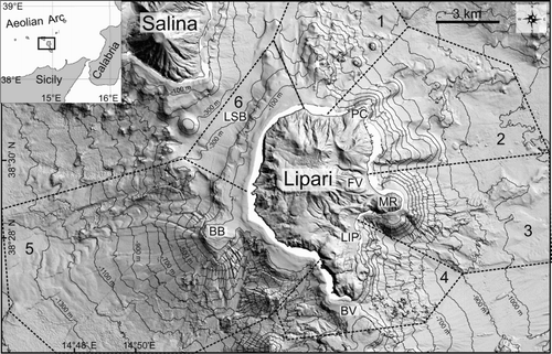
Figure 1. Shaded relief map of Lipari edifice (isobaths every 100 m). Dashed polygons point out the sectors where cumulative slope gradients were computed. BV: Bocche di Vulcano, LSB: Lipari-Salina Basin; LIP: Lipari village; MR: Monterosa, FV: Forgia Vecchia, PC: Punta della Castagna.
Lipari Island is the tip of a large stratovolcano that extends down to 1300 m water depth. Despite the fact that submarine portions account for about 80% of the edifice, only the general setting of such portions (CitationRomagnoli et al., 2013b) or specific features (CitationCasalbore, Bosman, Romagnoli, and Chiocci, 2014b, Citation2014c; CitationGamberi, 2001) have been described so far.
The aim of this paper is to provide a detailed and extensive map of the main submarine morphological features offshore Lipari Island based on the analysis of high-resolution multibeam data. The study allows us to demonstrate the interplay between constructive and destructive processes that led to the present-day morphology of the submarine volcanic edifice, as well as providing useful information on the main geohazard-related features offshore the largest and most densely populated island of the Aeolian Archipelago.
2. Data and methods
Morphological mapping was undertaken for the submarine portions of Lipari by interpreting volcanic and erosive-depositional features from a Digital Elevation Model (DEM, and main map). The DEM is the result of several multibeam surveys carried out around Lipari island over the last 10 years aboard the R/V Urania and Thetis (CNR) by CNR-IGAG, Sapienza University of Roma and University of Bologna. Bathymetric data were acquired with a Multibeam Reson Seabat 8160, 8111 and Kongsberg EM710, working at frequencies between 50 and 100 kHz. All data were geolocated using DGPS (Differential GPS) and processed with dedicated software (Caris Hips&Sips 8.1.7), taking into account repeated calibration of transducers in areas close to the survey zone and daily sound speed profiles. Data density and resolution decrease from the coastal sector towards the base of edifice, thus the cell size of the DEMs range from 1 m in shallow-water (<−100 m) to 25 m in deep water (down to −1300 m). A final DEM gridded at 25 m was used for the production of the morphological map, though the interpretation of the features was performed using data at the highest possible resolution. The subaerial DEM has a cell-size of 5 m and was produced by the reprocessing of Regional Cartographic Services data.
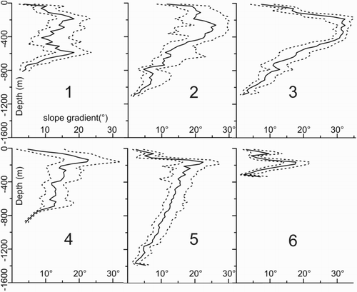
A slope gradient map of the Lipari offshore (inset on the Main Map) was computed from the DEM by calculating the direction of steepest descent or ascent at each grid cell. Graphs of the median and inter-quartile range of cumulative surface gradients (according to CitationMitchell, Masson, Watts, Gee, & Urgeles, 2002; ) were also produced to summarize the average steepness and slope variability versus depth in the different sectors of Lipari offshore.
Figure 2. Cumulative slope gradients according to CitationMitchell et al. (2002). Slope gradients within each area (see for division) were sorted according to depth intervals of 25 m, and a slope cumulative distribution was calculated for each depth interval. Continuous line indicates 50% percentile (median) of the distribution, while dash line is used for 25% and 75% of the distribution.
3. Geomorphological map of Lipari offshore
The base of the Lipari edifice lies at about −1100 and −1300 m in the western and eastern part, respectively ( and Main Map). A shallow saddle known as Bocche di Vulcano (minimum depth of ≈50 m) connects Lipari to Vulcano to the south, whereas a deeper sill at depth of ≈−300 m connects Lipari to Salina to the northwest (Lipari-Salina Basin in ).
The submarine flanks have average slope gradients decreasing from 20°–30° in the upper slope to a few degrees at the base of the edifice (). Low gradients are also present in the first −120/−140 m in the western and northern part of the edifice (upper part of sectors 5 and 6 in ), where a wide insular shelf interrupts the morphological continuity between subaerial and submarine flanks (, (a) and (b)). This is also observed in sector 3, where the shallower portions (<−200 m) show low gradients due to an insular shelf around the Monte Rosa Promontory (MR in ). At greater depths, two different types of flank can be identified (): the first type, encompassing sectors 1, 2 and 4, is characterized by an uneven morphology of volcanic slopes, causing a large variability in slope gradients, similarly to that observed for constructional flanks of the nearby Stromboli and Vulcano insular volcanoes (CitationCasalbore, Romagnoli, Chiocci, & Frezza, 2010; CitationRomagnoli, Casalbore, Bosman, Braga, & Chiocci, 2013a). The second type (sectors 3 and 5) is characterized by slope values in a narrower range, decreasing linearly with depth. This distribution is similar to the portions of Stromboli and Volcano flanks that were ‘smoothed’ by the emplacement of mass-wasting deposits. Finally, a very peculiar distribution characterizes the area between Lipari and Salina (sector 6), where slope gradients are comprised in a narrow and roughly symmetrical range, but do not vary linearly with depth. This distribution reflects the presence of a steeper area (between −130 and −250 m) that is comprised between two gently sloping areas characterizing the insular shelf and the Lipari-Salina Basin, respectively.
Figure 3. Morphological map of Lipari offshore, showing the main volcanic and erosive-depositional features.
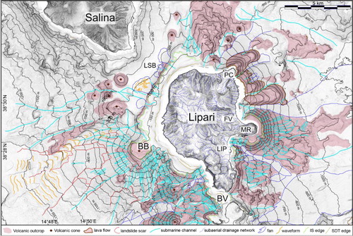
Below, a synthetic description of the main geomorphological features of the Lipari offshore is presented ( and the Main Map). It is worth noting that the lack of extensive ground-truth data did not allow a precise lithological classification of mapped features.
3.1. Volcanic morphologies
A suite of volcanic morphologies is present offshore Lipari, including volcanic cones, lava flows and bedrock outcrops ().
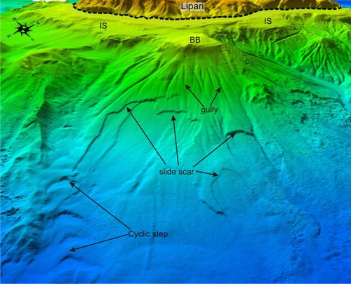
Volcanic cones are mainly located in the western part of the edifice, roughly aligned SSE-NNW ( and (b)). The cones have diameters of 1–5 km, covering areas of 3–30 km2 individually, and about the 20% of the Lipari western flank as a whole. The flanks of these cones are largely affected by a radial network of narrow gullies up to their top, the latter is often represented by a small flat surface. In the case of Banco del Bagno (BB in (b) and 5), this flat top is very large and laterally merges (−100/−120 m) with the insular shelf that surrounds Lipari island, likely sharing a similar origin (section 3.2). Other smaller, scattered volcanic cones are present in the northern and north-eastern part of the edifice, showing diameters of 0.5–1 km ( and (a)). The height/width ratio of the cones generally ranges between 0.1 and 0.3.
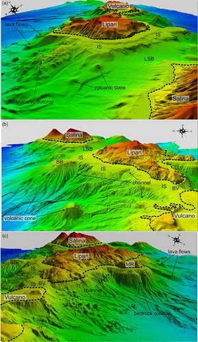
Figure 4. 3-D view (vertical exaggeration 1,5×) of the northern (a), south-western (b), and south-eastern flank (c) of Lipari, where the main volcanic and erosive-depositional features are recognizable. Dashed black line indicates the coastline. IS: insular shelf, BB: Banco del Bagno, MR: Monterosa, LSB: Lipari-Salina Basin, BV: Bocche di Vulcano. Shallow-water gaps on multibeam were filled up to improve readability of the images.
Lava flows are lobate features mainly found in the north-eastern part of the edifice, extending from the coast down to −750/−850 m. Here they are up to ≈3 km long and over 1 km wide, covering an area of ≈3 km2, and they are interpreted as the offshore extent of the subaerial obsidian-rich lava coulees described in CitationForni et al. (2013). They are up to 300 m high above the surrounding seafloor and their flow seems to be driven by the regional submarine slope.
Bedrock outcrops are morphological highs of very variable shape; they show an overall radial distribution around the island and are often marked by a degraded morphology due to post-eruptive erosional processes. Therefore, they are interpreted as erosional remnants resulting from marine erosive activity. They are commonly observed in the older sectors of Lipari, either near to the coast, where subaerial structures, such as the Monterosa Promontory, continue offshore in the eastern part of Lipari ((c)) or at depth as isolated morphological highs, such as in the northern part of the edifice ((a)).
3.2. Erosive-depositional features
Lipari island is surrounded by a relatively flat insular shelf (IS in and ), i.e. an erosional submerged surface extending from the coastline to the lowest level of wave erosion during glacial stages (CitationTrenhaile, 2001). The shelf is well-developed in the north-western and western part of the edifice as well as in the saddle between Lipari and Vulcano, where it is 1–2 km wide, with the shelf edge at −120/−150 m ((a)). In contrast, the shelf cannot be mapped on the eastern part of Lipari, the only exception being the older Monterosa Promontory, where the shelf is relatively narrow (around 700 m wide, (c)).
As the shelf was produced or re-worked during the last glacial maximum (and possibly previous low stands of sea level), its presence denotes an age older than 20,000 years for the related volcanic units. In contrast, its absence points to a younger age for successive volcanic and erosional processes that re-shaped the submarine flank more recently.
The insular shelf is commonly overlaid by terraced depositional bodies (SDT in ) trending parallel to the coast and exhibiting a cross-strike wedge-shaped geometry, with an internal prograding structure. These sedimentary terraced bodies are a common feature in the Aeolian insular volcanoes, where they were mapped using high-resolution seismic profiles (CitationChiocci & Romagnoli, 2004).
Other erosive-depositional features include slide scars and related deposits, channelized features, fan-shaped deposits and seafloor wavy bedforms.
Landslide scars tens/hundreds of meters wide are observed at the outer edge of both the insular shelf and the submarine terraced depositional bodies; related landslide deposits are often lacking either because they can be below the resolvable limits of the multibeam system or because mass-wasting processes produced gravity flows. A larger, nested landslide scar complex affects the western flank of Banco del Bagno volcanic cone (). Here, landslide scars are 2.5–4 km long and 1–2 km wide, extending over areas of 10 km2; their headwall is made up of steep scarps with relief of 10–20 m. The shape of the scarps points to mass-wasting processes occurring on a stratified seafloor with dominant retrogressive evolution. Related landslide deposits form a wide bulge at the base of the slope, covering an area of ≈14 km2.
Figure 5. 3-D view of the Banco del Bagno volcanic cone in the western part of Lipari, where nested slide scars, gullies and waveforms (cyclic steps) are present. Dashed black line indicates the coastline BB: Banco del Bagno, IS: insular shelf.
Channelized features largely vary in size, from small and narrow gullies radially cutting the flanks of volcanic cones ( and ) to over 10 kilometers-long channels draining the entire flank of the edifice ( and ). The channels commonly indent the insular shelf in the western part of Lipari ((b)), whereas in the eastern part, where the shelf is absent, they are incised close to the coast ((c)), likely in relation with the morphological evolution of the subaerial flank. It is worth noting that the protruding headland of Monterosa is bounded to the north and south by two major incisions, with the southern one creating the bay delimiting Lipari village (LIP in ). Because erosive processes are active within this major erosional feature, they pose a major threat for coastal infrastructure (i.e. harbors, densely inhabited seafront).
Fan-shaped deposits have been recognized at the foot of channelized features, ranging in width from some hundreds of meters up to several kilometers. The development of the fans is always related to a marked decrease of slope gradients from 15°–30° to 6°–10°, similarly to that observed at Stromboli and Vulcano (CitationCasalbore et al., 2010, CitationRomagnoli et al., 2013a). Their smoothed acoustic facies, with lack of hummocks, suggests that they are due to a continuous feeding of eroded debris rather than to catastrophic mass-wasting episodes (i.e. debris avalanche).
Seafloor wavy bedforms have been observed within the floor of channelized features and on the top of fan-shaped features developed on the western and north-western part of Lipari (). They have a wave length of 40–100 m, a wave height of several meters and a lateral extent of 70–150 m. In cross-section, they show a stepped morphology, defined by a flat stoss side and a steeply sloping lee side (gradients of 10°–25°). The largest waveforms have been observed within the channel floor that border the N flank of Banco del Bagno, with a wave length of 400–700 m, a wave height of 8–12 m and a lateral extent of 800–1300 m (). These features have been recently interpreted as cyclic steps by CitationCasalbore, Bosman, Romagnoli, and Chiocci (2014c), i.e. a class of slowly upslope migrating turbiditic sediment waves, where each downward step is bounded by a hydraulic jump (CitationKostic, 2011 and reference therein).
4. Conclusions
The morphological map presented in this work shows the main volcanic and erosive-depositional features that characterize the submarine portions of Lipari Island. A remarkable morphological difference exists between the western and eastern part of the volcanic edifice, mostly reflecting the different age of the two sectors. The western part is, in fact, characterized by the development of a wide insular shelf (older than 20 ka), in agreement with the older age of the volcanic units outcropping in this part of the island (267–43 ka, CitationForni et al., 2013). Offshore, on the western flank a NNW-SSE alignment of volcanic cones is consistent with the trend of the main tectonic features that led to the development of volcanism in the whole central sector of the Aeolian Archipelago (CitationRomagnoli et al., 2013b). These cones represent part of a larger volcanic belt flanking the western sides of both Lipari and Vulcano, and extending to Salina Island, and considered to represent an earlier stage of volcanic activity in the Central Aeolian sector (CitationRomagnoli, Calanchi, Gabbianelli, Lanzafame, & Rossi, 1989). Evidence of an early development of the cones are: (a) their degraded morphology, with flanks carved by a dense network of gullies, (b) the presence of a flat surface cutting their summit (if in the depth range of wave erosion during the Late Quaternary), and (c) a relevant sedimentary cover at their top. In contrast, the submarine eastern part of Lipari seems to be significantly younger as it is characterized by the lack of a well-developed insular shelf, present only around the submarine portion of the Monterosa Promontory dated to 119 ka (CitationForni et al., 2013). In this sector, the most striking features are represented by two spectacular, wide (over 1 km) and thick (up to 300 m), lava flows that develop for several kilometers down to −800/−900 m. They are clearly connected to the large subaerial obsidian-rich lava coulees outcropping between Forgia Vecchia and Punta della Castagna ( and ), having an age ≤8.6 ka (CitationForni et al., 2013). These subaerial coulees are well-known from prehistoric time, as they represented together with Pantelleria, Palmarola and Sardinia one of the main sources of obsidian (the so-called ‘dark gold’) in the Mediterranean during the Neolithic (CitationTykot, 2002).
A large spectrum of erosive-depositional morphologies ranging at different scales (from tens up to several kilometers in length/width) is observed on the submarine flanks of Lipari. Landslide processes are commonly represented by small landslides affecting the outer edge of the insular shelf and overlying submarine depositional terraces, similarly to that observed for the nearby Stromboli and Vulcano islands (CitationCasalbore, Romagnoli, Bosman, & Chiocci, 2011; CitationRomagnoli et al., 2013a), and at Terceira Island, Azores (CitationChiocci et al., 2013; CitationQuartau et al., 2014). Clear evidence of large-scale sector collapses are lacking at Lipari, different from that reported in the nearby Stromboli edifice (CitationRomagnoli, Casalbore, Chiocci, & Bosman, 2009a; CitationRomagnoli, Kokelaar, Casalbore, & Chiocci, 2009b), whereas wide translational slides are only present on the submarine flank of the Banco del Bagno volcanic cone. This morphology is, indeed, typical of slide scars affecting the submarine flanks of old and extinct volcanoes and open continental slopes (e.g. CitationCasalbore, Bosman, Martorelli, Sposato, & Chiocci, 2014a; CitationLastras et al., 2006).
The submarine drainage is often characterized by a slightly divergent or radial network of gullies the upper slope, coalescing downslope into main channels that drain the entire volcanic flank. This drainage network is controlled by the presence of volcanic outcrops and the insular shelf. It is different with respect to the subaerial one, where only narrow and short creeks are present ( and Main Map; CitationTripodo et al., 2012).
Unfortunately, no information is available on the age of the mass-wasting events. However, it is noteworthy how the morphology of active volcanic flanks is often characterized by a very high resilience (CitationChiocci, Romagnoli, Bosman, 2008), so that the widespread presence of scars, incisions and waveforms indicate very active mass-wasting processes on the submarine portions of Lipari volcanic edifice. Therefore, the morphological evolution of these features should be carefully monitored, as they might represent future marine geohazard due to their retrogressive evolution and proximity to the coastline.
Software
Caris Hips&Sips 8.1.7 was utilized to process the multibeam data and generate the marine DEM, while Global Mapper 15 was used to visualize data using shaded relief maps, contour maps and slope gradient maps in order to perform morphological analyses, and extract morphological features from the DEM. The design of the final map was performed using Adobe Illustrator.
Morphological map of Lipari offshore
Download PDF (33.1 MB)Acknowledgements
Officials and crews of R/V Urania and Thetis are gratefully acknowledged along with the researchers and students taking part in the surveys. Special thanks are due to Cristian Montanaro for help in the mapping of the morphological features offshore Lipari island and Andrè Fascetti for data processing. We also thank P. Baldi for the terrestrial DEMs of the islands, that were produced by the reprocessing of Regional Cartographic Services data and aerial photogrammetry provided by Dipartimento di Fisica (Settore Geofısica), University of Bologna. We gratefully acknowledged Alessio Rovere, Domenico Ridente and Chandra Jayasuriya for their suggestions that improved the quality of the paper and Main Map.
Funding
This research was funded by the National MaGIC Project (Marine Geohazards along the Italian Coasts, CitationChiocci & Ridente, 2011) and carried out in as part of the RITMARE (Ricerca ITaliana per il MARE) Project.
References
- Casalbore, D., Bosman, A., Martorelli, E., Sposato, A., & Chiocci, F. L. (2014a). Mass wasting features on the submarine flanks of Ventotene volcanic edifice (Tyrrhenian Sea, Italy). In Krastel et al. (Eds), Submarine Mass movements and their consequences, 6th International Symposium. Advances in Natural and Technological Hazards Research, 37, 285–293.
- Casalbore, D., Bosman, A., Romagnoli, C., & Chiocci, F. L. (2014b). Submarine mass-movements on volcanic islands: Examples from the Aeolian Archipelago (Italy). In Lollino et al. (Eds). Proceedings of the XII IAEG Congress. Springer.
- Casalbore, D., Bosman, A., Romagnoli, C., & Chiocci, F. L. (2014c). Large-scale seafloor waveforms on the flanks of insular volcanoes (Aeolian Archipelago, Italy), with inferences about their origin. Marine Geology, 355, 318–329.
- Casalbore, D., Romagnoli, C., Bosman, A., & Chiocci, F. L. (2011). Potential tsunamigenic landslides at Stromboli Volcano (Italy): Insights from marine DEM analysis. Geomorphology, 126, 42–50.
- Casalbore, D., Romagnoli, C., Chiocci, F., & Frezza, V. (2010). Morpho-sedimentary characteristics of the volcanic apron around Stromboli volcano. Mar Geol, 269, 132–148.
- Chiocci, F. L., & Ridente, D. (2011). Regional-scale seafloor mapping and geohazard assessment. The experience from the Italian project MaGIC (Marine Geohazards along the Italian Coasts). Mar Geophys Res, 32, 13–23.
- Chiocci, F. L., & Romagnoli, C. (2004). Terrazzi deposizionali sommersi nelle Isole Eolie. Memorie Descrittive della Carta Geologica d' Italia, 58, 81–114.
- Chiocci, F. L., Romagnoli, C., & Bosman, A. (2008). Morphologic resilience and depositional processes due to the rapid evolution of the submerged Sciara del Fuoco (Stromboli Island) after the December 2002 submarine slide and tsunami. Geomorphology, 100(3–4), 356–365.
- Chiocci, F. L., Romagnoli, C., Casalbore, D., Sposato, A., Martorelli, E., Alonso, B., Casas, D., et al. (2013). Bathy-morphological setting of Terceira Island (Azores) after the FAIVI cruise. Journal of Maps, 9, 590–595.
- Forni, F., Lucchi, F., Peccerillo, A., Tranne, C. A., Rossi, P. L., & Frezzotti, M. L. (2013). In F. Lucchi, A. Peccerillo, J. Keller, C. A. Tranne, & P. L. Rossi (Eds.), The Aeolian Islands Volcanoes (Vol. 37, pp. 213–279). London: Memoirs Geological Society.
- Gamberi, F. (2001). Volcanic facies associations in a modern volcaniclastic apron (Lipari and Vulcano offshore, Aeolian Island Arc). Bulletin of Volcanology, 63, 264–273.
- Kostic, S. (2011). Modeling of submarine cyclic steps: Controls on their formation, migration and architecture. Geosphere, 7, 294–304.
- Lastras, G., Canals, M., Amblas, D., Ivanov, M., Dennielou, B., Droz, L., Akhmetzhanov, A., & TTR-14 Leg 3 Shipboard Scientific Party. (2006). Eivissa slides, western Mediterranean Sea: Morphology and process. Geo-Marine Letters, 26, 225–233.
- Mitchell, N. C., Masson, D. G., Watts, A. B., Gee, M. J. R., & Urgeles, R. (2002). The morphology of the submarine flanks of volcanic ocean islands. A comparative study of the Canary and Hawaiian hotspot islands. J. Volcanol. Geotherm. Res., 115, 83–107.
- Quartau, R., Hipolito, A., Romagnoli, C., Casalbore, D., Madeira, J., Tempera, F., Roque, C., & Chiocci, F. L. (2014). The morphology of insular shelves as a key for understanding the geological evolution of volcanic islands: Insights from Terceira Island (Azores). Geochem. Geophys. Geosyst., 15(5), 1801–1826. doi:10.1002/2014GC005248
- Romagnoli, C., Calanchi, N., Gabbianelli, G., Lanzafame, G., & Rossi, P. L. (1989). Contributi delle ricerche di geologia marina alla caratterizzazione morfostrutturale ed evolutiva dei complessi vulcanici di Salina, Lipari e Vulcano (Isole Eolie). Bollettino Gruppo Nazionale Vulcanologia, 2, 971–978.
- Romagnoli, C., Casalbore, D., Bortoluzzi, G., Bosman, A., Chiocci, F.L., D'Oriano, F., Gamberi, F., Ligi, M., & Marani, M. (2013b). Bathy-morphological setting of the Aeolian Islands. In F. Lucchi, A. Peccerillo, J. Keller, C. A. Tranne, & P. L. Rossi (Eds.), The Aeolian Islands Volcanoes (Vol. 37, pp. 27–36). London: Memoirs Geological Society.
- Romagnoli, C., Casalbore, D., Bosman, A., Braga, R., & Chiocci, F. L. (2013a). Submarine structure of Vulcano volcano (Aeolian islands) revealed by high-resolution bathymetry and seismo-acoustic data. Mar Geol, 338, 30–45.
- Romagnoli, C., Casalbore, D., Chiocci, F. L., & Bosman, A. (2009a). Offshore evidence of large-scale lateral collapses on the eastern flank of Stromboli, Italy, due to structurally-controlled, bilateral flank instability. Mar Geo, 262, 1–13.
- Romagnoli, C., Kokelaar, P., Casalbore, D., & Chiocci, F. L. (2009b). Lateral collapses and active sedimentary processes on the northwestern flank of Stromboli volcano, Italy. Mar Geo, 265, 101–119.
- Trenhaile, A. S. (2001). Modelling the Quaternary evolution of shore platforms and erosional continental shelves. Earth Surface Processes and Landforms, 26, 1103–1128.
- Tripodo, A., Casella, S., Pino, P., Mandarano, M., & Rasa, R. (2012). Geomorphological map of the Lipari volcanic island (Aeolian Archipelago – Italy). Journal of Maps, 8, 107–112.
- Tykot, R. H. (2002). Chemical fingerprinting and source tracing of obsidian: The central Mediterranean trade in black gold. Accounts of Chemical Research, 35, 618–627.
- Ventura, G., Vilardo, G., Milano, G., & Pino, N. A. (1999). Relationships among crustal structure, volcanism and strike-slip tectonics in the Lipari–Vulcano Volcanic Complex (Aeolian Islands, Southern Tyrrhenian Sea, Italy). Physics of the Earth and Planetary Interiors, 116, 31–52.