
Abstract
Physiographic maps summarize and group the landforms of a territory into homogeneous areas in terms of kind and intensity of the main geomorphological process. These maps are often produced at semi-detailed scales, while examples at the regional scale are much less common. However, because the region is the main administrative level in Europe, physiographic maps can be very useful for land planning in many fields, such as ecological studies, risk maps, and soil mapping. This work presents a methodological example of a regional physiographic map, compiled at a 1:250,000 scale, representing the whole Sicilian region, the largest of the Mediterranean islands. The physiographic units were classified according to the geomorphological processes that were identified by stereo-interpretation of aerial photographs. In addition, information from other published maps, representing geomorphological landforms, eolian deposits, anthropic terraced slopes, and landslide were used to improve the accuracy and reliability of the map.
1. Introduction
The term ‘physiography’ was originally used to mean ‘study of the nature or of natural phenomena’, but later it was specifically used in the studies of physical geography and geomorphology (CitationFairbridge, 1968). The first physiographic study was carried out by CitationFenneman (1917), who proposed a classification of physiographic units of the USA. The famous cartographer, Raisz, was the inventor of physiographic maps, which he called landform maps (Citation1931). He produced a large number of maps, principally of the USA (CitationRaisz, 1957), but also of all the other continents. Since these pioneer studies, published physiographic maps are rather infrequent, unlike geomorphological maps, and most examples still come from the USA (CitationBailey, 1999; CitationReger & Cleaves, 2008; CitationSchaetzl et al., 2013).
The main purpose of physiographic maps is to delineate territories that have physical uniformity with respect to landscape and landforms, or rather include more complex associations of landforms dominated by similar geomorphic processes and evolutionary history. The uniformity of a physiographic unit is related to the level of subdivision, and therefore to the mapping scale (CitationPain, Gregory, Wilson, & McKenzie, 2011).
Compared to geomorphological maps, physiographic maps depict a spatial and synthetic representation of landforms, but they do not report abrupt or linear geomorphological processes, such as faults, landslide bodies, rills, and gullies, amongst others. They can be derived from the spatial generalization of geomorphological information (CitationCostantini, 2007), since map units, namely land, landform, or landscape units, are traits of land relatively homogeneous in terms of kind and intensity of one or more geomorphological processes.
Most physiographic maps depict large territories and are at the national (CitationBailey, 1999; CitationReger & Cleaves, 2008; CitationSchaetzl et al., 2013) or continental scale (CitationEschweiler, 1993; CitationPain et al., 2011; CitationVan Lynden, 1994). Recently, in Italy, CitationColtorti, Firuzabadì, and Pieruccini (2011) published a landform unit map at the province scale of the Siena territory (Central Italy) and CitationSmiraglia et al. (2013) published a land unit map of Italy.
As far as soil mapping is concerned, CitationChristian and Stewart (1953) performed a pioneer scientific work, in which they linked soil typologies to land units and land systems, using a physiographic approach. Indeed, it is widely demonstrated that soil pattern and landscape elements are closely related (CitationGerrard, 1992). CitationUNEP-IUSS-ISRIC-FAO (1995) published the first procedures manual for global and national soils and terrain digital databases, called SOTER. They divided the landform units at two levels: the first for describing the landscape (flat land, sloping land, steep land, etc.) and the second for describing the landform (plateau, valley floor, dissected plain, etc.).
Although physiographic maps were originally developed for educational purposes, they also possess high value for land planning applications in fields such as civil engineering, urban settlement, natural hazards, agro-ecology, and pedology, amongst others (CitationDobos, Micheli, Baumgardner, Biehl, & Helt, 2000; CitationEl Baroudy, 2011; CitationMartín-Duque et al., 2003; CitationSmiraglia et al., 2013). The high value of physiographic maps is due to their clarity not only for specialists of different disciplines, but also for stakeholders and lay people. Thus physiographic maps offer a great opportunity for cooperation between science and application areas to establish a common view on the forms of the landscape. Physiographic legends should provide easy and efficient ways to facilitate an overview of the main landforms of a territory and to understand its landscape development.
The main purpose of this mapping work was to produce a physiographic map of the Sicilian region at a 1:250,000 scale, using a legend that could also be applied in other Mediterranean countries (see Main Map).
2. Study area
The administrative territory and geographic territory of the Sicilian region are composed of different islands: the main island of Sicily, some archipelagos, and isolated islands. The mainland of Sicily covers an area of about 25,441 km2 and is the largest island in the Mediterranean Sea. The surrounding islands are subdivided into three archipelagos and two isolated islands, namely Ustica (8.7 km2) and Pantelleria (83 km2). The largest archipelago is the Aeolian, formed by seven main islands (about 115 km2), followed by the Egadi (three main islands of 37.5 km2) and the Pelagie (two main islands of 25.5 km2).
The region is mainly hilly, although there are large coastal plains, namely Catania and Gela plains, and important mountain chains. The most important chains are Peloritani and Nebrodi mounts in the north-east, Madonie in the north, and Sicani mounts in the south-west. Sicily has also important volcanos, whether active like Etna (3.340 m a.s.l.) and Stromboli, quiescent like Pantelleria and Vulcano islands, or inactive like Linosa, Ustica, Lipari, Salina, Alicudi, and Filicudi islands.
The climate is typically Mediterranean to subtropical, characterized by warm-dry summers and cool-wet winters (CitationCostantini, Fantappié, & L'Abate, 2013). The mean annual temperature ranges between 19 and 20°C in the coastal area, to 14–16°C inland, and 8–10°C on the highest mountains (Madonie, Nebrodi, Peloritani, Sicani, and Etna volcanoes). The annual precipitation is usually lower than 700 mm, concentrated in the late autumn and early spring. The northern (Tyrrhenian Sea) and western coasts (Ionian Sea) are slightly wetter, with an annual precipitation that can reach 800–900 mm near the mountains.
3. Methods
The physiographic map was compiled by matching stereoscopic interpretation of aerial photographs at a 1:70,000 scale with different thematic layers: geology at a 1:100,000 scale, Normalized Difference Vegetation Index analysis at a resolution of 30 m, Digital Elevation Model (DEM) at a resolution of 20 m, topography at a 1:250,000 scale, and land cover at a 1:100,000 scale. Physiographic units were created generalizing evidence of geomorphological processes, so as to delineate areas with the greatest uniformity and significance for the purpose of soil mapping. The legend of the physiographic map is that used for the soil subsystems of Italy (CitationCostantini, 2007).
The prevalent geomorphological process was determined to be the most recent, and to have had the most obvious effect on pedogenesis. For example, erosional slope landforms were preferred to structural ones, in cases where the two processes were recognized to be present. The karstic nature of coastal landforms was recognized by its effect on the pedogenesis of red eluviated soils.
After a preliminary physiographic map obtained by the traditional aerial photography interpretation, new information layers were added to improve the final map, and they are: (i) the delineation of Aeolian deposits, which were drawn on the basis of the soils map of Sicily of CitationFierotti, Dazzi, & Raimondi (1988) and of the accompanying publication (Fierotti, Citation1997); (ii) the presence of anthropogenic terraced slopes within the physiographic units, using the map of terraced landscapes of Sicily (CitationBarbera, Cullotta, Rossi-Doria, Rühl, & Rossi-Doria, 2010); and (iii) the presence of landslides within the physiographic units, using the ‘Inventory of Landslide Phenomena in Italy’ (CitationISPRA, 2008).
Urban areas were discovered from the CORINE land cover map of Sicily (CitationDe Jager, 2012). The hill-shade, discovered from the regional DEM, was placed below the physiographic map to obtain a quasi-3D effect and to highlight topography. Finally, topographic information such as the main rivers, the mountain ranges with the main mountain peaks, the principal towns, and gulf names are included.
The Main Map was compiled at a 1:250,000 scale, which is the reference scale for regional policy-makers. The final map was checked and validated through field surveys and matched with several published geomorphological maps at a local scale (CitationAgnesi, Di Maggio, & Macaluso, 1995; CitationAgnesi, Di Maggio, Macaluso, Madonna, & Messana, 2000; CitationAgnesi, Cappadonia, & Conoscenti, 2007; CitationCiampalini et al., 2013; CitationConoscenti et al., 2013; CitationDaina et al., 1979; CitationDi Maggio, 2000; CitationGiorgianni, Giunta, & Pipitone, 1997; CitationMonteleone, Pipitone, & Sabatino, 2000, Citation2004; CitationMonteleone, Sabatino, & Bambina, 2006; CitationSabatino & Monteleone, 2006; CitationPulice et al., 2012).
4. Geology
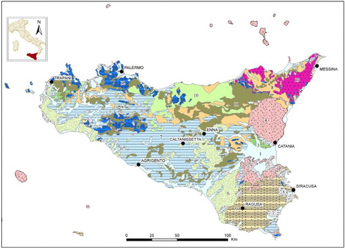
The geological structure of the Sicily region can be summarized as a large-scale arc formed by three tectonostratigraphic domains (CitationSperanza et al., 1999): the southern termination of the Calabro-Peloritan arc in the Peloritan ridge (Messina province), the Maghrebian thrust belt in central and western Sicily, and the Hyblean platform in the south-east, Ragusa, and Siracusa provinces ().
Figure 1. Lithological sketch of Sicily region. 1 – Recent alluvial deposits and beaches (Holocene); 2 – Dunes and eolian deposits (Holocene–Pleistocene); 3 – Fluvial and fluvio-lacustrine terraced deposits (Pleistocene); 4 – Volcanic and pyroclastic rocks (Neogene–Holocene); 5 – Detrital limestone and beach deposits (Pliocene–Pleistocene); 6 – Marine sands and conglomerates (Pliocene–Pleistocene); 7 – Marine clays, silty clays, and marls with evaporites (Miocene–Pleistocene); 8 – Marls sandstone and arenaceous-pelitic flysches (Miocene); 9 – Biocalcarenites, limestones, and marls (Paleogene–Miocene); 10 – Arenaceous flysches (Paleogene); 11 – Clayey-calcareous flysches (Cretaceous–Paleogene); 12 – Limestones, dolonstones, marls, and calcareous flysches (Permian–Jurassic); 13 – Phyllites, schists, gneiss, and quartzite, from low- to high-grade metamorphic, of Calabride–Peloritan unit (Triassic–Jurassic).
The Calabro-Peloritan arc is characterized by low- and high-grade metamorphic rocks, namely phyllites, micashists with subordinate quartzites, marbles, gneiss, and migmatites with alpine metamorphic imprinting.
The Maghrebian thrust belt can be divided into two regional domains: Gela Nappe and Maghrebian Units. The latter is mainly characterized by Mesozoic calcareous rocks as limestones, cherty-limestones, dolostones and Cretaceous–Oligocene marly-calcareous, or arenaceous flysches. These formations outcrop in the structural ridges, namely the Sicani and Madonie mountains. The Gela nappe is a series of piggy-back and foreland basins gradually deformed since the Miocene during the Alpine–Appennine orogenesis (CitationVitale, 1998). The sedimentary formations are mainly characterized by Cenozoic-Quaternary terrigenous sediments, namely marly-limestone, marls and sandstones in turbiditic facies (Oligocene–Miocene), as well as organogenic limestone, sands, conglomerates, clays, and evaporites (Late Miocene–Pleistocene).
Several episodes of volcanic activity also occurred in south-eastern Sicily from Miocene to the present. The magmatic provinces of Sicily can be divided into the Aeolian arc (0.4 My B.P. to the present) and Sicily province (7.5 My B.P. to the present). The first consists of several strato-volcanoes forming the seven Aeolian islands and several seamounts. Rock composition ranges from mafic to silicic, mainly following the calc-alkaline and high-potassium calc-alkaline series (CitationPeccerillo, 2005): calc-alkaline basalts, andesites, latites and rhyolites, high-potassium calc-alkaline andesites, and trachytes. Recent volcanism activity is restricted to Stromboli Island and in the submarine zone at Panarea Island.
The magmatism of Sicily province consists of several volcanoes occurring in eastern Sicily (Etna volcano and Iblei mounts), Pantelleria, Linosa, and several seamounts in the Sicily channel. The petrochemical composition of the rocks (CitationPeccerillo, 2005) ranges between tholeiitic and Na-alkaline series, therefore tholeiitic basalts, trachybasalts (Etna), nephelinite (Iblei), per-alkaline ignimbrites, and alkali basalts (Pantelleria and Linosa).
5. Landform classification and map legend
A physiographic units’ legend was built up on the basis of the literature (CitationCostantini, 2007; CitationFairbridge, 1968; CitationShoeneberger, Wysocki, Benham, & Broderson, 2002) and taking into account the national geomorphological legend (CitationServizio Geologico Nazionale, 1994). The legend can be used at different scales and includes anthropogenic forms. The landforms were grouped on the basis of a geomorphological classification (CitationFairbridge, 1968) of the landforms into: anthropogenic, eolian, coastal, valley floor, intermountain fluvial, erosional slopes, structural, karstic, and volcanic, as follows (Main Map):
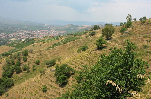
Figure 2. Terraced slopes along the Alcantara valley (northern slopes of Etna volcano).
(A) Anthropogenic landforms
Quarry area: open-air mining site and quarry deposits.
Terraced slope: slope reshaped by man to create terraces, protected either with stones or with herbaceous vegetation, made with the aim to preserve soil against erosion ().
(B) Aeolian landforms
(3) Dunes and Aeolian deposits: area characterized by the deposition of sandy materials by wind, depicted by bright tones. The morphology is often characterized by an elongated relief, usually asymmetric.
(C) Marine landforms
(4) Coastal plain: area of flat, low-lying land adjacent to the seacoast, influenced by marine and/or lacustrine erosional and/or depositional processes.
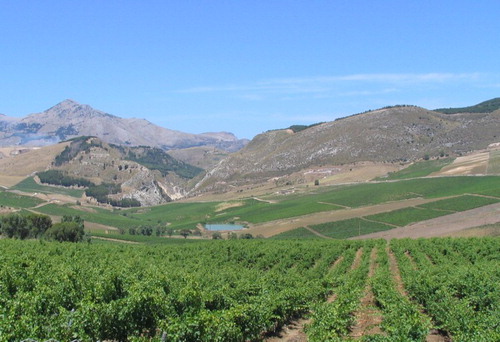
Figure 3. Vineyards in the Dirillo river valley in the southern coast (Gela gulf). In the background, the flat surface of the marine terrace is clearly visible.
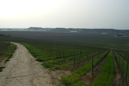
(5) Marine terrace: flat or wavy surfaces of marine origin, uplifted out of the sea during the Tertiary or Quaternary ().
(6) Marine abrasion platform: flat surface of abraded rocks developed during marine regressions in the Tertiary or Quaternary.
(D) Lacustrine landforms
(7) Marsh: lacustrine zone with shallow brackish water, high organic materials deposition, and low oxygenation, favoring peat development.
(8) Filled or reclaimed lacustrine plain: peat bogs or lakes of the inland areas, dried and filled with sediments.
(E) Fluvial landforms
(9) Flood plain: flat, wide, and periodically flooded land adjacent to rivers.
(10) Reclaimed flood plain: flooded land reclaimed by man for agricultural, industrial, or residential purposes.
(11) Fluvial terrace: remnants of ancient floodplains that existed when the river flowed at a higher elevation, before channel incision. The incision was caused by a lowering of the base level, mainly due to sea level fall or tectonic uplift.
(12) Dissected fluvial terrace: fluvial terraces in the plain eroded and cut by streams.
(13) Fluvial terrace with undulating surface: fluvial terraces in the plains, characterized by undulating surfaces caused by a sequence of erosional and depositional processes.
(14) Ephemeral stream bed (Fiumara): dry or ephemeral riverbed, typical of arid and semiarid regions (CitationSabato & Tropeano, 2004).
(15) Alluvial fan: fan- or cone-shaped deposit crossed and built up by streams, located at the mouth of a mountain front, formed when the stream gradient, and so stream power, decreases.
(16) Valley: stream valley between mountains, mainly characterized by depositional processes. The morphology is usually flat or slightly concave ().
(17) Canyon: V-shaped stream valley characterized by very steep and deep sides.
(18) Complex filled depression: basin or concave area filled with deposits of various kinds (fluvial, landslides, colluvial, etc.)
(F) Erosional slope landforms
(19) Convex slope or summit: segment of a slope characterized by a convex profile; the summit is the landform resulting from the joining of two convex slopes facing opposite valleys.
(20) Planation surface: flat surfaces which are the end product of a number of processes of planation by erosion, cutting the rock layers. These surfaces can be dissected by water channels.
(21) Scarp: steep to subvertical slope, cliff, caused by faulting or erosion of solid rocks.
(22) Linear slope: slope characterized by a linear and regular profile.
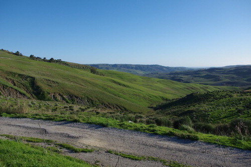
(23) Slope dissected by small valleys: generic term to indicate gentle slopes characterized by knolls and small valleys produced by ephemeral streams. This landform is typical of easily erodible materials, such as slope deposits, clays, and sands ().
(24) Slope with V-shaped valleys: slopes characterized by deep stream incision, forming V-shaped valleys.
(25) Uneven slope: slopes characterized by strong water erosion and instability, with common processes such as shallow landslides, solifluction, soil creep, rill, and gully erosion.
(26) Slope with diffuse erosion (sheet, rill): slopes characterized by strong sheet, rill, and sometimes gully erosion.
(27) Slope with landslides: slopes characterized by one or more landslide bodies, scarps, and trenches, caused by deep or shallow downslope movement.
(28) Badland: landform characterized by a very fine drainage network and short steep slopes with narrow interfluves, usually denudated and developed on clayey lithologies by gully erosion and by the action of gravity (mudflows).
(29) Rockfall talus: accumulation of rock fragments at the foot of steep slopes and cliffs.
Figure 4. Rural landscape of the inland hills on marine clays and silty clays, in the right side of the Belice river valley (Trapani). The gentle slopes are dissected by small valleys and they are characterized by diffuse erosion (gully erosion on the left of the picture) and small shallow landslides.
(G) Structural landforms
(30) Cuesta: asymmetric ridge, characterized by a steep face on one side and a gentle slope on the other. It is typical of gently tilted sedimentary rock layers consisting of alternating strata which have varying hardness and resistance to erosion, characterized by a homoclinal structure.
(31) Structural surface: elevated area of land with a flat top surface and sides that are usually steep cliffs, formed by differential erosion of hard rocks overlying softer rocks more prone to erosion (). Flat-topped hills with cliffs that change downward to slopes are also called ‘Mesa’.
(32) Undulating structural surface: structural surface with an undulating surface, due to several cycles of erosion and deposition.
(33) Dissected structural surface: structural surface cut by streams and small valleys.
(34) Irregular slope with fault scarps: irregular slope characterized by steps formed by tectonic activity.
(35) Fault scarp: steep slope or cliff formed by ancient or recent faulting.
(36) Tectonic depression: area, generally elongate, that has been lowered by fragile (graben) or ductile (synclinal fold) tectonic activity.
Figure 5. Structural surface of the monoclinal step-like fold in the limestone of Monte Scorace, near Trapani.
(H) Karst landforms
(37) Karst plateau: flat area of carbonate rocks characterized by common karst features of small dimensions. The karst features can be small dolines, swallow holes, karren, and dry and blind valleys.
(38) Karst slope: slope characterized by the previous karst features.
(39) Karst depression: large depression formed by karstic dissolution processes, namely doline, sinkhole, uvala, and polje.
(40) Fluviokarst valley: stream valley in a karst environment, characterized by deposition and ephemeral surface flow of water (dry valley and blind valley).
(41) Fluviokarst channel network area: flat or gently sloped surface, characterized by common small dry valleys.
(I) Volcanic landforms
(42) Volcanic plateau: wide and flat, or slightly undulating, area characterized by pyroclastic deposition or lava flow, for instance a basaltic plateau.
(43) Lava flow: slope characterized by lava flow deposition.
(44) Volcanic dome: roughly circular mound-shaped protrusion resulting from the slow extrusion of viscous lava from a volcano.
(45) Volcanic cone: cone-shaped hill or mountain built by material (ash, lapilli, scoria, and lava flows) from volcanic eruptions piled up around the main volcanic vent.
(46) Caldera: wide depression formed by the collapse of a previous volcanic edifice following a volcanic eruption, due to the emptying of the magma chamber beneath the volcano.
6. Conclusions
The 1:250,000 physiographic map of the Sicilian region depicts a summary of the landforms and geomorphological processes at a regional scale. This map can be used as an information layer together with other regional thematic mapping, for instance soils, ecological units, soil erosion risk, and geomorphological risk maps.
The geomorphology of Sicily is extremely variable and includes many landscapes resulting from interaction between geomorphological processes, tectonic movements, climatic changes, and human activity. It is possible to simplify the geomorphology of the region into five sectors, each corresponding to a typical assemblage of landforms and geomorphological processes, related to geological and structural settings, as follows:
Volcanic landscape: Etna volcano and the volcanic islands, namely Pantelleria, Aeolian, Ustica, and Linosa. In addition to the typical volcanic landforms such as craters, lava flows, and volcanic ash fields, the slopes of these areas are commonly characterized by anthropogenic terraces, used for viticulture, orchards, and fruit trees (CitationDazzi, 2007).
Coastline: mainly characterized by marine terraces, sand dunes, and flood plains. The widest flood plains are the Catania plain (Dittaino and Gornalunga rivers) and Gela plain (Gela and Maroglio rivers).
Hyblean platform: in the south-eastern part of the region, between Siracusa and Ragusa cities. It is a wide structural carbonate plateau between 450 and 600 m, dissected by many fluvial valleys and canyons. The carbonate nature of the rocks facilitates the formation of karst features such as dolines and fluviokarstic channels.
Calcareous mountains and hills: close to the southern coast, but also present around the Madonie and Sicani ridges. These are typical karst dissolution landscapes, characterized by dolines, fluviokarstic valleys, and canyons.
Inland hills: mainly formed on clay deposits and flysch formations. The main landforms are due to gravity (landslides) and water-driven slope erosion processes.
Nebrodi and Peloritan ridges: mountains and hills formed on massive rocks such as arenites and alpine metamorphic rocks (marbles, gneiss, schists, etc.). In this area, the slopes are very steep and have accentuated V-shaped valleys. Landslides are common in this area, particularly along the coastal slopes.
Software
The physiographic units were georeferenced and digitized using Esri ArcGIS. The map rendering was also carried out using ArcGIS, while the legend was edited using Microsoft Office Excel.
Physiographic map of the Sicilian Region - scale 1: 250,000
Download PDF (13.7 MB)Acknowledgements
We wish to thank the Sicilian region, in particular Marco Perciabosco, Gabriella Matranga, and Fabio Guaitoli, of the Agriculture department. Many thanks to Alessandra Giorgianni (Earth Science Department, University of Palermo), Michele Bocci and Giorgio Sacchi (Geographike s.r.l., Siena), and Massimo Paolanti and Rosa Rivieccio (Choros s.r.l., Roma) for technical support. The work was undertaken within the framework of the project ‘Soil mapping of Sicily region at 1:250,000 scale’, supported by the interregional program ‘Agricoltura & Qualità’ of the Italian Ministry of Agriculture and Forestry.
Related Research Data
References
- Agnesi, V., Di Maggio, C., & Macaluso, T. (1995). Deformazioni gravitative profonde e superficiali nella Penisola di Capo S. Vito (Sicilia occidentale). Memorie della Società Geologica Italiana, 50, 11–21.
- Agnesi, V., Di Maggio, C., Macaluso, T., Madonna, G., & Messana, V. (2000). Morphotectonic setting of the Madonie area (Central Northern Sicily). Memorie della Società Geologica Italiana, 55, 373–379.
- Agnesi, V., Cappadonia, C., & Conoscenti, C. (2007). Carta geomorfologica del bacino idrografico del Rio Spinasanta e note illustrative (Sicilia centro-settentrionale). Naturalista Siciliano, S. IV, XXXI(3–4), 127–145. Retrieved November 17, 2014, from http://www.sssn.it/PDF/PDF%20Nat.Sic.%203-4%202007/Agnesietalii.pdf.
- Bailey, C. M. (1999). Physiographic map of Virginia. College of William & Mary. Retrieved November 17, 2014, from http://web.wm.edu/geology/virginia/provinces/pdf/va_physiography.pdf.
- Barbera, G., Cullotta, S., Rossi-Doria, I., Rühl, J., & Rossi- Doria, B. (2010). I paesaggi a terrazze in Sicilia: metodologie per l'analisi, la tutela e la valorizzazione. ARPA Sicilia, Collana Studi e Ricerche n. 7, Palermo. 531 pp.
- Christian, C. S., & Stewart, G. A. (1953). General report on survey of Katherine-Darwin region, 1946. CSIRO, Land Research Series, n.1, Melbourne, Australia. Retrieved November 20, 2014, from http://www.publish.csiro.au/paper/LRS01.htm
- Ciampalini, R., Cigna, F., Del Ventisette, C., Moretti, S., Liguori, V., & Casagli, N. (2013). Integrated geomorphological mapping in the north-western sector of Agrigento (Italy). Journal of Maps, 8(2), 136–145.
- Coltorti, M., Firuzabadì, D., & Pieruccini, P. (2011). Geomorphological map and land units at 1:200,000 scale of the Siena province (Southern Tuscany, Italy). Journal of Maps, 7(1), 536–551.
- Conoscenti, C., Agnesi, V., Angileri, S., Cappadonia, C., Rotigliano, E., & Märker, M. (2013). A GIS-based approach for gully erosion susceptibility modelling: a test in Sicily, Italy. Environmental Earth Sciences, 70(3), 1179–1195.
- Costantini E. A. C. (Ed.). 2007. Linee guida dei metodi di rilevamento e informatizzazione dei dati pedologici. Firenze, Italia: CRA_ABP, pp. 296. Retrieved November 20, 2014, from http://soilmaps.entecra.it/download/pub-Linee_guida_2011.pdf.
- Costantini, E. A. C., Fantappié, M., & L'Abate, G. (2013). Climate and pedoclimate of Italy. In E. A. C. Costantini & C. Dazzi (Eds.), The Soils of Italy (pp. 19–38). Dordrecht, The Netherlands: Springer Science/Business Media.
- Daina, A., Macaluso, T., Monteleone, S., Pipitone, G., Vernuccio, S., Agnesi, V., & D'Angelo, U. (1979). Studio della franosità del Territorio di Agrigento. Carta della franosità (scala 1:50.000). Thematic Map, Assessorato Agricoltura e Foreste – Regione Siciliana, Azienda Foreste Demaniali, Istituto di Geologia – Facoltà di Scienze – Università degli Studi di Palermo.
- Dazzi, C. (2007). Environmental features and land use of Etna (Sicily–Italy). In: Ó. Arnalds, F. Bartoli, P. Buurman, H. Óskarsson, G. Stoops, & E. García-Rodeja (Eds.), Soils of volcanic regions in Europe (pp. 629–644). Heidelberg: Springer.
- De Jager, A. L. (2012). Preparing CORINE Land Cover data for use. Optimization of Land Cover data using a database and a topological GIS platform. European Commission, Joint Research Center, Institute for Environment and Sustainability. EUR 25163 EN. ISBN 978-92-79-22720-2 (print). Retrieved November 20, 2014, from http://publications.jrc.ec.europa.eu/repository/handle/111111111/23320
- Di Maggio, C. (2000). Morphostructural aspects of the central northern sector of Palermo Mountains (Sicily). Memorie della Società Geologica Italiana, 55, 353–361.
- Dobos, E., Micheli, E., Baumgardner, M. F., Biehl, L., & Helt, T. (2000). Use of combined digital elevation model and satellite radiometric data for regional soil mapping. Geoderma, 97(3), 367–391.
- El Baroudy, A. A. (2011). Monitoring land degradation using remote sensing and GIS techniques in an area of the middle Nile Delta, Egypt. CCa, 87(2), 201–208.
- Eschweiler, J. A. (1993). A draft physiographic map of Africa (at scale of 1:5 million). FAO internal publications, Rome, 46.
- Fairbridge, R. W. (1968). Land mass and major landform classification. In R. W. Fairbridge (Ed.), Geomorphology (pp. 618–626). Berlin: Springer.
- Fenneman, N. M. (1917). Physiographic subdivision of the United States. Proceedings of the National Academy of Sciences of the United States of America, 3(1), 17–22. doi:10.1073/pnas.3.1.17
- Fierotti, G. (1997). I suoli della Sicilia, con elementi di genesi, classificazione, cartografia e valutazione dei suoli. Flaccovio editore, Palermo, 84–85.
- Fierotti, G., Dazzi, C., & Raimondi, S. (1988). Carta dei suoli della Sicilia. Regione siciliana, Assessorato territorio ed ambiente.
- Gerrard, J. 1992. Soil Geomorphology. London: Springer, 269 pp.
- Giorgianni, A., Giunta, G., & Pipitone, G. (1997). Le caratteristiche tettoniche e morfologiche del territorio di Pollina (M.ti Madonie – Sicilia settentrionale) per una valutazione preliminare della pericolosità geologica. Naturalista Siciliano, S. IV, XXI(3–4), 167–186.
- ISPRA – Istituto Superiore per la Protezione e la Ricerca Ambientale. (2008). Landslides in Italy. Special report 83/2008, Rome, Italy. Retrieved November 17, 2014, from http://www.progettoiffi.isprambiente.it/cartanetiffi/
- Martín-Duque, J. F., Pedraza, J., Sanz, M. A., Bodoque, J. M., Godfrey, A. E., Diez, A., & Carrasco, R. M. (2003). Landform classification for land use planning in developed areas: an example in Segovia province (Central Spain). Environmental Management, 32(4), 488–498.
- Monteleone, S., Pipitone, G., & Sabatino, M. (2000). Environmental hazards of new sites in earthquake Belice Valley reconstruction. Memorie della Società Geologica Italiana, 55, 449–455.
- Monteleone, S., Pipitone, G., & Sabatino, M. (2004). Lineamenti geomorfologici dell'area di Chiusa Sclafani (Sicilia occidentale). Naturalista Siciliano, 31, 33–41.
- Monteleone, S., Sabatino, M., & Bambina, A. (2006). Carta geomorfologica della tavoletta S. Margherita di Belice e note illustrative. Naturalista Siciliano, 30, 445–458. Retrieved November 17, 2014, from http://www.sssn.it/PDF/PDFNat.Sic.3-42006/Monteleoneetalii_445-458.pdf
- Pain, C., Gregory, L., Wilson, P., & McKenzie, N. (2011). The Physiographic Regions of Australia. Explanatory Notes. Australian Collaborative Land Evaluation Program and National Committee on Soil and Terrain. Retrieved November 17, 2014, from http://www.clw.csiro.au/aclep/documents/PhysiographicRegions_2011.pdf.
- Peccerillo, A. (2005). Plio-Quaternary volcanism in Italy: Petrology, geochemistry, geodynamics. Dordrecht, The Netherlands: Springer.
- Pulice, I., Cappadonia, C., Scarciglia, F., Robustelli, G., Conoscenti, C., De Rose, R., … Agnesi, V. (2012). Geomorphological, chemical and physical study of “calanchi” landforms in NW Sicily (southern Italy). Geomorphology, 153, 219–231.
- Raisz, E. J. (1931). The physiographic method of representing scenery on maps. Geographical Review, 21(2), 297–304.
- Raisz, E. (1957). Landforms of the United States. Henry E. Huntington Library and Art Gallery. Retrieved November 17, 2014, from http://hdl.huntington.org/cdm/singleitem/collection/p15150coll4/id/3971/rec/13.
- Reger, J. P., & Cleaves, E. T. (2008). Physiographic map of Maryland. 1:250,000. Towson University. Retrieved November 17, 2014, from http://www.mgs.md.gov/coastal/maps/physio.html.
- Sabatino, M., & Monteleone, S. (2006). Analisi dei dissesti che interessano le coperture regolitiche in un'area del territorio di Petralia Soprana (Sicilia centro-settentrionale). Naturalista Siciliano, 30, 431–444.
- Sabato, L., & Tropeano, M. (2004). Fiumara: a kind of high hazard river. Physics and Chemistry of the Earth, Parts A/B/C, 29, 707–715.
- Schaetzl, R. J., Enander, H., Luehmann, M. D., Lusch, D. P., Fish, C., Bigsby, M., … Pollyea, A. (2013). Mapping the physiography of Michigan with GIS. Physical Geography, 34(1), 2–39.
- Servizio Geologico Nazionale. (1994). Carta Geomorfologica d'Italia 1:50.000. Guida al rilevamento. Quaderni, serie III, vol. 4, 42 pp., Roma, Italy. Retrieved November 20, 2014, from http://www.unicam.it/geologia/teaching/analisi_cartografia_PN/quaderno_4_rilevamento_geomorfologico.pdf
- Shoeneberger, P. J., Wysocki, D. A., Benham, E. C., & Broderson, W. D. (2002). Field Book for describing and sampling soils – ver. 2.0 NSSC USDA, Lincoln, Ne., USA. pp. 225.
- Smiraglia, D., Capotorti, G., Guida, D., Mollo, B., Siervo, V., & Blasi, C. (2013). Land units map of Italy. Journal of Maps, 9(2), 239–244.
- Speranza, F., Maniscalco, R., Mattei, M., Di Stefano, A., Butler, R. W. H., & Funiciello, R. (1999). Timing and magnitude of rotations in the frontal thrust systems of southwestern Sicily. Tectonics, 18(6), 1178–1197.
- Van Lynden, G. W. J. (1994). Draft Physiographic Map of Asia. FAO. ISRIC Working Paper.
- Vitale, P. (1998). Stacking pattern and tectonics: field evidence from Pliocene growth folds of Sicily (Central Mediterranean). In: Mesozoic and Cenozoic Sequence Stratigraphy of European Basin, SEPM Special Publication, n. 60. Retrieved November 20, 2014, from http://archives.datapages.com/data/sepm_sp/SP60/Stacking_Patterns_and_Tectonics.htm
- UNEP-IUSS-ISRIC-FAO. (1995). Global and National soils and terrain digital database (SOTER). Procedures manual. World Soil Resources Reports 74 rev.1, FAO, Rome, Italy, 125 pp. Retrieved November 20, 2014, from http://www.isric.org/projects/soil-and-terrain-database-soter-programme