
Abstract
We present a structural and geomorphological map of the Passo San Marco – Pizzo di Trona area (Northwestern Orobic Alps). This area was studied in order to make a contribution to the mapping and interpretation of the landforms and the mesoscale structures in the basement and sedimentary cover. The aim of this study is to provide a useful insight for a better understanding of the geological and geomorphological evolution of the Orobic belt during the Alpine orogenesis. The original geological survey was carried out at a 1:5000 scale while the presented map is at a 1:8000 scale. In particular, a detailed structural survey of brittle and ductile structures was carried out. The structural analysis has led to the identification of six phases of deformation: three pre-Alpine and three Alpine. During these deformation phases, ductile (folds and foliations) and brittle (faults, cataclasites and pseudotachylites) structures developed both in the Variscan basement and in the Permo-Triassic sedimentary cover.
Keywords:
1. Introduction
The study area is located in the Western Orobic Alps, central Southern Alps (Italy). CitationSiletto (1991) reports a detailed study on ductile structures within the pre-Alpine basement, while brittle Alpine structures were not reported in detail before. Therefore, both fieldwork and structural analysis were focused on brittle Alpine structures in order to provide an insight for a better understanding of the geological evolution of the Orobic belt during the Alpine convergence.
A geological, geomorphological and structural mapping (scale at 1:5000) of the Passo San Marco – Pizzo di Trona area (Northwestern Orobic Alps) has been carried out and the structural field data have been analyzed by mean of spherical statistics and stereographic representation. The detailed survey and mesostructural analysis led to the editing of the new map presented here and to the identification of the main fault systems and deformation phases of the area.
2. Geological outline
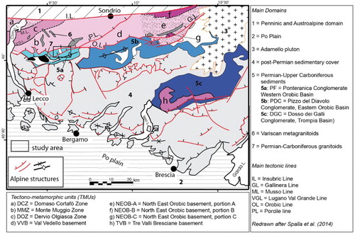
The studied area (about 10 km²) is located in the Western Orobic Alps (Italy), central Southern Alps (). The Orobic Alps are a south-verging polyphase thick-skinned fold-and-thrust belt (CitationBrack, 1981; CitationCarminati, 2009; CitationCastellarin et al., 1992; CitationDe Sitter & De Sitter-Koomans, 1949; CitationForcella, 2004; CitationSchonborn, 1992) developed during Cretaceous–Paleocene oceanic subduction and subsequent continental collision (CitationBernoulli & Winkler, 1990; CitationCarminati, Siletto & Battaglia, 1997; CitationDoglioni & Bosellini, 1987; CitationZanchetta, Garzanti, Doglioni, & Zanchi, 2012; CitationZanchi, Chiesa, & Gillot, 1990). The polyphase Alpine shortening involved the Variscan metamorphic basement (CitationBlom & Passchier, 1997; CitationSiletto, Spalla, Tunesi, Lardeaux, & Colombo, 1993; CitationSpalla & Gosso, 1999) to the north and the Permian–Neogene sedimentary cover, deposited during the Alpine cycle (CitationForcella, 1988), to the south. The stack of thrust sheets is characterized by an E–W trend, a ramp and flat geometry, a southward transport direction and a general lessening of age of both deformation and stratigraphic age toward the south (CitationCarminati & Siletto, 2005; CitationSchonborn, 1992) (see geological inset in the Main Map). The main fault system is the E–W trending Orobic thrust system (CitationAlbini et al., 1994; CitationCarminati et al., 1997; CitationForcella, Jadoul, Bini, & Ferliga, 2000; CitationSiletto, 1990) that leads the overthrusting of a basement slice on the Permian-lower Triassic covers (). The main transport direction is SSE; a dextral component is recorded by CitationSiletto (1991). Cataclasites are associated with thrust faults (CitationAlbini et al., 1994; CitationCarminati & Siletto, 2005; CitationCarminati et al., 1997; CitationCasati & Gnaccolini, 1967; CitationSiletto, 1990; CitationZanchetta, D'Adda, Zanchi, Barberini, & Villa, 2011). 40Ar/39Ar dating on pseudotachylites along the Orobic thrust system, from the Passo San Marco and adjacent areas, fall within two clusters, 80–68 Ma and 59–43 Ma (CitationMeier, 2003; CitationZanchetta et al., 2011), suggesting that segments of the fault system were later reactivated (CitationCarminati & Siletto, 2005). In general, the south-verging movements along the Orobic thrust system started during the eo-alpine phase (late Cretaceous-early Eocene), preceding the intrusion of the Adamello pluton (i.e. pre-Adamello deformation phase) (CitationFantoni, Bersezio, & Forcella, 2004) but remained active until the Adamello intrusion phase and later (CitationZanchetta et al., 2011).
Figure 1. Tectonic sketch map of the Central Southern Alps with the metamorphic evolution recorded in the Variscan basement and in the metamorphic clasts from Lower Permian conglomerates (CitationSpalla & Gosso, 1999; CitationVisscher, 2009; CitationZanoni, Spalla, & Gosso, 2010). The square indicates the study area position.
3. Lithological and stratigraphic data
3.1. Metamorphic basement
The basement is represented by metapelites, quartzites and acid metaintrusives (CitationCarminati et al., 1997). Basement rocks have been mapped on the basis of their structure, mineral composition and abundance. Consequently, micaschists, paragneisses and orthogneisses were distinguished. In particular, the metamorphic basement is characterized by a polyphase evolution developed under evolving metamorphic conditions, from amphibolite-facies conditions, as suggested by relicts of garnet-white mica-biotite marking the oldest fabrics (e.g. S1 foliation), to greenschists-facies conditions. This evolution has been related to the Variscan evolution, as interpreted for similar basement rocks from the Southern Alps (CitationSiletto et al. 1993; CitationSpalla & Gosso, 1999; CitationSpalla et al., 2014).
3.1.1. Micaschists and paragneisses
Micaschists and paragneisses have a similar mineralogical composition, but different mineral percentages. Though different, they have been mapped as a single lithology because of their very frequent alternation and similar structures. Micaschists and paragneiss outcrop N of the Orobic thrust and nearby the Salmurano Pass. The mineralogical composition is: quartz (20–30 vol. %), feldspar (20–30 vol. %), muscovite and biotite (35–55 vol. %), chlorite (5–10 vol. %), rare tourmaline and garnet are present. This mineralogical association is the same for both lithologies, but the percentages change being micas more abundant in micaschists, while quartz and feldspar in paragneisses. Their structure is characterized by spaced foliations from 1 mm to 60–70 mm thick; rootless intrafolial folds occur within the dominant foliation, which is frequently crenulated and a crenulation cleavage may develop, especially in micaschists. The contact between this unit and the sedimentary cover is tectonic.
3.1.2. Orthogneisses
Orthogneisses crop out nearby the Passo San Marco. They have a granodioritic composition (quartz, plagioclase, K-feldspar, biotite, chlorite, epidote); the main fabric is characterized by subhedral grains and inequigranular aggregates; locally, a spaced foliation 1–30 mm thick is present. A mylonitic layer often occurs at the contact between orthogneisses and micaschists and paragneisses.
3.2. Permo-triassic sedimentary cover
The stratigraphic sequence is constituted by a continental volcanic-sedimentary succession (Collio Formation siltstones and Conglomerato del Ponteranica conglomerates and sandstones) and by fluvial conglomeratic-arenaceous deposits (Verrucano Lombardo and Servino formations) (CitationCassinis, Di Stefano, Massari, Neri, & Venturini, 2000; CitationItalian IGCP 203 Group, 1986; CitationPerotti, 1999).
3.2.1. Collio formation
The lower Permian Collio formation (CitationCassinis & Doubinger, 1991; CitationConti, Haubold, Mariotti, & Nicosia, 1997; CitationConti, Mariotti, Mietto, & Nicosia, 1991; CitationVisscher, Kerp, Clement-Westerhof, & Looy, 2001 Citation) is made up of different terrigenous, volcanoclastic and volcanic lithofacies divided into two members (CitationForcella et al., 2000). The lower member, up to 1000 m thick in the central Orobic Alps, is mainly volcanic and volcanoclastic, constituted by riolitic tuff with intercalated terrigenous coarse sediments (CitationForcella et al., 2000). The upper member is mainly terrigenous, constituted by gray siltstones and mudstones with fine intercalations of black pelite and local intercalations of green sandstone, conglomeratic sandstones and conglomerates with greenish matrix. Sandstones have very thin parallel bedding and are composed of volcanic rock fragments, quartz, plagioclase, muscovite and feldspars; matrix is not very abundant (CitationMassari, 2002). The upper member stratigraphic thickness is not known because of the frequent folding and tectonic doublings. The Collio formation outcrops in the western-central part of the area. The Collio formation is heteropic with the Conglomerato del Ponteranica formation (CitationCasati & Gnaccolini, 1965, Citation1967); their contact is not sharp, displaying an irregular trend. The stratigraphic contact with Verrucano Lombardo is represented by an angular unconformity.
3.2.2. Conglomerato del Ponteranica formation
The lower Permian Conglomerato del Ponteranica is constituted by grayish conglomerates with well-rounded clasts, alternated with gray conglomeratic sandstones with rare clasts; the bedding is generally indistinct, locally represented by alternation of conglomeratic and sandy levels. The clasts are volcanic fragments, rare basement fragments and quartz; the sandstones are primarily composed of volcanic fragments, rare quartz, feldspar and muscovite (CitationSciunnach, 2001). The Conglomerato del Ponteranica, up to 520 m thick, has the greatest extension; it crops out in the whole area, except for the Northeastern edge. The stratigraphic contact with the Collio formation is gradual, whereas the contact with the Verrucano Lombardo is clear. The Conglomerato del Ponteranica age is Lower Permian, the same as the Collio formation.
3.2.3. Verrucano Lombardo formation
The upper Permian Verrucano Lombardo is constituted by an alternation of red conglomerates, red sandstones and dark red mudstones; the conglomerate clasts are sub-rounded and rounded quartz fragments and volcanic rocks; the red sandstones are constituted by grains of quartz, volcanic rocks, feldspar and micas (CitationSciunnach, 2001). Verrucano Lombardo, 150–400 m thick, outcrops in the eastern-central part of the area. The Verrucano Lombardo formation age is Upper Permian (CitationMassari & Neri, 1997).
3.2.4. Servino formation
The Servino formation outcrops in two very small areas only, in the eastern part of the study area (Piano dell'Acquanera) and nearby the Ponteranica lakes. The Servino formation age is Lower Triassic (CitationGianotti, Morini, Mottalini, & Santi, 2002). The lower Triassic Formazione del Servino in the Val Brembana area has been divided into two members (CitationForcella et al., 2000). The lower member is composed of yellowish, quartz-rich, coarse to fine sandstones, with rounded grains and ocherous weathering, intercalated by yellow-gray to green shales, marlstones and mudstones; the bedding is parallel with thin layers (CitationGhiselli, Bini, & Zucali, 2005). The upper member is composed of reddish and yellowish siltstones which alternate with dolomite marlstones and green shales (CitationGianotti et al., 2002). Formazione del Servino, 100–130 m thick, outcrops in the northern sector between Pizzo Tre Signori and Mezzoldo and on Monte Torcola.
Formazione Del Servino gradually passes to the Olenekian Carniola di Bovegno represented by vacuolar dolomitic limestone and yellow dolomites with fine clay intercalations, breccias with yellowish carbonatic cement and sharp corner clasts of limestones, dolomites, green shales and polychrome, laminated marls (CitationForcella et al., 2000). Thanks to its mechanical characteristics, Carniola di Bovegno is a preferential decollement horizon (CitationBerra & Siletto, 2006). It outcrops, with a very variable thickness (up to 60–90 m), along thrusts and faults between Monte Ponteranica and Mezzoldo and on the western side of Monte Torcola.
3.3. Quaternary deposits and morphologies
Quaternary deposits are represented by glacial deposits, slope deposits, alluvial deposits, palustrine and peatbog deposits and landslide deposits.
Morphologies have been also mapped: rock glaciers, debris flow, gravitational trenches and moraine ridges.
4. Mesostructural data
4.1. Methodology
Bedding, tectonic foliations, fold axial planes and axes, lineations, faults, displacement markers and fractures have been collected on the field first and then grouped on the basis of their dipping, intersection relationships and kinematic (). Thereafter, they have been analyzed and elaborated in order to reconstruct the relevant chronology of structures ( and Main Map).
Figure 2. (a) Sigmoidal tension gashes in the Verrucano formation; (b) pseudotachylites in basement rocks; (c) shear bends in the Servino formation used as kinematic indicators; (d) folds in basement rocks; (e) slickensides lineations in the Verrucano Formation; (f) cataclastic domains in the Servino formation close to the Orobic thrust.
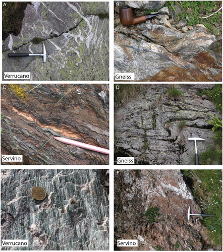
Table 1. Reconstructed main deformation phases and relative mesoscopic structures, for the pre-Alpine and Alpine evolutions at the Passo San Marco – Pizzo di Trona Area.
In the metamorphic basement, foliations and lineations have been distinguished and numbered on the basis of crosscutting relations, kinematic compatibility and mineral associations. Axial fold planes and axes have been mapped and numbered after the fold geometry and the involved surfaces.
In the Permo-Triassic covers, cleavages are more abundant in fine-grained lithologies (e.g. Collio, Servino) rather than in the coarse-grained ones (e.g. conglomerates). They are represented by mm-spaced slaty cleavages () or marked by shape-preferred orientations of clasts. Both foliations and folds are often related to faults.
Faults have been mapped both in the basement and in the sedimentary covers. The kinematic has been recognized after stratigraphic and structural criteria (). The most important and continuous faults have been identified, thanks to the presence and persistence of various thickness cataclastic or mylonitic deformation bands (). The fault movement has been always inferred from displacement markers as elongated quartz, chlorite fibers, and striae. For each fault, the azimuth of the slickenside lineation is indicated on the map, next to the fault plane dip, in brackets: for faults with unknown kinematic, the azimuth value indicates one of the two possible slip directions; for the other faults, two azimuth values indicate two different slip directions along the same fault plane, thus indicating the reactivation of the fault plane.
The analysis of structural data has enabled six groups of structures, belonging to six different deformation phases, to be separated (). The first three phases are pre-Alpine and were recorded in the metamorphic basement only; the other three phases are Alpine and were recorded both in the basement and in the sedimentary covers. In particular, five fault systems were separated at the macroscale: the A, B, C, D, E systems.
5. Results
The D1–D3 deformation phases are recorded only in the metamorphic basement since they belong to the pre-alpine cycle.
5.1. D1
D1 is characterized by a composite S1 foliation marked by thin quartz–feldspar layers alternate to phyllosilicate-rich layers. The orientation of the S1 foliation may vary, due to pre-alpine and alpine folding and thrusting. Orthogneisses may produce strongly lineated to foliate fabrics during the D1 deformation; lineation and foliation are marked by highly strained feldspar crystals or aggregates and biotite + white mica-rich layers. Commonly, the S1 foliation and lineation are marked by white mica and biotite and by the preferred orientation of quartz- and feldspar-rich layers.
5.2. D2
D2 is mainly related to meter- to decameter-scale folding of the S1 fabrics; axial plane ((d)) may also vary in attitude due to successive crenulation and faulting. An S2 foliation may also occur and it is marked by white mica and chlorite-preferred orientation and by elongation of quartz layers and rods.
5.3. D3
D3 commonly occurs as meter-scale crenulations that also affect the large-scale fabric orientations, producing a dispersion of D2 axial planes and axes. Locally, an S3 crenulation cleavage may develop.
5.4. D4
D4 is commonly associated with folding and thrusting in cover units and basements. In particular, basement rocks are characterized by localized deformation bands, as cataclasites and pseudotachylites ((b)), while in cover units, various types of structures may occur (). Faults and tension gashes are widespread in the Verrucano Lombardo and conglomerates ((a) and 2(e)), while the Servino more diffusely records D4 as cataclasites ((c)), S4 cleavage ((f)) and folds. Thrusts faults, dipping NNW (A-system), define the most prominent structure in the area, which can be easily related to the Orobic thrust system, but oblique (B-system, reverse-left) faults dipping NW or SE and left strike-slip faults, dipping W or SW, also occur.
5.5. D5
D5 deformation occurs as strike-slip faults, sinistral (NNW dipping) and destral (ESE dipping), affecting the Permo-Triassic cover (C-system).
5.6. D6
D6 deformation is defined by a system of reverse S dipping faults (D-system) and normal faults, dipping NNW (E-system).
6. Conclusions
The detailed structural and geomorphological mapping led to the editing of the presented map and to the collection of a strong structural dataset of the Passo San Marco – Pizzo di Trona area. The particular attention paid to brittle structures, not reported from previous authors, allowed us to distinguish the pre-Alpine ductile phases from the Alpine, mainly brittle, deformation phases. The reconstruction of the deformation chronology, together with the geomorphological evolution, was then integrated in the regional geological setting, giving a contribution to the understanding of the deformation and geomorphological evolution of this sector of the Southalpine domain.
Software
The dataset collected on the field was reported in an Excel (CitationMicrosoft, 2003) database and then imported in ArcMap (CitationESRI, 2011). The map elements were drawn with ArcMap (CitationESRI, 2011), while the sections with Corel Draw (CitationCorelDraw, 2005). Stereographic projections were performed using the software FSA (CitationCelerier, 2013) and OSXStereonet (CitationCardozo & Allmendinger, 2013). The map layout was edited using ArcMap (CitationESRI, 2011).
STRUCTURAL GEOLOGICAL AND GEOMORPHOLOGICAL MAP OF THE PASSO SAN MARCO - PIZZO DI TRONA AREA (WESTERN OROBIC ALPS, SOUTHERN ALPS, ITALY)
Download PDF (18 MB)Acknowledgement
This work is part of two Graduate Theses and of a PhD Thesis.
Funding
This work is funded by the Department of Earth Sciences (Università degli Studi di Milano).
Related Research Data
References
- Albini, S., Battaglia, D., Bellini, G., Bigoni, C., Carminati, E., Ceriani, S., … Spalla, M. I. (1994). Alpine deformations and pre-Alpine remnants in the north-eastern Orobic Alps, Southalpine Belt. In A. Montrasio & E. Sciesa (Eds.), Proceedings of the symposium ‘CROP – Alpi Centrali’ (Vol. 2, pp. 25–39). Milan: Consiglio Nazionale della Ricerche, Centro Nazionale delle Ricerche.
- Bernoulli, D., & Winkler, W. (1990). Heavy mineral assemblages from Upper Cretaceous South- and Austroalpine Flysch sequences (Northern Italy and Southern Switzerland): Source terrains and palaeotectonic implications. Eclogae Geologicae Helvetiae, 83, 287–310.
- Berra, F., & Siletto, G. B. (2006). Controllo litologico e stratigrafico sull'assetto strutturale delle Alpi meridionali lombarde: il ruolo degli orizzonti di scollamento. Rendiconti della Società Geologica Italiana, 2, 78–80.
- Blom, J. C., & Passchier, C. W. (1997). Structures along the Orobic thrust, Central Orobic Alps, Italy. Geologische Rundschau, 86(3), 627–636. doi: 10.1007/s005310050168
- Brack, P. (1981). Structures in the southwestern border of the Adamello intrusion (Alpi Bresciane). Schweizerische Mineralogische und Petrographische Mitteilungen, 61, 37–50.
- Cardozo, N., & Allmendinger, R. W. (2013). Spherical projections with OSXStereonet. Computers & Geosciences, 51, 193–205. doi: 10.1016/j.cageo.2012.07.021
- Carminati, E. (2009). Neglected basement ductile deformation in balanced-section restoration: An example from the Central Southern Alps (Northern Italy). Tectonophyiscs, 463, 161–166. doi: 10.1016/j.tecto.2008.09.042
- Carminati, E., & Siletto, G. B. (2005). The Central Southern Alps (N Italy) paleoseismic zone: A comparison between field observations and predictions of fault mechanics. Tectonophyiscs, 401, 179–197. doi: 10.1016/j.tecto.2005.03.012
- Carminati, E., Siletto, G. B., & Battaglia, D. (1997). Thrust kinematics and internal deformation in basement involved foreland fold and thrust belts: The Eastern Orobic Alps case (Central Southern Alps, Northern Italy). Tectonics, 16, 259–271. doi: 10.1029/96TC03936
- Casati, P., & Gnaccolini, M. (1965). Una nuova formazione paleozoica dell'alta Val Brembana: la Formazione di Ponteranica. Rivista Italiana di Paleontologia e Stratigrafia, 70, 791–804.
- Casati, P., & Gnaccolini, M. (1967). La geologia delle Alpi Orobie Occidentali. Rivista Italiana di Paleontologia e Stratigrafia, 73, 25–162.
- Cassinis, G., Di Stefano, P., Massari, F., Neri, C., & Venturini, C. (2000). Permian of South Europe and its interregional correlations. In H. Yin, J. M. Dickins, G. R. Shi, & J. Tong (Eds.), Permian-Triassic evolution of Tethys and Western Circum-Pacific (pp. 37–70). Amsterdam: Elsevier Science.
- Cassinis, G., & Doubinger, J. (1991). On the geological time of the typical Collio and Tregiovo continental beds in the Southalpine Permian (Italy), and some additional observations. Atti Ticinesi di Scienze della Terra, 34, 1–20.
- Castellarin, A., Cantelli, L., Fesce, A. M., Mercier, J. L., Picotti, V., Pini, G. A., … Selli, L. (1992). Alpine compressional tectonics in the Southern Alps. Relationships with the N-Appennines. Annales Tectonicae, 6, 62–94.
- Celerier, B. (2013). FSA: Fault & stress analysis software (Version 35.1). Retrieved 2 June 2013, from http://www.pages-perso-bernard-celerier.univ-montp2.fr/software/dcmt/fsa/fsa.html
- Conti, M. A., Haubold, H., Mariotti, N., & Nicosia, U. (1997). The footprint fauna of the ‘Collio’ and the meaning of ‘Anhomoiichnium’. In H. Haubold (Ed.), Workshop on: ‘Ichnofacies and ichnotaxonomy of the terrestrial Permian’, Halle, Germany (pp. 8–12).
- Conti, M. A., Mariotti, N., Mietto, P., & Nicosia, U. (1991). Nuove ricerche sugli icnofossili della Formazione di Collio in Val Trompia (Brescia). Natura Bresciana Annales Museo Civico di Storia Naturale di Brescia, 26, 109–119.
- CorelDraw. (2005). CorelDraw Graphic Suite. Ottawa, Canada: Corel Corporation of Ottawa.
- De Sitter, L. U., & De Sitter-Koomans, C. M. (1949). Geology of the Bergamasc Alps, Lombardia, Italy. Leidse Geologische Mededelingen, 14, 1–257.
- Doglioni, C., & Bosellini, A. (1987). Eoalpine and Mesoalpine tectonics in the Southern Alps. Geologische Rundschau, 76, 735–754. doi: 10.1007/BF01821061
- ESRI. (2011). ArcGIS Desktop: Release 10. Redlands, CA: Environmental Systems Research Institute.
- Fantoni, R., Bersezio, R., & Forcella, F. (2004). Alpine structure and deformation chronology at the Southern Alps-Po Plain border in Lombardy. Bollettino della Soceità Geologica Italiana, 123, 463–476.
- Forcella, F. (1988). Assetto strutturale delle Orobie orientali tra la Val Seriana e la Val Camonica. Rendiconti della Societa Geologica Italiana, 11, 269–278.
- Forcella, F., Jadoul, F., Bini, A., & Ferliga, C. (2000). Note illustrative della Carta geologica della Provincia di Bergamo alla scala 1:50.000. Eds: Servizio Territorio della Provincia di Bergamo, Dipartimento di Scienze della Terra dell'Università degli Studi di Milano, Centro di Studio per la Geodinamica Alpina e Quaternaria del CNR.
- Gianotti, R., Morini, S., Mottalini, G., & Santi, G. (2002). La successione permiana e triassica tra la Valle di Pescegallo ed il lago Valmora (Lombardia, Bacino Orobico). Stratigrafia e paleontologia. Atti Ticinesi di Scienze della Terra, 43, 55–72.
- Ghiselli, A., Bini, A., & Zucali, M. (2005). Structural analysis of roches moutonnées in Western Orobic Alps (Lombardia). Geografia fisica e dinamica quaternaria. Supplementi, 7, 163–177.
- Italian IGCP 203 Group. (1986). Field guide-book of Permian and Permian-Triassic boundary in the South-Alpine segment of the western Tethys (Proj. n.203). Brescia: SGI, 180 pp.
- Massari, F., & Neri, C. (1997). The infill of a supradetachment (?) basin: The continental to shallow-marine Upper Permian succession in the Dolomites and Carnia (Italy). Sedimentary Geology, 110(3–4), 181–221. doi: 10.1016/S0037-0738(96)00084-X
- Meier, A. (2003). The Periadriatic fault system in Valtellina (N-Italy) and the evolution of the southwestern segment of the Eastern Alps. (PhD Dissertation). ETH Zurich, no. 15008, 190 pp.
- Microsoft. (2003). Microsoft Excel. Redmond, WA: Computer Software.
- Perotti, C. R. (1999, September 15–25). Permian tectonics in the Central Southern Alps. In Cassinis, G., Cortesogno, L., Gaggero, L., Massari, F., Neri, C., Nicosia, U., & Pittau, U. (coord.), Stratigraphy and facies of Permian deposits between eastern Lombardy and the western Dolomites. Field Trip Guidebook, International Congress on: ‘The Continental Permian of the Southern Alps and Sardinia (Italy). Regional Reports and General Correlations’, Brescia, pp. 19–20.
- Schonborn, G. (1992). Alpine tectonics and kinematic models of the Central Southern Alps. Memorie di Scienze Geologiche, 44, 1–390.
- Sciunnach, D. (2001). The lower Permian in the orobic Anticline (Southern Alps, Lombardy): a review based on new stratigraphic and petrographic data. Rivista Italiana di Paleontologia e Stratigrafia, 107-1, 47–68.
- Siletto, G. B. (1990). Polyphase tectonics in the Orobic basement of Passo S.Marco (Upper Val Brembana, Southern Alps, Italy). Memorie della Società Geologica Italiana, 45, 101–105.
- Siletto, G. B. (1991). Cronologia relativa dei sovrascorrimenti in aree selezionate del basamento Orobico. (Tesi di Dottorato). Univeristà degli Studi di Milano, 145 pp.
- Siletto, G. B., Spalla, M. I., Tunesi, A., Lardeaux, J. M., & Colombo, A. (1993). Pre-Alpine structural and metamorphic histories in the Orobic Southern Alps, Italy. In J. F. von Rumer & F. Neubauer (Eds.), Pre-Mesozoic geology in the Alps (pp. 585–598). Heidelberg: Springer-Verlag.
- Spalla, M. I., & Gosso, G. (1999). Pre-Alpine tectonometamorphic units in the central southern Alps; structural and metamorphic memory. In G. Gosso, F. Jadoul, M. Sella, & I. Spalla Maria (Eds.), 3rd workshop on Alpine geological studies, 51(1), 221–229.
- Spalla, M. I., Zanoni, D., Gosso, G., & Zucali, M. (2009). Deciphering the geologic memory of a Permian conglomerate of the Southern Alps by pebble P–T estimates. International Journal of Earth Sciences, 98(1), 203–226. doi: 10.1007/s00531-007-0241-8
- Spalla, M. I., Zanoni, D., Marotta, A. M., Rebay, G., Roda, M., Zucali, M., & Gosso, G. (2014). The transition from Variscan collision to continental break-up in the Alps: Insights from the comparison between natural data and numerical model predictions. Variscan orogeny: Extent, timescale and the formation of the European Crust: Geological Society, London, Special Publications 405, SP405. 11.363–400.
- Visscher, H., Kerp, H., Clement-Westerhof, J. A., & Looy, C. V. (2001). Permian floras of the Southern Alps. Natura Bresciana, 25, 117–123.
- Zanchetta, S., D'Adda, P., Zanchi, A., Barberini, V., & Villa, I. M. (2011). Cretaceous-eocene compression in the central Southern Alps (N Italy) inferred from 40Ar/39Ar dating of pseudotachylytes along regional thrust faults. Journal of Geodynamics, 51(4), 245–263. doi: 10.1016/j.jog.2010.09.004
- Zanchetta, S., Garzanti, E., Doglioni, C., & Zanchi, A. (2012). The Alps in the cretaceous: A doubly vergent pre-collisional orogen. Terra Nova, 24(5), 351–356. doi: 10.1111/j.1365-3121.2012.01071.x
- Zanchi, A., Chiesa, S., & Gillot, P. Y. (1990). Tectonic evolution of the Southern Alps in the Orobic chain: Structural and geochronological indications for pre-tertiary compressive tectonics. Memorie della Societa Geologica Italiana, 45, 77–82.
- Zanoni, D., Spalla, M. I., & Gosso, G. (2010). Structure and PT estimates across late-collisional plutons: Constraints on the exhumation of western Alpine continental HP units. International Geology Review, 52(10–12), 1244–1267. doi: 10.1080/00206814.2010.482357