
Abstract
This paper presents a geomorphological map of the Hérens valley in the Western Swiss Alps. With an area of 270 km2 and altitudes ranging from 470 to 4357 m a.s.l., this valley is one of the main secondary catchments of the Upper Rhône valley. The high differences in altitudes, combined with a varied geology, create an important geomorphic diversity. The main processes active in mountain areas, that is, glacial, periglacial, gravitational and fluvial processes, are well represented. The map was produced in ArcGIS using a specific legend developed at the University of Lausanne.
1. Introduction
Climatic evolution since the end of the last glaciation has resulted in a major impact on the activity of geomorphic processes in mountain areas. At low elevations, most landforms are relict or inherited from formerly active processes, whilst at higher elevations the combination of cold temperatures and steeper slopes generally provokes a stronger process activity. This is enhanced by the current climate warming, which induces rapid evolution of the landscapes resulting in accelerated glacier melting and increasing sediment delivery due to permafrost degradation (CitationHarris et al., 2003; CitationHuggel et al., 2010; CitationPaul, Kääb, & Haeberli, 2007). The result is a strong diversity of landforms present in mountain areas like the Alps, both in terms of morphogenesis and morphodynamics. Geomorphological mapping in Alpine environments aims at reporting this diversity on a map (CitationDramis, Guida, & Cestari, 2011). According to the objectives, the focus can be placed on the morphogenesis of the landforms (morphogenetic maps; e.g. CitationOndicol, 2009) or on the process activity (morphodynamic maps; e.g. CitationTheler & Reynard, 2011). In both cases, the resulting map offers an overview of the processes that have had the strongest influence on the morphological evolution of the landscape. These data can then be used, for instance, as a basis for hazard maps (CitationHearn & Hart, 2011), for sediment budget assessment (CitationOtto & Dikau, 2004) or for geomorphosite mapping (CitationSerrano & Gonzalez-Trueba, 2005).
Whereas topographical and geological maps have had substantial development for several decades, the production of geomorphological maps has remained limited in Switzerland despite the large number of geomorphological studies carried out in the Swiss Alps. In the 1940s, the Swiss Geomorphological Society developed a mapping system that differentiated sedimentary and erosional landforms, and some maps were produced using this mapping system until the 1970s (see CitationSchoeneich, 1993 for a review). Examples of Swiss geomorphological maps produced with other mapping systems can be found in CitationSchoeneich (1998), CitationOtto and Dikau (2004) and CitationLambiel, Bardou, Delaloye, Schuetz, and Schoeneich (2009).
The Hérens valley (Western Swiss Alps; ) has had a large number of geomorphological studies. Located on the orographic left side of the Rhône River in the Valais Alps, this valley is one of the largest secondary catchments of the Upper Rhône valley. Thanks to the geological and geomorphological diversity, it has attracted a number of international scientists from various geoscience-related disciplines for several decades. In particular, easy access to glaciers has facilitated a large number of glaciological studies (e.g. CitationMair, Nienow, Willis, & Sharp, 2001; CitationSharp et al., 1993; CitationWillis et al., 2003), with studies on glacial deposit also numerous. The glacial stages of the valley were first studied by CitationWinistörfer (1977) and more recently by CitationScapozza (2013). The moraine genesis of several glaciers was investigated by CitationSchneebeli and Röthlisberger (1976), whilst the paraglacial evolution of Little Ice Age (LIA) moraines was studied by CitationCurry, Cleasby, and Zukowskyj (2006). The periglacial geomorphology has primarily been investigated in the Arolla valley (). CitationGardaz (1997) studied the distribution of mountain permafrost in the Fontanesses area. A focus on permafrost occurrence within talus slopes of the region was made by CitationDelaloye and Lambiel (2005), CitationLambiel and Pieracci (2008) and CitationScapozza, Lambiel, Baron, Marescot, and Reynard (2011). Research on rock glaciers was carried out by CitationLambiel, Delaloye, Strozzi, Lugon, and Raetzo (2008). More generally, the detection and mapping of slope movements in the periglacial belt of the valley with differential interferometric synthetic aperture radar (DInSAR) were proposed by CitationBarboux, Delaloye, and Lambiel (2014). Several fluvial geomorphology studies have also been carried out in the valley (e.g. CitationLane, Bakker, Balin, Lovis, & Regamey, 2014; CitationLane, Richards, & Chandler, 1996; CitationSmall, 1973; CitationWarburton, 1990). Finally, an integrated analysis of the mountain system was recently proposed by CitationReynard, Lambiel, and Lane (2012).
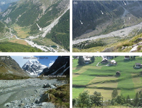
Figure 1. Location of the Hérens valley. The corners and white dots indicate the location of the photos; the numbers refer to the figure numbers. © [Swisstopo]. Reproduced with the permission of swisstopo (BA13064).
![Figure 1. Location of the Hérens valley. The corners and white dots indicate the location of the photos; the numbers refer to the figure numbers. © [Swisstopo]. Reproduced with the permission of swisstopo (BA13064).](/cms/asset/079400e9-1afd-4bb8-8a59-1569614fdc63/tjom_a_999135_f0001_b.gif)
However, no global overview on the geomorphic diversity of the valley exists. To fill this gap, a map of the entire Hérens valley (Main Map) was produced within the framework of a project aiming at studying the torrent activity of the catchment (CitationMaillard, Theler, & Reynard, 2013a, Citation2013b). The map was produced using the morphogenetic legend of the University of Lausanne, which has recently been adapted for Esri ArcGIS. After presenting the geographical, geological and morphological setting of the valley, we go on to detail the legend used. The geomorphological analysis is then presented following the main process types. To find the sites named in the analysis on the map, we recommend using the swisstopo geodatabase website (www.map.geo.admin.ch).
2. Geographical, geological and climatic setting
The Hérens valley is a south–north catchment located on the orographic left side of the Rhône River (Swiss Alps) (). It is 30 km in length, with an area of around 270 km2 and altitudes ranging between 470 and 4357 m a.s.l. (Dent Blanche). Along the valley, the vertical slope extent ranges between around 1500 and 2000 m. The catchment is divided into two main valleys just north of the village of Euseigne, at 710 m a.s.l.: the Hérémence valley to the west and the Hérens valley strictly speaking to the east. A second division occurs in Les Haudères, at 1420 m a.s.l., with the Arolla valley to the west and the Ferpècle valley to the east.
The geology of the valley exerts a strong control on the topography and the geomorphology. From north to south, four main alpine units succeed (CitationSteck, Epard, Escher, Gouffon, & Masson, 2001) (). The Siviez-Mischabel and Mont Fort nappes belong to the Middle Penninic and are present in the northern part of the area. The main rocks forming these units are schistous quartzites, micaschists, gneisses and amphibolites. The upper slopes of the right side of the valley, to the east of Saint-Martin, are made of Permo-Trias quartzites ((a)). The crest that dominates these slopes belongs to the Tsaté nappe, which is mainly built of oceanic sediments. The majority of the rocks are calcschists, but prasinites (metabasalts) and serpentinites from the oceanic crust are also locally present. This geology offers the smoothest slope and best expressed on the southwest facing slopes dominating Evolène, at the top of which rock walls are almost absent ((b)). This landscape contrasts strongly with the much steeper slopes and high rock walls located in the southern part of the valley (). This sector belongs to the Dent Blanche nappe (Australpine unit) and is composed mainly of orthogneisses of the Arolla series (Arolla gneiss). However, metagabbros and breccias are also present in the Arolla valley. The first constitute the emblematic Mont Collon, whereas the second ones are found in the Mont Dolin area.
Figure 2. Geological sketch of the Hérens valley.
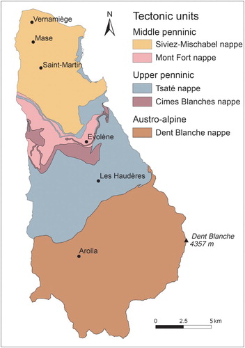
Figure 3. (a) Typical landscape at the north-east of St-Martin, with relict rock glaciers at the foot of quartzitic talus slopes. Processes are generally low or no longer active. (b) The smooth slopes dominating Evolène, made with calcschists of the Tsaté nappe.
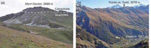
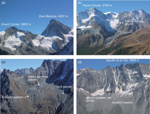
Figure 4. The large rock faces dominating the glacial and periglacial landscapes in the Dent Blanche nappe sector (the southern part of the Hérens valley). (a) Grand Cornier and Dent Blanche, with the Bricola and Dent Blanche glaciers (Ferpècle catchment). (b) Pigne d'Arolla and Tsijiore Nouve glacier, above Arolla. (c) The Tsarmine sector, with its debris-covered glacier and the large associated Holocene moraine deposits and the active Tsarmine rock glacier (Arolla catchment). (d) The debris-covered La Tsa glacier and its thick Holocene moraine deposits (east of Arolla).
Due to its position in the central part of the Alps, the Hérens valley is sheltered from the main atmospheric disturbances. As a consequence, the climate of the valley is relatively dry, with a mean annual precipitation of 720 mm (mean 1987–2012) at the Evolène-Villa climatic station (1825 m a.s.l.). The 0°C isotherm is around 2600 m a.s.l.
3. Methods
The map was designed using the geomorphological mapping legend of the University of Lausanne (CitationSchoeneich, 1993). This legend is a morphogenetic mapping system built on the following principles:
colours represent process categories;
symbols have a genetic significance and are drawn in the colour of the related process;
morphodynamic differentiation of erosion and accumulation areas is achieved by white and coloured surfaces, respectively;
morphography, slope gradient and lithology are not represented and are intended to be present in the basemap used. The legend can also be used with other base layers (e.g. Digital Elevation Models, orthophotos).
The legend has been used for detailed mapping (scale 1:10,000) for more than 20 years, especially in high- and mid-altitude mountain regions (CitationOndicol, 2009; CitationSchoeneich, 1993; CitationSchoeneich, Reynard, & Pierrehumbert, 1998). It was first developed for mapping by hand with colour pencils in the field. In the 1990s, several attempts were made to develop computer-assisted maps, particularly using Adobe Illustrator (e.g. CitationSchoeneich, 1998; CitationSchoeneich et al., 1998). Improvement in the graphical performance of geographic information system (GIS) has permitted the adaptation of the legend for GIS with a new version developed for Esri ArcGIS 10.0. The legend consists of a geodatabase containing three Feature Datasets, which contain, respectively, the Feature Classes ‘points', ‘lines' and ‘surfaces'. Specific symbols were developed using the Representation tool in ArcGIS 10.0. For some landforms (e.g. alluvial fans, rock glaciers, deltas), it was necessary to combine two or three point, line or surface symbols. When using the legend, the selection of the symbol must be done before drawing, so that the landform appears directly with the right symbol. This provides a high ease of use. The legend can be downloaded from the Institute of Geography and Sustainability, University of Lausanne (www.unil.ch/igul/legende_UNIL).
The advantages of mapping the geomorphology in ArcGIS are numerous. Analysis tools can be used, for example, to calculate areas of specific landform categories. Being part of a GIS project, the map represents one layer among others, such as basemaps (topographic map, digital elevation model, orthophotos, etc.), a hazard map, an inventory of slope movements, etc. Map updates can then be easily completed from new orthophotos.
In this project, the geomorphic analysis and mapping were carried out directly on the computer. The data used were (1) topographic maps (scale 1:25,000); (2) orthophotos from different years; (3) the SwissAlti3D digital elevation model of Swisstopo, with a resolution of 50 cm below 2000 m a.s.l. and 2 m above 2000 m a.s.l. and (4) various DInSAR data. Several unpublished geomorphological maps of the area were also used as a basemap. In the northern part of the valley, the geomorphological mapping was difficult because of the forests that cover a large part of the slopes and so we made use of the Geological Atlas of Switzerland (1:25,000). Field verification was also performed. We chose the black and white Swiss National Map (1:25,000) for the topographic background. This corresponds to the mapping choice made for the Geological Atlas of Switzerland.
4. Geomorphic analysis
4.1. Erosional and depositional areas
The legend system used allows efficient distinction between erosional and depositional landforms. For the 270 km2 of the valley area, 184 km2 correspond to deposits, with the remaining areas erosional (46 km2) and glaciers (40 km2). Whilst the valley has been deeply shaped by active glacial erosion during the Pleistocene, erosional areas have been actively modified by gravitational and fluvial processes and by moraine deposits from Lateglacial stages. These deposits have then been partially eroded by gravitational and torrent processes near the valley bottom in the northern part of the valley.
Other main erosional areas correspond to high rock walls made of orthogneisses of the Dent Blanche nappe in the southern part of the valley (). Roche moutonnée outcrops and large landslide scarps are the other main erosional landforms. Smaller erosional sectors, such as the internal part of LIA moraines affected by paraglacial reworking, were not systematically mapped, due to the basemap scale. Thus erosional areas may be slightly underestimated.
The largest depositional sectors correspond to glacial deposits from the last glaciation (i.e. the Würm) and from early Lateglacial stages. On the orographic right side of the valley, north of Evolène, these deposits were often remobilized by landslides or deep-seated gravitational slope deformations (DSGSDs), which are often no longer active today. In the southern half of the valley, due to higher elevations and steeper slopes, the processes are generally still active, such as glacial and periglacial processes ().
4.2. Glacial landforms
The relative dryness of the climate currently maintains the equilibrium line of glaciers at elevations generally higher than 3000 m a.s.l. However, due to the high elevations, several large glaciers are still present, as, for instance, the Ferpècle and Mont Miné glaciers in the Ferpècle catchment ((a)) and the Haut and Bas glaciers d'Arolla and the Tsijiore Nouve glacier ((b)) in the Arolla catchment. During the Pleistocene glaciations, all these glaciers were joined together to form the Hérens glacier, which was connected to the Rhône glacier at the valley outlet. Glacial erosion landforms are mainly visible on the orthogneisses in the southern part of the valley. Large outcrops of roches moutonnées are present on the right side of the Arolla valley and on the steep slopes of the Ferpècle valley. Particularly remarkable is the Ferpècle glacier forefield, with glacial holes and Nye channels ((b)).
Figure 5. (a) Mont Miné glacier and glacier forefield (Ferpècle valley; photo 2004). The arrow indicates the location of the Nye channels depicted in (b).
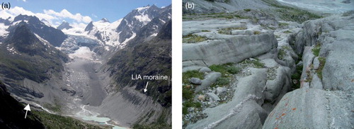
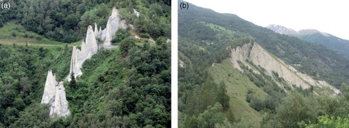
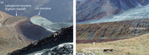
Looking at the map, the influence of glacial processes on valley development is firstly visible through the large extent of moraine deposits on the valley flanks. The Euseigne Pyramids are emblematic landforms resulting from the erosion of a Lateglacial moraine built by the neighbouring Dix glacier ((a)). The La Luette moraine complex is another well-defined Lateglacial stadial in the valley ((b)). Above the villages of Mase and St-Martin, several morainic crests dating from old Lateglacial stages are present, however with a reduced size. It is also possible that many crests were partly eroded or even destroyed by gravitational processes (landslides). In the Ferpècle and Arolla catchments, Lateglacial deposits are rather rare, due to the steep valley flanks, which prevent landform preservation. Exceptions are the well-preserved moraine dating back probably to the Younger Dryas (Egesen stadial) on the orographic left side of the Tsijiore Nouve glacier (CitationScapozza, 2013; CitationSchneebeli & Röthlisberger, 1976) ((b) and 7(a)), and the complex Lateglacial morainic system of the Lac Bleu area, on the orographic left side of the Arolla catchment (CitationKummert, 2012)
Figure 6. (a) Euseigne Pyramids and (b) La Luette morainic complex.
Since the end of the LIA, all the glaciers have undergone severe retreat. Consecutive large proglacial margins have appeared, such as in front of the Ferpècle, Mont Miné and Arolla glaciers ((a)). In these cases, however, lateral moraines could only accrete against the valley side due to very steep lateral slopes. Accordingly, the lateral moraines are not that large, despite the large basin area and high rock walls, but they clearly delineate the LIA extension. The tongue of the Tsijiore Nouve glacier extended into a large open space, which allowed the formation of very large lateral moraines (). LIA glacial deposits are also voluminous in the front of smaller glaciers located in the Ferpècle and Arolla catchments. These glaciers often developed at the foot of high rock walls. During cold periods of the Holocene, they conveyed large amounts of debris to the top of steeper slopes, building voluminous morainic bastions, best exemplified by the Tsarmine ((c)), and La Tsa glaciers ((d)).
Figure 7. Left lateral moraines of the Tsijiore Nouve glacier. (a) Lateglacial (Egesen stadial) and LIA moraines. (b) Solifluction on the LIA moraine.
4.3. Gravitational landforms
In its northern part, the right side of the valley is affected by several DSGSDs and landslides in the morainic deposits. Some are still active, whereas others are relict. Most of them are a result of the glacial decompression that followed the retreat of the Hérens glacier. DSGSDs also affect the steeper slopes located south of the valley, particularly on the right side of the Arolla valley, with sometimes strong dislocations ( (a) and (b)).
Figure 8. Dislocated DSGSDs on the right side of the Arolla catchment. The arrows show the upper limit of the landslides. On (a) the fresh scarps indicate the high activity of the landslide, amplified by the lateral erosion by debris flows.
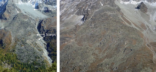
Talus slopes form the other main gravitational landform group in the valley. They are present in the entire study area, but are particularly widespread in the Dent Blanche nappe, at the foot of the high orthogneiss walls. Some of them can reach vertical extents of 400 m ((a) and 9(a) and (b)). Together, with intense gelifraction at high elevations, the high relief energy, especially in the southern part of the valley, is responsible for very active rock fall activity.
4.4. Periglacial landforms
The lower limit of discontinuous permafrost in this part of the Alps is roughly between 2400 m a.s.l. on north slopes and 2700 m a.s.l. on south slopes (CitationLambiel & Reynard, 2003). In the northern part of the valley, most rock glaciers are located at lower elevations. They formed during the Lateglacial period and are currently relict. Some of them reach very large dimensions, such as those located on the western flanks of the Sasseneire ((b)). The role of glacial processes in landform development in this sector is suggested by the presence of angular crests on some rock glaciers, which may be interpreted as morainic crests.
Figure 9. Gravitational and periglacial landforms in the Hérens valley. (a) Talus slopes and rock glaciers in the Fontanesses catchment (Arolla). a, active rock glacier, i, inactive rock glaciers, r, relict rock glaciers. (b) The large A-Vieille relict rock glacier, made of calcschists of the Sasseneire. (c) La Roussette active rock glacier (east of Arolla). (d) The large inactive rock glacier of Liapey d'Enfer.
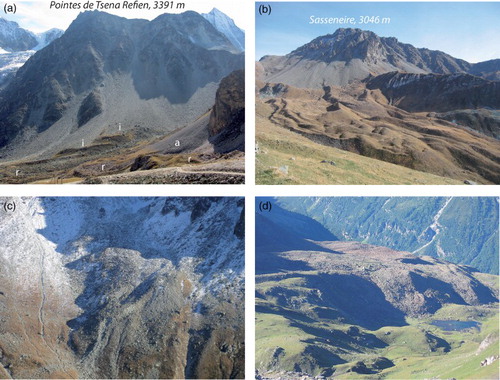
Where the lithology is dominated by calcschists (i.e. Tsaté nappe), the availability of loose debris is reduced, due to the moderate extent of rock walls ((b)). As a consequence, rock glaciers are rare. On the other hand, where rock walls are well developed, typically in the southern part of the valley (Dent Blanche nappe), rock glaciers are much more developed, due to the large sedimentary stock. The limiting factors for their occurrence are the steep slopes and the presence of glaciers. However, the dry climate reduces glacier size and, thus, the vertical extent of the periglacial belt is relatively high. Overall, rock glaciers are widespread in this region. The most significant ones are found on the right side of the Arolla valley ((c) and 9(c)) or east of La Forclaz ((d)). Some large relict landforms are also present west of Arolla, in the Mont Dolin sector.
Solifluction landforms are also widespread in the valley, especially in the slopes made up of calcschists, such as, for instance, the northwest facing talus slopes located west of Palanche de la Cretta. Numerous LIA moraines, like those of the Tsijiore Nouve glacier ((b)), have also been remobilized by solifluction. The process is no longer active in some areas, typically on the slopes that dominate Evolène, where large sectors of relict solifluction landforms are present.
4.5. Fluvial landforms
Torrent activity in the valley is important, with the most active watersheds located in the southern part of the valley, where the slopes are steepest. In particular, the most intense activity is found in the interfluve between the Arolla and Ferpècle valleys. In this area, torrent fans are widespread, as illustrated by the Satarma fan ((a)). Watersheds with regular torrent activity are also found on the eastern slopes of Mont de l'Etoile and on the south-western slopes of Sasseneire.
Figure 10. Fluvial landforms in the Hérens valley. (a) The torrential fan at Satarma (Arolla catchment). (b) The braided course of the Borgne d'Arolla River, in the proglacial margin of the Bas Glacier d'Arolla. The arrows show the LIA right lateral moraine. f, torrential fan. (c) Closer view of the Borgne d'Arolla River. (d) Alluvial terraces in Les Haudères.
Alluvial deposits along the Borgne River are relatively rare because of the V-shaped form of the valley. However, two sectors with substantial deposits exist, in the Arolla valley and lower down in the Les Haudères area. In the first location, the frequent extraction of water for hydroelectric power production results in a decrease in the sediment transport capacity of the river and a consequent increase in sediment deposition (CitationLane et al., 2014). This results in a dynamic braided system ((b and c)). In the Les Haudères area, the Holocene history of fluvial deposition and erosion phases has built several well-preserved terrace levels ((d)).
5. Conclusion
Thanks to various lithologies and large differences in altitudes (around 4000 m), the Hérens valley presents high geomorphic diversity, particularly between the lower and smoother northern part and the southern part featuring high and steep rock walls. As illustrated by the map, glacial processes have had the most significant impact on the morphogenesis of the valley. However, well-preserved Lateglacial moraines are rather rare, because of the steep slopes and reduced space in the valley bottom. The most significant moraine deposits are often present under the form of thick Holocene morainic bastions at the front of small cirque glaciers. Gravitational landforms also occupy large areas, and whilst they often correspond to old landslides in the northern half of the valley, they are made up of active talus slopes in the upper part of the catchment. The main periglacial landforms are rock glaciers, which are generally large and relict in the northern part of the valley. Several active rock glaciers are found in the southern part, in catchments not occupied by large glaciers. Finally, fluvial processes are the fourth main process active in the Hérens valley. They have built numerous torrent fans, particularly in the Arolla and Ferpècle catchments.
The map produced offers a good overview of the geomorphic diversity of the valley. Both morphogenesis and erosional/depositional areas can be quickly identified, thanks to the legend used. In the end, the map can be used as a basis for palaeogeographic studies, for geomorphosite inventories, for geotourism-related activities, for sediment budget and natural hazard studies or for landscape planning. It also offers a complement to geological maps.
Software
The map was created using Esri ArcGIS 10.1, with final editing carried out with Adobe Illustrator.
Geomorphological map of the Hérens Valley (Swiss Alps)
Download PDF (17.1 MB)Acknowledgements
This project was supported by the Canton of Valais (Forests and Landscape Service, Section Natural Hazards, resp. Charly Wuilloud). We thank Philippe Schoeneich, Simon Martin, David Theler and Ramón Pellitero Ondicol for fruitful discussions related to the GIS-oriented legend implementation. Thank you also to ECOTEC company for the collaboration in this project, to Sylvain Coutterand for his expertise on the Lateglacial history of the valley and to all the students who participated in the mapping of various sectors of the studied area. Finally, we express our gratitude to the reviewers, Jan-Christoph Otto, Giedre Beconyte and Ramón Pellitero Ondicol for their useful feedback.
References
- Barboux, C., Delaloye, R., & Lambiel, C. (2014). Inventorying slope movements in Alpine environment using DInSAR. Earth Surface Processes and Landforms. doi:10.1002/esp.3603
- Curry, A. M., Cleasby, V., & Zukowskyj, P. (2006). Paraglacial response of steep, sediment-mantled slopes to post-‘Little Ice Age’ glacier recession in the central Swiss Alps. Journal of Quaternary Science, 21, 211–225. ISSN 0267-8179. doi:10.1002/jqs.954
- Delaloye, R., & Lambiel, C. (2005). Evidences of winter ascending air circulation in talus slopes situated near the lower limit of alpine discontinuous permafrost (Swiss Alps). Norsk Geografisk Tidsskrift, 59, 194–203. doi:10.1080/00291950510020673
- Dramis, F., Guida, D., & Cestari, A. (2011). Nature and aims of geomorphological mapping. In M. J. Smith, P. Paron, & J. Griffiths (Eds.), Geomorphological mapping: Methods and applications (pp. 39–73). London: Elsevier.
- Gardaz, J.-M. (1997). Distribution of Mountain Permafrost, Fontanesses Basin, Valaisian Alps, Switzerland. Permafrost and Periglacial Processes, 8, 101–105. doi:10.1002/(SICI)1099-1530(199701)8:1<101::AID-PPP241>3.0.CO;2-X
- Harris, C., Vonder MüHll, D., Isaksen, K., Haeberli, W., Sollid, J. L., King, L., … Palacios, D. (2003). Warming permafrost in European mountains. Global and Planetary Change, 39, 215–225. doi:10.1016/j.gloplacha.2003.04.001
- Hearn, G. J., & Hart, A. B. (2011). Geomorphological contributions to landslide risk assessment: Theory and practice. In M. J. Smith, P. Paron, & J. Griffiths (Eds.), Geomorphological mapping: Methods and applications (pp. 107–148). London: Elsevier.
- Huggel, C., Salzmann, N., Allen, S., Caplan-Auer Bach, J., Fischer, L., Haeberli, W., … Wessels, R. (2010). Recent and future warm extreme events and high-mountain slope stability. Philosophical Transactions of the Royal Society A, 368(1919), 2435–2459. doi:10.1098/rsta.2010.0078
- Kummert, M. (2012). Cartographie géomorphologique de la dynamique sédimentaire et torrentielle de haute montagne. Le cas du bassin-versant des Aiguilles Rouges d'Arolla. Université de Lausanne, Mémoire de master en géographie.
- Lambiel, C., Bardou, E., Delaloye, R., Schuetz, P., & Schoeneich, P. (2009). Extension spatiale du pergélisol dans les Alpes vaudoises; implication pour la dynamique sédimentaire locale. Bulletin de la Société vaudoise des sciences naturelles, 91(4), 407–424. ISSN 0037-9603.
- Lambiel, C., Delaloye, R., Strozzi, T., Lugon, R., & Raetzo, H. (2008). ERS InSAR for detecting the rock glacier activity. Proceed. 9th Int. Conf. Permafrost, Fairbanks 2008, 1019–1025.
- Lambiel, C., & Pieracci, K. (2008). Permafrost distribution in talus slopes located within the alpine periglacial belt (Swiss Alps). Permafrost and Periglacial Processes, 19, 293–304. doi:10.1002/ppp.624
- Lambiel, C., & Reynard, E. (2003). Cartographie de la distribution du pergélisol et datation des glaciers rocheux dans la région du Mont Gelé (Valais). Physische Geographie, 41, Geographisches Institut der Universität Zürich, 91–104.
- Lane, S. N., Bakker, M., Balin, D., Lovis, B., & Regamey, B. (2014). Climate and human forcing of Alpine river flow. In Anton J. Schleiss, Giovanni de Cesare, Mario J. Franca, & Michael Pfister (Eds.), River Flow 2014 (pp. 7–15). London: Taylor & Francis Group.
- Lane, S. N., Richards, K. S., & Chandler, J. H. (1996). Discharge and sediment supply controls on erosion and deposition in a dynamic alluvial channel. Geomorphology, 15(1), 1–15. doi:10.1016/0169-555X(95)00113-J
- Maillard, B., Theler, D., & Reynard, E. (2013a). Typology of the torrential systems in the Hérens valley (Valais, Switzerland), a river-management support. In G. Arnaud-Fassetta, E. Masson, & E. Reynard (Eds.), European continental hydrosystems under changing water policy (pp. 293–303). München: Pfeil Verlag.
- Maillard, B., Theler, D., & Reynard, E. (2013b). Géomorphologie des systèmes torrentiels du val d'Hérens (Valais, Suisse). Essai de typologie. In C. Graf (Ed.), Mattertal - ein Tal in Bewegung. Publikation zur Jahrestagung der Schweizerischen Geomorphologischen Gesellschaft 29. Juni - 1. Juli 2011, St. Niklaus. Birmensdorf, Eidg. Forschungsanstalt WSL. 63–73.
- Mair, D., Nienow, P., Willis, I., & Sharp, M. (2001). Spatial patterns of glacier motion during a high-velocity event: Haut Glacier d'Arolla, Switzerland. Journal of Glaciology, 47(156), 9–20. doi:10.3189/172756501781832412
- Ondicol, R. P. (2009). Application of an alpine geomorphological mapping system to an Atlantic mountain environment: The Curavacas Massif (Cantabrian Range, Northwest Spain). Journal of Maps, 5(1), 194–205. doi:10.4113/jom.2009.1065
- Otto, J. Chr., & Dikau, R. (2004). Geomorphologic system analysis of a high mountain valley in the Swiss Alps. Zeitschrift Für Geomorphologie, NF 48(3), 323–341.
- Paul, F., Kääb, A., & Haeberli, W. (2007). Recent glacier changes in the Alps observed from satellite: Consequences for future monitoring strategies. Global and Planetary Change, 56, 111–122. doi:10.1016/j.gloplacha.2006.07.007
- Reynard, E., Lambiel, C., & Lane, S. N. (2012). Climate change and integrated analysis of mountain geomorphological systems. Geographica Helvetica. Global Change, Globalization and Swiss Geography, 67(1–2), 5–14.
- Scapozza, C. (2013). Stratigraphie, morphodynamique, paléoenvironments des terrains sédimentaires meubles à forte déclivité du domaine périglacaire alpin (Géovisions n°40). Lausanne: Université, Institut de géographie et durabilité.
- Scapozza, C., Lambiel, C., Baron, L., Marescot, L., & Reynard, E. (2011). Internal structure and permafrost distribution in two alpine periglacial talus slopes, Valais, Swiss Alps. Geomorphology, 132, 208–221. doi:10.1016/j.geomorph.2011.05.010
- Schneebeli, W., & Röthlisberger, F. (1976). 8000 Jahre Gletschergeschichte im Wallis. Die Alpen (SAC), 52(3/4), 5–134.
- Schoeneich, P. (1993). Comparaison des systèmes de légendes français, allemand et Suisse – Principes de la légende IGUL. In P. Schoeneich & E. Reynard (Eds.), Cartographie géomorphologique, cartographie des risques (Vol. 9, pp. 15–24). Lausanne: Institut de Géographie, Travaux et Recherches.
- Schoeneich, P. (1998). Le retrait glaciaire dans les vallées des Ormonts, de l'Hongrin et de l'Etivaz (Préalpes vaudoises). Lausanne, Institut de Géographie, Travaux et Recherches, 14, 483 pp.
- Schoeneich, P., Reynard, E., & Pierrehumbert, G. (1998). Geomorphological mapping in the Swiss Alps and Prealps. In K. Kriz (Ed.), Hochgebirgskartographie Silvretta ‘98. Wiener Schriften zur Geographie und Kartographie (Vol. 11, pp. 145–153). Wien: Institut für Geographie der Universität Wien.
- Serrano, E., & González-Trueba, J. R. (2005). Assessment of geomorphosites in natural protected areas: The Picos de Europa National Park (Spain). Géomorphologie: relief, processus, environnement, 3/2005, 197–208. doi:10.4000/geomorphologie.364
- Sharp, M., Richards, K., Willis, I., Arnold, N., Nienow, P., Lawson, W., & Tison, J.-L. (1993). Geometry, bed topography and drainage system structure of the Haut Glacier d'Arolla, Switzerland. Earth surface Process and Landforms, 18, 557–571. doi:10.1002/esp.3290180608
- Small, R. J. (1973). Braiding terraces in the Val d'Herens, Switzerland. Geography, 58, 129–135.
- Steck, A., Epard, J. L., Escher, A., Gouffon, Y., & Masson, H. (2001). Carte tectonique des Alpes de Suisse occidentale. Notice explicative. Office fédéral des eaux et de la géologie. Carte géologique spéciale n° 123.
- Theler, D., & Reynard, E. (2011). A geomorphological map as a tool for assessing sediment transfer processes in small catchments prone to debris-flows occurrence: A case study in the Bruchi Torrent (Swiss Alps). In M. J. Smith, P. Paron, & J. Griffiths (Eds.), Geomorphological mapping: Methods and applications (pp. 441–456). London: Elsevier.
- Warburton, J. (1990). An alpine proglacial fluvial sediment budget. Geografiska Annaler, Series A, 72(3/4), 261–272. doi:10.2307/521154
- Willis, I., Mair, D., Hubbard, B., Nienow, P., Fischer, U., & Hubbard, A. (2003). Seasonal variations in ice deformation and basal motion across the tongue of Haut Glacier d'Arolla, Switzerland. Annals of Glaciology, 36, 157–167. doi:10.3189/172756403781816455
- Winistörfer, J. (1977). Paléogéographie des stades glaciaires des vallées de la rive gauche du Rhône entre Viège et Aproz. Extraits du Bulletin de la Murithienne, 94, 72 pp.