
Abstract
Several case studies of geomorphological mapping at various scales in order to identify areas prone to alluvial fan flooding are presented in this paper. The selected areas are located in southern Italy and are representative of a geomorphic unit (foothills consisting of coalescent alluvial fans) found throughout the southern Apennines. The medium-scale approach represents the best tool to identify areas susceptible to flooding, using detailed geomorphological mapping of fan systems. It can be considered a preliminary analysis, which provides important information for large areas and identifies zones which need further investigation. Large-scale map analysis may be applied to a single fan and used to distinguish fan portions prone to different degrees of hazard exposure, thus providing accurate information for decision-makers who are called upon to plan hazard management. In both cases, analysis based on detailed geological and geomorphological field surveys is often coupled with remotely sensed data.
1. Introduction
Piedmont areas consisting of coalescent alluvial fans are commonly occurring geomorphological units worldwide (CitationBull, 1968, Citation1977). Due to their gentle slope, they are often prime spots for urban development. However, during intense storms, they may be affected by flooding and/or debris flow processes, thus becoming prone to hazardous phenomena.
Flood susceptibility assessment in fan contexts is a major challenge, although to date this has received little attention. Papers dealing with other kinds of natural hazards such as landslides in mountain and hill areas (CitationAleotti & Chowdhury, 1999; CitationCapparelli, Versace, & Biondi, 2013; CitationCascini, Bonnard, Corominas, Jibson, & Montero-Olarte, 2005; CitationCastelli et al., 2002; CitationJTC-1, 2008; CitationOlivares & Picarelli, 2003; CitationSorbino, Sica, & Cascini, 2010) and flood hazards in floodplains (CitationCanuti & Casagli, 1996; CitationGuzzetti, Stark, & Salvati, 2005; CitationJalayer et al., 2014; CitationVan Westen, 2000) are more numerous than those regarding flood susceptibility assessment in fan contexts.
The current literature provides several approaches to this problem. According to the Federal Emergency Management Agency of the USA (CitationNational Research Council, 1996), detailed geomorphological mapping at small and medium scales (1:50,000–1:10,000) and integrated field surveys represent the best tools to identify areas susceptible to flooding by defining active portions of the fan (Special Flood Hazard Areas).
At the same time, detailed morphometric analysis of the basin/fan system may provide important information related to the intensity of the event. Indeed, a basic aspect is fan classification with respect to the dominant transport mechanism: water flood (Wf) or debris flow (Df) (CitationCosta, 1988). Df-dominated alluvial fans are susceptible to the occurrence of flows with high viscosity (high percentage of debris load) and hence this group of fans can be considered as having the highest danger levels (CitationAulitzky, 1980; CitationWelsh & Davies, 2011). Many studies have proved that a detailed morphometric analysis of the basin/fan system, coupled with geomorphological, stratigraphic, sedimentological and historical analyses, may be useful to distinguish between Df and Wf fans (CitationBertrand, Liébault, & Piégay, 2013; CitationCrosta & Frattini, 2004; CitationDe Scally & Owens, 2004; CitationDe Scally, Owens, & Louis, 2010; CitationHashimoto et al., 2008; CitationMelton, 1965; CitationSantangelo et al., 2012; CitationSorriso-Valvo, Antronico, & La Pera, 1998; CitationWilford, Sakals, Innes, Sidle, & Bergerud, 2004).
Studies at larger scales (1:5000–1:1000) are necessary in order to evaluate the different degrees of susceptibility to flooding on the same alluvial fan. They always entail detailed geological and geomorphological field surveys with the production of several thematic maps often coupled with analysis of remotely sensed data, geographic information system applications (digital elevation model (DEM) production, Spatial analysis, etc.) and numerical modeling (CitationBerti & Simoni, 2007; CitationBertolo & Bottino 2008; CitationHurlimann, Copons, & Altimir, 2006; CitationPelletier et al., 2005).
This paper presents some examples of geomorphological mapping at various scales applied to the problem of defining areas prone to alluvial fan flooding. The proposed case studies are located in southern Italy and have been selected because they can be considered representative of piedmont units with extensive urbanization and subject to substantial human impact which in recent decades has been repeatedly hit by alluvial events.
2. Study area
The selected piedmont areas are situated in southern Italy at the foot of two major mountain fronts in the southern Apennines: the SW slope of the Matese Mts and the SW slope of the Maddalena Mts.
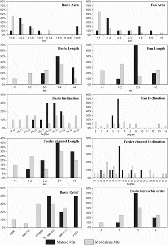
The catchment basins feeding the fan systems are made up primarily of Mesozoic dolostones, limestones, and locally by siliceous-marly-clayey successions (see ‘Location and geological setting’ in the upper left-hand corner of the map and the legend of Main Maps 1A and 2A). The areas in question consist of complex fan systems, ranging in age from the Late Middle Pleistocene to the Holocene. As regards their main morphometric attributes (), the basins are characterized by high relief energy (700–1000 m), have mean inclinations between 20° and 37°, half of them have an area of less than 3 km2 while the hierarchical order (sensu CitationHorton, 1945) does not exceed group 4 (at a map scale of 1:5,000). Detailed morphometric characterization of these basin/fan systems in terms of dominant transport processes was proposed by CitationSantangelo et al. (2012).
Figure 1. Distribution of the main morphometric parameters in the analyzed basin/fan systems.
The piedmont areas under study are moderately urbanized: entire villages and towns (Raviscanina, S. Angelo d'Alife, Piedimonte Matese, Sala Consilina, Padula) often dating back to Roman or Medieval times have developed on the alluvial fan surface, and a strong interaction between human activity and stream activity is recorded. This interaction is immediately evident from consultation of the relevant literature and archives (CitationSantangelo et al., 2012). Starting from 1581, there is evidence of more than 30 alluvial events which often caused severe damage to property and infrastructure, and in many cases, also loss of life ( and ). This suggests that identification of alluvial fan flood-prone zones in the study area is a requirement for hazard planning.
Figure 2. Evidence of historical flood events in the study areas. (a) and (b) Sala Consilina town (1927) (Maddalena Mts); (c) and (d) Piedimonte Matese town in 1966 (MateseMts); (e) Alife town in 1948 (MateseMts) and (f) Raviscanina town in 2002 (MateseMts). (Modified by CitationCaiazza, 2002).
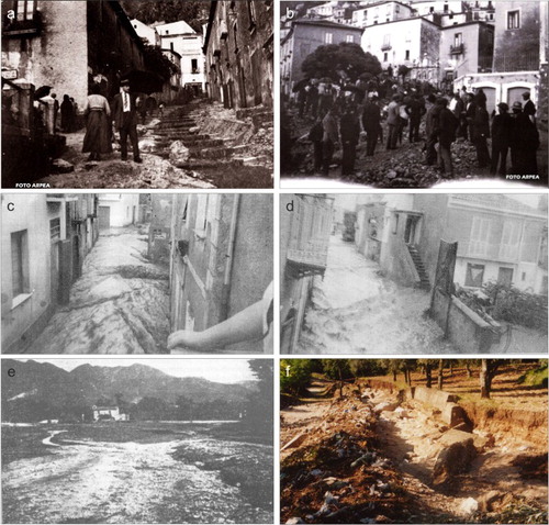
Table 1. Historical data set of past floods.
3. Methods
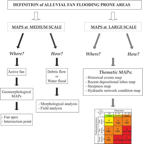
The following analysis was carried out and several thematic maps at different scales were subsequently produced (). First, we used a medium-scale (1:30,000) approach to identify the active portions of the piedmont areas (i.e. to establish ‘where’ flooding might occur). Second, we used a larger scale (1:2,000) approach, allowing the areas susceptible to different levels of hazard to be identified within a single fan.
Figure 3. Flow chart of the applied methods.
In the medium-scale analysis, we identified the flood-prone areas according to the recommendations of the CitationNRC (1996), which state that the active portions of a fan (Special Flood Hazard Areas) may be considered those located down-fan with respect of the intersection point (sensu CitationBlair & McPherson, 1994; CitationHooke, 1967).
In the study areas, the alluvial fan systems generally consist of different generations of fans which can be superimposed or entrenched (see sketch 1 in the ‘Flood susceptibility assessment at medium-scale’ box and Main Maps 1A and 2A). For each fan, through detailed analysis of the topographic maps, we identified and plotted the fan apex, the incised channel and the intersection point. We considered all fan portions located down-fan of the intersection point as active. The fan's lateral boundaries were defined on the basis of changes in the shapes of contour lines on the topographic maps. In order to achieve these goals, medium-scale aerial photos taken in 1981 (1:33,000), and orthophotos from 1998 were used. Geomorphological and topographic analyses were combined with field surveys to verify height of fluvial scarps, state of activity of fans, channel condition and the sedimentary characteristics of deposits (see Main Maps 1A and 2A).
The final layout of the maps was edited in Corel Draw, and represented at a scale of 1:30,000. Different contour line spacings were used to represent mountain front and piedmont areas, enhance map readability and allow intersection points to be distinguished. The basin areas were transferred to a topographic map base consisting of 100-meter contours. The contour lines were obtained from the DEM. The piedmont areas were represented with a topographic map derived from the 1:5,000-scale CTR sheets, published by the Campania Regional Authority.
In order to further assess the intensity of potential flooding, we considered the results of CitationSantangelo et al. (2012) who, by means of a multidisciplinary approach applied to a database comprising 102 alluvial fan systems including our study areas, were able to discriminate between debris flow and water flood fans. The method proposed by the authors is based on stratigraphic analysis of the fans and morphometric analysis of the basin–fan systems. In particular, the stratigraphic analysis together with statistical analysis of the morphometric variables was used to classify the fans in terms of the transport process involved. The results indicate that in the context examined, the best discrimination between debris flow (Df) and water flood (Wf) processes is achieved by means of two related variables, one for the basin (feeder channel inclination, Cg) and one for the fan (fan length, Fl). The authors propose the following linear equation:(1)
The alluvial fan is water flood-dominated if Fx > 0, while it is debris flow-dominated if Fx < 0.
The probabilities of belonging to Wf transport were evaluated by means of the logistic function:(2)
Here, a P value (P(F(x))) exceeding 0.5 indicates that a basin/fan system belongs to group ‘Wf’.
We add this information to the map with different colors for the Df and Wf fans (see sketches S1A and S2A on the map).
Large-scale analysis was applied to six fans in the Maddalena Mts. We followed the method proposed by CitationSantangelo et al. (2011) which allows the construction of a flood susceptibility map by means of a map overlay procedure based on the susceptibility matrix. In particular, we discuss here the four ‘base’ maps required for this application: historical events map, recent lobes map, steepness map and hydraulic and road network conditions (see Main Maps 1b, 2b, 3b, and 4b).
4. Legend explanation and map descriptions
4.1. Medium-scale maps
Main Maps 1A and 2A are geomorphological maps intended to identify the active portions of the piedmont areas. The main geomorphologic units (mountain front, piedmont area and alluvial plain) were first identified. The mountain fronts unit was characterized with reference to its substrate and covering deposit. The substrate is made up mainly of dolostones, limestones or siliceous-marly-clayey successions. Covering deposits may have a debris or colluvial genesis. This geomorphologic unit is affected mainly by fluvial erosion processes which allowed the formation of wide drainage basins which were mapped and classified, taking into account their hierarchical order (CitationStrahler, 1957). The main stream was also described by means of its cross-section (V, U or flat shaped) in order to provide information on erosion and deposition processes occurring along the main channels of the basins.
In the piedmont unit different shades of green were used to distinguish inactive (lighter green) and active (medium green) zones of the fans and the historical lobes (darker green). They were mapped by locating the fan apexes and the intersection points (CitationBlair & McPherson, 1994; CitationHooke, 1967), and by evaluating the height of the main channel banks (divided into three classes: higher than 5 m, between 2 and 5 m and less than 2 m). All the remaining portions of the piedmont area were mapped as inactive fans. They are at present dissected and lack any evidence of recent alluvial flood events.
In order to complete our analysis, channels were classified into natural (blue solid line), abandoned (blue dashed line) or man-modified (fuchsia). Man-modified channels were distinguished into underground channels (fuchsia solid line) or those with weirs (fuchsia dashed line). Finally, when present, some morphologies also due to gravity processes (debris cones and colluvium) were mapped.
Rapid comparison between the two maps immediately provides an idea of a different zonal distribution in terms of fan activity between the two areas. In the case of the Matese piedmont (Main Map 1A), the flood-prone zones are less extensive and located in the distal sector, while, in the case of the Maddalena mountains (Main Map 2A), they cover a wider area and in many cases are located in the proximal portion of the piedmont unit. Obviously, this makes a difference in terms of land-use planning.
In order to obtain information on the possible magnitude of the event, we considered data from CitationSantangelo et al. (2012) regarding fan classification in terms of transport processes (debris flow vs. water flood) and added this information to sketches S1A and S2A. As can be observed, in the case of the Matese piedmont, all the studied fans were classified as water flood-dominated; in the case of the Maddalena piedmont, both types are present in roughly equal proportions, but the Df fan is clearly concentrated in the central area, in proximity to the town of Sala Consilina. The example shows that by comparing different geomorphological maps, it is possible to understand rapidly and straightforwardly which portions of the piedmont it is necessary to focus on with a large-scale approach.
4.2. Large-scale maps
Based on the previous results, large-scale mapping was applied to the six fans in the Maddalena Mts, over which the town of Sala Consilina was built. The area was also selected because it is highly urbanized and in recent centuries has been affected by severe floods. The main aims of this large-scale analysis were: (i) to highlight the areas previously hit by alluvial events and identify potential future flooding or depositional zones; (ii) to highlight the possible interaction between flow propagation and human infrastructure. All these data can be considered as negative predisposing factors in the case of alluvial events.
Main Map 1b (map of historical events) and Main Map 2b (map of recent lobes) were drawn up in response to the first point. The map of historical events (1b) includes the location of damage produced by nine major alluvial events (CitationSantangelo et al., 2011) recorded from 1806 to 1947. On Main Map 2b, the recent lobes were mapped by means of the detection of contour line anomalies and pronounced convexities on the active fan surface. This map allowed identification of several depositional lobes stretching up to 1 km from the apex to the distal part of the fan. Both maps suggest that the areas most severely hit by flooding are located on the fan apex and near the main channel.
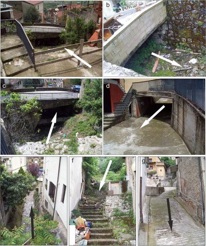
Maps 3b (steepness) and 4b (hydraulic network conditions) cover the second point. The steepness map includes the following ranges of slope angle: up to 6°, between 6° and 12° and exceeding 12°. These gradient variations can significantly influence the flow propagation during an alluvial event. The map of hydraulic network conditions (Map 4b and ) displays the main hydraulic features and road distribution which can influence and divert a flow. The main elements which were mapped are: main and secondary roads along which the flow can be channeled, an underground channeled stream (, photos a, b and d), a stream bed transformed into a road (, photos f and g), a weir showing a very poor degree of maintenance (filled in with coarse debris, vegetation and waste), critical points due to an abrupt change in stream direction and/or to the small cross-section of the stream (, photo e) and to other circumstances (as shown in the photographs c, ) such as those in which the stream bed is completely surrounded by buildings.
Figure 4. Examples of hydraulic critical points in Sala Consilina: (a), (b) (c) and (g) the main stream is channeled underground; (d) and (f) the stream re-emerges, but its bed has become a road; (e) the stream has a very small cross-section and is completely surrounded by houses.
The overlay of these four ‘base maps’ (CitationSantangelo et al., 2011) produced the susceptibility map (Map B) which allows identification, within a single fan, of areas prone to flooding in different ways. The map overlay procedure is based on a susceptibility matrix ( and Map B) which takes into account the main steepness classes and links them with the other natural and artificial predisposing factors. In particular, the three classes of steepness data were linked with the presence of ancient depositional lobes, with the presence of artificial anomalies on the fan surface (street orientation, stream deflection, critical points) and with the occurrence of historic events. To each slope class, an increasing score from 1 to 3 was assigned and thus the first three zones with different susceptibilities were detected. The other three aggravating parameters were then considered, each with a score equal to 1. Based on their presence/absence, three other levels (ranging from 1 to 3) of scores were defined. The following layer intersections allow four different susceptibility classes to be detected.
The very high susceptibility zones (in red), generally located on the fan apex or along the main channel, can be considered the direct impact zones in the event of debris flow phenomena. Based on sedimentological observation collected during field survey (CitationSantangelo et al., 2011) and historical evidence (photos), the material transported through these zones could include boulders up to one meter in diameter, tree trunks, coarse debris and the obstruction of the main hydraulic channel if the stream has been forced to flow underground.
The high susceptibility zones (in orange) are those where the flows may be diverted and/or through which flows may subsequently travel. Their distribution is strongly influenced by the presence and orientation of the main streets and buildings. Material may include rocks and debris but is more likely to contain boulders less than 0.5 m in diameter to fine-grained material. The potential damage is strictly linked to water discharge and its velocity.
The medium susceptibility zones (in yellow) are located in the middle fan area and may be affected by the distal or lateral portion of flows carrying finer materials. Flooding of the buildings base level floor and low water level (some dm) along the streets may be expected.
Finally, the low susceptibility zones (in green) are those with low gradients, located on the distal part of the fans where other negative predisposing factors are absent. They are exposed only to flooding; sizable damage is not expected since the water level (several cm) will probably be low and only fine-grained material and mud should be contained in the flood water.
5. Conclusions
Flood susceptibility assessment in a piedmont area can be carried out by means of geomorphological studies at different scales according to the extent of the area affected and the accuracy of the available data. Geomorphological mapping integrated with field surveys, remotely sensed data and historical analysis may be considered an efficient tool to predict potentially floodable areas for future events.
Small- and medium-scale maps can be considered for preliminary analysis. They provide important information for large areas, and allow identification of zones which need in-depth investigation. Larger scale maps allow zoning of even small areas, and provide accurate information for decision-makers called upon to plan hazard management. In general, geological and gemorphological thematic maps may be very useful in the hazard planning of a piedmont area and may represent the first step for further studies, mainly for hydraulic purposes, to define models of flow propagation. Such models will have to take into account the presence and state of hydraulic features and their interaction with urban infrastructure, particularly the distribution of buildings and street orientation.
Software
DTMs and spatial analyses of DTMs were performed using Esri ArcMap10, using the Spatial Analysis Toolbox. The final layout was created with CorelDrawX5.
Multiscale map analisys in alluvial fan flooding prone areas
Download PDF (14.2 MB)Disclosure statement
No potential conflict of interest was reported by the authors.
References
- Aleotti, P., & Chowdhury, R. (1999). Landslide hazard assessment: Summary review and new perspectives. Bulletin of Engineering Geology and the Environment, 58, 21–44. doi: 10.1007/s100640050066
- Aulitzky, H. (1980). Preliminary two-fold classification of torrents. Proceedings International Symposium Interpraevent, Bad Ischl, vol. 4, pp. 285–309.
- Berti, M., & Simoni, A. (2007). Prediction of debris flow inundation areas using empirical mobility relationships. Geomorphology, 90, 144–161. doi: 10.1016/j.geomorph.2007.01.014
- Bertolo, P., & Bottino, G. (2008). Debris-flow event in the Frangerello Stream-Susa Valley (Italy) – calibration of numerical models for the back analysis of the 16 October, 2000 rainstorm. Landslides, 5, 19–30. doi:10.1007/s10346-007-0099-7
- Bertrand, M., Liébault, F., & Piégay, H. (2013). Debris-flow susceptibility of upland catchments. Natural Hazards, 67, 497–511. doi: 10.1007/s11069-013-0575-4
- Blair, T. C., & McPherson, J. G. (1994). Alluvial fan processes and forms. In A. T. Abrahams & A. J. Parsons (Eds.), Geomorphology of desert environments (pp. 354–402). London: Chapman and Hall.
- Bull, W. B. (1968). Alluvial fans. Journal of Geology, 16, 101–106.
- Bull, W. B. (1977). The alluvial fan environment. Progress in Physical Geography, 1, 222–270. doi: 10.1177/030913337700100202
- Caiazza, D. (2002). I torrenti assassini del Matese Meridionale. Atti del Convegno di Studi sulle alluvioni catastrofiche recenti negli insediamenti urbani: il rischio e la prevenzione dopo il disastro di Sarno. Piedimonte Matese, 31 October 1998, Alife. Alife: Comune di Alife.
- Canuti, P., & Casagli, N. (1996). Considerazioni sulla valutazione del rischio di frana. Atti del Convegno, Fenomeni Franosi e centri abitati, Bologna May 27, 1994, C.N.R.-G.N.D.C.I, 846, pp. 29–130.
- Capparelli, G., Versace, P., & Biondi, D. (2013). A contribution for the assessment of sliding susceptibility in Sarno area, Southern Italy. Geotechnical Special Publication, Geo-Congress, 1023–1033. doi:10.1061/9780784412787.104
- Cascini, L., Bonnard, C. H., Corominas, J., Jibson, R., & Montero-Olarte, J. (2005). Landslide hazard and risk zoning for urban planning and development state of the Art report (SOA7). In O. Hungr, R. Fell, R. Couture, & E. Eberthardt (Eds.), Proceedings of the international conference on landslide risk management Vancouver (Canada) (pp. 199–235). London: Taylor and Francis.
- Castelli, M., Bonnard, C. H., Durville, J. L., Forlati, F., Poisel, R., Polino, R., … Scavia, C. (2002, May). IMIRILAND project – impact of large landslides in the mountain environment: Identification and mitigation of risk. Proc. int. conf. on Instability – Planning and Management, Isle of Wight, UK, Thomas Telford, pp. 671–678.
- Costa, J. E. (1988). Rheologic, geomorphic and sedimentologic differentiation of water floods, hyperconcentrated flows, and debris flows. In R. R. Baker, R. C. Kochel, & C. Patton (Eds.), Flood geomorphology (pp. 113–122). New York, NY: Wiley.
- Crosta, G. B., & Frattini, P. (2004). Controls on modern alluvial fan processes in the Central Alps, Northern Italy. Earth Surface Processes and Landforms, 29, 267–293. doi: 10.1002/esp.1009
- De Scally, F. A., & Owens, I. F. (2004). Morphometric controls and geomorphic responses on fans in the Southern Alps, New Zealand. Earth Surface Processes and Landforms, 29, 311–322. doi: 10.1002/esp.1022
- De Scally, F. A., Owens, I. F., & Louis, J. (2010). Controls on fan depositional processes in the schist ranges of the Southern Alps, New Zealand, and implications for debris-flow hazard assessment. Geomorphology, 122, 99–116. doi: 10.1016/j.geomorph.2010.06.002
- Guzzetti, F., Stark, C. P., & Salvati, P. (2005). Evaluation of flood and landslide risk to the population of Italy. Environmental Management, 36(1), 15–36. doi: 10.1007/s00267-003-0257-1
- Hashimoto, A., Oguchi, T., Hayakawa, Y., Lin, Z., Saito, K., & Wasklewicz, T. A. (2008). GIS analysis of depositional slope change at alluvial-fan toes in Japan and the American Southwest. Geomorphology, 100, 120–130. doi: 10.1016/j.geomorph.2007.10.027
- Hooke, RLeB. (1967). Processes on arid region alluvial fans. The Journal of Geology, 75, 438–460. doi: 10.1086/627271
- Horton, R. E. (1945). Erosional development of streams and their drainage basins: Hydro-physical approach to quantitative morphology. Geological Society of America Bulletin, 56(3), 275–370. doi: 10.1130/0016-7606(1945)56[275:EDOSAT]2.0.CO;2
- Hurlimann, M., Copons, R., & Altimir, J. (2006). Detailed debris flow hazard assessment in Andorra: A multidisciplinary approach. Geomorphology, 78, 359–372. doi: 10.1016/j.geomorph.2006.02.003
- Jalayer, F., De Risi, R., De Paola, F., Giugni, M., Manfredi, G., Gasparini, P., … Renner, F. (2014). Probabilistic GIS-based method for delineation of urban flooding risk hotspots. Natural Hazard doi:10.1007/s11069-014-1119-2
- JTC-1. (2008). International guidelines for landslide susceptibility, hazard and risk zoning. Engineering Geology, 103, 85–98.
- Melton, M. A. (1965). The geomorphic and paleoclimatic significance of alluvial deposits in Southern Arizona. The Journal of Geology, 73, 1–38. doi: 10.1086/627044
- National Research Council. (1996). Alluvial fan flooding (pp. 1–131). Washington, DC: National Academy Press.
- Olivares, L., & Picarelli, L. (2003). Shallow flow slides triggered by intense rainfalls on natural slopes covered by loose unsaturated pyroclastic soils. Geotechnique, 53(2), 283–287. doi: 10.1680/geot.2003.53.2.283
- Pelletier, J. D., Mayer, L., Pearthree, P. A., House, P. K., Demsey, K. A., Klawon, J. E., & Vincent, K. R. (2005). An integrated approach to flood hazard assessment on alluvial fans using numerical modeling, field mapping and remote sensing. Geological Society of America Bulletin, 117, 1167–1180. doi: 10.1130/B25544.1
- Santangelo, N., Daunis-i-Estadella, J., Di Crescenzo, G., Di Donato, V., Faillace, P., Martin-Fernandez, J. A. … Scorpio, V. (2012). Topographic predictors of susceptibility to alluvial fan flooding, Southern Apennines. Earth Surface Processes and Landforms, 37, 803–817. doi:10.1002/esp.3197
- Santangelo, N., Santo, A., Di Crescenzo, G., Foscari, G., Liuzza, V., Sciarrotta, S., & Scorpio, V. (2011). Flood susceptibility assessment in a highly urbanized alluvial fan: The case of Sala Consilina (Southern Italy). Natural Hazards Earth System Sciences, 11, 2765–2780. doi: 10.5194/nhess-11-2765-2011
- Sorbino, G., Sica, C., & Cascini, L. (2010). Susceptibility analysis of shallow landslides source areas using physically based models. Natural Hazards, 53(2), 313–332. doi: 10.1007/s11069-009-9431-y
- Sorriso-Valvo, M., Antronico, L., & La Pera, E. (1998). Controls on fan morphology in Calabria, Southern Italy. Geomorphology, 24, 169–187. doi: 10.1016/S0169-555X(97)00079-2
- Strahler, A. N. (1957). Quantitative analysis of watershed geomorphology. American Geophysical Union Transactions, 38, 913–920. doi: 10.1029/TR038i006p00913
- Van Westen, C. J. (2000). The modelling of landslide hazards using GIS. Surveys in Geophysics, 21, 241–255. doi: 10.1023/A:1006794127521
- Welsh, A., & Davies, T. (2011). Identification of alluvial fans susceptible to debris flow hazards. Landslides, 8, 183–194. doi: 10.1007/s10346-010-0238-4
- Wilford, D. J., Sakals, M. E., Innes, J. L., Sidle, R. C., & Bergerud, W. A. (2004). Recognition of debris flow, debris flood and flood hazard through watershed morphometrics. Landslides, 1, 61–66. doi: 10.1007/s10346-003-0002-0