
Abstract
This article presents a morpho-sedimentological map of a Mediterranean embayed microtidal wave-dominated beach system and related inner shelf. The study area is located between Capo Boi and the Torre de su Fenugu sector, and focuses on Solanas beach in SE Sardinia. All of the collected data were processed to draw a main 1:7,000 scale map, which shows the general characteristics of the entire area, including its hydrodynamic, morphological, and sedimentological features (distribution of siliciclastic and biogenic/bioclastic sediments), rocky outcrops, beach rocks, and marine phanerogam meadow coverage (mainly Posidonia oceanica). Several secondary maps such as routes and paths, side-scan sonar photomosaic interpretations, and sedimentary facies have also been included. In addition to its scientific value, the map can be an important tool for beach management purposes.
1. Introduction
This work describes the morpho-sedimentological map of a microtidal embayed Mediterranean wave-dominated beach system (emerged and submerged beach) and related inner shelf. The study covers the area between Capo Boi and Torre de su Fenugu (Main Map), with particular attention paid to the hydrodynamic aspects and morpho-sedimentological layout of Solanas beach (Main Map). The main purpose of this study is to test integrated mapping (geomorphology, sedimentology, and morphodynamic) that also includes ecological elements.
The study area and its adjacent inner shelf are located in the Gulf of Cagliari, which is in the centre of the eastern Mediterranean Sea, south of Sardinia (Main Map), and have been studied by Cagliari University since the 1980s. De Muro and Kalb set up the first morphodynamic studies of the beach system of Solanas in 2001 (CitationKalb, 2002), and also carried out the first mapping of sediments from the sea bottom (CitationDe Muro & Kalb, 2003). At a later stage (CitationDe Muro, Batzella, Kalb, & Pusceddu, 2008; CitationKalb, 2008), the studies were continued due to new research projects financed by the Regione Autonoma della Sardegna (Project ‘RIsposta e Adattamento dei sistemi costieri della Sardegna alle variazioni climatiche globali’ RIAS and ‘Beach Environment, Management and Coastal Hazard’ BEACH – L.R. 7/2007 ‘Promozione della ricerca scientifica e dell'innovazione tecnologica in Sardegna’). In particular, in-depth research (CitationDe Falco et al., 2014) was conducted regarding the marine phanerogam meadow (CitationDe Falco, De Muro, Batzella, & Cucco, 2011; CitationSimeone, De Muro, & De Falco, 2013) and its ‘factory’ role in the Mediterranean area (CitationLecca, De Muro, Cossellu, & Pau, 2005).
The map was produced using a topographic–bathymetric, textural, and compositional database, and shows the general characteristics of the entire area, including morphologies; sedimentological features (distribution of siliciclastic and bioclastic sediments); the main rocky outcrops relating to the various lithologies of the basement; the most recent beach rock; and the marine phanerogam coverage, which is chiefly Posidonia oceanica (L) Delile meadow.
The twofold role of the P. oceanica (L) Delile meadow is clear and fundamental, acting as: (1) a barrier for siliciclastic material from the emerged beach and (2) a producer of biogenic/bioclastic material (CitationBatzella et al., 2011a, Citation2011b; CitationDe Falco, Molinaroli, Baroli, & Bellacicco, 2003; CitationDe Muro, Kalb, Ibba, Ferraro, & Ferrara, 2010; CitationDe Muro, Batzella, Kalb, De Falco, & Pusceddu, 2011; CitationPusceddu et al., 2011, Citation2012).
Along with this database, other information is also available concerning the Solanas beach test (Main Map), in particular regarding the study of winds, waves, and currents (hydrodynamic scenarios) relating to the geographical fetch and relative hydrodynamic response.
The distribution of superficial sediments is also described, as are the forms taken by the main sedimentary bodies of the submerged beach (bar and trough) that are the result of the area's hydrodynamics (longshore and rip current).
The legend is made up of 36 items, divided into 7 main sections.
The first describes the forms and processes of the dry beach that are mainly characterized by a siliciclastic composition (dunes and back shore). Information includes areas affected by the deposition of the ‘seagrass berm’ (Banquette) according to CitationDe Falco et al. (2008) and CitationSimeone, De Falco, Como, Olita, and De Muro (2008).
The second section comprises first-illustrated forms and processes that affect the shoreface and inner shelf, whereas the hydrodynamic data conclude that the treatment of the elements is also linked to forms and processes. The hydrodynamic features were reconstructed using sedimentological and morphodynamic data (seasonally acquired), as well as information concerning winds, waves, and currents.
The third section describes sediment features according to their environmental origin (siliciclastic or bioclastic) and texture. It also includes a description of the sedimentological characteristics of depression intermattes (coarse and very coarse bioclastic sediment).
The fourth section describes the other characteristics of the sea bottom, such as the distribution of the phanerogam meadow, beach rocks, and other undifferentiated rocky outcrops.
The last three sections are an aid to understanding the hydrographic, topographic, and bathymetric features (river, contour lines, depth lines, main hydrography features, etc.), as well as the forms linked to human activity.
2. Study area
2.1. Geographical setting
The study area is located in the central-southern sector of the Mediterranean Sea, in the south-east of Sardinia in the Gulf of Cagliari. The coastal area shown on the map extends for a total of 4 km and includes two beaches: Genna'e Mari and the main beach of Solanas (Main Map). The beaches extend for 520 and 950 m, respectively, and are developed on a NW–SE axis.
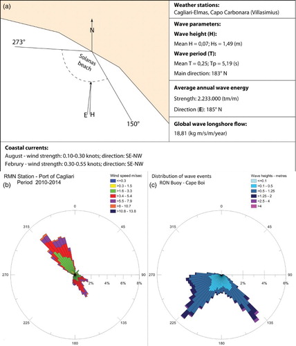
The coast section analysed is mainly exposed to winds and waves (between 150° and 273°, (a)), and is protected by the Capo Boi headland to the south and the Torre de su Fenugu headland to the north. The section is affected by wave action, which is intense at times, with a modest net energy flow from the SE to the NW (CitationDe Muro & Kalb, 2010). The main geographical fetches are registered between 150° and 160° (280 km) and between 273° and 240° (480 km).
Figure 1. (a) Solanas weather data (CitationVV.AA., 1987 modified); (b) Wind data (RMN Station – Port of Cagliari) (c) distribution of wave events (Rete Ondametrica Nazionale – RON Buoy Cape Boi).
Solanas beach, which was studied in more detail (Main Map), receives sedimentary material mainly from the hydrographic basin of Rio Solanas, which is a seasonal stream occupying an area of about 34 km2.
2.2. Geological setting
The basement lithologies () are characterized by Paleozoic outcrops belonging to the Sarrabus granitoid complex, which can be attributed to the Upper Carboniferous-Permian, and is mainly made up of monzogranitic granodiorites (CitationCarmignani et al., 2008; CitationVV.AA., 2008).
Figure 2. Geological scheme of the study area (CitationVV.AA., 2008, modified).
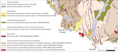
There is also a sill-type complex that is typical of the southern Sarrabus, which is principally oriented NW–SE and NNW–SSE. It is characterized by a basalt composition, veins of granitic porphyries, masses of microgranites, and aplitic and pegmatic veins (CitationCarmignani et al., 2001, Citation2008).
In the centre of the study area and up-valley of the marine area, conglomerates and debris from the Tertiary, which are related to the Ussana Formation, crop out (Upper Oligocene–Aquitanian) (CitationCarmignani et al., 2008; CitationCherchi, Marini, Murru, & Ulzega, 1978; CitationVV.AA., 2008).
Quaternary lithologies are mainly characterized by Pleistocene and Holocene deposits. Pleistocene deposits are made up of terraced alluvial gravels (medium to coarse), with subordinate sands (Upper Pleistocene, Lithofacies in the Subsynthem of Portoscuso, synthem of Portovesme). ‘Ancient’ beach deposits are present, with a thickness up to 3–4 m, and are made up of sands, sandstones, calcirudites, bivalve gravels, gasteropods with subordinate sandy–silty deposits, and calcilutites of coastal pools (Upper Pleistocene–Holocene) (CitationVV.AA., 2008). Holocene deposits belong to both littoral and alluvial environments (CitationVV.AA., 2008).
There are terraced alluvial deposits (gravels and coarse sands) and eluvial–colluvial sandstones composed of debris immersed in a fine matrix. At times, there is the insertion of soils.
In the shoreface area of the two main beaches of Solanas and Genna'e mari, sandstones and conglomerates in the facies of the beach rocks crop out. According to previous studies (CitationDe Muro & Orrù, 1998), their presence is due to the high stand of the Holocene sea −1 to −5 m (500–3000 BP). There are also beach deposits consisting of sands and gravels and Aeolian deposits made up of well-classed dune sand.
3. Methods
The morpho-sedimentological map integrates the findings of the studies carried out since 2001 (Main Map) with newly acquired data (the ‘Golfo di Cagliari 2001/02’, ‘Solanas'06’, ‘Solanas'07’ and ‘Solanas 2011’ campaigns). The map uses the ‘Carta Tecnica Regionale’ (CTR) topographic base map at the 1:10,000 scale, with sections 567060 ‘Solanas’ and 567050 ‘Torre delle Stelle’ produced by the ‘Regione Autonoma della Sardegna' (CitationVV.AA., 1998).
Research for the study of the Solanas beach system was carried out following the methodology set up and adopted by the Coastal and Marine Geomorphology Group, University of Cagliari (CitationDe Muro et al., 2012; CitationDe Muro, Brambilla, Kalb, & Ibba, 2013; CitationDe Muro, Kalb, Pusceddu, & Ibba, 2013), which was established to study the sedimentological and morphodynamic processes of Mediterranean microtidal wave-dominated beaches.
The beaches were studied seasonally, with the aims being to: (1) evaluate sedimentary and morphodynamic processes, anthropic effects, criticality, and evolutionary trends and (2) provide management guidelines.
The studies were carried out in accordance with the flow chart in . This illustrates the configurations of the instrumentation used and the work performed.
Figure 3. Methods flow chart (CitationDe Muro et al., 2012; CitationDe Muro, Kalb et al., 2013, modified).

The historical reconstruction of the evolution of the area was conducted for each beach by interpreting aerial photographs in order to identify ‘macro indicators’ such as the extension of the dune area, the position of the shoreline, the distribution of marine phanerogams (e.g. P. oceanica, etc.), anthropological elements (buildings and coastal infrastructure, for example), and hydrography. This enables the evaluation of the evolution of the area in the short and medium terms. All of the data acquired were linked to a geodetic network of points created on all the beaches. The topographical data were acquired using differential global positioning system (DGPS) or global navigation satellite system (GNSS) and/or StarFire systems with a point sampling frequency of 1 Hz.
On a dry beach, DGPS was used to plot 16 topographical transects, and the position of the shoreline was charted 6 times (4 seasonal surveys and 2 surveys repeated annually).
Single-beam, multi-beam, and side-scan sonar systems (all with GPS) were used for the shoreface inner shelf survey. All the results are stored in the UTM – WGS84 Datum coordinate system.
A total of 18 nm multi-beam echo-sounder profiles, 10.3 nm single-beam echo-sounder profiles, and 12.5 nm side-scan sonar profiles were obtained and 103 sediment samples were taken using a Van Veen grab with a 5 dm3 capacity.
The sediments collected from the morpho-sedimentological units along the transverse transects (dune-dry beach-foreshore-shoreface-inner shelf) were analysed according to standard sedimentological methods (texture, composition, and facies analysis). In addition, a number of scuba dives were performed along the P. oceanica upper limit in order to complete the survey and conduct supplementary geomorphological checks.
Side-scan sonar sonogram readings permitted the identification and mapping of three main types of sea bottom: (1) areas with sediment, (2) rocky outcrops, and (3) the distribution of the P. oceanica (L.) Delile meadow's ecosystem (CitationBartole & De Muro, 2012; CitationFish & Carr, 1990).
The grain size distribution was determined following the ASTM international standard methodology, with sieves spaced on 1/4Φ between 2000 and 63 μm (Udden–Wentworth scale, Citation1922).
Sediment grains for each sample and grain size class were classified under a binocular microscope according to their mineralogical composition by distinguishing quartz, feldspars, micas, other minerals, lithoclasts, and skeletal grains. The volume percentage of each mineralogical and compositional class was determined using the areal comparison method (CitationLewis & McConchie, 1994). The samples were grouped in compositional facies according to the classification proposed for the Gulf of Cagliari area (CitationDe Muro, Lecca, Cossellu, Kalb, & Pusceddu, 2008; CitationLecca et al., 2005) and implemented for the Bonifacio Straits by CitationDe Falco et al. (2011).
The bathymetric and sedimentological data were used along with an analysis of weather conditions to construct wave and hydrodynamic models of Solanas beach. These were based on digital terrain models (DTM) built from bathymetric–topographical data and the results of sedimentological, meteorological–climatic, and current speed/direction analyses.
The key was drafted by using as references: (1) the Geomorphological Map of Italian Guidelines at a scale of 1:50,000 (CitationVV.AA., 1994) and (2) the Italian Geological 1:50.000 Scale Map (CitationVV.AA., 2009).The key was integrated and adapted to suit the aims of this work and with regard to the available data and the variety of morphological features in the area.
4. Sedimentological and hydrodynamical features of the Solanas beach system and related inner shelf
The textural distribution was measured on seven transverse transects by way of a scuba dive performed with direct immersion on the sea bottom. The average dimension of the grains typically increases from the shoreline to the dry beach-back shore and then decreases towards the dunes (according to a classical model of shoreline-slope dispersion). The average granulometric percentages ((a)) reveal a predominance of coarse sediments in the dry beach-dune system (gravels 16%, very coarse sands 31%, coarse sands 15%). On the shoreface, the sediments are mainly medium-fine (medium sands 35% and fine sands 39%).
Figure 4. (a) Textural charts; (b) compositional charts.
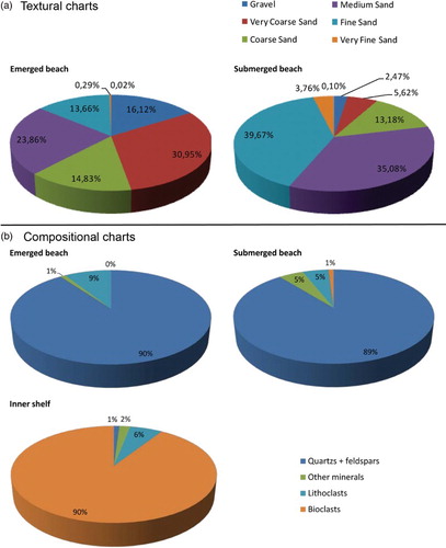
The distribution of the average grain size along the transects reveals: (1) the normal coast-sea transition, which goes from the step and is made up of coarse sands and (2) the surf-zone, which comprises medium to fine sands (2Φ). Proceeding out from the coastline, near the upper limit of the phanerogam meadow, the trend is inverted, with a continual strip of coarse sands prevailing, and with a siliciclastic composition that is close to the upper limit of P. oceanica. The shoreface sediments are progressively enriched in bioclasts, with percentages ranging from 5% to 90% (due to contact with the rhizomes) seaside, going on to define a mixed bioclastic–siliciclastic facies.
The width of this transition zone (from the ‘siliciclastic shoreface facies’ to the ‘mixed bioclastic silciclastic facies’ linked to the productivity of P. oceanica) varies between 5 and 20 m.
The compositional analysis ((b)) shows a prevalence of siliciclastic components (quartz + feldspars 90%, other minerals 1% and lithoclasts 9%), whereas the bioclastic component is almost absent in the shoreface but becomes significant and evident in the transition from the shoreface to the P. oceanica meadow upper limit.
The siliciclastic components also prevail in the shoreface, with a high percentage of quartz and feldspars, and a minimum presence of bioclasts that reaches 5% at the most (quartz + feldspars 85%, other minerals 5%, lithoclasts 10%, and bioclasts 1%). These sediments are delimited between the shoreline and the upper limit of the P. oceanica meadow.
The quantity of the bioclastic component rises significantly in the samples taken from near the lower limit of the P. oceanica meadow. These sediments become coarse inside the bioherm (intermattes) and very coarse under the lower limit of the Posidonia meadow, reaching 80–90% (CitationDe Falco, Ferrari, Cancemi, & Baroli, 2000; CitationDe Muro, Batzella et al., 2008; CitationDe Muro et al., 2010).
A morphoscopic analysis, which was carried out to measure roundness, shows that the sediments from all the morphological units of the emerged and submerged beach are not variable (between angular and sub-angular on the Powers scale, Citation1953). From the results it is evident that the beach system remains stable due to the supply of solid material from the flooding events of the Rio Solanas.
As mentioned previously, the shoreface sediments are characterized by a siliciclastic composition with mainly quartz and feldspars. Approaching the upper limit of the P. oceanica, we observed a transition to mixed components that are increasingly rich in a bioclastic constituent. This is mainly due to bivalve and gasteropod shells, fragments of carbonatic algae, bryozoas, and red algae, and is closely linked to the ecosystem of the P. oceanica (L) Delile meadow shown on the map. The study of the samples has enabled four facies to be distinguished (Main Map):
Siliciclastic sands and gravels: facies composed of shoreface sands, gravelly sands, and gravels, mainly siliciclastic.
Mixed bioclastic and siliciclastic gravels and sands: facies composed of biogenic/bioclastic and siliciclastic sands, gravelly sands, and gravels, linked to the transition from the shoreface to the Posidonia meadow's upper limit.
Biogenic gravelly sands: facies composed of biogenic gravelly sands linked with the Posidonia meadow (intermattes).
Detritic gravelly sands: facies composed of mainly bioclastic mixed gravelly sands and gravels, linked to the Posidonia meadow's lower limit.
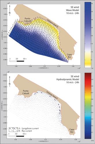
The information regarding hydrodynamics was reconstructed using sedimentological data, morphodynamic data acquired seasonally, and data regarding winds, waves, and currents. Three main hydrodynamic scenarios have been identified in the area of Solanas beach. These are responsible for controlling sediment transportation and for the arrangement of the bars and troughs. These typical wind currents are induced by winds blowing from the SE, SW, and NW ((b)).
A SE–NW longshore current is generated by winds and waves from the SE (). This current creates a transport flow towards the NW sector of the beach and has created a small bar and trough (NW sector of the beach). This scenario delimits a surf-zone, which extends approximately 100 m from the shoreline.
Figure 5. Wave and hydrodynamic model induced by winds blowing from the SE.
Waves and hydrodynamics () generated by the SW wind show the formation of a longshore current, which is parallel to the coast in the central and NW sector of the beach (red dashed-line arrows).
Figure 6. Wave and hydrodynamic model induced by winds blowing from the SW.
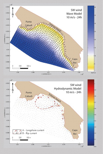
A few hours after the event begins, a rip current is generated in the SE sector that is orientated obliquely on a NE/SW axis. This current triggers a double cell circulation: clockwise in the NW sector, anti-clockwise in the SE sector. The rip current extends out for almost 1000 m SW. A dynamic area controlled by the morphology of the submerged beach can be seen between the shoreline and the upper limit of the Posidonia meadow. A surf-zone is created as a result of this scenario; its width increases in a 24 h period from 300 to 500 m. The area affected by this oscillation with winds from the third sector is shown on the map with the bar axis in an intermediate position.
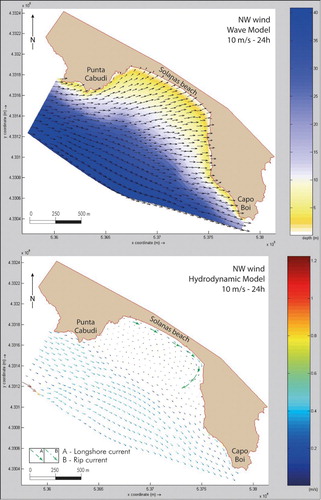
Winds and waves from the NW create a NW–SE longshore current (), and in the SE sector of the beach there is a rip current (brown dashed-line arrows). This scenario controls the distribution of the medium sands, generating a body of sediment in the shape of an asymmetric delta. Two orders of mainly longitudinal bars form in the central sector of the beach, delimiting an extensive surf-zone up to 100 m from the shoreline. On the map, the axis of the bar is shown in an intermediate position compared to the maximum and minimum oscillations.
Figure 7. Wave and hydrodynamic model induced by winds blowing from the NW.
5. Conclusions
The results of this morpho-sedimentological and hydrodynamic study allowed the 1:7,000 scale mapping of a Mediterranean microtidal wave-dominated embayed beach system with a marine phanerogam meadow and related inner shelf. The study area, which focuses on Solanas beach, is located in the SE sector of Sardinia in the Gulf of Cagliari, between the Capo Boi and Torre de su Fenugu headlands.
The key novelty is not only that static information on the sea bottom is shown on the Main Map, but that different hydrodynamic scenarios that contribute to the structuring on the Solanas beach system are also revealed. According to the map, the role of the marine phanerogam meadow, which is mainly characterized by P. oceanica (L) Delile, is clear and well defined.
In relation to the wave and hydrodynamic scenarios, siliciclastic sediments are redistributed along the shoreface between the shoreline and the upper limit of the Posidonia meadow. Above the upper limit of the meadow, there is a narrow transitional strip that is situated on the transition between the shoreface and seagrass domains, in which there are increasing biogenic and bioclastic sediments mixed with siliciclastic components. Only a small amount of bioclastic sediment is distributed in the surf-zone or dry beach. Most of the carbonatic production related to the marine phanerogams is distributed within the meadow and below its lower limit. These carbonatic sediments are distributed in strips parallel to the shoreline, as previously found along the Sardinian coast, producing a blanket of bioclastic sediments that are clearly visible on the map.
This highlights the key roles of the Posidonia meadow in microtidal embayed Mediterranean beaches: (1) containing terrigenous sediments and (2) producing important biogenic/bioclastic sedimentary flows.
The meadow physically retains sediments arising from the weathering of the rocks in the submerged area, guaranteeing the integrity of the beach with all its sedimentary bodies (dunes, dry beach, and shoreface) and limiting loss towards the deeper part. Similarly, it has the role of a biogenic/bioclastic material factory, guaranteeing supplies and checking sedimentation towards its lower depth limit.
Software
The DGPS data were analysed using GNSS Solutions, while Reson PDS2000 was used for the acquisition of bathymetric data. Autodesk Map 3D 2005 was used to create a georeferenced topographic–bathymetric basemap and depict the granulometric distribution of the sediments. Textural sediment classification and grain size parameters (CitationFolk, 1966; CitationFolk & Ward, 1957) were obtained for each sample using Gradistat (CitationBlott & Pye, 2001). The data were then manipulated using Global Mapper 14 to produce a land–sea DTM. The WAVE and FLOW modules of Deltares Delft3D were applied (CitationDe Muro & De Falco, 2010; CitationKalb, 2008) and verified using measurements and land studies. The final map was produced using Adobe Illustrator CS5.
Morpho-sedimentoloy of a Mediterranean microtidal embayed wave dominated beach system and related inner shelf with Posidonia oceanica meadows: the SE Sardinian coast
Download PDF (93 MB)Acknowledgements
The authors would like to thank ‘Corpo Forestale e di Vigilanza Ambientale CFVA’ and all the members of BLON, Cagliari. Thanks also go to the ‘Coastal and Marine Geomorphology Group’ of Cagliari University and to the ‘Osservatorio Coste E Ambiente Naturale Sottomarino OCEANS’ staff. The authors are also grateful to Carla Buosi and Marco Porta for text and map revision.
Disclosure statement
No potential conflict of interest was reported by the authors.
Additional information
Funding
Related Research Data
References
- Bartole, R., & De Muro, S. (2012). Acoustic facies and seabed features of the mixed carbonate-siliciclastic deposits of the last eustatic cycle in the Maddalena Archipelago (North Sardinia, Italy). Italian Journal of Geosciences, 131(1), 102–122. doi:10.3301/IJG.2011.28
- Batzella, T., Pusceddu, N., Kalb, C., Ferraro, F., Ibba, A., & DeMuro, S. (2011a). Bars and troughs dynamic and evolution trend of La Cinta beach (San Teodoro OT) – NE Sardinia. Rendiconti Online Della Società Geologica Italiana, 17, 17–23. doi:10.3301/ROL.2011.13
- Batzella, T., Pusceddu, N., Kalb, C., Ibba, A., Ferraro, F., & De Muro, S. (2011b). Bars and troughs dynamic and short-term evolution of two beaches on NE Sardinia: La Cinta (San Teodoro, OT) and Budoni (OT). In B. Bàdenas, M. Aurell, & A. M. Alonso-Zarza (Eds.), Abstract 28th IAS meeting of sedimentology, Zaragoza, Spain – July 5th–8th 2011 (p. 145). Zaragoza: International Association of Sedimentologists.
- Blott, S. J., & Pye, K. (2001). GRADISTAT: A grain size distribution and statistics package for the analysis of unconsolidated sediments. Earth Surface Processes and Landforms, 26(11), 1237–1248. doi:10.1002/esp.261
- Carmignani, L., Oggiano, G., Barca, S., Salvadori, I., Eltrudis, A., Funedda, A., & Pasci, S. (2001). Memorie descrittive della Carta Geologica d'Italia – Geologia della Sardegna. Roma: Istituto Poligrafico e Zecca dello Stato.
- Carmignani, L., Oggiano, G., Funedda, A., Conti, P., Pasci, S., & Barca, S. (2008). Geological map of Sardinia – 1:250,000 scale map. Roma: Servizio Geologico d'Italia.
- Cherchi, A., Marini, A., Murru, M., & Ulzega, A. (1978). Movimenti neotettonici nella Sardegna meridionale. Memorie della Società Geologica Italiana, 19, 581–587.
- De Falco, G., Budillon, F., Conforti, A., De Muro, S., Di Martino, G., Innangi, S., … Simeone, S. (2014). Sandy beaches characterization and management of coastal erosion on western Sardinia Island (Mediterranean Sea). Journal of Coastal Research, 70, 395–400. doi: 10.2112/SI70-067.1
- De Falco, G., Ferrari, S., Cancemi, G., & Baroli, M. (2000). Relationships between sediment distribution and Posidonia oceanica seagrass. Geo-marine letters, 20(1), 50–57. doi:10.1007/s003670000030
- De Falco, G., De Muro, S., Batzella, T., & Cucco, A. (2011). Carbonate sedimentation and hydrodynamic pattern on a modern temperate shelf: The strait of Bonifacio (western Mediterranean). Estuarine, Coastal and Shelf Science, 93(1), 14–26. doi:10.1016/j.ecss.2011.03.013
- De Falco, G., Molinaroli, E., Baroli, M., & Bellacicco, S. (2003). Grain size and compositional trends of sediments from Posidonia oceanica meadows to beach shore, Sardinia, Western Mediterranean. Estuarine Coastal and Shelf Science, 58(2), 299–309. doi: 10.1016/S0272-7714(03)00082-9
- De Falco, G., Solinas, G., Simeone, S., Batzella, T., Cancemi, G., Cancemi, M., & De Muro, S. (2008). Arretramento della linea di riva e rimozione della banquette di Posidonia oceanica nella spiaggia di Peragan (Corsica meridionale). Rendiconti Online della Società Geologica Italiana, 3(2008), 296–297.
- De Muro, S., Batzella, T., Kalb, C., De Falco, G., & Pusceddu, N. (2011). Modern inner-shelf sedimentation. A comparison between Bonifacio Straits and Gulf of Cagliari Sardinia – IT. Proceedings of 12th International Symposium on the Interactions between Sediment and Water IASWS (p. 82). Dartington: Dr Will Blake (University of Plymouth); Dr Geraldene Wharton (Queen Mary, University of London).
- De Muro, S., Batzella, T., Kalb, C., & Pusceddu, N. (2008). Sedimentary processes, hydrodynamics and modeling of the beaches of Santa Margherita, Solanas, Cala di Trana and La Sciumara (Sardinia – Italy). Rendiconti Online della Società Geologica Italiana, 3(1), 308–309.
- De Muro, S., Brambilla, W., Kalb, C., & Ibba, A. (2013, September 2–5). Medium and short-term evolution of a microtidal wave dominated Mediterranean beach seaward bordered by Posidonia oceanica meadow. The example of the Poetto beach (South Sardinia, Gulf of Cagliari – IT). Proceedings of 30th IAS Meeting of Sedimentology Manchester UK (p. T3S1_P21). Manchester.
- De Muro, S., & De Falco, G. (2010). Manuale di Buone Pratiche per lo Studio, il Monitoraggio e la Gestione delle Spiagge della Sardegna. In S. De Muro & G. De Falco (Eds.), Manuale per la gestione delle spiagge: studi, indagini ed esperienze sulle spiagge sarde e corse (pp. 15–56). Cagliari: CUEC Ed. ISBN: 978-88-8467-629-0
- De Muro, S., & Kalb, C. (2003). Geo-lithological map of seafloor between Capo Boi and Torre de su Fenugu – SE Sardinia. Proceedings “Geosed 2003” conference (pp. 143–149). Alghero (SS): GeoSed.
- De Muro, S., & Kalb, C. (2010). Distribuzione sedimentaria, moto ondoso e monitoraggio della spiaggia di Solanas (Sinnai – Sardegna Sud-Orientale). In S. De Muro & G. De Falco (Eds.), Manuale per la gestione delle spiagge: studi, indagini ed esperienze sulle spiagge sarde e corse (pp. 260–288). Cagliari: CUEC Ed. ISBN: 978-88-8467-629-0
- De Muro, S., Kalb, C., Ferraro, F., Batzella, T., Pusceddu, N., Ferrara, C., & Ibba, A. (2012). Development of monitoring network and methodology for the study of sedimentary and morpho-dynamics processes of microtidal wave dominated Mediterranean beaches (Sardinia). Atti del “Quarto Simposio Internazionale – Il monitoraggio costiero Mediterraneo: problematiche e tecniche di misura” Livorno 12-13-14 Giugno 2012 (pp. 229–236). Livorno: Regione Toscana.
- De Muro, S., Kalb, C., Ibba, A., Ferraro, F., & Ferrara, C. (2010). Sedimentary processes, morphodynamics and sedimentological map of “Porto Campana” SCI beaches (Domus de Maria – SW Sardinia). Rendiconti Online Della Società Geologica Italiana, 11(2010), 756–757.
- De Muro, S., Kalb, C., Pusceddu, N., & Ibba, A. (2013). The activity of “Osservatorio Coste E Ambiente Naturale Sottomarino” (OCEANS) and the implementation of a monitoring network and study methodology for sedimentological and morphodynamic processes of Mediterranean microtidal wave-dominated beaches (Sardinia). In L. E. Cipriani (Ed.), Coastal erosion monitoring. A network of regional observatories. Results from ResMar project (pp. 95–109). Firenze: Regione Toscana.
- De Muro, S., Lecca, L., Cossellu, M., Kalb, C., & Pusceddu, N. (2008). Sedimentological map of the Gulf of Cagliari – South Sardinia, Italy. Proceedings of “33rd International Geological Congress.” Oslo – Norway. Retrieved August 14, 2008, from http://www.cprm.gov.br/33IGC/1345391.html
- De Muro, S., & Orrù, P. (1998). Il contributo delle beach-rock nello studio della risalita del mare olocenico. le beach-rock post-glaciali della Sardegna Nord-Orientale. Il Quaternario (Italian Journal of Quaternary Sciences), 11(1), 19–39.
- Fish, J. P., & Carr, H. A. (1990). Sound underwater images: A guide to the generation and interpretation of side scan sonar data. Orleans, MA: Lower Cape.
- Folk, R. L. (1966). A review of grain-size parameters. Sedimentology, 6, 73–93. doi: 10.1111/j.1365-3091.1966.tb01572.x
- Folk, R. L., & Ward, W. (1957). Brazos river bar: A study in the significance of grain size parameters. Journal of Sedimentary Petrology, 27(1), 3–26. doi: 10.1306/74D70646-2B21-11D7-8648000102C1865D
- Kalb, C. (2002). Bilancio sedimentario e zonazione dell'area costiera e marina tra Torre de Su Fenugu (Torre delle Stelle) e Capo Boi (Degree thesis). Cagliari University.
- Kalb, C. (2008). The inner shelf sea-bottom sediments of the Gulf of Cagliari. Relations between wave, induced currents and sediments processes on beach systems pilot sites [I sedimenti superficiali della piattaforma interna del Golfo di Cagliari. Relazioni tra moto ondoso, correnti indotte e processi di sedimentazione su sistemi di spiaggia campione]. Retrieved November 6, 2008, from http://veprints.unica.it/179/
- Lecca, L., De Muro, S., Cossellu, M., & Pau, M. (2005). I sedimenti terrigeno-carbonatici attuali della piattaforma continentale del Golfo di Cagliari. Il Quaternario (Italian Journal of Quaternary Science), 18(2), 201–221.
- Lewis, D. W., & McConchie, D. (1994). Practical sedimentology. New York, NY: Chapman & Hall.
- Powers, M. C. (1953). A new roundness scale for sedimentary particles. Journal of Sedimentary Petrology, 23, 117–119. doi: 10.1306/D4269567-2B26-11D7-8648000102C1865D
- Pusceddu, N., Batzella, T., Kalb, C., Ferraro, F., Ibba, A., & De Muro, S. (2011). Short-term evolution of Budoni beach on NE Sardinia. Rendiconti Online Della Società Geologica Italiana, 17(2011), 155–159. doi:10.3301/ROL.2011.45
- Pusceddu, N., Batzella, T., Kalb, C., Ferraro, F., Ibba, A., & De Muro, S. (2012, August 5–10). Medium and short-term evolution of two beaches on NE Sardina: La Cinta (San Teodoro, OT) and Budoni (OT). Proceedings of the 34th International Geological Congress 2012 (p. 1319). Brisbane: Australian Geosciences Council.
- Simeone, S., De Falco, G., Como, S., Olita, A., & De Muro, S. (2008). Dinamica deposizionale delle banquettes di Posidonia oceanica nelle spiagge. Rendiconti Online Della Società Geologica Italiana, 3(2008), 726–727.
- Simeone, S., De Muro, S., & De Falco, G. (2013). Seagrass berm deposition on a Mediterranean embayed beach. Estuarine, Coastal and Shelf Science, 135, 171–181. doi:10.1016/j.ecss.2013.10.007
- VV.AA. (1987). Studi di piano per il recupero, salvaguardia e valorizzazione ai fini turistici delle fasce costiere della Sardegna. Regione Autonoma della Sardegna – Assessorato Turismo Artigianato e Commercio.
- VV.AA. (1994). Carta Geomorfologica d'Italia – 1,50.000 scale. Quaderni del Servizio Geologico Nazionale, Serie III n.4. Istituto Poligrafico Zecca dello Stato.
- VV.AA. (1998). Carta Tecnica Regionale dell'Assessorato degli Enti Locali, Finanze, Urbanistica. Regione Autonoma della Sardegna, Servizio Informatico e Cartografico.
- VV.AA. (2008). Carta Geologica di base della Sardegna – 1:25,000 scale map. Regione Autonoma della Sardegna. Retrieved November 8, 2012, from http://www.sardegnageoportale.it/argomenti/cartageologica.html
- VV.AA. (2009). Carta Geologica d'Italia – 1:50,000 scale. Quaderni del Servizio Geologico d'Italia, Serie III n.12 fasc.1. Istituto Superiore per la Protezione e la Ricerca Ambientale ISPRA.
- Wentworth, C. K. (1922). A scale of grade and class terms for clastic sediments. Journal of Geology, 30, 377–392. doi: 10.1086/622910