
ABSTRACT
E17 Motorway Landscapes proposes a relational and processual re-mapping of the E17 as it crosses the south of West Flanders in Belgium. Motorways are usually conceived, perceived and most often mapped as alien elements superimposed on the territory. To be able – at least partially – to break free from this settled cartographic orthodoxy, the re-mapping of the motorway follows three specific strategies of cartographic exploration. First of all, the motorway landscape is cartographically de- and recomposed according to a relational rather than to a topographical logic, thereby revealing alternative measures of rhythm and contextual reinterpretations of scale. Second, the motorway landscape is mapped as a process by incorporating the previous state of the selected elements into the maps and by furthermore stressing their transformations in relation to the E17. Lastly, the motorway landscape is reimagined as a thick, albeit fragmented body, by means of a content-specific symbolization scheme, designed to reflect attunement and relationality between different object categories.
1. Introduction
1.1. Exploring the spatial capacity of infrastructure through re-cartography
This research, developed in an urban design context, explores the spatial capacity of a motorway through re-cartography (for a discussion on re-cartography as a practice at the intersection cartography and urbanism, see: CitationCattoor, in press; CitationCattoor & Perkins, 2014). The subject of investigation is the 26-km long stretch of the E17 European Route that crosses the heavily urbanized Lys-Scheldt interfluve between Waregem and the Franco-Belgian border (for a cartographic discussion of this context see CitationCattoor, Louwette, & Thomsen, 2013). E17 Motorway Landscapes (Main Map) re-maps the E17 as a contextual motorway landscape shaped by ongoing processes. At the same time, the very act of re-mapping gives birth to this motorway landscape (previously only existing in the minds of a very few) and defines its quality by exploring, selecting and, ultimately, highlighting those sets of relationships between the motorway and surrounding landscape features that have a high potential for future, more sustainable landscape planning. Map dimensions, framing and orientation (deviating from the conventional North Up orientation) were configured to reinforce the linear structured landscape of the motorway.
1.2. Traditional ways of mapping motorways
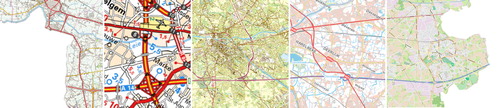
In conventional mapping practices, a motorway is usually conceived, perceived and most often mapped as an alien element superimposed on the territory. By symbolizing the first E-roads in a bright red, Belgian topographic maps have reflected their infrastructural dominance over the railway network, which was attributed a neutral black from then on (: CitationNational Geographic Institute, 1979). This way of symbolizing motorways is most reminiscent of, and still persists in, the cartographic logic of the roadmap (: CitationViamichelin, 2015): the strong and isolating red emphasizes their importance as major transport arteries, stressing their hierarchical superiority and efficiency. Later editions of the national topographic map have softened this red to a less authoritative magenta or a more subtle purple. The vivid magenta used in the 1997 series (: CitationNational Geographic Institute, 1997) still makes the motorway stand out clearly against other landscape features, depicted in blending greens and browns. The subdued purple featured in the most recent edition (: CitationNational Geographic Institute, 2014) somehow softens the status of the motorway as a clear-cut isolated object. Present-day editions of the Ordnance Survey Landranger maps (CitationOrdnance Survey, 2013) and the crowd-sourced online map application OpenStreetMap (: CitationOpenStreetMap, 2015) display a more radical shift in motorway symbolization: they picture the motorways in blue, stressing their affinity with the natural landscape features.
Figure 1. Collage of conventional maps covering the same area as E17 Motorway Landscapes, from left to right: CitationNational Geographic Institute (1979), ©NGI/IGN), CitationViamichelin (2015, ©Viamichelin), CitationNational Geographic Institute (1997, ©NGI/IGN), CitationNational Geographic Institute (2014, ©NGI/IGN) and CitationOpenStreetMap (2015, ©OpenStreetMap contributors).
2. Alternative modes of selection, generalization, symbolization and labelling: modifying cartographic procedures as a way to start shifting spatial epistemologies
E17 Motorway Landscapes (Main Map) takes this recent trend of imagining motorways not as disconnected from but as part of the landscape, a step further. To be able – at least partially – to break free from settled cartographic orthodoxies, the re-mapping of the motorway follows three specific strategies of cartographic exploration. First of all, the landscape is de- and recomposed following a relational rather than a topographic logic, revealing alternative measures of rhythm and of scale. Second, by incorporating the previous state of the selected elements and by furthermore stressing their transformation in relation to the E17, the motorway landscape is mapped as a process. Lastly, the symbolization of the map is designed to promote the reconception of the motorway landscape as a thick, albeit fragmented body rather than stressing the nature–culture dichotomy. Not only have the cartographic procedures of selection, generalization, symbolization been modified in order to be able to start reimagining the motorway as a motorway landscape: the absence of conventional labels on the proposed map is a conscious effort at shaking map-readers' automated mechanisms of framing.
2.1. Selection and generalization following a relational rationale: revealing alternative measures of rhythm and scale
E17 Motorway Landscapes (Main Map) explores the interactions between the motorway and various other spatial systems present on the site. This exploration is performed by means of a decomposition of the topographic map into a series of five component maps analysing the interaction of the E17 motorway with topography (Main Map component map 5) and hydrology (Main Map component map 4), national (Main Map component map 1) and local road networks (Main Map, component map 2) and the land-use patterns in its vicinity (Main Map, component map 3). The selection of elements is based on observed spatial relations. As such, each of the five maps explores the interplay of the E17 motorway and any of these other spatial structures (topography, hydrology, national and local roads and land-use patterns). This logic is reflected in the layout of the legend. Furthermore, generalization of the selected elements was performed in accordance with observed patterns of interaction rather than following a scalar logic. These patterns of interaction often pierce through the nested hierarchy of scales that has become a standard of topographic cartography. By rethinking the process of generalization according to that observation, patterns of interactions that cross scalar boundaries or that play at a variety of different scale levels, no longer remain hidden, but rather make up the map.
A cartographic assemblage of these interplays is constructed by means of a recomposition of the five component maps (Main Map, composite map). This recomposition reveals an even more complex polyphony of patterns, displaying the plurality of scales and of modes of interrelations between the motorway and the other landscape features, as well as the additional interactions between them. As such, the recomposition reveals alternative, interrelational, measures of scale and describes the rhythmic qualities of the newly created motorway landscape.
2.2. Incorporating previous states of mapped elements: reformulating landscape as a process
By also incorporating the previous states of selected elements, instead of mapping only their current spatial manifestation, the depiction of space is released from the timeframe of the snapshot; time itself becomes part of the map. By furthermore compiling a legend that classifies these elements according to their observed behaviour (for example, grouping into categories those elements that have been subdued to distinct types of transformations or grouping into a category those elements that have long remained unaltered) patterns of change become visible on the maps' surface. Processing the elements as such articulates the instability of space. Applying this strategy to the re-cartography of the E17 (Main Map), the motorway landscape is captured as a process, as being constantly in the making.
2.3. Attuning symbolization according to relationality: reconceiving the motorway landscape as a thick body
The design of a symbolization scheme, apart from selectively giving weight to certain objects, is usually aimed at facilitating the discrimination between element categories while at the same time making the kinship among different subgroups within one category recognizable at first glance. Moreover, cartographers often apply predefined symbolization schemes or else follow an established tradition, thereby leaving the particular site, context or the specific phenomena that are being mapped, out of consideration. These established symbolization schemes typically attribute a variety of reds – red, orange, pink, purple or yellow – to roads and a variety of greens to elements pertaining to ‘nature’ (). The contrasting effect brought about by this kind of stereotypical symbolization scheme perpetuates the nature–culture dichotomy and reinforces a layered conception of space, breaking apart the landscape into various predefined and easily discernible pieces.
The symbolization put forward in E17 Motorway Landscapes (Main Map) is designed to promote the reconception of the motorway landscape as a thick, albeit fragmented body. Where possible, colours were chosen to reflect attunement and relationality between different object categories. For example, the gradients of green attributed to topography reflect both its close connection to the water body (gradients of blue) as well as its influence on the location of the motorway (in yellow) (Main Map component map 5), bridges over the motorway are attributed an excessively fat red line to underline their rhythmic qualities (Main Map component map 2). These small adaptations of the symbolization are attempts to lift at least some of the long enduring dichotomies that hijack urbanism's ability to constructively engage in the making of place (CitationCorboz, 1983). Obviously, dichotomies such as the nature–culture divide remain strenuously persistent.
2.4. Omitting traditional labelling: hindering easy framing of the re-cartography within well-established cartographic and spatial schemes
The traditional labelling system based on place names has been replaced by a combined labelling/scaling system based on the kilometre markers flanking the motorway. The omission of traditional labels on the proposed map is a conscious effort at shaking the map-reader's mechanism of map-orientation and classification. This mechanism is typically based on the recognition of distinct entities that belong to stereotypical spatial categories (a specific city, a river) and is strongly supported by symbolization and labelling. Indicative symbolization and recognizable labels allow a map-reader to frame a new map against or within a personal set of reference maps and to interpret its context in relation to reference spatial concepts, built up through experience. The absence of human-imposed labels hampers this process of framing, and as a consequence hinders the reader from easily resorting to well-established schemes when interpreting the map's content. We hope that this difficulty to relate the map to previously acquired schemes will stimulate the map-reader to try out novel schemes of orientation and interpretation of space. We are aware that this strategy is very demanding of the reader, especially in a culture relying on fast and easy access to facilitate smooth consumption. For those completely unfamiliar with the context, a reference bar has been included at the bottom of the map sheet.
3. Discussion: agency of E17 motorway landscapes as a critical and projective landscape project
Of undisputed value for the documentation of the landscape, topographic maps have long functioned as the base layer for urban design. While their standardized cartographic procedures certainly guarantee their comprehensibility and employability as well as grant them an aura of objectivity, they are also an accessory to the perseverance of a rigid image of space: topographic maps reproduce our environments, as static, hierarchic, ultra-layered as well as fragmented, dichotomist spaces. Experiments with alternative cartographic forms challenge standardized ways of mapping and of making place. They construct alternatives and deconstruct orthodoxies (CitationCattoor & Perkins, 2014). E17 Motorway Landscapes (Main Map) alters conventional procedures of element selection, generalization and symbolization, tries out different ways of labelling and experiments with rules of scaling that deviate substantially from classic topographic map production. The tweaking of these standardized procedures allows us to begin reformulating the motorway space as a dynamic landscape, characterized by the interplay of a wide variety of spatial entities that cross the commonly adopted nested hierarchy of scales and that partially resolve stereotypical spatial dichotomies, such as the nature–culture divide.
But E17 Motorway Landscapes (Main Map) aims to be more than an analytic endeavour. Though the map for a large part constructs an alternative spatial history, the commitment of the authors is with the future of the region. In fact, the re-cartography was set up in close collaboration with Leiedal, the intergovernmental planning agency, out of concern about the ongoing deterioration of the regional landscape. Experimenting with novel ways to envision our environments stimulates the rediscovery of potentials inherent in the landscape which have often been overwritten by conventional cartographic procedures. E17 Motorway Landscapes (Main Map) highlights the plurality, dynamism and formal quality of the different metamorphoses that culminate in the present-day motorway landscape, engendering the capacity of this landscape as a productive ‘multiplicity constituted by heterogeneous terms and which establishes liaisons, relations between them’ (CitationDeleuze & Parnet, 2007, p. 52). Next to reimagining the dual carriageway as a thick, continuously evolving, but resilient, motorway landscape, E17 Motorway Landscapes (Main Map) attempts to formulate a partial cartographic answer to concrete, context-specific spatial challenges, such as the critical decline in the groundwater level, conflicting spatial claims mostly provoked by the particular location of the E17 in the midst of the river valley, local transport problems and the rapidly vanishing qualities of the surrounding landscape, which is overgrown by seemingly uncontrolled sprawled development. Since its development, E17 Motorway Landscapes (Main Map) has inspired a series of workshops set up around these spatial challenges. In these cases, the re-cartography has stimulated and facilitated an integrative and processual design approach, interweaving the hard and soft, the functional and the formal, the small and the large, as well as the past and the future state of the site (for an elaboration see CitationCattoor, 2015; CitationCattoor & De Meulder, 2010).
Software
The maps are compiled with Adobe Illustrator CS4. The map could not be generated through automated data processing. Therefore, data processing was performed manually, through visual comparison and assessment of historical sources and contemporary observations in the field.
A RELATIONAL AND PROCESSUAL RE-CARTOGRAPHY OF INFRASTRUCTURE: E17 Motorway Landscapes.
Download PDF (10.8 MB)Acknowledgments
The authors want to thank Mike Smith, Juliane Cron, Michael Siegel, Janet Mersey and Mark Zuidgeest, the journal editors and reviewers of this article, for their very valuable comments and suggestions. E17 Motorway Landscapes is a cartographic exploration concluding a workshop that was co-produced by Leiedal, an intermunicipal organization active in the south of West Flanders, and OSA/RUA, the research group of urbanism and architecture at the University of Leuven. Kaat Boon, Sofie Bullynck, Viviana d'Auria, Michiel Dehaene, Guido Geenen, Maarten Ghysen, David Hammerman, Jiri Klocka, Michael Rudolph, Marjan Sansen, Gunther Slagmeulders, Karin Thomsen, Hans Teerds, Liesl Vanautgaerden and Tania Vandenbroucke participated in this design workshop. We are foremost indebted to the intermunicipal organization Leiedal, and especially to its former director Karel Debaere.
Disclosure statement
No potential conflict of interest was reported by the authors.
Related Research Data
References
- Cattoor, B. ( in press). Designerly mapping practices at the crossroads of cartography and urbanism: A processual account of three re-cartographies of southwest flanders. Environment and Planning A.
- Cattoor, B., & De Meulder, B. (2010). Iteration between collaborative urbanism and formal cartographies: Design experiments in southwest Flanders. In N. Meijsmans (Ed.), Designing for a region (pp. 202–213). Amsterdam: SUN.
- Cattoor, B., Louwette, T., & Thomsen, K. (2013). Published Map. In CATTOOR B., 2013. Chronologies of a (sub)urbanized territory: Reimagining (sub)urbanization processes in southwest Flanders, Belgium. Journal of Maps, 9(1), 76–83. doi: 10.1080/17445647.2013.770972
- Cattoor, B., & Perkins, C. (2014). Re-cartographies of landscape: New narratives in architectural atlases. The Cartographic Journal, 51(2), 166–178. doi: 10.1179/1743277413Y.0000000076
- Corboz, A. (1983). The land as palimpsest. Diogenes, 31(121), 12–34. doi: 10.1177/039219218303112102
- Deleuze, G., & Parnet, C. Deleuze. (2007). Dialogues II. New York, NY: Columbia University Press.
- National Geographic Institute. (1979). Topografische kaart van België [topographic map series]. Ed1. 1:50.000. Brussels: NGI/IGN.S
- National Geographic Institute. (1997). Topografische kaart van België [Topographic map series]. 1/10.000. Retrieved May 1, 2015, from http://www.ngi.be/topomapviewer/public. NGI topomapviewer.
- National Geographic Institute. (2014). Provinciekaarten [topographic map series]. 1/100.000. Available through: NGI topomapviewer . Retrieved May 1, 2015 from http://www.ngi.be/topomapviewer/public.
- Openstreetmap. (2015). Waregem 50.8905,3.4303 [Map extracted from online map application]. Standard layers, no scale specified. Retrieved May 1, 2015 from https://www.openstreetmap.org.
- Ordnance Survey. (2013). Published Map. OS Landranger Map Series Ed. D2. Scale of the original map series: 1/50.000. Southampton: Ordnance Survey.
- Viamichelin. (2015). Marke 50.8051,3.2100 [Map extracted from online map application]. Standard layers, no scale specified. Retrieved May 1, 2015 from http://www.viamichelin.com.