ABSTRACT
In this paper, we present the first complete morphological map of the Salina offshore at a scale of 1:100,000. The submarine flanks of the Salina edifice extend down to −650 to −1300 m, are steep and characterized by an uneven morphology due to the presence of volcanic and erosive-depositional features. The volcanic features cover ∼30% of the submarine portion and include volcanic cones and bedrock outcrops. The remaining ∼70% is affected by a wide series of erosive-depositional features. Among these, features related to Late Quaternary sea level fluctuations comprise the insular shelf surrounding the island and overlying submarine terraced depositional sequences. Mass-wasting features include landslide scars, channels, fan-shaped deposits and waveforms. The presented map provides useful insights for a better understanding of the morphological evolution of the edifice
1. Introduction
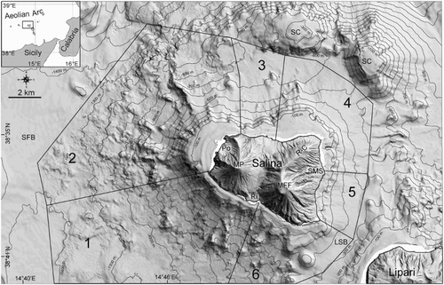
Salina Island is located in the center of the Aeolian Arc, at the intersection between the arc-shaped structure of the archipelago and the NNW–SSE elongated Salina–Lipari–Vulcano volcanic belt ( inset). This alignment is related to the occurrence of a main strike-slip NNW–SSE regional fault, interpreted as the offshore prolongation of the ‘Tindari–Letojanni’ fault, recognized onland in northeastern Sicily (e.g. CitationVentura, 2013 and reference therein). The volcanological evolution of Salina Island was recently summarized by CitationLucchi et al. (2013), documenting subaerial volcanism between ∼244 and 15.6 ka through 6 Eruptive Epochs. A general E–W migration of active vents, controlled primarily by the dominant NNW–SSE and subordinate NE–SW regional tectonic trends, was recognized, as well as a progressive chemical differentiation of the erupted products from calc-alkaline basalts to rhyolites (CitationLucchi et al., 2013). Previous studies of the submarine areas (CitationRomagnoli, Casalbore, Bortoluzzi et al., 2013) have shown that the island, the highest (962 m) in the Aeolian Archipelago, represents only the subaerial culmination (∼16%) of a large volcanic complex that reaches −1300 m.
Figure 1. Shaded relief map of Salina edifice (light direction from NE, isobaths every 100 m). Notes: Black polygons show the sectors where slope graphs were computed (). SMS: Santa Marina Salina, Ri: Rinella, Po: Pollara, R-C: Rivi-Capo volcano, MFF: Monte Fossa delle Felci, MP: Monte Porri, LSB: Lipari–Salina Basin, SFB: Salina–Filicudi Basin, SC: Secca del Capo.

The aim of this paper is to provide the first bathy-morphological map of Salina Island offshore at 1:100,000 scale through the analysis of an accurate and high-resolution Digital Elevation Model (DEM). The study allows us to better constrain the geological processes that led to the present-day morphology of the submarine volcanic edifice, and also provides useful information on the main geohazard features related to the recent evolution of the submarine flanks of Salina volcano.
2. Data and methods
Multibeam bathymetric data on the submarine portions of Salina Island have been acquired since 2001 by CNR-IGAG, University of Rome (Sapienza) and University of Bologna mainly aboard the research vessels Urania and Thetis (CNR), while smaller boats were used to survey the near shore area. To obtain the optimal resolution at each bathymetric range, different multibeam systems operating at different frequencies (from 50 to 400 kHz) were employed. All the collected data were DGPS-positioned and processed using Caris Hips&Sips 8.1.7. The processing workflow encompassed corrections for the effects of tide, patch test (roll, pitch, yaw and time delay) and sound velocity variations in the water column (CitationBosman et al., 2015). Manual editing and automated filters were used to remove noise and spikes on bathymetric data or soundings in order to obtain high-resolution DEMs with cell-size variable from 1 m in shallow water ( < 100 m depth) to 25 m at over −1300 m. A final DEM at 25 m grid cell-size was used for the production of the bathymetric and morphological maps presented ( and Main Map); however the interpretation of features was made on data at the maximum possible resolution.
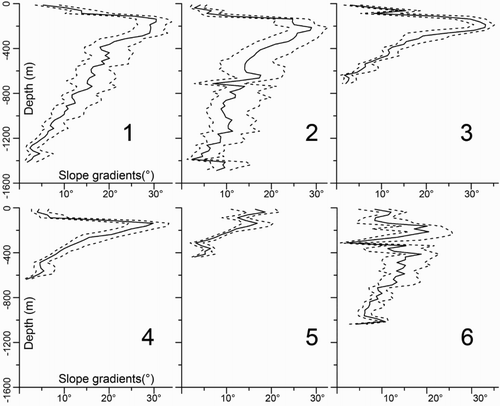
The slope map of the Salina offshore (see Main Map) was computed from the DEM by considering the direction of steepest descent or ascent at each grid point. Graphs of median and inter-quartile range of cumulative surface slope values according to CitationMitchell, Masson, Watts, Gee, and Urgeles (2002) were also produced () to analyze the average steepness and slope variability versus depth in the different sectors of the Salina offshore.
Figure 2. Slope graphs of the submarine flanks of Salina calculated according to CitationMitchell et al. (2002). Notes: Slope values within each sector (see for location) were sorted according to depth intervals of 25 m, and a slope cumulative distribution was calculated for each depth interval. Continuous line indicates the 50% percentile (median) of the distribution, while dash line is used for 25% and 75%.

3. Geomorphological map of Salina offshore
The base of the Salina edifice is located at depths ranging between −650 and −1300 m, with the exception for the SE sector where a saddle at about −300 m connects Salina to Lipari (Lipari–Salina Basin, LSB in ). To the W, a saddle at about −1370 m separates Salina from the Filicudi volcanic edifice (Salina–Filicudi Basin, SFB in ). To the N and NE of Salina, a small basin (North Salina Basin, NSB in ) is delimited by Secca del Capo (SC in ), a submarine high characterized by the presence of two cones with flat-top shapes, that rise to −250 m (the western) and −27 m (the eastern). The submarine flanks of Salina are steep, with slope values of 28° to 35° in the shallower sectors, decreasing to a few degrees at the base of the edifice (). Relatively low slope values are also present in the first −100 to −200 m (upper part of graphs in ), where the occurrence of an insular shelf (IS) markedly interrupts the morphological continuity between the subaerial and submarine flanks ( and ).
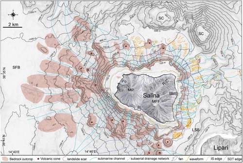
Figure 3. Morphological map of Salina offshore, showing the main volcanic and erosive-depositional features; acronyms as in .

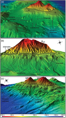
Figure 4. 3-D perspective view (vertical exaggeration 1.5×) of the northern (a), eastern (b) and southern flank (c) of Salina, where the main volcanic and erosive-depositional features are indicated. Notes: Dashed black line indicates the coastline. IS: insular shelf; other acronyms as in . Shallow-water gaps on multibeam data were filled up to improve readability of the images.

At greater depths, two main different types of slope patterns can be identified (): the first type is mostly found in the W and S part of the edifice (Sectors 1 and 2 in ) and is defined by a large variability in slope values, similarly to that observed for constructional volcanic flanks in nearby Lipari (CitationCasalbore, Bosman, Romagnoli, Di Filippo, & Chiocci, 2014), Vulcano (CitationRomagnoli, Casalbore, Bosman, Braga, & Chiocci, 2013) and Stromboli islands (CitationCasalbore, Romagnoli, Chiocci, & Frezza, 2010). The second type is mostly found in the E and NE part of the edifice (Sectors 3, 4 and 5 in ) and is defined by a narrower distribution of slope values, decreasing linearly with depth (the base of these flanks do not reach high depth, ). This slope pattern is similar to that observed over submarine flanks of Lipari, Vulcano and Stromboli edifices that were ‘smoothed’ by the emplacement of significant mass-wasting deposits (CitationCasalbore et al., 2010; CitationCasalbore, Bosman, Romagnoli, Di Filippo et al., 2014; CitationRomagnoli, Casalbore, Bosman et al., 2013). Finally, a very peculiar distribution characterizes Sector 6 ( and ), where slope values do not linearly change with depth, thus reflecting the presence of steeper segments alternating with two, more gently dipping areas located at different depths, and corresponding to the IS and the Lipari–Salina Basin, respectively.
A synthetic description of the main geomorphological features of the Salina edifice ( and Main Map) is presented below.
3.1. Volcanic morphologies
A large number of volcanic features crop out offshore Salina Island, mostly in the western sector, covering about the 30% of the whole submarine edifice and accounting for ∼70 km2 (light-brown areas in ). In detail, two main volcanic morphologies can be identified: volcanic cones and bedrock outcrops ().
Volcanic cones are positive morphological features, with sub-conical shapes. They are mainly found between −180 and −1000 m in the western, northern and southern sectors of the edifice where they often represent the summit of radial volcanic features (). Volcanic cones have heights of 50–180 m with respect to the surrounding seafloor and diameters of 650–1.5 km, covering areas of 0.1–1 km2 each one. Cones show pointy-shaped tops, with an exception for a flat-topped cone located in the Lipari–Salina Basin, with its summit located around −180 m; the height/width ratio of the cones ranges between 0.1 and 0.2.
Bedrock outcrops are morphological highs with variable shape; they are generally oriented in a radial direction with respect to the island summit and are often marked by a degraded morphology due to post-eruptive and/or erosive-depositional processes. For this reason, they are interpreted as erosional remnants carved in the bedrock by marine erosive activity. Some of them are located near to the coast, in morphologic continuation with subaerial structures. However, at depths shallower than −200 m, their summit is cut by the development of the IS. Other bedrock outcrops occur as isolated morphological highs, sometimes with large extensions, as in the W offshore of Salina ().
3.2. Erosive-depositional features
The mapped erosive-depositional features can be divided into two main types: (1) features related to Late Quaternary sea level fluctuations, including IS and overlying Submarine Depositional Terrace (SDT in ); (2) features related to mass-wasting processes, including landslide scars, channels and gullies, depositional fans and waveforms.
The IS ( and ) can be considered an erosional submerged surface extending from the coastline to the lowest level of wave erosion during glacial stages (CitationTrenhaile, 2001). The insular shelf is well-developed all around Salina Island, except for the eastern sector of the edifice, where it is narrow and strongly incised by a dense channel network (e.g. ). The shelf shows a maximum width of 1.6–1.7 km in the NE and NW sectors of the edifice and its outer edge is located at depths ranging from −100 to −200 m. As the shelf is produced or reworked by wave erosion during the Last Glacial Maximum (and possibly previous sea level low stands), its presence indicates an age older than 20,000 years for related volcanic units. Moreover, because the shelf width in a volcanic island setting tends to increase with exposure to wave action through time, its size can be used as a proxy for the relative age of a specific sector (CitationQuartau et al., 2014 and reference therein).
The insular shelf is commonly overlaid by SDTs (), that is (commonly prograding), sedimentary wedges from the coast to the shelf edge, trending parallel to the shore. Their formation occurred during the Last Glacial Maximum or during successive sea level rise (e.g. CitationChiocci & Orlando, 1996; CitationChiocci & Romagnoli, 2004; CitationQuartau et al., 2012). In detail, three main orders of overlying depositional terraces were identified on the insular shelf of Salina, with outer edges located at depth ranges of −10 to −20 m; −40 to −60 m and −100 to −120 m.
Landslide scars with widths of 10/100s m are observed at the outer edge of the insular shelf and overlying SDTs (); in contrast, large-scale landslide scars or deposits are scarcely observed along the flanks of Salina. In a few cases, coaxial landslide scars are observed at greater depths, thus suggesting the occurrence of mass-wasting processes with retrogressive evolution.
Channelized features largely vary in size, from some 100s m long and narrow gullies in the upper part of flanks up to some kilometers-long channels downslope ( and ). Most of these channels develop at the shelf edge or below it, acting as an erosional base level for gravity flows coming from gullies in the upper slope. In some cases, the emplacement of a channel network results in a strong indent of the insular shelf; the channel's head extend up to water depths of 10s m, several 100s m far from the coast. These features occur mainly on the E flank of Salina, but they are also present in the SW flank. In some cases, a morphological link between subaerial creeks and submarine channels is evident, highlighting the key role likely played by hyperpycnal flows in the formation and development of these submarine channels, as already reported in other volcanic (e.g. CitationBabonneau et al., 2013; CitationRomagnoli, Casalbore, & Chiocci, 2012) and tectonically controlled continental margins (e.g. CitationCasalbore, Chiocci, Scarascia Mugnozza, Tommasi, & Sposato, 2011; CitationChiocci & Casalbore, 2011). The morphological evolution of these submarine features should be carefully monitored, as they might represent a future marine geohazard due to their retrogressive evolution and proximity to the coastline.
Fan-shaped deposits are often recognized at the foot of channelized features (particularly on the E flank of Salina; (b)), ranging in width from 100s m to several kilometers. The development of the fans is always related to a marked decrease in slope values at the base of the submarine flanks, similar to that observed at Stromboli, Vulcano and Lipari volcanoes (CitationCasalbore et al., 2010; CitationCasalbore, Bosman, Romagnoli, Di Filippo et al., 2014; CitationRomagnoli et al., 2012). Their smoothed morphology suggests that they are due to a continuous feeding of eroded debris rather than to catastrophic mass-wasting episodes (i.e. debris avalanche).
Seafloor waveforms are observed both within the floor of channelized features and on the fan-shaped features developed in the northern and eastern flanks of Salina ( and ). An example is shown in (a), where the waveforms affect the seafloor morphology of a 1 km-wide channel located between −400 and −660 m, in correspondence with a slope decreasing to less than 9°. These waveforms have a wavelength of 70–150 m, a wave height of 3–7 m and a lateral extent of 80–160 m; they show arcuate shape in plan-view and are downslope asymmetric in cross-section, with lee side sloping up to 16° (see also CitationCasalbore et al., 2013). On the eastern flank of Salina, waveforms are widespread both on the floor of channels and on underlying fan-shaped deposits ((b)); they have a wavelength of 70–150 m, a wave height of 3–7 m, and a lateral extent of 80–160 m. Similar to the previous example, waveforms show arcuate or crescentic shape in plan-view and are downslope asymmetric in cross-section, with lee side slopes up to 25°. Based on their morphologic similarities with crescent-shaped bedforms observed within active canyons and related fan-shaped deposits (CitationCasalbore, Bosman, Romagnoli, & Chiocci, 2014; CitationCartigny, Postma, Van den Berg, & Mastbergen, 2011; CitationConway, Barrie, Picard, & Bornhold, 2012; CitationPaull et al., 2010), these features can be interpreted as cyclic steps, that is, a class of slowly upslope migrating turbiditic sediment waves, where each downward step is bounded by a hydraulic jump (CitationKostic, 2011 and reference therein).
4. Conclusions
The map presented in this work shows the main morphological features characterizing the submarine portions of Salina edifice. Data analysis helps to better understand how the morphologic evolution was controlled by the complex interplay between primary volcanic and erosive-depositional processes, the latter ones also modulated by Late Quaternary sea level fluctuations.
On the whole, a marked morphologic difference between the western submarine part of Salina with respect to the eastern part can be envisaged. The western and southwestern flanks are morphologically dominated by volcanic features, representing part of a larger volcanic belt flanking the western side of the Lipari–Vulcano–Salina volcanic alignment and considered to represent an earlier stage of volcanic development in the Central Aeolian sector (CitationRomagnoli, Calanchi, Gabbianelli, Lanzafame, & Rossi, 1989). In contrast, the northeastern and eastern flanks are dominated by erosive-depositional features, such as channels, fan-shaped deposits and widespread crescent-shaped waveforms. Large-scale instability processes are not common, whereas minor landsliding processes were mapped at the edge of the insular shelf and overlying deposits. This setting is similar to that observed at other Aeolian volcanic islands (CitationRomagnoli, Casalbore, Bortoluzzi et al., 2013), with the exception of the Stromboli edifice where large sector collapses and related debris avalanches were recognized (CitationRomagnoli, Casalbore, Chiocci, & Bosman, 2009; CitationRomagnoli, Kokelaar, Casalbore, & Chiocci, 2009).
Software
Caris Hips&Sips 8.1.7 was used to process multibeam data and to generate the marine DTM, while Global Mapper 15 was used to visualize data using shaded relief maps, contour maps and slope gradient maps in order to perform morphological analyses, and extract morphological features from the DTM. The design of the final map was performed using Adobe Illustrator.
Morphology of Salina Offshore (Southern Tyrrhenian Sea)
Download PDF (54 MB)Acknowledgements
Officials and crews of R/V Urania and Thetis are acknowledged along with the researchers and students taking part in the surveys. Special thanks are due to Cristian Montanaro, who helped in the mapping of the morphological features offshore Salina Island and Andre Fascetti for data processing. We also thank P. Baldi for the terrestrial DEMs of the islands, that were produced by the reprocessing of Regional Cartographic Services data and ad hoc aerial photogrammetry provided by University of Bologna. We gratefully acknowledge Giedrė Beconytė, Leonardo Macelloni and Salvatore Passaro for their useful suggestions that improve the quality of the paper.
Disclosure statement
No potential conflict of interest was reported by the authors.
Funding
This research was funded by the National MaGIC Project (Marine Geohazards along the Italian Coasts, www.magicproject.it) and carried out in the framework of RITMARE (Ricerca ITaliana per il MARE) Project.
References
- Babonneau, N., Delacourt, C., Cancouët, R., Sisavath, E., Bachèlery, P., Mazuel, A., … Villeneuve N. (2013). Direct sediment transfer from land to deep-sea: Insights into shallow multibeam bathymetry at La Réunion Island. Marine Geology, 346, 47–57. doi: 10.1016/j.margeo.2013.08.006
- Bosman A., Casalbore D., Anzidei M., Muccini F., Carmisciano C., & Chiocci F. L. (2015). The first ultra-high resolution marine digital terrain model of the shallow-water sector around Lipari Island (Aeolian archipelago, Italy). Annals of Geophysics, 58(2), S0218. doi:10.4401/ag-6746
- Cartigny, M. J. B., Postma, G., Van den Berg, J. H., & Mastbergen, D. R. (2011). A comparative study of sediment waves and cyclic steps based on geometries, internal structures and numerical modelling. Marine Geology, 280, 40–56. doi: 10.1016/j.margeo.2010.11.006
- Casalbore, D., Bosman, A., Romagnoli, C., & Chiocci, F. L. (2013). Small-scale crescent-shaped bedforms in submarine volcanic setting: Examples from Stromboli and Salina Island (Italy). GeoActa, 12, 37–45.
- Casalbore, D., Bosman, A., Romagnoli, C., & Chiocci, F. L. (2014). Large-scale seafloor waveforms on the flanks of insular volcanoes (Aeolian Archipelago, Italy), with inferences about their origin. Marine Geology, 355, 318–329. doi: 10.1016/j.margeo.2014.06.007
- Casalbore, D., Bosman, A., Romagnoli, C., Di Filippo, M., & Chiocci, F. L. (2014). Morphology of Lipari offshore (Southern Tyrrhenian Sea). Journal of Maps, 1–10. doi:10.1080/17445647.2014.980858
- Casalbore, D., Chiocci, F. L., Scarascia Mugnozza, G., Tommasi, P., & Sposato, A. (2011). Flash-flood hyperpycnal flows generating shallow-water landslides at Fiumara mouths in Western Messina Straits (Italy). Marine Geophysical. Research, 32(1–2), 257–271. doi: 10.1007/s11001-011-9128-y
- Casalbore, D., Romagnoli, C., Chiocci, F., & Frezza, V. (2010). Morphosedimentary characteristics of the volcanic apron around Stromboli volcano. Marine Geology, 269, 132–148. doi: 10.1016/j.margeo.2010.01.004
- Chiocci, F. L., & Casalbore, D. (2011). Submarine gullies on Italian upper slopes and their relationship with volcanic activity revisited 20 years after Bill Normark's pioneering work. Geopshere, 7, 1284–1293.
- Chiocci, F. L., & Orlando L. (1996). Lowstand terraces on Tyrrhenian Sea steep continental slopes. Marine Geology, 134, 127–143. doi: 10.1016/0025-3227(96)00023-0
- Chiocci, F. L., & Romagnoli, C. (2004). Terrazzi deposizionali sommersi nelle Isole Eolie. Memorie Descrittive Della Carta Geologica d’ Italia, 58, 81–114.
- Conway, K. W., Barrie, J. V., Picard, K., & Bornhold, B. D. (2012). Submarine channel evolution: Active channels in fjords, British Columbia, Canada. Geo-Marine Letters, 32, 301–312. doi: 10.1007/s00367-012-0280-4
- Kostic, S. (2011). Modeling of submarine cyclic steps: Controls on their formation, migration and architecture. Geosphere, 7, 294–304. doi: 10.1130/GES00601.1
- Lucchi, F., Gertisser, R., Keller, J., Forni, F., De Astis, G., & Tranne, C. A. (2013). Eruptive history and magmatic evolution of the Island of Salina (central Aeolian archipelago). In F. Lucchi, A. Peccerillo, J. Keller, C. A. Tranne, & P. L. Rossi (Eds.), The Aeolian Islands volcanoes. London: Memoirs Geological Society, 37, 155–211.
- Mitchell, N. C., Masson, D. G., Watts, A. B., Gee, M. J. R., & Urgeles, R. (2002). The morphology of the submarine flanks of volcanic ocean Islands. A comparative study of the Canary and Hawaiian hotspot Islands. Journal of Volcanology and Geothermal. Research, 115, 83–107. doi: 10.1016/S0377-0273(01)00310-9
- Paull, C. K., Ussler III, W., Caress, D. W., Lundsten, E., Covault, J. A., Maier, K. L., … Augenstein, S. (2010). Origins of large crescent-shaped bedforms within the axial channel of Monterey Canyon. Geosphere, 6, 755–774. doi: 10.1130/GES00527.1
- Quartau, R., Hipólito, A., Romagnoli, C., Casalbore, D., Madeira, J., Tempera, F., … Chiocci, F. L. (2014). The morphology of insular shelves as a key for understanding the geological evolution of volcanic islands: Insights from Terceira Island (Azores). Geochemistry, Geophysics, Geosystems, 15, 1801–1826. doi: 10.1002/2014GC005248
- Quartau, R., Tempera, F., Mitchell, N. C., Pinheiro, L. M., Duarte, H., Bates, R., … Monteiro, J. H. (2012). Morphology of the Faial Island shelf (Azores): The interplay between volcanic, erosional, depositional and mass-wasting processes. Geochemistry, Geophysics, Geosystems, 13(4), 30. doi:10.1029/2011GC003987
- Romagnoli, C., Calanchi, N., Gabbianelli, G., Lanzafame, G., & Rossi, P. L. (1989). Contributi delle ricerche di geologia marina alla caratterizzazione morfostrutturale ed evolutiva dei complessi vulcanici di Salina, Lipari e Vulcano (Isole Eolie). Bollettino Gruppo Nazionale Vulcanologia, 1982(2), 971–978.
- Romagnoli, C., Casalbore, D., Bortoluzzi G., Bosman A., Chiocci, F. L., D'Oriano, F., … Marani M. (2013). Bathy-morphological setting of the Aeolian Islands. In F. Lucchi, A. Peccerillo, J. Keller, C. A. Tranne, & P. L. Rossi (Eds.), The Aeolian Islands volcanoes (Vol. 37, pp., 27–36). London: Memoirs Geological Society.
- Romagnoli, C., Casalbore, D., Bosman, A., Braga, R., & Chiocci, F. L. (2013). Submarine structure of Vulcano volcano (Aeolian Islands) revealed by high-resolution bathymetry and seismo-acoustic data. Marine Geology, 338, 30–45. doi: 10.1016/j.margeo.2012.12.002
- Romagnoli, C., Casalbore, D., & Chiocci, F. L. (2012). La Fossa Caldera breaching and submarine erosion (Vulcano Island, Italy). Marine Geology, 303–306, 87–98. doi: 10.1016/j.margeo.2012.02.004
- Romagnoli, C., Casalbore, D., Chiocci, F. L., & Bosman, A. (2009). Offshore evidence of large-scale lateral collapses on the eastern flank of Stromboli, Italy, due to structurally-controlled, bilateral flank instability. Marine Geology, 262, 1–13. doi: 10.1016/j.margeo.2009.02.004
- Romagnoli, C., Kokelaar, P., Casalbore, D., & Chiocci, F. L. (2009). Lateral collapses and active sedimentary processes on the northwestern flank of Stromboli volcano, Italy. Marine Geology, 265, 101–119. doi: 10.1016/j.margeo.2009.06.013
- Trenhaile, A. S. (2001). Modelling the quaternary evolution of shore platforms and erosional continental shelves. Earth Surface Processes and Landforms, 26, 1103–1128. doi: 10.1002/esp.255
- Ventura, G. (2013). Kinematics of the Aeolian volcanism (Southern Tyrrhenian Sea) from geophysical and geological data. In F. Lucchi, A. Peccerillo, J. Keller, C. A. Tranne, & P. L. Rossi (Eds.), The Aeolian Islands volcanoes (Vol. 37, pp. 3–11). London: Memoirs Geological Society.
