
ABSTRACT
A 1:50,000 scale map of the surficial geology and geomorphology of the mountain glacier landsystem and the human impacts of the Kumtor Gold Mine operations in the Akshiirak massif was compiled from a 0.5 m resolution pan-sharpened image from Digital Globe's WorldView-2 platform dated 5 September 2014. The map depicts 11 surficial geology units, 6 of which are classified according to natural genetic origins and 5 relating to recent human interference with glaciological and land surface processes. When compared to historical imagery the map records a number of important, not unrelated, cryospheric responses to mining activity, including: (a) the triggering of human-induced glacier speed-up events or surges due to dumping of mine spoil on receding and thinning glacier snouts; (b) the reactivation by internal creep of buried glacier ice due to the expansion of spoil dumping onto down valley areas of ice-cored moraine; and (c) accelerated ice drawdown and significant incursions of ice into the mine pit walls due to the artificial removal of substantial areas of glacier ablation zones.
1. Introduction
Since 1997 the glacierised alpine terrain on the northwest corner of the Akshiirak massif of the Tien Shan Mountains of Kyrgyzstan has been the site of the Kumtor Gold Mine (CitationKronenberg, 2014), where a super quarry has been operated at an altitude of 4000 m asl. ( ). Deep excavations have been carried out over an area of ca. 4.5 km2 in some of the most severe environmental conditions for mining anywhere in the world, where the Petrov, Lysii, Davidov, Sarytor and Bordoo glaciers flow into deep mountain valleys from their high altitude cirque basins located at elevations above 4200 m asl. Unusually for such mining, the mine operators have had to excavate through glacier ice before accessing the bedrock (), initiating some unique engineering problems () and a full-scale experiment in debris loading-triggered glacier speed-up events (surges; CitationJamieson, Ewertowski, & Evans, 2015). Specifically, the mining process has necessitated the stockpiling of significant rock waste and quarried glacier ice on adjacent, undisturbed glacier surfaces and stagnant snouts. Waste dumping and land modification for mine infrastructure have affected an area of approximately 9.3 km2.
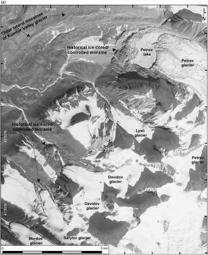
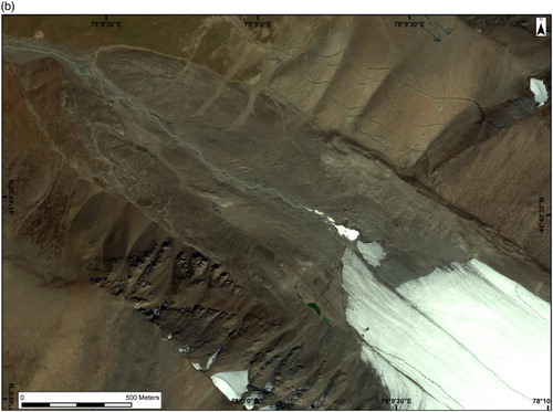
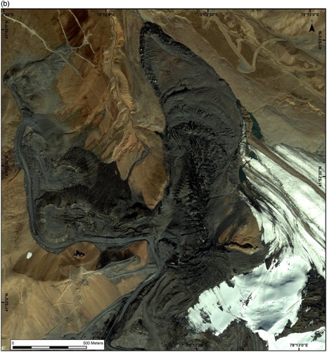
Figure 1. Annotated satellite images and location maps of the Kumtor Mine and the adjacent glaciers and glaciated terrain in 2014: (a) Landsat 8 platform image taken on 14 May 2014 (data available from the US Geological Survey) showing the Akshiirak glacierised massif within the Tien Shan mountains. The coverage of vertical aerial images in the following figures is demarcated; (b) local glaciers and landscape surrounding the mine viewed in a 1.8 m resolution image from Digital Globe's WorldView-2 platform (from CitationJamieson et al., 2015). The coverage and viewing direction (white arrow) of oblique aerial images in following figures are demarcated.
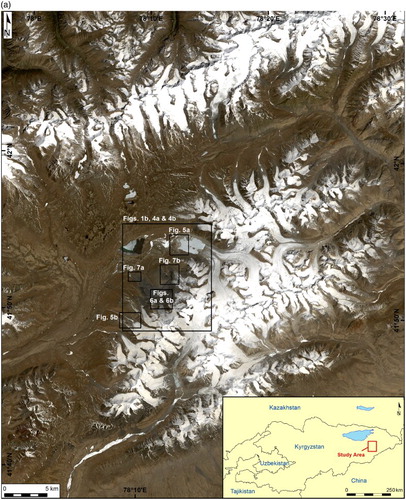
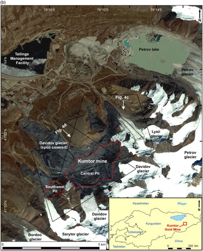
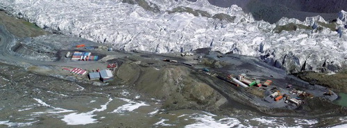
Figure 2. View southwards across the mine in June 2012, showing the alpine terrain and the appearance of glacier ice in the upper terraces on the pit wall where the Davidov Glacier is being excavated (image from CitationThalenhorst et al., 2012).
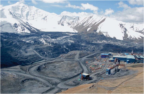
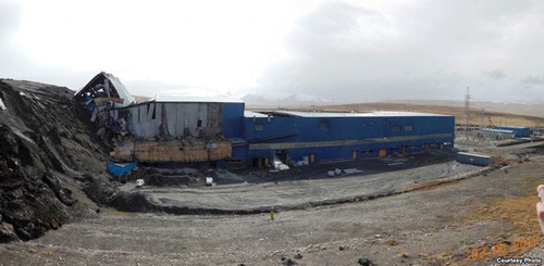
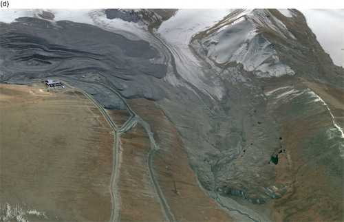
Figure 3. Mine infrastructure being bulldozed by permafrost creep below the Davidov Glacier mine dump in April 2013 (Bruce Pannier's Qishloq Ovozi blog).
The map presented here (Main Map) captures the state of the Kumtor Mine and surrounding glacierised alpine terrain in 2014, after 17 years of quarrying and waste dumping of both glacier ice and excavated rock material on permafrost that is characterised by significant areas of buried glacier (ground) ice. Regularly captured satellite images have enabled us to identify the first examples of human-triggered glacier speed-up events or surges, which have been just some of the cryospheric responses to mining disturbance since 1997 (CitationJamieson et al., 2015). The influence of this disturbance can be charted, and the pre-mining natural glacial landsystem signature determined, from historical satellite imagery and aerial photography (). The natural glacial landsystem comprises alpine style cirque and valley glaciers with polythermal snouts prone to occasional surging (CitationAizen, Kuzmichenok, Surazakov, & Aizen, 2006). Hence the glacial geomorphology is characterised by: (a) extensive areas of valley floor ice-cored moraine (including controlled moraine) derived from the melt out of englacial debris bands and/or the concentration of rock avalanche debris in the ablation zone; (b) fluted till surfaces that lie up-valley from ice-cored moraine and attest to sub-glacial deforming layers and hence temperate thermal conditions. The association of fluted till surfaces and ice-cored moraine arcs is diagnostic of polythermal snouts in other glacial settings such as Svalbard and the central uplands of Iceland. However, such a landform association would also not be unusual on the forelands of surging glaciers. Historical trends in glacier activity for the area are dominated by snout recession (CitationAizen et al., 2006; CitationAvsiuk, 1953; CitationBondarev, 1963; CitationDavydov, 1927; CitationDyurgerov, Liu, & Xie, 1995; CitationEngel, Sobr, & Yerokhin, 2012; CitationJansky et al., 2009; CitationKalesnik & Epstein, 1935; CitationKaulbars, 1875; CitationKuzmichenok, 1990; CitationSevast'yanov & Funtikov, 1981; CitationSolomina, Barry, & Bodnya, 2004), but a very small number of glaciers advanced during the twentieth century, predominantly it would appear through surging (CitationDolgushin & Osipova, 1982; CitationSolomina et al., 2004). In the area of the Kumtor Mine, the Davidov Glacier terminus advanced 240 m between 1964 and 1980 and aerial images indicate that the snout had developed a steepening and crevassed snout by 1977, indicating that a re-advance or potential surge was likely underway at that time. Imagery indicates that after 1977 and up until 2002 the glacier was in recession. The 2014 map presented here (Main Map) contains evidence of glacier and bedrock mining in alpine glacierised terrain, waste and ice dumping and cryospheric responses to such disturbances that include human-triggered glacier speed-up events (surges) and stagnant ice reactivation and permafrost creep.
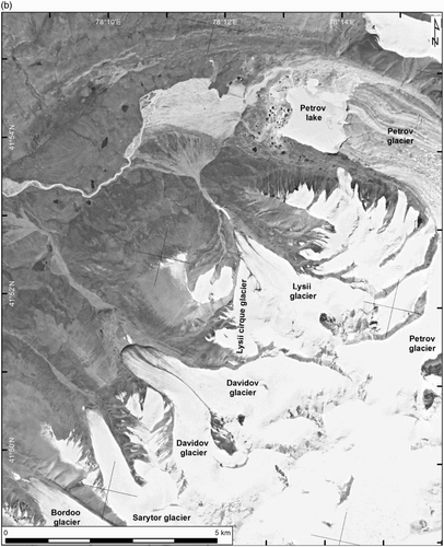
Figure 4. Pre- and post-mining imagery of the Akshiirak glaciers and surrounding terrain: (a) Corona image KH-4A (mission 1014–2) image dating back to 1964 and annotated to show main glacial landforms (data available from the US Geological Survey); (b) KH-9 image (mission 1216–5) dating back to 1980 and illustrating the relative stability of the glacier snouts, with the exception of the Petrov calving margin, when compared to the 1964 imagery (data available from the US Geological Survey). Note the Lysii Cirque Glacier prior to its covering with mining spoil; (c) oblique 2.4 m resolution Quickbird image of the Lysii cirque glacier front (300–350 m wide) in 2002 during the initial stages of its speed-up/surge in response to supraglacial mine waste dumping. Note that it has caused deformation of the Lysii Glacier snout; (d) oblique 2.4 m resolution Quickbird image of the Davidov Glacier snout in 2002 during the early stages of supraglacial mine waste dumping. Note the occurrence of ice-cored hummocky moraine in the lower valley comprising outer, brown coloured and inner, grey coloured zones, the latter containing more densely spaced linear ridges (controlled moraine, sensu CitationEvans, 2009).

2. Map production
The surficial geology and geomorphology map (Main Map) of the Kumtor Mine area of the Akshiirak massif was compiled from a 0.5 m resolution pan-sharpened image from Digital Globe's WorldView-2 platform dated 5 September 5 2014. Contours at 100 m intervals were derived from Advanced Spaceborne Thermal Emission and Reflection Radiometer (ASTER) Global Digital Elevation Model (GDEM) version 2, which is a product of METI and NASA (http://gdem.ersdac.jspacesystems.or.jp/). The GDEM data therefore represent a land surface that has since been modified by mine excavation and dumping. Accordingly, contours were excluded over the mine excavation site and large areas of spoil dumping because significant elevation changes had taken place in these areas since the ASTER GDEM generation. The map is produced in UTM 44N projection (EPSG code: 32644) with WGS 1984 datum. The Main Map is at a scale of 1:50,000 if printed in A0 paper size.
The base data for the geomorphology and surficial geology were compiled using the 2014 imagery on a coloured ink film overlay. The final map design and production were undertaken in Adobe Illustrator. A raster image was used for the glacier surfaces by extracting them directly from the satellite image and transposing a false blue colourised tint, allowing the display of features such as crevasses, snowlines and supraglacial debris patterns.
3. Surficial geology and geomorphology of the Kumtor Mine area
In addition to the cirque and valley glaciers and extensive bedrock outcrops, which occur mostly in the steeper mountain terrain as alpine summits and slopes, the Main Map is divided into 11 surficial geology units, 6 of which are classified according to natural genetic, predominantly glacial, origins and 5 relating to recent human interference with glaciological and land surface processes. The area is characterised by continuous mountain permafrost up to 250 m thick (CitationRedmond, Thalenhorst, & Seto, 2011), and hence surface materials will be perennially frozen below the active layer and, in areas beyond the modern glacier extents, stagnant glacier ice with a debris cover that exceeds the active layer thickness should be classified as ground ice.
3.1. Ice-cored hummocky terrain
Areas of ice-cored hummocky terrain are conspicuous by their kettled appearance and numerous discontinuous, largely curved or sinuous ridges indicative of controlled moraine development on debris-charged snouts (sensu CitationEvans, 2009). They occur as 0.25–1.5 km wide arcuate, latero-frontal moraines, located at the historical maximum and more recent ice-marginal positions of the main outlet glaciers. Hence, the lateral components lie adjacent to the present glacier margins and the frontal components up to 2 km down-valley. More closely spaced and continuous ridges associated with sparse kettle holes likely relate to the construction of push moraines in previously ice-cored hummocks (i.e. incremental stagnation, sensu CitationBennett & Evans, 2012; CitationEyles, 1979). Lower relief kettled topography within the areas classified as ice-cored hummocky terrain likely represents moraine that has undergone advanced melt out. In 2014, ice-cored terrain was visible around the western shore of Petrov Lake (the proglacial and supraglacial lake of the Petrov Glacier, (a)) and the lower valleys of the Lysii and Bordoo ((b)) glaciers. Prior to spoil tipping, large areas of ice-cored moraine also existed in the lower parts of the Davidov and Sarytor glacier valleys ((a) and (b)). As the ice-cored terrain has survived more than one summer of melting and has been detached from the active glacier snouts, it is now classified as ground ice.
Figure 5. Examples of areas of ice-cored hummocky terrain extracted from Digital Globe's WorldView-2 platform imagery taken on 5 September 2014: (a) the historical moraines damming the Petrov Glacier proglacial lake, showing an inner zone of large kettle holes and discontinuous ridges (controlled moraine) and an outer zone of ice-cored push ridges; (b) the foreland of the Bordoo Glacier, showing ice-cored hummocky terrain forming a latero-frontal arc around a valley floor covered in fluted till.
3.2. Lake sediments and ephemeral lakes
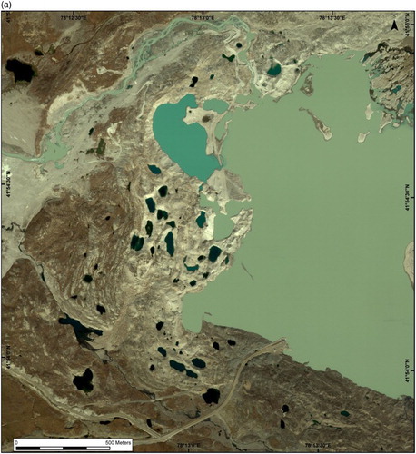
Since the onset of mining at Kumtor, run-off has been directed to the ‘tailings management facility’ ((b)), a reservoir settling pond created by the construction of a dam in the Kumtor Valley. The sediment infill in 2014 was partially exposed due to the lowering of the lake water level. The sands and gravels deposited immediately above the normal water line have formed fan deltas where re-directed glacial meltwater has either entered the lake via canals or spilled from the dam summit canal; these deposits are classified as glaciofluvial outwash even though they have been re-directed to the reservoir.
3.3. Till and associated glacigenic materials
Tills are readily visible over small areas of recently deglaciated mountain valley floors, where they appear fluted ((b)) and hence relate to the passage of temperate basal ice of the polythermal glacier snouts when they extended to their historical, potentially Little Ice Age, maximum positions. On older (pre-Little Ice Age) glaciated surfaces, tills locally thicken to degraded moraines and include small areas of paraglacially modified material and outwash located in minor channels. As the older tills have been modified by periglacial processes their surfaces display patterned ground features, and hence sub-glacial landforms cannot be recognised from aerial imagery.
3.4. Glaciofluvial deposits
Glaciofluvial deposits comprise coarse-grained gravels and sands predominantly organised in valley floor outwash trains or linear sandar. On older glacial deposits, ribbons of glaciofluvial material occur on the floors of inter-moraine channels, particularly well-illustrated on the north side of the Kumtor Valley. Pitted outwash occurs around the margins of Petrov Lake where glaciofluvial deposits have been prograded over stagnant glacier ice. Some small outwash fans did exist at the base of the smaller cirque outlet valleys above the lower Lysii valley ((a) and (b)), but these have been substantially reworked by mining activities (see heavily modified outwash).
3.5. Paraglacial deposits
Paraglacial deposits include those materials recently reworked by cold climate slope processes and conditioned by recent deglaciation. They occur on the steeper slopes of the alpine terrain and include reworked glacigenic material, scree slopes and debris flow fans.
3.6. Residuum and weathered glacigenic materials
Some lower angled slopes and wider mountain summits are draped by residuum or the products of in situ weathering, predominantly frost shattering, of bedrock. Blockfield also occurs on the mountain summits and is characterised by boulder-rich rubble, locally developed into patterned ground. Thin veneers of glacigenic materials are also included in this category as they have often been heavily reworked by periglacial processes.
3.7. Mining spoil dumped on glacier ice
The excavation of the mine has created large volumes of waste material and more recently this contains a significant proportion of glacier ice, as the ablation zone of the Davidov Glacier is being gradually removed from the expanding south quarry face ( and ). The gradual increase in supraglacially dumped spoil has been mapped by CitationJamieson et al. (2015) based upon repeat satellite imagery from 2002 to 2014 and can be seen to initiate reactivation of formerly stagnant ice/hummocky ice-cored terrain and speed-up (surge) activity in the lower Davidov snout and Lysii Cirque Glacier. This is manifest in the 2014 Main Map as crevasses opening up beneath the supraglacial spoil and major compressional bulge fronts in some areas of the thickest spoil (), where the combination of increased overburden and relatively steep slopes have initiated internal creep.
Figure 6. Aerial views of the main mine and its impact on the Davidov Glacier: (a) view in 2003 from Digital Globe's QuickBird platform imagery, when dumped mine rock waste was beginning to impinge on the glacier surface; (b) view extracted from Digital Globe's WorldView-2 platform imagery taken on 5 September 2014, showing the result of excavation of the majority of the Davidov Glacier ablation zone to leave a crevassed icefall from which ice is being quarried.
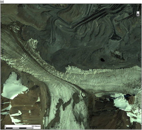
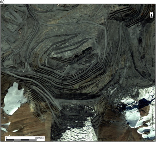
Figure 7. Impacts of mining spoil dumping on the glacier snouts viewed from Digital Globe's WorldView-2 platform imagery taken on 5 September 2014: (a) the lower Davidov Glacier valley, showing mining spoil with compressional bulge fronts (dark grey) and compressional thrust ridge complexes created in permafrost (light grey and brown) by the advance of the ice-cored mining spoil. Note the remains of buildings on the thrust ridges which were gradually bulldozed () by the advancing wave of compressed material; (b) the rapidly advancing, spoil-covered Lysii Cirque Glacier and its surface features of compressional bulge fronts and crevasses (compare with (b) and (c)).
3.8. Made ground
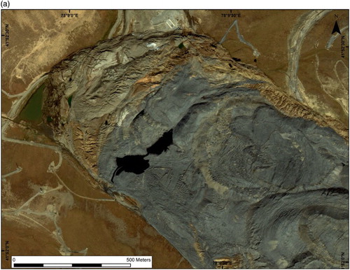
Large areas of the Main Map are characterised by human modification of surface materials into hard standing for buildings, roads, tracks, canals and associated embankments (, , and ). An extensive dam has also been constructed across the broad N–S trending valley in the immediate foothills to the west of the mountain range in order to produce a large settling lake. The most substantial area of made ground is the main mine, which is characterised by multiple terraced bedrock cliffs and access tracks, excavated to a depth of 500 m ( and ). The map also captures the early stages of mine expansion towards the southwest and into the catchment of the Bordoo Glacier ((b)).
Figure 8. Example of made ground and mine infrastructure next to the Davidov Glacier prior to extensive supraglacial spoil dumping and ice excavation (SRK Consulting).
3.9. Heavily and moderately modified outwash
The glaciofluvial outwash that formerly covered the outer foreland of the Petrov Glacier and the neighbouring floor of the Kumtor River Valley ((a) and (b)), where it has not been flooded by the settling lake, has been extensively modified by the removal of aggregate for the local construction of made ground. This is classified as heavily modified where original drainage patterns are difficult or impossible to discern and moderately modified where extraction has not eradicated such patterns.
3.10. Older glacial deposits reactivated by permafrost creep
Some spectacular deformation structures are apparent in three locations where it appears that the permafrozen older glacial deposits have been subject to creep. This is marked by major compressional bulge fronts, where the upslope or up-valley masses of mining spoil and glacier ice have impinged upon the older glacial deposits, causing them to undergo compression and thrust stacking ((a)). Because the formerly stagnant glacier ice has been reactivated by spoil dumping, the construction of compressional forms is effectively a glaciotectonic process, and hence the permafrost creep structures are anthropogenic thrust block or composite moraines, the first examples of such features ever reported.
4. Implications of mapping human-induced landscape change at the Kumtor Mine
The impact of mining activities on cryospheric systems, particularly glaciers, is not new (e.g. CitationBrenning, 2008; CitationEyles & Rogerson, 1977a, Citation1977b; CitationMelvold, Schuler, & Lappegard, 2003) but the ever increasing demand for rare earths to satisfy the consumer demands of an expanding global population has led inevitably to the expansion of mining into cold climate regions and even into extreme glacierised catchments. Even the removal of glaciers in order to access underlying mineral lodes is no longer regarded as economically prohibitive (e.g. CitationBrenning, 2008; CitationCitterio, Mottram, Larsen, & Ahlstrøm, 2010; CitationColgan, 2014; CitationColgan & Arenson, 2013; CitationKronenberg, 2013), and a series of reports on progress with the Kumtor Mine detail exactly how such a monumental task can be undertaken (CitationRedmond et al., 2011; CitationReid et al., 2015; CitationThalenhorst, Redmond, Raponi, & Vdovin, 2012). Given this expansion of high impact mining into glacierised catchments, it is important that glacier science charts and quantifies the response of cryospheric systems and the Main Map presented with this paper signifies the initiation of such monitoring.
The impacts charted here record a number of important, not unrelated, cryospheric responses to mining activity. First, the dumping of mine spoil on receding and thinning glacier snouts has initiated the first ever recorded human-induced glacier speed-up events or surges (CitationJamieson et al., 2015). In addition to this, between 1999 and 2006 the Davidov Glacier had been artificially narrowed by initial spoil dumping, further accelerating its flow rate (CitationJamieson et al., 2015). Second, the expansion of spoil dumping onto down-valley areas of ice-cored moraine and buried glacier ice, survival of which in a continuous permafrost zone constitutes ground ice, has triggered the reactivation (internal creep) of the glacier ice due to increased overburden. Third, the removal of substantial areas of the ablation zones of glaciers will inevitably result in continued, and likely accelerated, ice drawdown from the accumulation zone, resulting in significant incursions of ice into the pit walls and the need for costly mitigation, in the form of either ice excavation or of temporary barrier construction, to allow continued mine operation (CitationReid et al., 2015).
It is also interesting to speculate on what the future holds, especially as repeat imagery will facilitate continued monitoring. Future quarrying will continue to drawdown substantial volumes of glacier ice from the Davidov Glacier catchment and if this ice is not removed artificially (i.e. once the pit becomes disused), the glacier will occupy an artificial bedrock overdeepening (CitationCook & Swift, 2012). Early stages of this will be characterised by ice calving into a deep proglacial lake, the lake water being dammed by the gradually ablating, spoil-covered snout of the lower valley. This would likely constitute a glacial lake outburst flood hazard (cf. CitationJanský et al., 2009; CitationJanský, Šobr, & Engel, 2010), especially as the majority of the pit lies below the equilibrium line altitude and hence would constitute a foreshortened ablation zone/reconstituted glacier (CitationBenn & Lehmkuhl, 2000) fed by ice fall collapse and avalanching.
Software
High-resolution satellite imagery was provided by the DigitalGlobe Foundation. Erdas Imagine was used for processing (i.e. pan-sharpening) of the images. Location maps in the text ( and ) and image excerpts were produced in ESRI ArcGIS. Adobe Illustrator was used to draw the map. Adobe Photoshop was used for glacier image manipulation.
Surficial geology and geomorphology of the Kumtor Gold Mine, Kyrgyzstan: human impacts on mountain glacier landsystems.
Download PDF (41.4 MB)Acknowledgements
We are grateful to the Digital Globe Foundation (www.digitalglobefoundation.org) whose generous donation of high-resolution satellite imagery enabled detailed mapping of the area to be completed. Data compiled for this paper are available upon request from the authors. Thanks for constructive reviews on this paper are due to Richard Waller, Michele Citterio and Chandra Jayasuriya.
Disclosure statement
No potential conflict of interest was reported by the authors.
ORCID
Marek Ewertowski http://orcid.org/0000-0002-0422-2327
Additional information
Funding
Related Research Data
References
- Aizen, V. B., Kuzmichenok, V. A., Surazakov, A. B., & Aizen, E. M. (2006). Glacier changes in the central and northern Tien Shan during the last 140 years based on surface and remote sensing data. Annals of Glaciology, 43, 202–213.
- Avsiuk, G. A. (1953). Lednik Petrova (Petrov glacier). Raboty Tyan’-Shanskoy Fiziko-Geograficheskoy Stantsii 2a. Izdatelsvto Akademii Nauk SSSR, Moscow, 103–131.
- Benn, D. I., & Lehmkuhl, F. (2000). Mass balance and equilibrium line altitudes of glacier in high mountain environments. Quaternary International, 65/66, 15–29.
- Bennett, G. L., & Evans, D. J. A. (2012). Glacier retreat and landform production on an overdeepened glacier foreland: The debris-charged glacial landsystem at Kvíárjökull, Iceland. Earth Surface Processes and Landforms, 37, 1584–1602.
- Bondarev, L. G. (1963). Ocherki po oledeneniyu massiva Ak-Shirak (Studies on the glaciation of the Ak-Schyirak Range). Izdatelstvo Akademii Nauk Kirgizskoi SSR, Frunze.
- Brenning, A. (2008). The impact of mining on rock glaciers and glaciers: Examples from central chile. In B. S. Orlove, E. Wiegandt, & B. Luckman (Eds.), Darkening peaks: Glacier retreat, science and society (pp. 196–205). Berkeley: University of California Press.
- Citterio, M., Mottram, R., Larsen, S. H., & Ahlstrøm, A. (2010). Glaciological investigations at the Malmbjerg mining prospect, central East Greenland. Geological Survey of Denmark and Greenland Bulletin, 17, 73–76.
- Colgan, W. (2014). Considering the ice excavation required to establish and maintain an open ice pit. Journal of Cold Regions Engineering, 28. doi:10.1061/(ASCE)CR.1943-5495.0000067
- Colgan, W., & Arenson, L. (2013). Open-pit glacier ice excavation: Brief review. Journal of Cold Regions Engineering, 27. doi:10.1061/(ASCE)CR.1943-5495.0000057
- Cook, S. J., & Swift, D. A. (2012). Subglacial basins: Their origin and importance in glacial systems and landscapes. Earth Science Reviews, 115, 332–372.
- Davydov, L. K. (1927). Lednik Petrova (Petrov glacier). Trudy Gidromet. Otdel. Sred. Meteorol. Inst., 1(1), 67–100.
- Dolgushin, L. D., & Osipova, G. B. (1982). Pul'siruyushchie ledniki (Surging glaciers). Leningrad: Gidrometeoizdat.
- Dyurgerov, M. B., Liu, C., & Xie, Z. (1995). Oledenenie Tyan’-Shanya (Tien Shan glaciers). Moscow: VINITI.
- Engel, Z., Sobr, M., & Yerokhin, S. A. (2012). Changes of Petrov glacier and its proglacial lake in the Akshiirak massif, central Tien Shan, since 1977. Journal of Glaciology, 58, 388–398.
- Evans, D. J. A. (2009). Controlled moraines: Origins, characteristics and palaeoglaciological implications. Quaternary Science Reviews, 28, 183–208.
- Eyles, N. (1979). Facies of supraglacial sedimentation on Icelandic and Alpine temperate glaciers. Canadian Journal of Earth Science, 16, 1341–1361.
- Eyles, N., & Rogerson, R. J. (1977a). How to save your mine from a glacier. Canadian Mining Journal, 98, 32.
- Eyles, N., & Rogerson, R. J. (1977b). Artificially induced thermokarst in active glacier ice: An example from northwest British Columbia, Canada. Journal of Glaciology, 18, 437–444.
- Jamieson, S. S. R., Ewertowski, M., & Evans, D. J. A. (2015). Rapid advance of two mountain glaciers due to mine-related debris loading. Journal of Geophysical Research – Earth Surface. doi:10.1002/2015JF003504
- Janský, B., Engel, Z., Sobr, M., Benes, V., Spacek, K., & Yerokhin, S. (2009). The evolution of Petrov lake and moraine dam rupture risk (TienShan, Kyrgyzstan). Natural Hazards, 50, 83–96.
- Janský, B., Šobr, M., & Engel, Z. (2010). Outburst flood hazard: Case studies from the Tien-Shan Mountains, Kyrgyzstan. Limnologica – Ecology and Management of Inland Waters, 40, 358–364.
- Kalesnik, S. V., & Epstein, S. V. (1935). Lednikovij uzel Ak-Shyirak (Akshiirk glacier knot). Trudi Lednik. Exped., 2, 321–372.
- Kaulbars, A. V. (1875). Materiali po geographii Tien Shanya sobrannie vo vremya puteshestviya 1869 (Materials on Tien Shan geography, collected within 1869 expedition). Proceedings of the Russian Geographical Society, 5, 253–539.
- Kronenberg, J. (2013). Linking ecological economics and political ecology to study mining, glaciers and global warming. Environmental Policy and Governance, 23, 75–90.
- Kronenberg, J. (2014). Viable alternatives for large-scale unsustainable projects in developing countries: The case of the Kumtor gold mine in Kyrgyzstan. Sustainable Development, 22, 253–264.
- Kuzmichenok, V. A. (1990). Izmenenie lednikov khrebta Akshiirak c 1943 po 1977 godi. (Scale 1: 50,000). Moscow: Main Department of Geodesy and Cartography of the USSR.
- Melvold, K., Schuler, T., & Lappegard, G. (2003). Ground-water intrusions in a mine beneath Höganesbreen, Svalbard: Assessing the possibility of evacuating water subglacially. Annals of Glaciology, 37, 269–274.
- Redmond, D., Thalenhorst, H., & Seto, J. (2011). Technical Report on the Kumtor Gold Project, Kyrgyz Republic, for Centerra Gold Inc. Toronto, Canada.
- Reid, G. D., Wong, J., Raponi, T. R., D'Souza, K., Landry, P., Seto, J., & Chance, A. (2015). Technical Report on the Kumtor Mine, Kyrgyz Republic, for Centerra Gold Inc. Toronto, Canada.
- Sevast'yanov, D. V., & Funtikov, A. B. (1981). Novy dannye ob evollucii vysokogornogo ozera u konca lednika Petrova [New data on the evolution of the mountainous lake in front of the Petrov glacier]. Izv. VGO, 113(5), 430–435.
- Solomina, O., Barry, R. G., & Bodnya, M. (2004). The retreat of Tien Shan glaciers (Kyrgyzstan) since the little ice age. Geografiska Annaler, Series A: Physical Geography, 86(2), 205–215.
- Thalenhorst, H., Redmond, D., Raponi, T. R., & Vdovin, V. (2012). Technical Report on the Kumtor Gold Project, Kyrgyz Republic, for Centerra Gold Inc. Toronto, Canada.