
ABSTRACT
Black truffle (Tuber melanosporum Vittad.) has very specific environmental requirements. We integrated these requirements in a geographic information system and weighted them depending on their importance for the presence of the species, based on previous field and laboratory experience. The parameters considered were divided into three groups: (i) topographic; (ii) climatic and (iii) edaphic. A multicriteria analysis was used to develop a final potential habitat map, and filtering it by land uses we produced the cultivation potential map. The result of this work is a 1:275,000 map of Zaragoza province (Spain) that integrates all mentioned maps. This is a practical tool for territory managers, farmers and researchers who will be capable of identifying the better cultivation zones in the Zaragoza province with this map.
1. Introduction
Black truffle (Tuber melanosporum Vittad.) cultivation is one of the most valuable emerging agroforestry activities throughout the Mediterranean area, however it is not yet completely domesticated. Certain questions regarding its management still remain unsolved, so selecting the area with the highest aptitude possible increases the possibility of success (CitationDe Miguel, Águeda, Sánchez, & Parladé, 2014). Truffle cultivation is a long-term activity, with an expected waiting period of five to seven years before obtaining the first fructifications. However, orchards can remain productive for at least 50 years (CitationHall, Brown, & Zambonelli, 2007). The ecological requirements of this fungus are quite narrow, yet there are many zones with optimal edaphic and climatic conditions to establish cultivation initiatives.
In this work, we analysed the natural factors of black truffle presence in Zaragoza (17,274 km2) province, an area with promising internal cultivation potentiality because of its edaphic and climatic characteristics (CitationPalazón, Delgado, Barriuso, Sánchez, & Asensio, 2008). This region borders the province of Teruel to the south, one of the most productive areas of black truffle in the world with about 4000 ha of plantations (CitationReyna & García-Barreda, 2014). Several authors have published maps of black truffle distribution in Spain (CitationAlonso-Ponce et al., 2010; CitationColinas, Capdevila, Oliach, Fischer, & Bonet, 2007; CitationDomínguez, López, Rodríguez, & Saiz, 2003; CitationHonrubia, Fernández, Moya, González, & de las Heras, 2006; CitationRodríguez, Acedo, Marabel, & Álvarez, 2008), however this map is more accurate, different in its concept and uses a geographic information systems (GIS). Until now a spatial-based methodology has never been developed to determine the capabilities of this area. The final aim is to produce a map of potential cultivation in order to identify the most suitable areas based on environmental requirements of the species.
2. Methods
Cultivation potentiality is based on the potential habitat map of black truffle in the study area. To develop the potential habitat we used a multicriteria analysis (MCA) (CitationBarredo & Bosque, 1998; CitationMalczewski, 1999) applied to black truffle environmental parameters. The complete method is explained in more detail in CitationSerrano-Notivoli, Incausa, Martín, Sánchez, and Barriuso (2015).
The methodology consisted of identifying environmental parameters in a territory based on conditioning and restricting factors of black truffle presence using previous experiences supported by a set of field samples with soil information. MCA is a decision method that works with the weighting of properly selected environmental variables. These variables are geographically defined to show the results depending on their original spatial distribution (CitationMalczewski, 1999). The work process () included the selection of parameters, allocation of weights, GIS integration and land use selection.
Figure 1. Work process of MCA. Adapted from CitationSerrano-Notivoli et al. (2015).
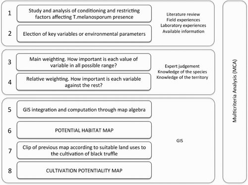
These parameters were clustered in three groups by their nature (CitationColinas et al., 2007; CitationGarcía-Barreda, Reyna, Pérez, Rodríguez-Barreal, & Domínguez, 2012; CitationHall et al., 2007): the first group (i) embraces topographic factors such as altitude (ALT), slope (SLO) and aspect (ASP). The second group (ii) refers to climatic factors. Black truffles grow in semiarid or Mediterranean environments (dry with continental influence) with annual precipitations from 600 to 900 mm (CitationGarcía-Barreda et al., 2012). Most precipitation falls in spring, late summer and autumn (mainly in thunderstorms). Variables included in this group were mean annual precipitation (PTOT), mean summer precipitation (PSUM), mean annual temperature (TMED), mean temperature of the warmest month (TMAX) and mean temperature of the coldest month (TMIN). The third group (iii) is composed of edaphic factors and is the most important because these factors set the conditions of the direct environment where the species have to be developed. Black truffles need very specific soil properties and, as there was no map of the soils of study area, we selected the most important edaphic parameters to be pH which has to be between 7.5 and 8.5, active lime (ALIM) with values under 30%, soil textural class (TEX) understood as the proportion of sand, clay and loam, and organic matter (MAT) (CitationColinas et al., 2007; CitationHall et al., 2007; CitationOlivier, Savignac, & Sourzat, 2012; CitationReyna, 2012).
In the next phase, we integrated all of the information in a GIS to unify formats and spatial distribution. Surface data (ALT, SLO, ASP, PTOT, PSUM, TMED, TMAX and TMIN) was resampled to a 500 m spatial resolution and point data (pH, ALIM, TEX and MAT) were interpolated using ordinary kriging at the same resolution.
Soil data came from 2026 field samples acquired by the Agrifood Research and Technology Centre (CITA) and Agroenvironmental Laboratory of Aragón. Climate data were extracted from the Climatic Atlas of Aragón (CitationLópez, Cabrera, & Cuadrat, 2007), and base maps (boundaries, roads and Digital Elevation Model (DEM)) from the Spanish Geographic Institute (IGN). All parameters used were managed spatially by a GIS, obtaining final values for each point over the entire study area.
We reviewed literature to set the aptitude ranges for each parameter (CitationColinas et al., 2007; CitationIgor, Matteo, & Paolo, 2010; CitationOlivier et al., 2012; CitationReyna, de Miguel, Palazón, Hernández, & de Román, 2003), then assigned different weights (from 0 to 1) to each parameter () depending on its importance for species presence in the territory. The relative weighting was made based on the parameters required by the species and adapted to the area where the potential habitat was computed. We used 12 parameters (, bold) to compute a weighted sum (1) that gave final values of aptitude for the entire area(1) where
is the value for each pixel in the final map computed from the sum of each parameter (
) multiplied by its specific weight (
), divided by the sum of all weights.
Table 1. Explanatory parameters for black truffle presence used to compute potential habitat.
The areas valued at less than 5 were considered not suitable.
Finally we filtered the potential habitat map with several categories of the Forestry Map of Spain 1:50,000 and Corine Land Cover (level 5) land use that are considered the best for black truffle cultivation (). We removed forests, where competing ectomycorrhizal fungi are more common and can compromise truffle production (CitationDe Miguel et al., 2014; CitationReyna, García-Barreda, & Folch, 2006).
Table 2. Categories of the forestry map of Spain 1:50,000 (FMS50) and Corine land cover (CLC50) used to obtain the cultivation potential map and percentage of area represented in the potential habitat map.
3. Results and conclusions
The result of this work is a 1:275,000 map of Zaragoza province (Spain) showing a Main Map containing the cultivation potentiality of black truffle, a secondary map with potential habitats that identifies suitable areas for species development, and three complementary maps showing climatic, edaphic and topographic potential. All of them are divided into four classes defining unsuitable and progressively suitable areas for each variable ().
Figure 2. Percentage of area included in each category of suitability for each map.
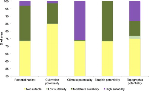
Several parameters in Zaragoza province are restricting because they completely rule out the possibility of species emergence in specific places due to its characteristics (altitude, annual precipitation, mean annual temperature, mean temperature of warmest month and mean temperature of coldest month), and others condition the presence of the species in magnitude and intensity in that place (summer precipitation, slope, etc.). The combination of environmental parameters with zero value (limiting) produces excluded zones coinciding with the low zones of the Ebro Valley, and the warmest and driest areas in general; these zones have the minimum value (not suitable).
Climatic potential is very good in general mainly due to annual and summer precipitation distribution, considered important for black truffle development during its growing cycle (CitationGarcía-Barreda et al., 2012). The edaphic map shows moderate suitability over the entire distribution. Topographic potential is generally good in the whole study area. Low altitudes are common in Zaragoza province, however, those which are well suited to species’ development are best considered due to their combination of altitude and aspect (CitationSerrano-Notivoli et al., 2015).
Potential habitat overall shows good suitability in the southwestern and northern areas. The filtering of this cartography produces a map with fewer zones (42.9% less than potential habitat) covered by suitable areas. However, the best areas are better defined, especially for the northern zone.
Despite the ranges of environmental parameters used, it is very important to have in-depth knowledge of the study area. Therefore, human intervention is required for this method, especially in the weighting of the parameters.
Software
The point data from field samples were managed in a Microsoft Access database, and integrated in an Esri ArcGIS project. With this software, these points were interpolated using geoprocessing tools and the weighting calculation by map algebra. The final layout was also edited with ArcGIS and exported to a PDF to preserve the vector-based format.
Cultivation potentiality of black truffle in the Zaragoza province (Northeast Spain).pdf
Download PDF (10.4 MB)Acknowledgements
The authors would like to thank Ana Incausa and all of the black truffle experts that helped with the evaluation criteria choice and decision. We are thankful to Jeanette Hodgman for improving the English of this manuscript and to Ana de Miguel, Virginie Molinier and Martin von Wyss for their kind and exhaustive revision of this work.
Disclosure statement
No potential conflict of interest was reported by the authors.
Funding
The authors would like to thank the Provincial Council of Zaragoza for the funding.
ORCID
Roberto Serrano-Notivoli http://orcid.org/0000-0001-7663-1202
References
- Alonso-Ponce, R., Águeda, B., Ágreda, T., Modrego, M. P., Aldea, J., & Martínez-Peña, F. (2010). A climatic potentiality model for black truffle (Tuber melanosporum) in Teruel (Spain). Forest Systems, 19(2), 208–220. doi:10.5424/fs/2010192-01315
- Barredo, J. I., & Bosque, J. (1998). Multicriteria evaluation methods for ordinal data in a GIS environment. Geographical Systems, 5, 313–327.
- Colinas, C., Capdevila, J. M., Oliach, D., Fischer, C. R., & Bonet, J. A. (2007). Mapa de aptitud para el cultivo de la trufa negra (Tuber melanosporum Vitt.) en Cataluña. Solsona: Centro Tecnológico Forestal de Cataluña.
- De Miguel, A. M., Águeda, B., Sánchez, S., & Parladé, J. (2014). Ectomycorrhizal fungus diversity and community structure with natural and cultivated truffle hosts: Applying lessons learned to future truffle culture. Mycorrhiza, 24(Suppl. 1), S5–S18. doi:10.1007/s00572-013-0554-3
- Domínguez, J. A., López, C., Rodríguez, J. A., & Saiz, J. A. (2003). Caracterización de rodales truferos en la Comunidad Valenciana. Ecología, 17, 181–190.
- García-Barreda, S., Reyna, S., Pérez, R., Rodríguez-Barreal, J. A., & Domínguez, J. A. (2012). Ecología de la trufa y las áreas truferas. In S. Reyna (Ed.), Truficultura. Fundamentos y técnicas (pp. 151–206). Madrid: Mundiprensa.
- Hall, I. R., Brown, G. T., & Zambonelli, A. (2007). Taming the truffle. The history, lore, and science of the ultimate mushroom. Portland, OR: Timber Press.
- Honrubia, M., Fernández, A., Moya, D., González, A., & de las Heras, J. (2006). Potencialidad de la trufa negra (Tuber nigrum Bull.) en la provincia de Albacete. Montes, 83, 35–40.
- Igor, B., Matteo, G., & Paolo, R. (2010). Carte di attitudine dei suoli ai tartufi in Piemonte metodologie e risultati. Paper presented at 3° Congresso Internazionale di Spoleto sul Tartufo, Spoleto.
- López, F., Cabrera, M., & Cuadrat, J. M. (2007). Atlas Climático de Aragón. Zaragoza: Environment Department, Aragon Government.
- Malczewski, J. (1999). GIS and multicriteria decision analysis. New York: John Wiley.
- Olivier, J. M., Savignac, J. C., & Sourzat, P. (2012). Truffe et Trufficulture. Périgueux: Editions Fanlac.
- Palazón, C., Delgado, I., Barriuso, J., Sánchez, S., & Asensio, C. (2008). Obtención de trufa negra (Tuber melanosporum Vitt.) a partir de plantación cultivada, en terreno tradicional de regadío. Información Técnica Económica Agraria, 104(4), 472–481.
- Reyna, S. (2012). Truficultura. Fundamentos y técnicas. Madrid: Mundi-Prensa.
- Reyna, S., & García-Barreda, S. (2014). Black truffle cultivation: A global reality. Forest Systems, 23, 317–328. doi:10.5424/fs/2014232-04771
- Reyna, S., García-Barreda, S., Folch, L. (2006). Influencia del uso del suelo sobre el potencial de inóculo ectomicorrícico y la competitividad de las ectomicorrizas de Tuber melanosporum: evaluación mediante bioensayos en invernadero. Investigación Agraria: Sistemas Recursos Forestales, 15(3), 308–320.
- Reyna, S., de Miguel, A., Palazón, C., Hernández, A. & de Román, M. (2003). Truffle cultivation in Spain: State of the art and future prospects. Paper presented at 3rd International Workshop on Edible and Mycorrhizal Mushrooms, University of Victoria, British Columbia, Canada.
- Rodríguez, J. R., Acedo, C., Marabel, M., & Álvarez, M. F. (2008). Localización mediante SIG de zonas potencialmente truferas en la provincia de León. Espacio, Tiempo y Forma. Serie VI, Geografía, 1, 83–91.
- Serrano-Notivoli, R., Incausa, A., Martín, M., Sánchez, S., & Barriuso, J. J. (2015). Modelización espacial del hábitat potencial de la trufa negra (Tuber melanosporum Vittad.) en la provincia de Huesca (España). Información Técnica Económica Agraria. doi:10.12706/itea.2015.015