
ABSTRACT
Few detailed geomorphological maps of the Central Andes are available despite the wide diversity of landforms. We present a 1:20,000 geomorphological map of the Ampato volcanic complex resulting from the interpretation of vertical aerial photographs (1955), MrSID resolution satellite image and oblique aerial photographs (1943). To classify the relief, Simonov [(1972). Regional geomorphological analysis [in Russian]. Moscow: Mosk. Gos. Univ] criteria are combined with the International Institute for Aerospace Survey and Earth Sciences (ITC) method. The use of both techniques allows us to represent 35 landform types distributed over an area of 930 km2 and to identify the geomorphic processes involved in their morphogenesis.
1. Introduction
Geomorphological mapping is a traditional technique frequently used to represent relief (CitationPeña Monné, Pellicer Corellano, Chueca Cía, & Julián Andrés, 1997). Its development is important because it enables us to show: (a) the type and distribution of landforms created by constructive and destructive processes; (b) their conservation status; (c) a relative chronology allowing reconstruction of the landscape evolution; (d) the most geomorphologically active and hazardous areas.
However in some regions, such as the Central Andes, the application of detailed geomorphological mapping is limited despite the great diversity of the relief. Most previous work in the Central Andes focused on glacial landform schemes to date glacier advances or deglaciation (CitationBromley et al., 2009, Citation2011; CitationGlasser, Clemmens, Schnabel, Fenton, & Mchargue, 2009; CitationHall et al., 2009; CitationKelly et al., 2012; CitationMay et al., 2011; CitationSmith, Lowell, & Caffee, 2009), geology (CitationThouret et al., 2001, Citation2005) and hazards (CitationCobeñas, Thouret, Bonadonna, & Boivin, 2012; CitationSandri, Thouret, Constantinescu, Blass, & Tonini, 2014). Nevado Coropuna presents the most complete glacial and periglacial mapping of the Central Andes (CitationForget, Thouret, Kuentz, & Fontugne, 2008; CitationÚbeda, 2013), but its volcanic landforms have not been represented accurately enough.
The aim of this study is to provide a precise geomorphological map of the Ampato volcanic complex Main Map (15°24′–15°51′S/71°51′–73°W; 6288 masl). This complex was selected because it is formed by three stratovolcanoes of different ages and thus displays a wide diversity of volcanic and exogenous landforms due to an unusual arid climate since ∼ 15 Ma allowing their preservation (CitationKarátson, Telbisz, & Wörner, 2012). The information obtained will contribute to a wider understanding of volcanic evolution, dating glacial landforms to reconstruct their paleoclimatic implications and increase current knowledge of the interaction between volcanic activity and glaciers.
The map also provides significant support for the analysis of potential hazard and associated risks. To the north the Ampato volcanic complex borders the Colca canyon, one of the deepest on earth. This valley has a population of over 25,000 inhabitants, mainly concentrated in the towns of Chivay, Achoma, Cabanaconde and Caylloma with important agricultural and tourism activities.
2. Geographical setting
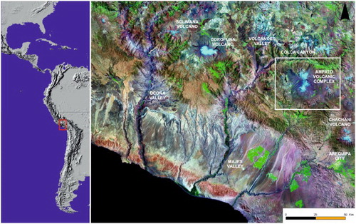
The Ampato volcanic complex, 70 km northwest of Arequipa city, is one of the highest peaks of the Central Andean Volcanic Zone (). This volcanic arc present 44 active volcanoes and at least 6 caldera system (CitationIsacks, 1988; CitationStern, 2004). The vulcanism is associated to the subduction of the Nazca Plate beneath the South America Plate, a process originated in the Jurassic due to opening and expansion of the South Atlantic Ocean, with a dip ∼ 30° (CitationRamos, 1999). A stepper dip between the Nazca Plate and South America Plate has been related with the presence of aseismic ridges in the subduction dynamic (CitationStern, 2004).
Figure 1. Location of the Ampato volcanic complex within the Andean range.
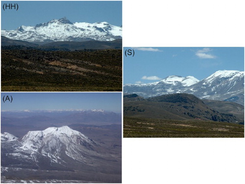
The Ampato complex extends over 630 km2 and rises 2000 m above the surrounding Altiplano (4000 masl) except to the north where it adjoins the Colca Canyon. Here fluvial incision in volcanic deposits (ignimbrites and lavas) has produced relief of 3500 m. The mountain is formed by three large andesitic stratovolcanoes aligned N–S: HualcaHualca (6025 masl); Sabancaya (5980 masl) and Ampato (6288 masl) ().
Figure 2. West faces of: (HH) HualcaHualca (A) Ampato and (S) Sabancaya volcanoes.
The construction of these edifices began during the Late Miocene or Lower Pleistocene, due to a drastic change in the subduction dip between the Nazca and South America plates (CitationStern, 2004), and was established on Mesozoic and Cenozoic sedimentary materials. The most recent layers correspond to the Sencca formation that is formed by two distinct ignimbrites sheets of 4.9–3.6 and 2.3–1.4 Ma (CitationThouret et al., 2007).
HualcaHualca is considered an extinct volcano (CitationThouret et al., 2005). This edifice is characterized by a horseshoe-shaped caldera resulting from the collapse of the northern flank. The existence of slopes affected by abrasion and over-deepening, well-preserved sequences of moraines, roches moutonnées and rock glaciers indicates high levels of past glacial and periglacial activity.
Ampato is classified as a dormant volcano (CitationThouret et al., 2005) and presents a fresh volcanic morphology only slightly modelled by glaciers. However, Sabancaya is the youngest volcanic structure of the Ampato volcanic complex. Its summit is formed by two coalescent cones which emitted thick, fresh, blocky Holocene lava flows. Several historical eruptive events have also been recorded on Sabancaya. The Spanish chronicles refer to an eruptive period between 1750 and 1784 (CitationGerbe & Thouret, 2004) and other Vulcanian or phreatomagmatic events have frequently occurred since 1986 (CitationThouret et al., 2002).
3. Methods
A geomorphological map (scale 1:20,000) of the Ampato volcanic complex was produced from detailed analysis of vertical aerial photographs (scale 1:35,000, Instituto Geográfico Nacional de Peru, 1955), an 2000 orthorectified MrSID high resolution satellite imagery (Landsat Geocover ETM+; 3 bands: red, green and blue; Cell size: 14.25 × 14.25; Spatial reference: WGS_84_UTM_Zone_18N; Datum: D_WGS_1984; Latitude of origin: 0) and 16 oblique aerial photographs (Servicio Aerofotográfico Nacional de Peru, 1943).
The first step to delimit landforms identified in the photointerpretation and the MrSID satellite image analysis was to determine an appropriate scale. The Instituto Geográfico Nacional de Peru provided 1:100,000 topographic maps but this scale was considered insufficient and was therefore transformed, increasing the map scale to 1:20,000.
To represent the landforms in detail the standard procedures proposed by CitationBashenina (1977), CitationSimonov (1972) and the International Institute for Aerospace Survey and Earth Sciences (ITC) systems (CitationVerstappen & Van Zuidam, 1991) were combined and adapted to the characteristics of the study area. These mapping methods classify the relief based on a morphogenetical and morphochronological criteria that include data of lithology as well as morphostructures using several colours and areal, lineal and point symbols. Moreover, these methods enabled the spatial configuration of landforms to be shown as well as the relationship between the morphological characteristics, the type of rock and their structural arrangement.
Thus, the relief was divided into two major types: volcanic and exogenous. Volcanic relief was grouped into the following categories: structural, denudative and modelled. The term exogenous was selected from CitationSimonov (1972) as it clearly includes all the landforms derived from weathering, erosion and detritus accumulation.
The colour coding used is as follows: red represents structural volcanic relief; orange represents landforms related to volcanic collapse; brown colour range differentiates denudative landforms; violet, green and pink classify exogenous relief. Different symbols are also used to show the attributes of each landform type. The relative age of neighbouring landforms is shown by arrows indicating their relative position.
The map was verified with fieldwork, except for the inaccessible summits and their surrounding areas. Then the map was digitized using ArcMap 9.3 software, with its characteristic high capacity for geo-referencing, digitizing and spatial or statistical analysis. Finally, the map was exported to CorelDraw 13 software for final editing. Therefore, the geomorphic map of the Ampato volcanic complex clearly shows the following information: (a) Landforms produced by volcanic activity; (b) Definition and delimitation of each landform; (c) Relief shaped by exogenous processes and the spatial relationships between ‘structural volcanic landforms' and ‘modelled' features; (d) Relative chronological order of the volcanic, glacial and periglacial stages.
4. Landform inventory and description
The geomorphological map of the Ampato volcanic complex represents 17 volcanic reliefs and 18 varieties of exogenous reliefs. In total, 35 types of landforms are mapped, distributed over an area of 930 km2.
The volcanic relief is divided into three subcategories: structural volcanic relief, landforms associated with volcanic collapse and denudative volcanic relief. The exogenous relief is classified in five units: glacial, periglacial, fluvial, lacustrine and slope landforms.
4.1. Volcanic relief
The landforms integrating the volcanic relief of the Ampato volcanic complex are directly related to eruptive activity. The landforms mapped include compound volcanoes, lava cones, cinder cones, lava domes, craters, vents and several generations of lava flows.
4.1.1. Structural volcanic relief
The structural volcanic relief includes volcanic landforms with no signs of erosion and therefore all of them display the original configuration. Most of the structural volcanic reliefs are associated with the Ampato and Sabancaya volcanoes. Lava flows and domes are the most common geomorphologies with some notably filling valleys excavated by glaciers during the last glaciation.
Ninety-two per cent of the lava flows mapped in the Ampato volcanic complex are covered by a pyroclastic layer. Its origin has been attributed to Vulcanian and Plinian eruptions emitted by Ampato and Sabancaya stratovolcanoes ((a)). The pyroclastic cover is thicker on the southern lava flows, suggesting a predominantly N or E wind during the volcanic events. The rest of the lava flows, associated with Sabancaya volcano, display fresh morphology. All of them present original structures such as pressure ridges on their surfaces and do not show effects of Holocene cold episodes.
Figure 3. (a) Fresh lava flows located in the west slopes of Ampato and Sabancaya volcanoes. Some of them are channelled through glacial valleys generated during the maximum glacier expansion. (b) Detail of the vents situated on the southwest flank of HualcaHualca volcano close to active glacial cirques (Google earth image, 2012).
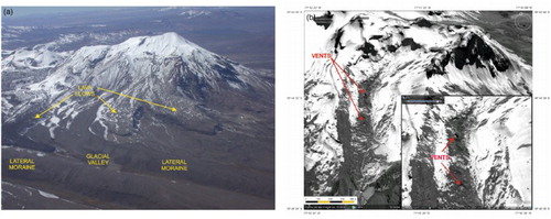
Another contribution of this study is the identification of seven vents on the southwestern flank of HualcaHualca, closer to the summit and aligned NW–SE, which present a fresh morphology. Each vent emitted short, thin lava flows that preserve the original surface morphologies. This is consistent evidence indicating Holocene volcanic activity on HualcaHualca, a volcano classified as extinct ((b)).
4.1.2. Landforms associated with volcanic collapse
The northern flank of HualcaHualca volcano was affected by a volcanic collapse (). The triggering mechanism has been linked to a combination of hydrothermal and seismic activity, evidenced by the intense weathering of the edifice and the existence of the Huambo-Cabanaconde fault system located in the northern sector of the study area. Furthermore, juvenile materials are absent in the debris avalanche deposits (CitationOcola & Gómez, 2005).
Figure 4. Landforms and tectonic elements related to the volcanic collapse occurred on the northern flank of HualcaHualca volcano: (a) Volcanic collapse slopes; (b) Huambo and Cabanaconde fault system and (c) Lacustrine deposits (Google earth image, 2012).
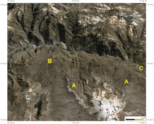
The debris avalanche travelled 14 km to the north, filling the Colca valley and forming a paleolake. As a result, there are deep lacustrine deposits upstream from the towns of Pinchollo and Lari. Morphologically, this destructive process created a horseshoe-shaped crater running E–W. Two debris avalanche scarps separated by a depression of 186 km2 were identified. The western and eastern scarps are 15.5 and 7.5 km long, respectively. The non-continuity between these two scarps is related to intense glacial activity.
Two rock walls were delimited with 35°–65° slope, also displaying non-continuity due to the presence of glacial cirques at their upper limits. The NW rock wall presents 1000 m of maximum relief and extends over 15.7 km2. The NE rock wall is smaller with 700 m of maximum relief and an area of 7 km2. The contact between both rock walls and the bottom of the caldera is smooth as a result of the formation of debris sheets and rock falls produced by periglacial processes or stationary fluvial sedimentation.
The avalanche debris deposits associated to this event were identified 12 km from the crater. These deposits present a hummocky topography or form avalanche deposit sheets. Both deposits may have covered a greater area in the past because the volcano failure affected an area of 186 km2. In this case most of the deposits may have been eroded by the fluvial system or buried under several metres of lava flows and pyroclastic deposits linked to post-avalanche volcanic eruptions.
4.1.3. Denudative volcanic relief
This category includes volcanic landforms that have been partly shaped by exogenous processes. Glaciers were the major erosive agent in the study area especially during the last glacial extent when the ice masses advanced to their lowest altitudes.
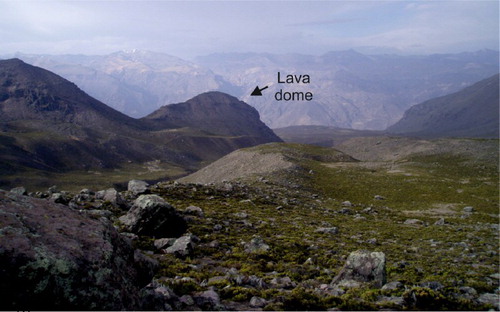
Volcanic domes (), scoria cones, lava cones and lava flows are the major landforms transformed by glacial or fluvial erosion. These relief forms present one or more slopes with polished and striated surfaces indicating intense glacial erosion, or appear partially destroyed.
Figure 5. Lava dome partially eroded by glaciers in the Huayuray valley (north side of HualcaHualca volcano).
4.2. Exogenous relief
The exogenous relief of the study area encompasses a wide range of eroded and accumulative landforms, resulting from the dismantling and destruction of the structural volcanic relief produced by the dynamic action of external processes.
External processes are chemical or physical changes capable of modifying the original configuration of the Earth´s surface. Four types of external processes act permanently on the volcanic relief of the study area: weathering (physical and chemical), erosion, denudation and sedimentation.
Mechanical rock fragmentation in the study area is produced by intense daily temperature fluctuations while chemical alteration is related to the hydrothermal influence, particularly intense on HualcaHualca volcano where a thick weathered mantle has been generated on volcanic rocks. Erosion, denudation and sedimentation are carried out fundamentally by glaciers, fluvial system, temperature oscillations and mass movements.
4.2.1. Glacial landforms
The effects of morphogenetic glacial action are evident in the Ampato volcanic complex. Previous weathering (hydrothermalism) and frequent climatic fluctuations in the central Andes such as the Last Glacial Maximum or Late Pleistocene cold events, with significant thermal decrease and substantial precipitation increase affecting the Equilibrium Line Altitude, created a long-term environment conducive to optimal glacier development.
The intensity of the glaciation is reflected especially on the northern and southwestern flanks of HualcaHualca volcano where weathering or steeper slopes, associated with edifice failure, amplified the magnitude of glacier erosion. This local topography led to the increased abrasive and over-deepening capacity of the ice masses, forming numerous moraines which have been preserved due to the absence of relevant eruptive episodes, at least since the last glacier extent, and to the arid conditions which minimized the erosion rate.
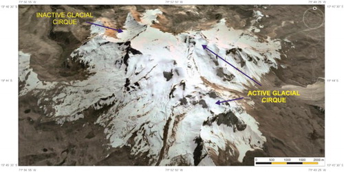
Ninety-one glacial cirques were identified, with 71 classified as inactive and 20 as active. The inactive cirques are distributed throughout the whole complex above ∼ 3200 masl while the active cirques are located above ∼ 5500 masl (). The SW and S facing slopes are the most appropriate for glacier cirque formation in the Ampato volcanic complex. However, the glaciers have almost disappeared on the Sabancaya volcano as a consequence of historical volcanic eruptions. Only a small ice mass has been detected on the E flank of the volcano close to the crater covered by a thick pyroclastic mantle.
Figure 6. Active and inactive glacial cirques from the south to the north flanks of HualcaHualca volcano (Google earth image, 2012).
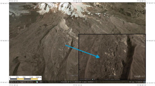
Four types of morainic landforms were also identified in the study area: inner moraines (), lateral moraines, frontal moraines and morainic crests. Inner moraines are massive debris accumulations, deposited during glacier retreat, which adopt both an irregular or regular hummocky landscape that partially fills the glacial valleys on HualcaHualca. The genesis of the material is linked to the higher debris production on scarps and the walls of glacial cirques as a result of intense gelifraction.
Figure 7. Inner moraine situated in the eastern flank of HualcaHualca volcano, where partially fill the glacial valley (Google earth image, 2012).
Lateral and frontal moraines are widely distributed throughout the Ampato volcanic complex. The most voluminous deposits are located on HualcaHualca volcano while smaller morainic ridges are recorded on Ampato and Sabancaya because the conical shape of these volcanoes controlled glacier size. Based on geomorphological analysis and their altitudinal distribution, at least four morainic generations can be established:
(a) Lateral and frontal moraines related to glacier expansions prior to the last maximum extent.
A frontal moraine was identified at ∼ 4650 masl on the NE flank of HualcaHualca volcano. This moraine presents a degraded morphology and rests on an old lava flow that has not been affected by volcanic collapse. Upslope there is no evidence of glacial catchments thus its likely origin is a former glacier advance.
(b) Lateral and frontal moraines associated with maximum glacier extent (MGE).
This generation is formed by well-preserved, voluminous moraine ridges distributed throughout the whole volcanic complex especially on HualcaHualca volcano ((a)). The lowest ridge is situated on the N slope of HualcaHualca volcano at ∼ 3650 masl. No evidence of glaciation has been detected beyond this outermost moraine. According to a preliminary 36Cl exposure surface dating on moraine boulders in Huayuray valley (northern slope on HualcaHualca volcano), the MGE occurred ∼ 18–16 ka a chronology in agreement with the Heinrich 1 stadial and Tauca paleolake cycle of the Altiplano (CitationAlcalá, Palacios, Vázquez, & Zamorano, 2015).
(c) Lateral and frontal moraines related to re-advances or recessional glacier phases.
Figure 8. (a) Moraines of the MGE in the eastern flank of HualcaHualca volcano. (b) Moraines of the MGE and readvance phases (RA) in the Huayuray valley (northern side of HualcaHualca volcano).
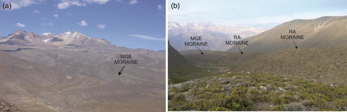
Dozens of lateral and frontal moraines are distributed between ∼ 4100 and 5500 masl ((b)). These deposits consist of a single ridge or form ridge complexes with no signs of erosion. The height of some moraines, around to ∼ 100 m, indicates important increments in ice thickness due to a positive mass balance, probably caused by increased precipitation in catchments during these phases. Moreover, 36Cl exposure surface dating on a moraine boulder associated with the last significant readvance on the northern side of HualcaHualca volcano shows an age of ∼ 12 ka, presumably in synchrony with the Younger Dryas cold event and the Coipasa paleolake cycle of the Altiplano (CitationAlcalá et al., 2015).
(d) Lateral and frontal moraines close to modern glacier fronts.
Several moraines have been mapped above ∼ 5300 masl, close to modern glacier fronts. All of them are well preserved and up to 10 m high. According to their position, the origin of these deposits is attributed to historical glacier expansions such as the Little Ice Age.
4.2.2. Periglacial landforms
This category includes all landforms associated with freeze/thaw cycles on ground and rocks. The most numerous periglacial landforms identified in the study area are rock glaciers which indicate freeze/thaw distribution. 65 rock glaciers were mapped above ∼ 4600 masl, 60% located on southern and southeastern slopes and 40% on northwest and western slopes.
Using geographical criteria, most of the Ampato volcanic complex lobes are talus rock glacier type. Their formation occurs in glacial cirques or on scarps with active gelifraction and lava flow fronts. The rest are glacial debris derived rock glaciers whose genesis is related to moraines with inner discontinuous permafrost.
The maximum mean altitude of rock glacier formations is located at ∼ 5000 masl while the minimum mean terminus altitude is ∼ 4875 masl. The highest position of rock glaciers is at ∼ 5500 masl and the lowest at ∼ 4600 masl. Therefore, analysis of their distribution indicates that potential discontinuous permafrost in the Ampato volcanic complex is located between ∼ 4600 and 5500 masl.
Based on the presence of flow morphologies on rock glacier surfaces and the existence of a steeper front topography through aerial photograph interpretation, two generations of rock glaciers were differentiated: inactive or relict lobes, without flow morphologies and collapse structures, located at ∼ 4600–5000 masl; and active rock lobes with surface morphology showing a clear alternation of ridges and furrows distributed ∼ 5000–5500 masl.
4.2.3. Fluvial landforms
Fluvial processes occur mainly in the northern part of the study area. Here a c. 35 km long sector of the Colca valley was mapped. The high slope and intense tectonic uplift that generated several fractures or fault systems were factors facilitating fluvial incision. As a result a deep canyon has been excavated with scarped walls on sequences of ignimbrites and lava flows.
Topographic measurements indicate that the deepest point of the Colca canyon in the mapped area reaches 2.5 km. Climate also played a relevant role in the Colca valley formation. Although the current climate is arid, wet phases (Tauca and Coipasa) are recorded during the Late Pleistocene which may have increased the water supply to the Colca basin and accentuated fluvial incision.
4.2.4. Lacustrine landforms
Northeast of the Ampato volcanic complex, lacustrine deposits were identified associated with a paleolake generated by the HualcaHualca debris avalanche. The lacustrine deposits present a steep morphology due to a complex combination of gravitational processes (landslides) and different fluvial incision phases related to tectonic uplift.
4.2.5. Gravitational landforms
Gravitational landforms include erosive and accumulative relief in the study area created by the influence of gravity. One scarp rockfall was detected on the left wall of Colca canyon and nine cirque landslides on both walls. The largest cirque landslide, 2650 m wide and 815 m long, originated on an extensive lava flow.
Debris cones, rockfall talus slopes and debris sheets are mainly distributed in the HualcaHualca volcano caldera, at the foot of the two slopes generated by volcanic collapse. These were formed by significant debris produced by gelifraction probably as a consequence of the high level of disjunctive lines present in the rock.
5. Conclusions
The 1:20,000 geomorphological map obtained of the Ampato volcanic complex clearly shows the distribution and characteristics of volcanic and exogenous landforms. This map provides a consistent base for ongoing research related to volcanic or glacial evolution hypotheses, glacial-volcanic interaction and their dynamics or geomorphic hazards. The mapping also allowed us to confirm initial observations, based on the difference in age of these volcanoes, suggesting that the Ampato volcanic complex presents a wide variety of landforms. Therefore, this complex constitutes a key area for geomorphological studies because it contains most of the volcanic processes, materials and landforms that could be generated in other sites of the Central Andes. Moreover, the Ampato complex present a well-preserved moraine record, already preliminary dated by 36Cl cosmogenic isotope, suitable to relate the past glacier response with the cold and wet climatic episodes since the global Last Glacial Maximum.
Software
Esri ArcMap 9.3 software was used for geo-referencing, digitizing, visualizing orthorectified aerial photographs or remote sensing images and spatial or statistical analysis. CorelDraw 13 software was used for final editing. The map was exported from CorelDraw 13 to.pdf format.
Geomorphological Map of the Ampato Volcanic Complex (Southern Peru).pdf
Download PDF (15.6 MB)Disclosure statement
No potential conflict of interest was reported by the authors.
Funding
This work was supported by the Spanish Ministry of Economy and Competitiveness in Project [CGL2012-35858].
References
- Alcalá, J., Palacios, D., Vázquez, L., & Zamorano, J. J. (2015). Timing of maximum glacial extent and deglaciation from HualcaHualca volcano (southern Peru), obtained with cosmogenic 36Cl. Geophysical Research Abstracts, 17. EGU2015-12930-1, 2015.
- Bashenina, B. (1977). Geomorphological mapping. High level education. Moscu: URSS. (In Russian).
- Bromley G. R.M., Schaefer J. M., Winckler, G., Hall, B. L., Todd, C. E., & Rademaker, c K. M. (2009). Relative timing of last glacial maximum and late-glacial events in the central tropical Andes. Quaternary Science Reviews, 28(23–24), 1–13. doi: 10.1016/j.quascirev.2009.05.012
- Bromley, R. M., Hall, B. L., Schaefer, J. M., Winckeler, G., Todd, C. E., & Rademaker, K. M. (2011). Glacier fluctuations in the southern Peruvian Andes during the late-glacial period, constrained with cosmogenic 3He. Journal of Quaternary Science, 26(1), 37–43. doi: 10.1002/jqs.1424
- Cobeñas, G., Thouret, J. C., Bonadonna, C., & Boivin, P. (2012). The c.2030yr BP Plinian eruption of El Misti volcano, Peru: Eruption dynamics and hazard implications. Journal of Volcanology and Geothermal Research, 241–242, 105–120. doi: 10.1016/j.jvolgeores.2012.06.006
- Forget, M., Thouret, J. C., Kuentz, A., & Fontugne, M. (2008). Héritages glaciaires, périglaciaires et évolution récente: le cas du Nevado Coropuna (Andes centrales, sud du Pérou). Géomorphologie: Relief, Processus, Environnement, 2, 113–132. doi: 10.4000/geomorphologie.6383
- Gerbe, M. C., & Thouret, J. C. (2004). Role of magma mixing in the petrogenesis of tephra erupted during the 1990–98 explosive activity of Nevado Sabancaya, southern Peru. Bulletin of Volcanology, 66, 541–561. doi: 10.1007/s00445-004-0340-3
- Glasser, N. F., Clemmens, S., Schnabel, C., Fenton, C. R., & Mchargue, L. (2009). Tropical glacier fluctuations in the Cordillera Blanca, Peru between 12.5 and 7.6 ka from cosmogenic 10Be dating. Quaternary Science Reviews, 28, 3448–3458. doi: 10.1016/j.quascirev.2009.10.006
- Hall, S. R, Farber, D. L., Ramage, J. M., Rodbell, D. T., Smith, J. A., Mark, B. G., & Kassel, C. (2009). Geochronology of quaternary glaciations from the tropical Cordillera Huayhuash, Peru. Quaternary Science Reviews, 28, 2991–3009. doi: 10.1016/j.quascirev.2009.08.004
- Isacks, B. (1988). Uplift of the central Andes plateau and bending of the Bolivian Orocline. Journal of Geophysical Research, 93, 3211–3231. doi: 10.1029/JB093iB04p03211
- Karátson, D., Telbisz, T., & Wörner, G. (2012). Erosion rates and erosion patterns of Neogene to quaternary stratovolcanoes in the Western Cordillera of the Central Andes: An SRTM DEM based analysis. Geomorphology, 139–140, 122–135. doi: 10.1016/j.geomorph.2011.10.010
- Kelly, M. A., Lowell, T. V., Applegate, P. J., Smith, C. A., Phillips, F. M., & Hudson, A. M. (2012). Late glacial fluctuations of Quelccaya Ice Cap, southeastern Peru. Geology, 40, 991–994. doi: 10.1130/G33430.1
- May, J. H., Zech, J., Zech, R., Preusser, F., Argollo, J., Kubik, P. W., & Veit, H. 2011. Reconstruction of a complex late quaternary glacial landscape in the Cordillera de Cochabamba (Bolivia) based on a morphostratigraphic and multiple dating approach. Quaternary Research, 76, 106–118. doi: 10.1016/j.yqres.2011.05.003
- Ocola, L., & Gómez, J. C. (2005). Peligro geológico potencial del valle del Colca, sector medio: metodología y aplicación (Informe interno). Instituto Geofísico de Perú (IGP), 101p.
- Peña Monné, J. L., Pellicer Corellano, F., Chueca Cía, J., & Julián Andrés, A. (1997). Leyendas para mapas geomorfológicos a escalas 1:100.000/1:200.000 y 1:25.000/1:50.000. En J. L. Peña Monné (Ed.), Cartografía Geomorfológica Básica y Aplicada (pp. 127–143). Logroño: Geoforma Ediciones.
- Ramos, V. A. 1999. Plate tectonic setting of the Andean cordillera. Episodes, 22(3), 183–190.
- Sandri, L., Thouret, J. C., Constantinescu, R., Blass, S., & Tonini, R. (2014). Long-term multi-hazard assessment for El Misti volcano (Peru). Bulletin of Volcanology, 76, 771. doi:10.1007/s00445-013-0771-9
- Simonov, Yu G. (1972). Regional geomorphological analysis. Moscow: Mosk. Gos. Univ. [In Russian].
- Smith, C. A., Lowell, T. V., & Caffee, M. W. (2009). Late glacial and holocene cosmogenic surface exposure age glacial chronology and geomorphological evidence for the presence of cold-based glaciers at Nevado Sajama, Bolivia. Journal of Quaternary Science, 24, 360–372. doi: 10.1002/jqs.1239
- Stern, C. R. (2004). Active Andean volcanism: its geologic and tectonic setting. Revista Geológica de Chile, 2, 161–206.
- Thouret, J.-C., Finizola, A., Fornari, M., Suni, J., Legeley-Padovani, A., & Frechen, M. (2001). Geology of El Misti volcano nearby the city of Arequipa, Peru. Geological Society of American Bulletin, 113, 1593–1610. doi: 10.1130/0016-7606(2001)113<1593:GOEMVN>2.0.CO;2
- Thouret, J. C., Juvigne, E., Mariño, J., Moscol, M., Loutsch, L., Davila, J., … Rivera, M. 2002. Late pleistocene and holocene tephro stratigraphy and chronology in southern Peru. Boletín de la Sociedad Geológica del Peru, 93, 45–61.
- Thouret, J. C., Rivera, M., Wörner, G., Gerbe, M. C., Finizola, A., Fornari, M., & Gonzales, y. (2005). Ubinas: the evolution of the historically most active volcano in southern Peru. Bulletin of Volcanology, 67, 557–589. doi: 10.1007/s00445-004-0396-0
- Thouret, J. C., Wörner, G., Gunnell, Y., Singer, B., Zhang, X., & Souriot, T. (2007). Geochronologic and stratigraphic constraints on canyon incision and Miocene uplift of the Central Andes in Peru. Earth and Planetary Science Letters, 263, 151–166. doi: 10.1016/j.epsl.2007.07.023
- Úbeda, J. (2013). Cronologías glaciales del sector NE del Nevado Coropuna (Perú): Implicaciones geomorfológicas y paleoclimáticas. Boletín de la Asociación de Geógrafos Españoles, 62, 213–236.
- Verstappen, H. T., & Van Zuidam, R. A. (1991). The ITC system of geomorphological survey. ITC Publication. 10, 89 pp.
- Verstappen, H. T., Zuidam, R. A. van., Meijerink, A. M. J., & Nossin, J. J. (1991). The ITC system of geomorphologic survey: A basis for the evaluation of natural resources and hazards, ITC publication (no. 10). Enschede: ITC, 89 p.