
ABSTRACT
We present the results of helicopter- and field-based geological mapping of Elu Inlet and Melville Sound, Kitikmeot Region of Nunavut, Arctic Canada. The area includes a ∼150 km-wide belt of Proterozoic sedimentary rocks that unconformably overlie the Archean Slave Province of the Canadian Shield and are cross-cut by Neoproterozoic mafic rocks and covered by early Palaeozoic deposits. This work introduces an updated sedimentologic, stratigraphic, and structural framework for the area and is corroborated by geophysical analysis of natural radioactivity. Three Proterozoic sedimentary sequences have been identified, spanning in age from ∼1.9 to ∼1.2 Ga, and including fluvial–aeolian sandstone and shallow-marine carbonate rocks. Mass-spectrometric analyses identified above-baseline concentrations of uranium along the unconformities underlying the two oldest Proterozoic sequences. Proterozoic deposits display weak deformation, related to syn-orogenic foreland and intracratonic-sag stages of the Kilohigok and Elu basins, respectively.
1. Introduction
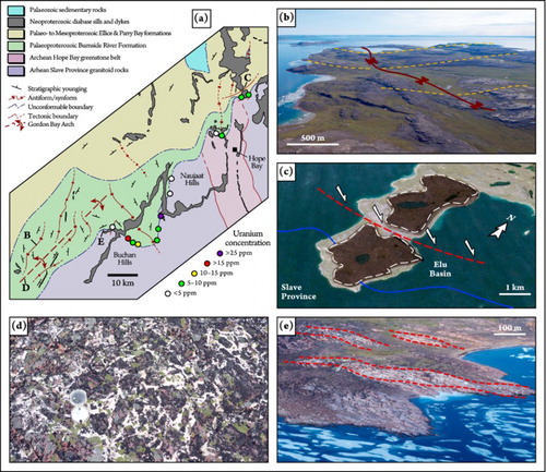
Elu Inlet and Melville Sound encompass a large marine embayment (130 by 40 km) of Bathurst Inlet lying to the south of Kent Peninsula, on the northern Canadian mainland in the Kitikmeot Region of Nunavut ((a,b)). This remote and virtually uninhabited area, roughly centered on 68° 20′ N – 106° 45′ W, is typified by rolling tundra-covered hills and coastal landscapes that contain broad exposures of Precambrian rocks polished by Pleistocene glaciations. The closest community is Cambridge Bay, which is located on southern Victoria Island, approximately 60 km to the northeast of Elu Inlet. The study area also hosts an active gold-mining project at Hope Bay ((b)). Exploratory geological fieldwork conducted during the 1970s and 1980s (CitationCampbell, 1978, Citation1979; CitationCampbell & Cecile, 1979, Citation1981; CitationMcCormick, 1992; CitationMcCormick & Grotzinger, 1992) established the lithostratigraphic and chronostratigraphic definition of the major sedimentary successions in the area. In the summers of 2014 and 2015, a thematic-mapping project was undertaken, focused on advanced sedimentologic, stratigraphic, and geophysical investigations of wide exposures of ancient fluvial, aeolian, and shallow-marine deposits in the area (CitationIelpi & Rainbird, 2015a; CitationIelpi, Rainbird, Greenman, & Creason, 2015; CitationRainbird & Ielpi, 2015). The project aimed to fill one of the large existing gaps in the geological knowledge of northern Canada. Despite its remoteness, the region hosts one of the largest gold deposits in Canada (CitationSherlock et al., 2012), and promising anomalies of natural radioactivity are present, which are likely related to uranium mineralization. The scope of this work is to present a comprehensive geological map of Elu Inlet and Melville Sound, stemming from the results of the 2014–2015 field seasons. This paper serves as illustrative notes for the attached geological map (Main Map), and introduces an updated physical stratigraphic and structural framework for the study area.
Figure 1. Geographic and geological background. (a) Location of the study area, with major structural and basinal features reported. (b) Summary geological sketchmap of the study area.
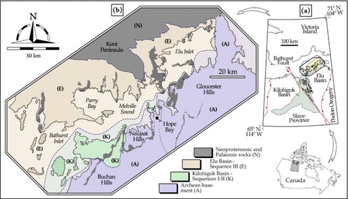
Along the coastlines of Elu Inlet and Melville Sound, glacially polished exposures of Palaeoproterozoic to early Palaeozoic sedimentary rocks unconformably overlie basement of Archean crystalline rocks ((b)). Basement crystalline rocks are part of the Bathurst Block of the Slave Province, a major building block of Laurentia (CitationHoffman, 1988), and date to 2.7–2.6 Ga (derived from various crystallization and metamorphic ages; see CitationBevier & Gebert, 1991). Overlying sedimentary rocks include the northeastern reach of the 1.9–1.6 Ga Kilohigok Basin, the unconformably overlying rocks of 1.6–1.2 Ga Elu Basin (U-Pb ages derived from several ash beds; see CitationBowring & Grotzinger, 1992), 720 Ma mafic rocks (U-Pb ages derived from gabbro sills and diabase; see CitationHeaman, LeCheminant, & Rainbird, 1992), and sediments of suspected early Palaeozoic age (CitationO’Neill, 1924; CitationThorsteinsson & Tozer, 1962). Previously interpreted as either an aulacogen or intracratonic trough (CitationCampbell & Cecile, 1979, Citation1981; CitationHoffman, 1973), the large Kilohigok Basin is currently interpreted to represent a foreland basin related to the accretion and northwest-ward migration of the ∼2.0 Ga Thelon Orogen (CitationMcCormick & Grotzinger, 1992; CitationTirrul, 1985; CitationTirrul & Grotzinger, 1990), which is located approximately 150 km to the southeast ((a)). Regionally, the lower part consists of Kilohigok Basin fill and is composed of nearshore-marine facies, whilst the upper consists of fluvial facies. The northeastern portion of Kilohigok Basin, which is exposed in the map region ((a)), is however entirely represented by continental deposits. The rocks composing Elu Basin are exposed along Elu Inlet, Melville Sound, and its northern extension, Parry Bay ((b)). Elu Basin was interpreted as the product of an intracontinental rift (CitationCampbell, 1979) and reappraised as the fill of an intracratonic-sag basin (CitationRainbird, Ielpi, Long, & Donaldson, 2014), possibly a far-field effect of the Trans-Hudson Orogeny to the southeast (cf. CitationArmitage & Allen, 2010).
2. Methods
The study area is between 68° 45′ N – 105° 10′ W and 67° 45′ N – 108° 50′ W and was mapped in July 2014 and June-July 2015. Field mapping followed remote predictive mapping that employed RapidEye™ and Pleiades™ satellite imagery. Mapping notes were directly drawn on 1:10,000 and 1:25,000 vector topographic basemaps derived from the National Topographic System (NTS) sheets 76N, 76O, 77A, and 77B, and then transcribed to 1:200,000 scale.
Sedimentologic and stratigraphic methods consisted of facies analysis and bed-by-bed logging of selected exposures. Sedimentologic details beyond the scope of this work are published in CitationIelpi and Rainbird (2015b, Citation2016), from which the stratigraphic scheme was adopted. The stratigraphic organizations are based on the identification of informal stratigraphic sequences, that is, packages of sedimentary rocks bounded by basin-scale surfaces of unconformity (CitationSalvador, 1987). The stratigraphic sequences recognized in this study bear supra-regional significance, since they have been correlated to other autochthonous sedimentary basins within Laurentia (CitationRainbird & Davis, 2007; CitationRainbird, Stern, Rayner, & Jefferson, 2007). Sequences are numbered from the bottom with roman numerals and contain lithostratigraphic units that consist of formalized formations. Formations may in turn include informal members, introduced in this study. Formations and members are coded on the map with a capital letter indicating their age and two lower-case letters abbreviating their name.
Geophysical mapping consists of analysis of natural radioactivity with a Radiation Solutions™ RS-125 mass spectrometer; geophysical details are beyond the scope of this work but can be found in CitationIelpi and Rainbird (2015a) and CitationIelpi et al. (2015). Structural methods consisted of identification and mapping of folds and faults, at both outcrop and map scales. The recognition of faults with cartographic extent but poor outcrop expression was aided by recognition of stratigraphic separation along lineaments. Broad open folds were recognized from the air and through collection of bedding attitude at several locations. Quaternary deposits and landforms related to glacial morphogenetic processes have not been mapped in this study, although these aspects have been considered in the southwestern portion of the current study area by CitationKerr and Knight (2001).
3. Stratigraphy
3.1. Archean Slave Province
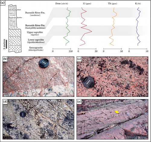
The stratigraphy of the study area is characterized in its lowermost part by Archean units that represent the bedrock of the Elu and Kilohigok basins. Archean rocks outcrop in the southern and eastern portions of the study area and belong to the Slave Craton (CitationBevier & Gebert, 1991). These rocks contain a number of lithotypes that can be grouped into granitoid and greenstone-belt rocks. Granitoid rocks (map code Agt; (a)) include a suite of acidic intrusions (syeno- and biotite granite suites, monozodiorite, and subordinate tonalites; CitationMvondo, Lentz, & Bardoux, 2012). Granitoid rocks contain mafic xenoliths and are cross-cut by minor intrusive bodies of gabbro that are sub-cartographic scale (coded with the Greek letter ‘γ’ in the map). Granitoid rocks are also cross-cut by decimeter-scale mylonitic bands represented by gneiss ((a)). In proximity to the nonconformity with Proterozoic sedimentary rocks, an alteration profile interpreted to represent sub-aerial palaeo-weathering is developed at a thickness of up to 10 m. This horizon, termed ‘Kilohigok Palaeosol’ in CitationIelpi et al. (2015) displays a zonation from fresh to saprolitic granitoid rock characterized by a progressive depletion in labile minerals and enrichment in sericite ((a–d)). Of particular interest is the lower portion of the saprolite layer, which is red-stained by iron oxide and yields above-baseline concentrations of uranium (up to 30 ppm; (a)).
Figure 2. Field aspects of the Archean Slave Province and the deposits of Sequences I–II. Field book, for scale, in (a–c) is approximately 20 cm long. (a) Syenogranite composing the granitoid bedrock of Kilohigok and Elu basins, with a minor shear band consisting of mylonitic gneiss (within dashed lines). (b) Highly deformed, pelitic meta-sediments, part of the Hope Bay greenstone belt. (c) Cross-bedded arkosic sandstone belonging to the Burnside River Formation, Sequence I. (d) Cross-bedded pebble-conglomerate composing the basal gravelly member of the Burnside River Formation. Lens cap (circled), for scale, is 5 cm across. (e) Mineralogically and texturally mature quartzarenite with frosted grains, part of the aeolian member of the Burnside River Formation. Pencil, for scale, is approximately 15 cm long. (f) Disorganized sedimentary breccia part of the Tinney Cove Formation, Sequence II. Note sandstone clasts derived the older Burnside River Formation. Hammer, for scale, is approximately 25 cm long.
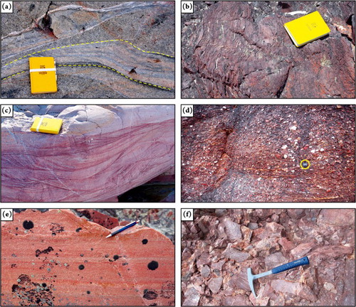
Figure 3. Stratigraphic examples and field aspects of profiles of alteration (Kilohigok palaeosol) developed across the nonconformity between the Archean Slave Province and the Burnside River Formation. Lens, for scale, in (b–d) is 5 cm across. (a) Kilohigok palaeosol at Buchan hills, see (a) for location; note peak of uranium mineralization along the lower saprolite horizon. Abbreviations: hematite (Hem); k-feldspar (Kfs); muscovite (Ms); plagioclase (Pl); quartz (Qz); and sericite (Ser). (b) Fresh syenogranite occurring below the palaeosol layer. (c) Lower saprolite, showing reddening due to iron oxide. (d) Upper saprolite, showing intense sericitization and depletion of weak minerals. (e) Lowermost deposits of the Burnside River Formation, showing dark coloring due to ferric and potassic alteration.
Greenstone-belt rocks (map code Agb) consist of heterogeneous assemblages of mafic meta-volcanic and intrusive products, with intercalated clastic meta-sedimentary rocks ((b)). Greenstone-belt rocks occur along structural trends that define the Hope Bay and Elu greenstone belts (CitationSherlock et al., 2012), which also host major deposits of gold. Palaeo-weathering profiles beneath Proterozoic basin strata on greenstone-belt rocks are poorly developed and do not yield significant amounts of radioactive nuclides.
3.2. Kilohigok Basin, Sequence I
The lowermost stratigraphic sequence in the study area belongs to the fill of the northeastern Kilohigok Basin and is dated to 1963–1882 Ma (ages from CitationBowring & Grotzinger, 1992). This sequence sits nonconformably on the Archean Slave Province and is overlain by deposits of Sequence II and III with markedly angular unconformity. In the map area, Sequence I is entirely represented by the Burnside River Formation (map code Pbr), a sandstone-dominated unit widely exposed in the south-western portion of the study area. The Burnside River Formation attains a maximum thickness of approximately 1 km in the study area, and progressively narrows in the northeast-ward direction, eventually tapering off along Elu Inlet. The Burnside River Formation is ubiquitously cross-bedded ((c)), pointing to deposition in a fluvial environment. Red-staining due to abundant iron oxide is common, whilst the lowermost deposits sitting atop palaeosol layers also display purple-greenish coloring due to ferric and potassic alteration ((e)). Large-scale compound cross-bedding interpreted as broad channel forms corroborate the hypothesis of fluvial origin and point to the coalescence of fluvial bars in mature channel belts (cf. CitationIelpi & Ghinassi, 2015).
Two informal members have been identified in the Burnside River Formation. A coarse-grained, conglomeratic member occurs along erosional depressions at sub-cartographic scale carved on basement rocks, north of Hope Bay ((d)). This conglomerate (coded with the symbol ‘*’ on the map) attains a maximum thickness of ∼10 m, appears cross-bedded, and is locally derived from greenstone-belt rocks, suggesting that small incised valleys were filled with proximal fluvial deposits. A mineralogically very mature sandstone exhibiting quartz-grain frosting ((e)) is cross-bedded in large foreset strata with bedsets up to 30 m in height (map code Pba). These strata, interpreted as aeolian deposits, are up to 50 m thick and outcrop at three sites north of the Buchan Hills ((b)). Their occurrence within the Burnside River Formation is particularly relevant given the rarity of aeolian deposits older than 1.8 Ga (CitationEriksson et al., 1998).
3.3. Kilohigok Basin, Sequence II
Sequence II, loosely bracketed between 1882 and 1630 Ma (ages from CitationBowring & Grotzinger, 1992), represents the upper fill of the Kilohigok Basin and lies unconformably between Sequences I and III. Sequence II, represented by the Tinney Cove Formation (map code Ptc) outcrops at one locality north of Hope Bay, where it is exposed for a thickness of approximately 30 m along a rocky cliff at sub-cartographic extent. It consists of a coarse-grained, clast-supported, and disorganized sedimentary breccia interspersed with a coarse sandy matrix ((f)). All the clasts are locally derived from the underlying Burnside River Formation. The Tinney Cove breccia is interpreted as slope deposits, developed at local topographic breaks along the unconformity with Sequence I. Slightly above-baseline values of radioactivity have been reported across and just above this unconformity (CitationCampbell, 1979; CitationIelpi & Rainbird, 2015a).
3.4. Elu Basin, Sequence III
Sequence III is widely exposed in the north-western portion of the map area and comprises deposits dated from 1630 to 1270 Ma (ages from CitationBowring & Grotzinger, 1992). It overlies Sequences II and III in the western part of the map area, and nonconformably overlies Slave Province rocks towards the north-east. Sequence III comprises the fill of the Elu Basin, which consists of the Ellice and Parry Bay formations. The Ellice Formation (map code Pel) is exposed along a wide belt that runs through most of the study area and pinches out toward the southwest. Based on mapping projections, the thickness of the Ellice Formation exceeds 1 km in the study area. It is dominated by coarse- to medium-grained sandstone in its lower half (up to ∼450 m thick), and by fine-grained sandstone alternated with mudstone and dolostone in its upper half (up to ∼550 m thick). Minor granite-clast conglomerate is developed where the Ellice Formation sits directly on the Archean Slave Province. Sandstone-dominated deposits are mineralogically mature, ubiquitously cross-bedded, and contain in places large channel and bar forms ((a,b)), together suggesting deposition in a fluvial environment (CitationIelpi & Rainbird, 2015b). Two informal members are identified in the Ellice Formation. A quartzarenite with grain frosting and large-scale foreset stratification (with bedsets up to 40 m in height; (c)) composes an aeolian member (map code Pea). Aeolian member strata are up to 60 m thick and were observed at two sites along the northeast side of Elu Inlet ((b)). Stratigraphically overlying mudstone and intercalated dolostone, they are mapped as a separate member (map code Pen). These deposits are thinly interbedded and contain small cross-sets and decimeter-scale carbonate mounds ((d)), the latter interpreted as stromatolites (CitationCampbell, 1979). These features together point to deposition in a fluvially influenced nearshore-marine environment (cf. CitationIelpi, 2013).
Figure 4. Field aspect of Sequence III and younger rocks of Neoproterozoic to Palaeozoic age. Field book, for scale, in (b, d, and e) is approximately 20 cm long. (a) Large-scale planar and inclined beds related to channel and bars forms, Ellice Formation. Geologist, for scale, is approximately 1.8 m tall. Note diabase related to the Franklin Large Igneous Province in the upper cliff. (b) Detail of cross-bedding (dashed lines) in fluvial sandstone, Ellice Formation. (c) Large-scale foreset strata of quartzarenite (dashed lines), aeolian member of the Ellice Formation. Foreground is approximately 300 m wide. (d) Alternating small-scale cross-beds in fine-grained sandstone and mudstone (lower arrow) and dolostone showing low-relief stromatolite forms (upper arrow), nearshore-marine member of the Ellice Formation. (e) Well-developed stromatolite forms in dolostone, Parry Bay Formation. (f) Fluvial sandstone of suspected Cambrian-Ordovician age, showing meso-scale channel cuts (dashed lines). Cliff in the foreground is approximately 20 m wide.
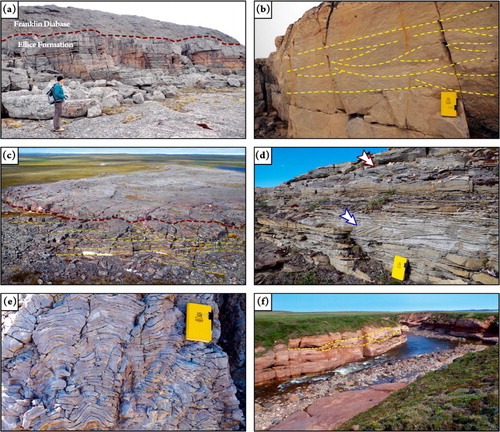
The Parry Bay Formation (map code Mpb) is an up to 800 m thick, dolostone-dominated unit, mainly exposed in the north-western portion of the map area. It is gradational with the mainly terrigenous deposits of the underlying nearshore-marine member of the Ellice Formation. Tabular beds of dolostone contain high-relief mounds with sub-metric to metric wavelength ((e)), which are interpreted as stromatolites (CitationCampbell, 1979). Thin beds of mudstone occur sporadically. At one location in northern Parry Bay, dolostone and minor mudstone are laminated in concentric and cuspate stromatolite forms, mapped as a separate member (map code Mpc). This member bears resemblance to the Sulky Formation of the Dismal Lake Group, which contains possibly deep-water Conophyton stromatolites (cf. CitationHoffman, 1974; CitationCampbell, 1979) and is thus tentatively related to a deep-marine realm.
3.5. Neoproterozoic and Paleozoic rocks
The deposits belonging to Sequences I–III are at various localities cross-cut and covered by younger rocks of intrusive and sedimentary origin, respectively. Intrusive rocks (map code Nfd) consist of diabase and gabbro sills and dykes related to the Franklin Large Igneous Province (CitationHeaman et al., 1992). The largest sills of diabase, in the order of 80–100 m thick, occur along the promontories that divide Elu Inlet from Melville Sound ((a)). Minor dykes and sills that cross-cut the Parry Bay Formation are surrounded by distinctive thermal aureoles associated with the metasomatism of dolostone into dolomitic marble.
Sedimentary deposits of suspected Cambrian to Ordovician age (CitationO’Neill, 1924; CitationThorsteinsson & Tozer, 1962) unconformably overlie Proterozoic strata of the Elu Basin Sequence III in the north-east part of the map area. Further east they lie nonconformably over crystalline rocks of the Archean Slave Province. These Cambrian-Ordovician rocks (map code Cfr) consist of arkosic sandstone and minor interspersed mudstone that show ubiquitous cross-bedding and meso-scale channel and bar forms ((f)). Sandstone and mudstone are red-stained by iron oxide, weakly cemented, and bear resemblance to the Old Fort Island Formation exposed in the Duke of York Inlier of southern Victoria Island (CitationRainbird, LeCheminant, & Lawyer, 1996), thus suggesting deposition in a fluvial environment.
4. Structural features
The study area contains tectonic terranes and overlying basin fills that display different structural styles. The Slave Province consists of a tectonic assemblage of orogenic-related intrusions and intervening supracrustal terranes (greenstone belts) (CitationPadgham & Fyson, 1992). Most of the granitoid rocks in the study area display relatively limited deformation, which is typically concentrated along meso-scale shear zones ((a)). Greenstone-belt domains are constrained by regional tectonic boundaries, and internally characterized by intense, polyphase deformation that resulted in steep to recumbent isoclinal folding ((b)). Fold structures are further dissected and juxtaposed by tectonic surfaces (CitationMvondo et al., 2012; CitationSherlock et al., 2012) that have not been reported on the map for the sake of graphical clarity.
The strata of Sequence I attain attitudes that vary in between 0° and 30° and have a general northwest-ward younging direction. These strata are part of broad, open folds that range in wavelength from 5 to 20 km ((a)), the limbs of which rarely exceed 15° in steepness. Most folds are hardly discernible from the ground and are apparent only at map scale ((b)). In the south-western study area, fold axes have a dominant strike of 020°–040°, in a direction sub-parallel to the Gordon Bay Arch ((a)), a regional arch that has been related to accretion and foreland-ward migration of the Thelon Orogen (CitationMcCormick & Grotzinger, 1992). The structural control of the Gordon Bay Arch becomes progressively less apparent toward the north-east, where folds attain axial strike of 330°–020° ((a)). The northwest-striking folds also involve the surface of nonconformity with the Archean Slave Province and are apparently related with higher-than-normal concentrations of uranium ((a); CitationIelpi et al., 2015). All folds become gentler upward, such that Sequences II and III form monoclines that dip shallowly toward the north-northwest, and that are only slightly deformed by folds propagating from the underlying Sequence I.
Figure 5. Structural aspects of the study area. (a) Structural sketchmap of the area underlying Melville Sound and the Buchan and Naujaat hills; note the northeastern termination of the Gordon Bay Arch; the occurrence of broad folds and isolated normal faults; and the spatial relationships between folds and uranium mineralization along the nonconformity between Sequence I and the Archean Slave Province. (b) Aerial oblique view of a broad, open syncline composed of strata belonging to the Burnside River Formation (note axial trace), northern Bathurst Inlet, looking south. (c) Google Earth™ oblique image of the promontory in between Elu Inlet from Melville Sound, showing a 10-km-scale normal fault (dashed line) with vertical displacement in the order of ∼200 m. (d) Detail of a brecciated fault zone hosted within sandstone of the Ellice Formation. Note tension gashes recrystallized with quartz. Compass, for scale, is approximately 15 cm across. (e) Large-scale tension gash (delimited by dashed lines) affecting the Burnside River Formation, northern Bathurst Inlet, looking northwest.
Normal and transtensional faults with 3–15 km of along-strike separation ((c)), and maximum vertical displacement in the order of ∼200 m (extrapolated from stratigraphic relationships between adjacent exposures) are tentatively associated to the Bathurst Fault ((a); CitationCampbell, 1979; CitationCampbell & Cecile, 1979), a regional-scale lineament displacing the central Kilohigok Basin. Larger fault zones are associated with the development of intense tensional jointing, which generated brecciated tension gashes filled with quartz ((d)). Larger tension gashes may extend for as much as 1 km in length and 100 m in width ((e)). Finally, younger deposits of Neoproterozoic to Palaeozoic age lie virtually flat and do not appear to be influenced by folding or faulting.
5. Conclusions
Helicopter-supported, field-based geological mapping was conducted in conjunction with sedimentological, stratigraphic, and geophysical studies in a relatively underexplored area centered on Elu Inlet and Melville Sound, in the Kitikmeot Region of Nunavut. The area is underlain by an Archean crystalline basement overlain by a succession of several sedimentary sequences ranging in age from Palaeoproterozoic to early Palaeozoic. While the general chronostratigraphic subdivision of the sedimentary sequences is unchanged, this study introduces an updated sedimentologic, physical stratigraphic, and geophysical framework for the area.
Three main Proterozoic sedimentary sequences are recognized, being separated by unconformable surfaces in places displaying angularity. The oldest Sequence I pertains to the northeastern portion of the larger Kilohigok Basin and contains a thick fluvial to aeolian unit (Burnside River Formation) that locally overlies a regionally developed palaeo-weathering profile. Field-based mass-spectrometry reveals that, in places, this palaeosol hosts anomalous concentrations of uranium. The overlying Sequence II represents the northeastern part of the Kilohigok Basin and is composed of the slope-derived Tinney Cove Formation. Above-baseline levels of radioactivity have been observed along the unconformity between Sequences I and II. Sequence III belongs to Elu Basin and comprises the fluvial–aeolian to nearshore-marine Ellice Formation, and the marine Parry Bay Formation. Proterozoic sequences are cross-cut by diabase sills and dykes of the Franklin Large Igneous Province and are unconformably overlain by sedimentary deposits of suspected Cambrian-Ordovician age.
The study area reveals several structural styles. Greenstone belts within the Archean Slave Province display intense and polyphase deformation, while unconformably overlying Proterozoic deposits are only weakly deformed. Sequence I shows broad, gentle folding related at least in part to the growth of the Gordon Bay Arch, a basement-hosted uplift with regional extent. Sequences II and III compose virtually undisturbed monoclines. Sporadic post-depositional faults point to normal to transtensional kinematics and are associated with the local development of wide tension gashes filled by quartz. Neoproterozoic to Palaeozoic rocks show no apparent deformation. Our structural observations are in agreement with earlier literature, with Kilohigok Basin representing the foreland of the Thelon Orogen, and Elu Basin likely generated by intracratonic thermal sagging.
Software
Esri ArcMap 9.1 and Adobe Photoshop CS3 were used for producing the topographic basemap. Macromedia Freehand MX was used for map digitalization and for diagram preparation.
Geology of Elu Inlet and Melville Sound, Nunavut, Arctic Canada.pdf
Download PDF (22 MB)Acknowledgements
We would like to acknowledge the help of late Dr Fred Campbell (1944–2015), who provided us with critical input during the initial phase of logistical planning. TMAC Resources kindly provided logistical support and a comfortable base of operations at their Doris North facility. The project also benefited from the logistical support of the Polar Continental Shelf Program at Resolute, Air Tindi and Discovery Mining Services. Dennis Rausch, Dave Bell, Zach Dippo and Fred Jones of Great Slave Helicopters are thanked for safe piloting. Reviewers Danielle Thomson and Jennifer Carrel provided critical comments that improved the manuscript and map. Research co-supported by the Canadian Northern Economic Development Agency’s (CanNor) Strategic Investments in Northern Economic Development (SINED) program, the second phase of the Geo-mapping for Energy and Minerals (GEM-2) program, and by a Natural Sciences and Engineering Research Council Visiting Research Fellowship to AI.
Disclosure statement
No potential conflict of interest was reported by the authors.
Related Research Data
References
- Armitage, J. J., & Allen, P. (2010). Cratonic basins and the long-term subsidence history of continental interiors. Journal of the Geological Society, London, 167, 61–70. doi: 10.1144/0016-76492009-108
- Bevier, M. L., & Gebert, J. S. (1991). U–Pb geochronology of the Hope Bay – Elu Inlet area, Bathurst Block, northeastern Slave structural province, northwest territories. Canadian Journal of Earth Sciences, 28, 1925–1930. doi: 10.1139/e91-173
- Bowring, S. A., & Grotzinger, J. P. (1992). Implications of new chronostratigraphy for tectonic evolution of Wopmay Orogen, northwest Canadian Shield. American Journal of Science, 292, 1–20. doi: 10.2475/ajs.292.1.1
- Campbell, F. H. A. (1978). Geology of the Helikian rocks of the Bathurst Inlet area, Coronation Gulf, Northwest Territories. Geological Survey of Canada, Current Research, 78-1A, 97–106.
- Campbell, F. H. A. (1979). Stratigraphy and sedimentation in the Helikian Elu Basin and Hiukitak Platform, Bathurst Inlet– Melville Sound, Northwest Territories. Geological Survey of Canada, Paper, 79-8, 1–19.
- Campbell, F. H. A., & Cecile, M. P. (1979). The northeastern margin of the Aphebian Kilohigok Basin, Melville Sound, Victoria Island, District of Franklin. Geological Survey of Canada, Current Research, 79-1A, 91–94.
- Campbell, F. H. A., & Cecile, M. P. (1981). Evolution of the Early Proterozoic Kilohigok Basin, Bathurst Inlet–Victoria Island, Northwest Territories. Geological Survey of Canada, Paper, 81-10, 103–131.
- Eriksson, P. G., Condie, K. C., Tirsgaard, H., Mueller, W. U., Altermann, W., Miall, A. D., … Chiarenzelli, J. R. (1998). Precambrian clastic sedimentation systems. Sedimentary Geology, 120, 5–53. doi: 10.1016/S0037-0738(98)00026-8
- Heaman, L. M., LeCheminant, A. N., & Rainbird, R. H. (1992). Nature and timing of Franklin igneous events, Canada: Implications for a Neoproterozoic mantle plume and the break-up of Laurentia. Earth and Planetary Science Letters, 109, 117–131. doi: 10.1016/0012-821X(92)90078-A
- Hoffman, P. F. (1973). Evolution of an early Proterozoic continental margin: The Coronation geosyncline and associated aulacogens of the northwestern Canadian Shield. Philosophical Transactions of the Royal Society A: Mathematical, Physical and Engineering Sciences, 237, 547–581. doi: 10.1098/rsta.1973.0017
- Hoffman, P. F. (1974). Shallow and deepwater stromatolites in lower Proterozoic platform-to-basin facies change, Great Slave Lake, Canada. American Association of Petroleum Geologists, Bulletin, 58, 856–867.
- Hoffman, P. F. (1988). United plates of America, the Birth of a craton: Early Proterozoic Assembly and growth of Laurentia. Annual Review of Earth and Planetary Sciences, 16, 543–603. doi: 10.1146/annurev.ea.16.050188.002551
- Ielpi, A. (2013). Frequency-reliant correlative patterns of asymmetric lacustrine-paralic sequences: A genetic approach to the late Miocene Bithynia Marlstones of the south-eastern Volterra Basin, Italy. Journal of Sedimentary Research, 83, 377–394. doi: 10.2110/jsr.2013.31
- Ielpi, A., & Ghinassi, M. (2015). Planview style and palaeodrainage of Torridonian channel belts: Applecross Formation, Stoer Peninsula, Scotland. Sedimentary Geology, 325, 1–16. doi: 10.1016/j.sedgeo.2015.05.002
- Ielpi, A., & Rainbird, R. H. (2015a). Geological framework of the 1.9–1.6 Ga Elu Basin, western Nunavut: Representative sedimentology, gamma-ray spectrometry and lithogeochemistry. Canada-Nunavut Geoscience Office, Summary of Activities, 2014, 89–96.
- Ielpi, A., & Rainbird, R. H. (2015b). Architecture and morphodynamics of a 1.6 Ga fluvial sandstone: Ellice formation of Elu Basin, Arctic Canada. Sedimentology, 62, 1950–1977. doi: 10.1111/sed.12211
- Ielpi, A., & Rainbird, R. H. (2016). Reappraisal of precambrian sheet-braided rivers: Evidence for 1.9 Ga deep-channelled drainage. Sedimentology, 63, 1550–1581. doi: 10.1111/sed.12273
- Ielpi, A., Rainbird, R. H., Greenman, J. W., & Creason, C. G. (2015). The 1.9 Ga Kilohigok paleosol and Burnside River Formation, western Nunavut: Stratigraphy and gamma-ray spectrometry. Canada-Nunavut Geoscience Office, Summary of Activities, 2015, 1–10.
- Kerr, D. E., & Knight, R. D. (2001). Surficial geology, Koignuk River, Nunavut. Geological Survey of Canada, Series A Map, 1998A. doi:10.4095/212883
- McCormick, D. S. (1992). Evolution of an early Proterozoic alluvially-dominated foreland basin, Burnside Formation, Kilohigok Basin, N.W.T., Canada (Ph.D. thesis). Massachusetts Institute of Technology, Cambridge, Massachusetts, p. 547.
- McCormick, D. S., & Grotzinger, J. P. (1992). Evolution and significance of an overfilled alluvial foreland basin: Burnside formation (1.9 Ga), Kilohigok Basin, N.W.T., Canada. Basin Research, 4, 253–278. doi: 10.1111/j.1365-2117.1992.tb00048.x
- Mvondo, H., Lentz, D., & Bardoux, M. (2012). Stratigraphy and geochemistry of the igneous rocks in the Elu Link between Hope Bay and Elu greenstone belts, northeast Slave craton: Tectonic setting and implications for gold mineralization. Canadian Journal of Earth Sciences, 50, 148–170. doi: 10.1139/cjes-2012-0092
- O’Neill, J. J. (1924). Geology of the Arctic coast of Canada, west of Kent Peninsula (Report of the Canadian Arctic Expedition 1913–18, 11-Part A, p. 107). F.A. Acland.
- Padgham, W. A., & Fyson, W. K. (1992). The slave province: A distinct Archean craton. Canadian Journal of Earth Sciences, 29, 2072–2086. doi: 10.1139/e92-165
- Rainbird, R. H., & Davis, W. J. (2007). U-Pb detrital zircon geochronology and provenance of the late Paleoproterozoic Dubawnt Supergroup; linking sedimentation with tectonic reworking of the western Churchill Province, Canada. Geological Society of America, Bulletin, 119, 314–328. doi: 10.1130/B25989.1
- Rainbird, R. H., & Ielpi, A. (2015). Reconnaissance geological mapping and thematic studies of the Elu Basin, Nunavut. Geological Survey of Canada, Open File, 7730, 10. Natural Resources Canada, Ottawa, Ontario, Canada.
- Rainbird, R. H., Ielpi, A., Long, D. G. F., & Donaldson, J. A. (2014). Similarities and paleogeography of late Paleoproterozoic terrestrial sandstone deposits on the Canadian Shield: Product of Hudsonian orogenesis. Geological Society of America, Abstract with Programs, 46, 89. Geological Society of America, Boulder, Colorado, USA.
- Rainbird, R. H., LeCheminant, A. N., & Lawyer, J. I. (1996). The Duke of York and related Neoproterozoic inliers of southern Victoria Island, District of Franklin, Northwest Territories. Geological Survey of Canada, Current Research, 1996E, 125–134.
- Rainbird, R. H., Stern, R. A., Rayner, N. M., & Jefferson, C. W. (2007). Age, provenance, and regional correlation of the Athabasca Group, Alberta and Saskatchewan, constrained by igneous and detrital zircon geochronology. Geological Survey of Canada, Bulletin, 588, 193–209.
- Salvador, A. (1987). Unconformity bounded stratigraphic units. Geological Society of America, Bulletin, 98, 232–237. doi: 10.1130/0016-7606(1987)98<232:USU>2.0.CO;2
- Sherlock, R. L., Shannon, A., Hebel, M., Lindsay, D., Madsen, J., Sandeman, H., … Friedman, R. (2012). Volcanic stratigraphy, geochronology, and gold deposits of the Archean Hope Bay greenstone belt, Nunavut Canada. Economic Geology, 107, 991–1042. doi: 10.2113/econgeo.107.5.991
- Thorsteinsson, R., & Tozer, E. T. (1962). Banks, Victoria and Stefansson Islands, Arctic Archipelago. Geological Survey of Canada, Memoir, 330, 1–85.
- Tirrul, R. (1985). Nappes in the Kilohigok Basin, and their relation to the Thelon tectonic zone, District of Mackenzie. Geological Survey of Canada, Current Research, 85-1A, 407–420.
- Tirrul, R., & Grotzinger, J. P. (1990). Early Proterozoic collisional orogeny along the northern Thelon tectonic zone, Northwest Territories, Canada: Evidence from the foreland. Tectonics, 9, 1015–1036. doi: 10.1029/TC009i005p01015