
ABSTRACT
This paper presents a coastal geomorphology map of some of the Chilean region of the Straits of Magellan, and is based on a combined geomorphological and sedimentological approach applicable to a larger section of the coast. The mapped area is located in Tierra del Fuego between the Segunda Angostura of the Straits of Magellan and Bahía Inútil. A detailed geomorphological map was compiled at a scale of 1:50,000, describing a sequence of 4 marine and transitional (glacio-lacustrine to marine) terrace orders and raised marine shorelines found between 0 and + 20 m. These features are mainly linked to glacio-eustasy and secondarily to Holocene neo-tectonics. This research derives from the interpretation of aerial photographs and remote sensing imagery along with geomorphological-stratigraphic field surveys and geochemical data. The Main Map illustrates an area with dominant palaeo-glacial and glacio-lacustrine morphology with extensive lacustrine deposits and well-developed lake systems characterising the Porvenir region.
1. Introduction
Understanding the distribution of Pleistocene–Holocene marine terraces and raised shorelines is a fundamental tool for the reconstruction of palaeogeography and glacio-isostatic/neo-tectonic evolution of a geologically complex area (Patagonia and Tierra del Fuego). In fact, the present tectonic setting of the Tierra del Fuego region describes the relative movements and interactions between three main plates: Antarctica, South America and Scotia (CitationBurns, Rickard, Belbin, & Chamalaun, 1980; CitationCunningham, Klepeis, Gose, & Dalziel, 1991; CitationDalziel, Kligfield, Lowrie, & Opdyke, 1973; CitationLodolo, Menichetti, Tassone, & Sterzai, 2002; CitationMenichetti, Lodolo, & Tassone, 2008). Other authors (CitationBujalesky, Coronato, & Rabassa, 2004) noted that the coasts of the Magellan Straits and Beagle Channel have been affected by different types of uplift (tectonic uplift and glacio-isostatic rebound). Evidence of recent tectonic activity is also documented in the literature, especially on the Pacific side of the Strait of Magellan (CitationBartole, Colizza, De Muro, & Colautti, 2000). Strike slip faults linked to the complex dynamics of the collisional margin of the Southern Chilean plate are well known, but extensional (Pull Apart basins) phenomena are also linked to these settings (CitationLodolo et al., 2003). However, the south-eastern coast of Patagonia and the north eastern coast of Tierra del Fuego are considered mostly tectonically stable during the Holocene (CitationSchellmann & Radtke, 2010) and the Holocene palaeogeography of the area is deemed to be mainly controlled by glacio-isostatic readjustment, with subsequent mild tectonic activity resulting from deglaciation (CitationDe Muro, Kalb, Brambilla, & Ibba, 2012; CitationRabassa et al., 1992; CitationWinslow & Prieto, 1991). Little evidence of this activity is visible on land (CitationDe Muro, Di Grande, Brambati, & Ibba, 2015). As previously observed (CitationSchellmann & Radtke, 2010), the relative marine ingression that produced terraced sequences along the coast and inland is likely to be linked to uplift of the coastal system following final deglaciation of the region. Isostatic rebound probably occurred rather late compared to post-glacial transgression, and this uplift is superimposed on to the local geological setting in a complex manner that is currently not entirely understood (CitationBrambati, De Muro, & Di Grande, 1998), and further studies are required in order to understand this process more fully.
In the Patagonia Fuegian region, marine terrace deposits have historically attracted the attention of many researchers (CitationAguirre, Richiano, & Sirch, 2006; CitationAndersson, 1906; CitationAuer, 1974; CitationBentley & McCulloch, 2005; CitationBujalesky, & Gonzales Bonorino,1990; CitationCodignotto, 1984; CitationFeruglio, 1933; CitationGordillo, Coronato, & Rabassa, 1990; CitationHalle, 1910; CitationMarkgraf, 1980; CitationMörner, 1987; CitationPorter, Clapperton, & Sudgen, 1992; CitationPorter, Stuiver, & Heusser, 1984; CitationRabassa et al.1992; CitationRabassa, Serrat, Marti, & Coronato, 1988; CitationUrien, 1966), however, the geomorphology of the area described in this paper is still largely unknown, particularly when discussing the contiguous spatial distribution of four orders of Holocene terraces of marine and transitional origin. Most of the previous studies described, sometimes with great accuracy, the glacial evolution of this region and associated geomorphological features (CitationBenn & Clapperton, 2000; CitationBentley, Sugden, Hulton, & McCulloch, 2005; CitationDarvill, Stokes, Bentley, & Lovell, 2014; CitationDarvill, Stokes, Bentley, Evans, & Lovell, 2016; CitationGlasser & Jansson, 2008; CitationLovell, Stokes, & Bentley, 2011; CitationLovell, Stokes, Bentley, & Benn, 2012; CitationMcCulloch & Davies, 2001) with some reference to Holocene paleo shoreline and other coastal landforms (CitationIsla & Bujalesky, 2008; CitationRostami, Peltier, & Mangini, 2000). However, the previous literature did not complete coastal geomorphological mapping of the area discussed herein but focused on single outcrops relevant to the interpretation of regional glacial evolution (CitationBenn & Clapperton, 2000; CitationSchellmann & Radtke, 2003). Other geological–geomorphological regional studies carried out in the Straits of Magellan (CitationBrambati, Fontolan, & Simeoni, 1991) allowed morphostructural units (CitationBartole et al., 2001; CitationBartole, De Muro, Morelli, & Tosoratti, 2008), seafloor and littoral sediment dynamics to be identified over large areas covering both the Atlantic and Pacific openings of the Straits (CitationBartole et al., 2000).
This paper aims to further describe the coastal geomorphological features which occur in the eastern arm of Straits of Magellan. In particular, it focuses on the area surrounding the town of Porvenir located in Tierra del Fuego between the Segunda Angostura of the Straits of Magellan and Bahía Inútil (). The mapping presented herein provides new data on modern littoral sediment dynamics and support the interpretation of Holocene palaeogeography on the basis of the distribution of marine terraces distributed between 0 and 20 m above mean-sea level along the coast of the Patagonian Fueginian region.
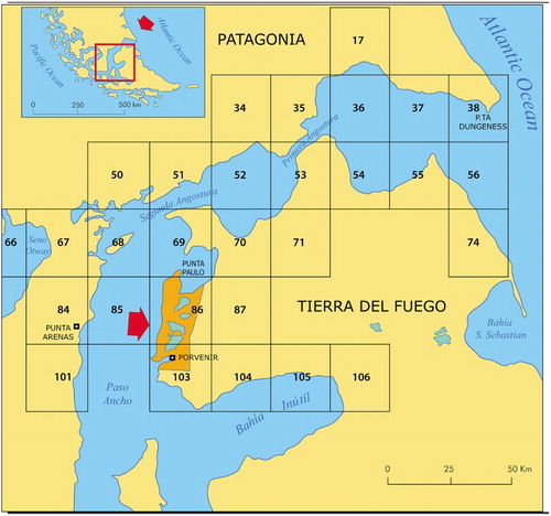
Figure 1. The orange area highlights the study area and map location. The black squares indicate the location of topographic maps published by the Chilean I.G.M. at a scale of 1:50,000. The geomorphological map published herein has a scale of 1:50,000 and falls within Sheets No. 86, 69 and 103 of Section L of the Chilean I.G.M. catography.
2. Regional settings
The study area is situated in the southernmost tip of Chile at the border with Argentina and is centred on the ‘Caletta Hobbs’ and ‘Porvenir’ Sheets of the Chilean Army Geographic Institute I.G.M. (Section L – No 86/530000-700730 and 103/531500-700730).
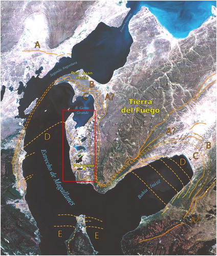
CitationMcCulloch, Fogwill, Sugden, Bentley, and Kubik (2005) published an integrated chronology of glacier fluctuations in the Strait of Magellan with specific reference to the study area () and suggest that the Last Glacial Maximum (LGM) began after 31,250 yrs BP and culminated approximately 25,200–23,100 yrs BP (stage B). The glacier retreated before 21,700–20,400 yrs BP, when a slightly less extensive advance (stage C) than the previous LGM occurred. A third major glacier advance was also found before 17,500–16,620 yrs BP (stage D) with evidence that glaciers continued to occupy the southern Strait for a further 1000 year. A detailed evolution of the flooding of the Strait of Magellan has been given by CitationBrambati (2000). As in other areas of Patagonia-Tierra del Fuego (CitationSchellmann & Radtke, 2010) the glacial evolution of the area has added to the contemporaneous and subsequent morphogenesis of a littoral and marine environment, which is particularly active in depressed areas due to glacio-isostasy.
Figure 2. Glacier fluctuations in the Strait of Magellan according to McCulloch, Fogwil et al. (2005, modified). The red rectangle indicates the location of the study area. Limits of glacial stages A, B, C, D and E are indicated in this figure.
The most commonly outcropping ground in the region between Punta Paulo and Porvenir consists of glacial deposits almost exclusively from the last glaciation (CitationClapperton, Sugden, Kaufman, & McCulloch, 1995). Probable exceptions are the deposits found on the relief of Altos de Boqueron representing an older glaciation. In the Porvenir-Paso Ancho area remains of the largest fronts of three glaciations can be recognised (CitationClapperton, 1992; CitationDarvill et al., 2016; CitationKaplan et al., 2008; CitationMcCulloch, Fogwil et al., 2005; ). CitationClapperton et al. (1995) indicate an age of 13,920, 14,990 and 17,710 years B.P. for the deposits in the neighbourhood of Porvenir associated with these glacier fronts. Large moraines were also identified in the study area by CitationBentley et al. (2005).
3. Methods
The geomorphological map compiled in this study was prepared using geological and geomorphological data acquired through field surveys of Holocene glacio-eustatic and marine deposits and landforms. Sedimentological and palaeontological samples were collected during field surveys in 1991, 1994, 1995 and 2003 as part of the Italian National Programme for Research in Antarctica (PNRA) and subprojects: ‘Late Quaternary Climatic Evolution of the Magellan-Fuegine area (southern South America)’ and ‘Seismostratigraphy and sedimentology of the Southern Chilean margin’. Several studies were carried out as part of these two projects; however, the latest phase of coastal research continued from previous geomorphological mapping of the coast of the Strait of Magellan and focused on the study of raised shorelines and terraces of marine and transitional origins formed during the most recent Post-Glacial Maximum. This research led to the publication of two geomorphological maps at a scale of 1:100,000 (CitationBrambati, Colizza, et al., 1993; CitationBrambati, De Muro, & Di Grande, 1993) and three geomorphological maps at a scale of 1:200,000 (CitationBrambati, De Muro, & Di Grande, 1995; CitationDe Muro, Di Grande, & Brambati, 1995, Citation1997; CitationDi Grande, De Muro, & Brambati, 1995). More detailed studies were also undertaken with cartographic production at a scale of 1:50,000 (CitationDe Muro, Di Grande, & Brambati, 1996a, Citation1996b, Citation1996c; CitationDe Muro, Di Grande, & Brambati, 2000; CitationDe Muro, Di Grande, Brambati, & Marini, 1997; CitationDe Muro, Di Grande, Fontolan, & Brambati, 2000; CitationDi Grande, De Muro, & Brambati, 1996a, Citation1996b; CitationDi Grande, De Muro, Brambati, & Marini, 1997). These studies represent the starting dataset for the development of the Geomorphological Atlas of the Coasts of the Straits of Magellan focused on the mapping of marine and transitional terraces. The Atlas consists of nine maps edited and printed for distribution as part of a dedicated booklet presented at the 32nd IGCC (CitationBrambati & De Muro, 2004; CitationDe Muro, Di Grande, & Brambati, 2004). Newer studies (De Muro et al., 2012; CitationDe Muro & Brambati, 2012) focused on the fossiliferous content of the identified coastal terraces formed within the complex transitional phases between the LGM and the subsequent Holocene marine ingression in the Straits. As part of this research, the mapping outputs changed from hard copy to digital cartography compiled at a detailed scale of 1:50,000 (CitationDe Muro et al., 2015), with further details added to the identification of coastal terraces and raised shorelines and data on present littoral dynamics.
The Main Map presented in this paper is the second cartographic outcome compiled as part of this latest digital mapping effort focused on the production of a detailed map at a scale of 1:50,000. This cartographic series allowed the visualisation of raised shorelines to be made continuously throughout the investigated region. It is part of a new surveying and mapping phase (CitationDe Muro, Ibba, & Kalb, 2016) which is testing the usage of new map keys (CitationDe Muro, Pusceddu, Buosi, & Ibba, 2017) applicable worldwide to a variety of environmental and managerial topics (CitationDe Muro, Porta, Passarella, & Ibba, 2017; CitationPennetta et al., 2016).
The Main Map presented in this paper includes terraces formed as a result of marine littoral sediment dynamics, and also terraces of mixed origin which were defined as transitional in CitationDe Muro et al. (2015). This map also focuses on raised shorelines providing important clues for the reconstruction of the Holocene palaeogeography of the study area. Transitional terrace successions have nearly flat erosion surfaces terminating with a step palaeo cliff at both ends. They were generated by processes ranging from glacial and lacustrine to clearly littoral (marine), typically related to glacial–interglacial phases (CitationDarvill et al., 2014; CitationLovell et al., 2011).
Outcrop field data corresponding to geological boundaries and geomorphological features were checked and interpreted using aerial photographs at an approximate scale of 1:60,000. Aerial photography was provided by the ‘Servicio Aerofotogrammetrico Fuerza Aerea de Chile’ (SAF). These analyses led to the generation of a preliminary geomorphological map using a 1:50,000 I.G.M. topographic map as a base layer.
The spatial distribution of marine terraces was subsequently surveyed in the field tracing by generating a topographic transect grid. Transects were oriented both perpendicular and parallel to the shoreline, with distance among consecutive transects dependent on beach and survey site access. Position accuracy was 25–50 m for horizontal distance and 2–3 m for vertical elevation and was achieved using both theodolite and a hand-held global positioning system (GPS) receiver.
The second draft of the map was completed in aerial photogrammetric laboratories, redrawing and refining the limits of the outcrops using an OMI stereo facet plotter (CitationPetrie, 1992). Data from field surveys and observation of aerial photography were incorporated to validate the final mapping outcome. The third and final mapping stages were the digitization of the geomorphological map, which was scanned and processed using Autodesk-Map-3D. The final digital map was created using Adobe Illustrator CS5.
4. Results
The following morphogenetic units can be outlined in the study area: (1) Altos de Boqueron ridge, in the easternmost zone, includes the highest area and is made up of glacial deposits. (2) Porvenir-Paso Ancho ridge, is characterized by drumlin fields and related lakes. (3) Terraced coastal belt and (4) Central peri-lacustrine belt. The overall geomorphology is mainly characterised by the presence of low relief (prevalently hills) and flat areas in both the coastal and peri-lacustrine regions.
According to CitationBenn and Clapperton (2000), the distribution and internal architecture of moraine belts such as the Porvenir-Paso Ancho ridge suggest that the formation of Bahia Gente Grande can be attributed to glacial morphogenesis as an effect of an eroding glacier front. The research carried out as part of this study confirms that the area is characterised by a high frequency of drumlins, at times eroded, rigorously NE–SW oriented, also outlined by CitationDarvill et al. (2016). Among the features associated with surface runoff, kettle hole-type forms are also present, also associated with drumlins and outlined by CitationBenn and Clapperton (2000).
Geomorphological and palaeogeographic data presented in this paper are in line with studies by CitationBenn and Clapperton (2000), CitationBentley et al. (2005), CitationClapperton (1992), CitationClapperton et al. (1995), CitationGlasser and Jansson (2008) and CitationMeglioli (1992) on the glacial environment of the Magellan area. These studies focus on glacial landforms and provide baseline information for mapping glacial geomorphological features. However, the most prominent features of the map presented herein are Holocene coastal terraces of marine and transitional origin. Raised shorelines are also common morpho-sedimentological features.
4.1. Marine and transitional features
Mainly Holocene raised shorelines, consisting of marine and transitional features, were identified in a large coastal area of the Straits of Magellan extending for ∼1000 km and including the study area. They are mainly represented by gravel, sand and silt deposits, or rarely only by simple erosion surfaces. In the majority of the analysed outcrops, terrace sequences start with an evident unconformity eroded in the till, with sandy gravel beach deposits rich in modern marine fauna at the top (CitationBrambati et al., 1998). The terrace succession contains mainly marine and littoral deposits and other complex sedimentary features of medium- and small-scale, such as beach ridges, sand bars, cuspate forelands and other marine littoral features.
Four main orders of terraced sequences were identified. The first and oldest terrace shows a regular distribution between 18 and 25 m above present sea level ( and ). Sand and silt deposits of a transitional depositional environment from glacio-lacustrine to marine prevail in this terrace. Because of its stratigraphic position and through radiocarbon dating presented in CitationDe Muro and Brambati (2012) and CitationDe Muro et al. (2015), the first-order terrace was attributed to the Early Holocene.
Figure 3. Locations of Figures 4–8.
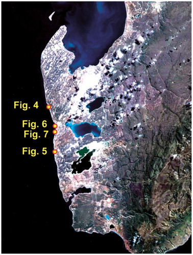
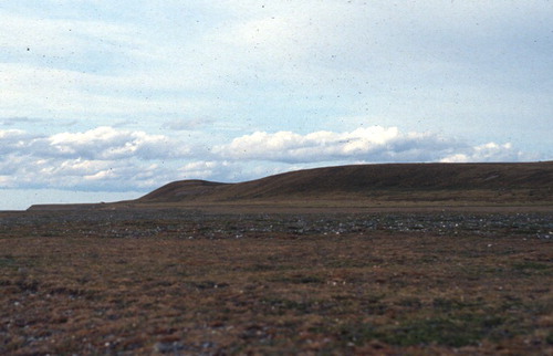
Figure 4. North of Porvenir: view of first-order terraces and relative palaeo cliffs.
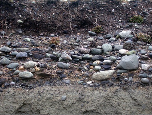
The second-order terrace is distributed between 6 and 11 m above present sea level, and is mainly represented by fossiliferous gravel deposits, sands and silts (, –). It regularly outcrops along the coast showing a large coastal extent, but is also visible in the main fluvial valley further inland. Complex sedimentary structures such as palaeo beach ridges and sand bars are occasionally observed within this terrace representing the remains of previous beach environments of the Magellan Straits. 14C data from CitationBrambati et al. (1998) suggest that this terrace formed between approximately 6000 and 7000 years B.P.
Figure 5. South of Punta Gente: view of second-order terraces and relative palaeo cliffs.
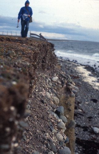
Figure 6. North of Porvenir: fossiliferous gravel of the second-order terrace overlying glacial sediments (till) and present beach environment.
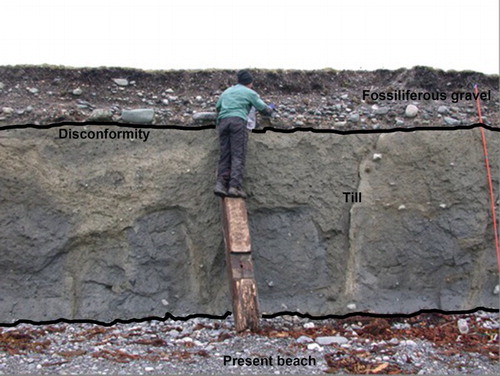
Figure 7. Detail of fossiliferous gravel of showing the transition to present soil.
The third-order terrace follows the morphology of the present beach environment at an elevation of 3–5 m above sea level, immediately below the second-order terrace. This terrace consists of fossiliferous gravels and sands of marine origin. 14C analysis of samples taken discontinuously along this landform provided ages between 4000 and 5000 years B.P. for the oldest marine deposits in the terrace. Dating of the upper part of the sequence showed ages up to 3000–2500 B.P (CitationBrambati et al., 1998; De Muro et al., 2012).
The fourth order terrace was identified at 1–2 m above mean-sea level and is discontinuous along the coastline.
4.2. Lacustrine features
The main lakes in the study area are elongated in the prevalent direction of drumlins and other glacial forms. According to CitationClapperton (1992), CitationMcCulloch, Bentley, Tipping, and Clapperton (2005) and CitationDarvill et al. (2016), these are glacial remnants related to various stages of the last glaciation. The central and northern lakes visible on the Main Map could represent marine ingression areas for the Late-Holocene post-glacial phase with subsequent deposition of terrace sequences. Present lacustrine depressions and surrounding terraces are found at elevations compatible with that of the second order of coastal terraces; however, the lack of marine invertebrates does not allow the correlation between lacustrine and coastal terraces to be made. For this reason, the area surrounding Laguna Verde is mapped with the same colour as the second-order terrace but is described as ‘uncertain attribution to marine/transitional environments’ in the Main Map legend.
4.3. Aeolian features
Wind activity is extremely intense and continuous along the entire coastal belt and the most evident effect is the leeward migration of lakes. The distribution of small lakes is strongly conditioned by glacial residual morphology, particularly drumlins. The lake’s water surface is exposed to wind blowing prevalently from west to east all year round, thus favouring lake and pond drift due to the deflation.
Small dunes are found along the coast especially in areas characterised by a large tidal range, such as Bahia Gente Grande (Main Map). In this region, wind erosion of fine beach sediment generates extensive lag deposits and dunes. The south-eastern quadrant of Bahia Gente Grande is characterised by west–east alternations of deflation surfaces and longitudinal dunes.
4.4. Features linked to surface runoff
Streams characterising the coastal belt show a discontinuous water flux, sometimes generating rills. At higher elevations and away from the coast, features most likely related to glaciation or receding outwash during glacial times dominate in the form of braided surfaces (meandering branches), associated with paleo-outwash channels. These features are clearly visible on satellite images of the central-eastern sector of the study area. These meandering torrents evolved to meandering systems in Holocene times and are occasionally fed by snow from Altos de Boqueron ridge. Flood plains are characterised by alluvial deposits that in the mouth area, according to a glacial interpretation, become outwash plains.
5. Conclusions
The geomorphological map presented in this paper provides an overview of the marine and transitional terraces occurring in the coastal belt between Punta Paulo and Porvenir. These features deposited following LGM in a chronological succession till present. Coastal terrace sequences are mostly developed above glacial features showing clear angular discordance and sharp erosive truncation. These features were produced by processes ranging from glacial and lacustrine to littoral (marine), typically related to glacial–interglacial phases (CitationBenn & Clapperton, 2000; CitationDarvill et al., 2014, Citation2016; CitationLovell et al., 2011, Citation2012; CitationMcCulloch & Davies, 2001).
The mapped terraces represent various stages of formation linked to the highest marine ingression following deglaciation in the eastern region of the Straits of Magellan. The first-order (18 and 25 m) terrace is highly eroded at present and is likely to have formed in the initial deglaciation phase (following stage E of CitationMcCulloch, Fogwil et al., 2005). The deposition of this terrace occurred in a transitional environment from glacio-lacustrine to marine, stratigraphically evolving to a tidal marine environment. The second-order terrace (6000–7000 years B.P.) was mapped between 6 and 11 m and is deemed to show the previous coastal morphology of the Magellan Straits. The third-order terrace (4000–5000 years B.P.) was found at elevations between 3 and 5 m and faithfully reproduces the present course of the Strait as evidence of a slow-down reaching eustatic equilibrium and renewed isostasy. The second, third and fourth (1–2 m above mean-sea level −2500–1200 years B.P.) order of coastal terraces and their raised shorelines, almost always contain marine fauna; all three are therefore of marine origin. Whilst the first-order terrace is linked to the transition from glacial withdrawal to the first marine ingression of the Holocene Sea, the remaining three terrace orders found a net marine dominance interrupted by several uplift events linked to glacial isostatic rebound.
The remaining geomorphological features mapped in the study area have lacustrine, aeolian and surface runoff origins. Whilst deglaciation processes resulted in the formation of several lacustrine (i.e. proglacial lakes) and surface runoff features (i.e. outwash plains) in the Porvenir region, intense wind activity is responsible for the formation of coastal sand dunes and deflation surfaces in the Bahia Gente Grande area.
Software
The map was produced manually on the basis of geomorphological and geological field surveys of Holocene deposits, with the support of aerial photographs and remote sensing interpretation. The map was drafted using Autodesk-Map-3D. Final map layout was performed using Adobe Illustrator CS5 TM.
Geomorphology of marine and transitional terraces and raised shorelines between Punta Paulo and Porvenir, Tierra del Fuego, Straits of Magellan – Chile.pdf
Download PDF (1.6 MB)Acknowledgements
We would like to thank Dr Ximena Prieto from the Università de Magallanes and Dr Gino Casassa Rogazinski from the Centro Austral Antartico di Punta Arenas (Chile).
I sincerely thank a dear friend, irreplaceable field companion and mentor Prof. Angelo Di Grande. He passed away when the maps were being finalised. His scientific contribution in this research was fundamental.
Disclosure statement
No potential conflict of interest was reported by the authors.
Additional information
Funding
Related Research Data
References
- Aguirre, M. L., Richiano, S., & Sirch, Y. N. (2006). Palaeoenvironments and palaeoclimates of the Quaternary molluscan faunas from the coastal area of Bahía Vera-Camarones (Chubut, Patagonia). Palaeogeography, Palaeoclimatology, Palaeoecology, 229(4), 251–286. doi:10.1016/j.palaeo.2005.06.025
- Andersson, G. J. (1906). Geological fragments from Tierra del Fuego. Geological Institution Upsala, 8, 169–183.
- Auer, V. (1974). The isorythmicity subsequent to the Fuego-Patagonian and Fennoscandian ocean level transgression of the latest glaciation. Annales Academiae Scientiarum Fennicae Series AIII, 115, 1–188.
- Bartole, R., Colizza, E., De Muro, S., & Colautti, W. (2000). The Pacific entrance of the Magellan Strait: Preliminary results of a seismic and sampling survey. Terra Antartica Reports 2000, 4, 81–94. ISSN: 1723-7211
- Bartole, R., Colizza, E., De Muro, S., Donda, F., Fontolan, G., Presti, M., … Zanolla, C. (2001). Morphological and sedimentological aspects of the South Chile Margin between 52° 30′ and 54° 30′ Lat. S. Terra Antarctica Reports 2001, 8(2), 99–110. ISSN: 1723-7211
- Bartole, R., De Muro, S., Morelli, D., & Tosoratti, F. (2008). Glacigenic features and Tertiary stratigraphy of the Magellan Strait (Southern Chile). Geologica Acta, 6(1), 85–100. doi:10.1344/105.000000243
- Benn, D. I., & Clapperton, C. M. (2000). Pleistocene glacitectonic landforms and sediments around central Magellan Strait, southernmost Chile: Evidence for fast outlet glaciers with cold-based margins. Quaternary Science Reviews, 19(6), 591–612. doi:10.1006/qres.2000.2140
- Bentley, M. J., & McCulloch, R. D. (2005). Impact of neotectonics on the record of glacier and sea level fluctuations, Strait of Magellan, southern Chile. Geografiska Annaler Series A – Physical Geography, 87A, 393–402.
- Bentley, M. J., Sugden, D. E., Hulton, N. R., & McCulloch, R. D. (2005). The landforms and pattern of deglaciation in the Strait of Magellan and Bahía Inútil, southernmost South America. Geografiska Annaler: Series A, Physical Geography, 87(2), 313–333.
- Brambati, A. (2000). Paleoclimatic and Paleoenvironmental records in sediments from the Southern Ocean (Straits of Magellan and Ross Sea). In A. Brambati (Ed.), Proceedings of the Workshop: Paleoclimatic reconstruction from marine sediments of the Ross Sea (Antarctica) and Southern Ocean (p. 267). Terra Antartica Reports 2000, 4, 1–41. ISSN: 1723-7211
- Brambati, A., Colizza, E., De Muro, S., Fontolan, G., Di Grande, A., & Simeoni, U. (1993, August 23–28). Geomorphological map of the coastal area of the Strait of Magellan between Punta Dungeness and Bahìa lnùtil (Chile) – Conference paper (p. 109). Paper Presented at the third international geomorphology conference, Hamilton, Canada.
- Brambati, A, & De Muro, S. (2004, 20–28 Agosto). The last marine ingression in central Magellan Straits, southernmost Chile: geological and geochemical evidences Vol. abstracts Part I, p. 354. Paper presented at the 32nd international geological congress, Florence, IT.
- Brambati, A., De Muro, S., & Di Grande, A. (1993, August 23–28). Geomorphological and textural map of the marine and coastal area of Bahìa Inùtil - Strait of Magellan - Chile 1:100.000 scale map (p. 109). Paper presented at the third international geomorphology conference, Hamilton, Canada.
- Brambati, A., De Muro, S., & Di Grande, A. (1995). Distribution of the marine and transitional terraces (Pleistocene?-Holocene) and geomorphological map of the coastal area between Bahı´a San Felipe and Paso Ancho – Straits of Magellan, Chile – 1:200.000 scale map (B). Trieste: Università degli Studi di Trieste – Dip. di Sc. Geologiche Ambientali e Marine.
- Brambati, A., De Muro, S., & Di Grande, A. (1998). Marine and transitional Holocene terraces in the eastern area of the Straits of Magellan, Chile. (+ three 1:200,000 scale maps). Bollettino di Geofisica Teorica e Applicata, 39, 47–76. ISSN: 0006-6729
- Brambati, A., Fontolan, G., & Simeoni, U. (1991). Carta sedimentologica dello Stretto di Magellano. Bolletino di Oceanologia Teoretica ed Applicata, Trieste, IX, 2–3.
- Bujalesky, G., Coronato, A., & Rabassa, J. (2004). Littoral evolution in the northern side of the Beagle Channel at Playa Larga, east of Ushuaia. In M. Menichetti, et al. (Eds.), “Field Trip guide of the Tierra del Fuego”. Geosur (Vol. 39, pp. 30–31). Buenos Aires.
- Bujalesky, G., & González Bonorino, G. (1990, November). Evidence for stable sea level in the late Holocene in San Sebastian Bay, Tierra del Fuego, southernmost Argentina. International Symposium of Quaternary Shorelines: Evolution, Processes and Future Changes (IGCP-274), La Plata, Vol. 9.
- Burns, K. L., Rickard, M. J., Belbin, L., & Chamalaun, F. (1980). Further palaeomagnetic confirmation of the Magellanes orocline. Tectonophysics, 63(1–4), 75–90.
- Clapperton, C. M. (1992). La ultima glaciacion y deglaciacion en el Estrecho de Magallanes: Implicaciones para el poblamiento de Tierra del Fuego. ANS. INS. PAT., Ser. C. Hs., Punta Arenas (Chile), 21, 113–128.
- Clapperton, C. M., Sugden, D. E., Kaufman, D. S., & McCulloch, R. D. (1995). The last glaciation in central Magellan Strait, southernmost Chile. Quaternary Research, 44(2), 133–148.
- Codignotto, J. O. (1984). Estratigrafía y geomorfología del Pleistoceno-Holoceno costanero entre los paralelos 53 30′ Sur y 42 00′ Sur, Argentina. In IX Congreso Geológico Argentino, San Carlos de Bariloche, Actas (Vol. 3, pp. 513–519).
- Cunningham, W. D., Klepeis, K. A., Gose, W. A., & Dalziel, I. W. (1991). The Patagonian Orocline: New paleomagnetic data from the Andean magmatic arc in Tierra del Fuego, Chile. Journal of Geophysical Research: Solid Earth, 96(B10), 16061–16067.
- Dalziel, I. W. D., Kligfield, R., Lowrie, W., & Opdyke, N. D. (1973). Paleomagnetic data from the southernmost Andes and the Antarctandes. Implications of Continental Drift to the Earth Sciences, 1, 87–101.
- Darvill, C. M., Stokes, C. R., Bentley, M. J., Evans, D. J. A., & Lovell, H. (2016). Dynamics of former ice lobes of the southernmost Patagonian Ice Sheet based on a glacial land systems approach. Journal of Quaternary Science. doi:10.1002/jqs.2890
- Darvill, C. M., Stokes C. R., Bentley M. J., & Lovell, H. (2014). A glacial geomorphological map of the southernmost ice lobes of Patagonia: The Bahía Inútil – San Sebastián, Magellan, Otway, Skyring and Río Gallegos lobes. Journal of Maps, 10(3), 500–520. doi:10.1080/17445647.2014.890134
- De Muro, S., & Brambati, A. (2012, 5–10 August). Atlas of the marine and transitional Holocene terraces – Eastern Straits of the Magellan Coasts – Patagonia and Tierra del Fuego (Chile) – 2012 edition (p. 354). Paper presented at the 34th international geological congress, Brisbane, Australia.
- De Muro, S., Di Grande, A., & Brambati, A. (1995). Distribution of the marine and transitional terraces (Pleistocene–Holocene) and geomorphological map of the coastal area between Punta Dungeness and Bahìa San Felipe – Straits of Magellan, Chile – 1:200.000 scale map (A). Trieste: Università degli Studi di Trieste – Dip. di Sc. Geologiche Ambientali e Marine.
- De Muro, S., Di Grande, A., & Brambati, A. (1996a, 21–25 maggio). Distribution of the marine and transitional terraces (Holocene) and geomorphological map of the coastal area between Punta Paulo and Porvenir – Tierra del Fuego, Straits of Magellan – Chile (1:50,000 scale map) Map 3/12. Paper presented at the XXVII Italian Geographic Conference, Trieste, IT.
- De Muro, S., Di Grande, A., & Brambati, A. (1996b). Distribution of the Marine and transitional terraces (Holocene) and geomorphological map of the coastal area of Península Juan Mazía, Tierra del Fuego – Straits of Magellan – Chile (1:50,000 scale map) Map 2/12. Alpine and Mediterranean Quaternary, 9(1).
- De Muro, S., Di Grande, A., & Brambati, A. (1996c). Holocene evolution and geomorphological features of the coast of the Juan Mazia Peninsula (Sheets “Puerto Percy”, “Bahia Felipe” and “Puerto Sara”) (Tierra del Fuego, Magellano Strait, Chile). Alpine and Mediterranean Quaternary, 9(1), 405–411.
- De Muro, S., Di Grande, A., & Brambati, A. (1997). Distribution of the marine and transitional Terraces (Holocene) and geomorphological map of the Punta Catalina, Tierra del Fuego – Straits of Magellan – Chile. Suppl. Geografia Fisica E Dinamica Quaternaria, 3(1), 139.
- De Muro, S., Di Grande, A., & Brambati, A. (2000). Holocene evolution of the Primera angostura based on map 5/12 of the geomorphological atlas of the Strait Of Magellan (Southern Chile). (+1:50.000 scale map). Terra Antartica Reports, 4, 43–54.
- De Muro, S., Di Grande, A., & Brambati, A. (2004, August 20–28). Atlas of the marine and transitional terraces in the Magellan Straits – Patagonia and Tierra del Fuego, Vol. abstracts Part I, p. 353. Paper presented at the 32nd international geological congress, 2004, Florence, IT.
- De Muro, S., Di Grande, A., Brambati, A., & Ibba, A. (2015). Geomorphology map of the marine and transitional terraces and raised shorelines of the Península Juan Mazía, Tierra Del Fuego. Straits of Magellan–Chile. Journal of Maps, 11(5), 698–710. doi:10.1080/17445647.2014.970592
- De Muro S., Kalb C., Brambilla W., & Ibba A. (2012). Sedimentological, geomorphological and geochemical evidence of the last marine ingression in central Magellan Straits-southernmost Chile. Rend. Online Soc. Geol. It., 20, 33–34.
- De Muro, S., Di Grande, A., Brambati, A., & Marini, A. (1997). The Punta Catalina area in post-glacial Magellanic evolution Map N 4/12 of the Geomorphological Atlas of the Coasts of the Strait of Magellan (Tierra del Fuego – Chile). Conference paper including 1:50.000 Scale Map: De Muro S., Kalb C., Brambilla W., & Ibba A. (2012). Sedimentological, geomorphological and geochemical evidence of the last marine ingression in central Magellan Straits-southernmost Chile. Rend. Online Soc. Geol. It., 20, pp. 33–34.
- De Muro, S., Di Grande, A., Fontolan, G., & Brambati, A. (2000). The area of Punta Catalina in the Magellanic Postglacial evolutionary framework. Map N. 4/12 of the Geomorphological Atlas of the Coasts of the Strait of Magellan. Terra Antartica Reports 2000, 4, 55–62. ISSN: 1723-7211.
- De Muro, S., Ibba A., & Kalb, C. (2016). Morpho-sedimentology of a Mediterranean microtidal embayed wave dominated beach system and related inner shelf with Posidonia oceanica meadows: The SE Sardinian coast. Journal of Maps, 12(3), 558–572. doi:10.1080/17445647.2015.1051599
- De Muro, S., Porta, M., Passarella, M., & Ibba, A. (2017). Geomorphology of four wave-dominated microtidal Mediterranean beach systems with Posidonia oceanica meadow: A case study of the Northern Sardinia coast. Journal of Maps, 13(2), 74–85. doi:10.1080/17445647.2016.1250681
- De Muro, S., Pusceddu, N., Buosi, C., & Ibba, A. (2017). Morphodinamics of a Mediterranean microtidal wave-dominated beach: Forms, processes and insights for coastal management. Journal of Maps, 13(2), 26–36. doi:10.1080/17445647.2016.1259593
- Di Grande, A., De Muro, S., & Brambati, A. (1995). Distribution of the marine and transitional terraces (Pleistocene–Holocene) and geomorphological map of the coastal area between Porvenir and Puerto Yartoù – Straits of Magellan, Chile – 1:200.000 scale map (C). Trieste: Università degli Studi di Trieste – Dip. di Sc. Geologiche Ambientali e Marine.
- Di Grande, A., De Muro, S., & Brambati, A. (1996a). Distribution of the marine and transitional terraces (Holocene) and geomorphological map of the coastal area between Seno Otway and Bahia Shoal, Patagonia – Straits of Magellan – Chile (1:50,000 scale map) Map 1/12. Alpine and Mediterranean Quaternary, 9(1). ISSN: 0394-3356
- Di Grande, A., De Muro, S., & Brambati, A. (1996b). The Quaternary along the coast of the Brunswick Peninsula in the Villa Kon Aiken” and “Isia Isabel” Sheets (Magellano Strait, Chile). Alpine and Mediterranean Quaternary, 9(1), 399–404.
- Di Grande, A., De Muro, S., Brambati, A., & Marini, A. (1997). Holocenic evolution of the Primera Angostura based on a 1:50,000 scale map (S. 5/12) of the Geomorphological Atlas of the Coasts of the Strait of Magellan – southern Chile. Conference paper including 1:50,000 scale map: De Muro S., Di Grande A, Brambati A. (1997). Distribution of the marine and transitional Terraces (Holocene) and geomorphological map of the Primera Angostura, Patagonia -Tierra del Fuego – Straits of Magellan – Chile. Suppl. Geografia Fisica E Dinamica Quaternaria, III(1), 146. ISSN: 0391-9838
- Feruglio, E. (1933). I terrazzi marini della Patagonia. Giornale Di Geologia, 7, 1–288.
- Glasser, N., & Jansson, K. (2008). The glacial map of southern South America. Journal of Maps, 4, 175–196.
- Gordillo, S., Coronato, A., & Rabassa, J. (1990). Paleoecology and geomorphological evolution of a fjord during the Late-Glacial and the Early Middle Holocene of Tierra del Fuego. In Bujalesky, G. G. (Ed.), Field Guide - The Quaternary of Tierra del Fuego (Argentina), IGCP-274, 23–30. Edited by F.I. Isla. Published by Provincia de Buenos Aires/Comision de Investigaciones Cientificas CIC.
- Halle, T. (1910). On Quaternary deposits and changes of level in Patagonia and Tierra del Fuego. Bulletin of the Geological Institution of the University of Uppsala, 9(17/18), 93–117.
- Isla, F. I., & Bujalesky, G. G. (2008). Coastal geology and morphology of Patagonia and the Fuegian Archipelago. In J. Rabassa (Ed.), The Late Cenozoic of Patagonia and Tierra del Fuego: Developments in quaternary sciences (Vol. 11(C), pp. 227–239). Ushuaia: CADIC-CONICET, Universidad Nacional del la Patagonia.
- Kaplan, M. R., Fogwill, C. J., Sugden, D. E, Hulton, N., Kubik, P. W., & Freeman, S. (2008). Southern Patagonian glacial chronology for the Last Glacial period and implications for Southern Ocean climate. Quaternary Science Reviews, 27, 284–294.
- Lodolo, E., Menichetti, M., Bartole, R., Ben-Avraham, Z., Tassone, A., & Lippai, H. (2003). Magallanes - Fagnano continental transform fault [Tierra del Fuego, southernmost South America]. Tectonics, 22(6), 1076. doi:10.1029/2003TC0901500
- Lodolo, E., Menichetti, M., Tassone, A., & Sterzai, P. (2002). Morphostructure of the central-eastern Tierra del Fuego Island from geological data and remote-sensing images. EGS Stephan Mueller Special Publication Series, 2(1), 1–16.
- Lovell, H., Stokes, C. R., & Bentley, M. J. (2011). A glacial geomorphological map of the Seno Skyring-Seno Otway-Strait of Magellan region, southernmost Patagonia. Journal of Maps, 7(1), 318–339. doi:10.4113/jom.2011.1156
- Lovell, H., Stokes, C. R., Bentley, M. J., & Benn, D. I. (2012). Evidence for rapid ice flow and proglacial lake evolution around the central Strait of Magellan region, southernmost Patagonia. Journal of Quaternary Science, 27, 625–638.
- Markgraf, V. (1980). New data on the late and Postgalcial Vegetational History of La Mission, Tierra Del Fuego, Argentina. Proceedings IV International Palynological Conference (Vol. 3, pp. 68–74), Lucknow, India.
- McCulloch, R. D., Bentley, M. J., Tipping, R. M., & Clapperton, C. M. (2005). Evidence for late-glacial ice dammed lakes in the central Strait of Magellan and Bahia Inútil, southernmost south America. Geografiska Annaler: Series A, Physical Geography, 87(2), 335–362.
- McCulloch, R. D., & Davies, S. J. (2001). Late-glacial and Holocene palaeoenvironmental change in the central Strait of Magellan, Southern Patagonia. Palaeogeography, Palaeoclimatology, Palaeoecology, 173(3), 143–173. doi:10.1016/S0031-0182(01)00316-9
- McCulloch, R. D., Fogwill, C. J., Sugden, D. E., Bentley, M. J., & Kubik, P. W. (2005). Chronology of the last glaciation in central Strait of Magellan and Bahía Inútil, southernmost South America. Geografiska Annaler: Series A, Physical Geography, 87(2), 289–312.
- Meglioli, A. (1992). Glacial geology of southernmost Patagonia, the Strait of Magellan and northern Tierra del Fuego (Unpublished PhD thesis). Lehigh University, Bethlehem, Pennsylvania, USA.
- Menichetti, M., Lodolo, E., & Tassone, A. (2008). Structural geology of the Fuegian Andes and Magallanes fold-and-thrust belt-Tierra del Fuego Island. Geologica Acta, 6(1), 19–42.
- Mörner, N. (1987). Sea level changes and tectonics in Tierra del Fuego. Bulletin of the International Union for Quaternary Research Neotectonics Commission, 10, 31.
- Pennetta, M., Brancato, V. M., De Muro, S., Gioia, D., Kalb, C., Stanislao, C., … Donadio, C. (2016). Morpho-sedimentary features and sediment transport model of the submerged beach of the ‘Pineta della foce del Garigliano’ SCI Site (Caserta, southern Italy). Journal of Maps, 12(1), 139–146. doi:10.1080/17445647.2016.1171804
- Petrie, G. (1992). Trends in analytical strumentation. ITC Journal, 4, 364–383.
- Porter, S. C., Clapperton, C. M., Sudgen, D. E. (1992). Chronology and dynamics of deglaciation along and near the Strait of Magellan, southernmost South America. Sveriges Geologiska Undersøkning, Series Ca., 81, 233–239.
- Porter, S. C., Stuiver, M., & Heusser, C. J. (1984). Holocene sea-level changes along the Strait of Magellan and Beagle Channel, southernmost South America. Quaternary Research, 22(1), 59–67.
- Rabassa, J., Bujalesky, G. G., Meglioli, A., Coronato, A., Gordillo, S., Roig, C., … Salemme, M. (1992). The Quaternary of Tierra del Fuego, Argentina: The status of our knowledge. Sveriges Geologiska Undersøkning, Series Ca., 81, 249–256.
- Rabassa, J., Serrat, D., Marti, C., & Coronato, A. (1988). Estructura interna de drumlins, Isla Gable, Canal Beagle, Tierra del Fuego. Segunda ReunioHn Argentina de SedimentologmHa, 222–226.
- Rostami, K., Peltier, W. R., & Mangini, A. (2000). Quaternary marine terraces, sea-level changes and uplift history of Patagonia, Argentina: Comparisons with predictions of the ICE-4G (VM2) model of the global process of glacial isostatic adjustment. Quaternary Science Reviews, 19(14), 1495–1525. doi:10.1016/S0277-3791(00)00075-5
- Schellmann, G., & Radtke, U. (2003). Coastal terraces and Holocene sea-level changes along the Patagonian Atlantic coast. Journal of Coastal Research, 19(4), 983–996.
- Schellmann, G., & Radtke, U. (2010). Timing and magnitude of Holocene sea-level changes along the middle and south Patagonian Atlantic coast derived from beach ridge systems, littoral terraces and valley-mouth terraces. Earth-Science Reviews, 103(1), 1–30. doi:10.1016/j.earscirev.2010.06.003
- Urien, C. M. (1966). Edad de algunas playas elevadas en la Península Ushuaia y su relación con el ascenso costero post-glaciario. Actas III Jornadas Geológicas Argentinas, 2, 35–42.
- Winslow, M., & Prieto, X. (1991). Evidence of active tectonics along the Strait of Magellan, Chile. In Congr. Geol. Chil. Resum. Expand (Vol. 6, pp. 654–655). Chile: Viña del Mar.