
ABSTRACT
A geological map is an indispensable tool for understanding the structure of the Earth’s crust but high-quality geological maps are usually lacking in remote areas of mountainous Central Asia covered by vast deserts. The progress in remote sensing and geographical information system (GIS), as well as the advancement in analytical methods, have generated new challenges in producing modern geological maps in such regions. The presented 1:50,000 geological map along the Sagsai River summarizes new and more accurate geological data from the geologically interesting region at the contact of the supracrustal and deep crustal Tugrug and Tseel units forming the metamorphosed accretionary wedge on the S and SW slopes of the Mongolian Altai. These geological units are formed by the lower Palaeozoic volcano-sedimentary sequences affected by Devonian Barrovian metamorphism ranging from lower greenschist to granulite facies. This metamorphic basement was subsequently intruded by the post-orogenic late Carboniferous Sagsai Pluton. The presented map shows complex relationships between different crustal levels of the metamorphosed accretionary wedge and post-tectonic intrusion evaluated using a GIS, numerical processing of remote sensing data as well as field documentation and laboratory studies.
1. Introduction
A geological map is a scaled-down interpretation of the structure of a selected area of the upermost layer of the Earth’s crust, usually drawn on a topographic base. Geological maps can be used solely for academic purposes but are also essential for economic development of individual countries. This is true in Central Asia, and especially in Mongolia, where the economy is based on mining and raw material exploration.
By 2003, Mongolia has been covered by geological maps at a scale of 1:200,000, while geological mapping at the scale 1:50,000 has been under way since 1990s. Even though there are available geological maps produced by foreign geological surveys (e.g. Japan, France, South Korea and the Czech Republic) only 40% of Mongolian territory is covered by maps at this scale and the maps are of variable quality.
As southern Mongolia is poorly covered by vegetation, modern geographical information system (GIS) methods combining the interpretation of remote sensing data with field reconnaissance and up-to-date analytical data represent an effective approach for the compilation of new geological maps. We present here an example of such geological map (map sheet No. L-47-85-G), which covers the drainage area of the Sagsai River between the Tseel and Tsogt districts in the SE Mongolian Altai. This Main Map demonstrates the efficiency of combined satellite imagery and field investigations in producing reliable low-cost geological maps in regions of high economic interest.
2. Map construction
The topographic base of the map was derived from ASTER GDEM V2 data with a resolution of 30 m. The shaded relief was prepared using the 3D Analyst tool of ArcGIS in 4 layers with azimuths of 60°, 150°, 20° and 330° and a constant Sun angle of 30°. The course of the rivers was digitized from Landsat 8 imagery and roads were outlined using a global positioning system (GPS) receiver. Contour lines with 25 m interval were generated using the Contour tool in ArcGIS based on ASTER GDEM V2 data. False contours and apparent mistakes were manually deleted and the remaining contours digitally smoothed.
Geological boundaries were interpreted from the Landsat 8 scenes p137-138r28-29. These satellite images, free of cloud cover for the year 2015, were downloaded from the USGS website and processed using image enhancement techniques with GRASS GIS and Python. Principal component analysis and factor loading analysis with an emphasis on geological information showed that band combinations (6, 7, 4) had the highest contrast that could be further enhanced with a decorrelation stretch. Band ratio combinations (4/3, 6/2, 7/4) had good contrast for geological information and formed the input data for visual classification.
The geological interpretation of Landsat 8 imageries was supported by field documentation on 212 reference points complemented by nearly 60 thin sections and 21 whole-rock geochemical analyses.
Lithostratigraphic columns were constructed according to the observed field relationships. The chronological assignment of geological events was done according the published data cited in the text and supplemented by unpublished radiometric data of the Czech Geological Survey.
3. Geology
3.1. Regional setting
The studied section lies in the Mongolian part of the large accretionary Phanerozoic system covering the whole of central Asia and called the Central Asian Orogenic Belt (CAOB of CitationMossakovsky, Ruzhentsev, Samygin, & Kheraskova, 1994; CitationWindley, Alexeiev, Xiao, Kröner, & Badarch, 2007). This area is located south of the Main Mongolian Lineament (), which represents the main tectonic boundary separating the Neoproterozoic domain in the north, affected by early Palaeozoic orogenic event, from the early Palaeozoic domain to the south (e.g. CitationBadarch, Cunningham, & Windley, 2002; CitationKröner et al., 2010; CitationRuzhentsev & Pospelov, 1992) affected by late Devonian to late Palaeozoic deformation and metamorphism (CitationEdel, Schulmann, Hanžl, & Lexa, 2014; CitationLehmann et al., 2010; CitationXiao et al., 2009).
Figure 1. Simplified geological sketch of SW Mongolia with the location of the studied area. Inset shows the position of the CAOB within the framework of adjacent geological units. Modified from CitationBadarch et al. (2002), CitationKröner et al. (2010), CitationGuy et al. (2014) and CitationHanžl et al. (2016). MML, Main Mongolian Lineament.
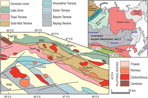
Main Map (map sheet No. L-47-85-G) covers the boundary between the volcano-sedimentary sequences of the Gobi Altai Terrane and metamorphic rocks of the Tseel Terrane () according to regional nomenclature of CitationBadarch et al. (2002). The boundary between these units is lithological in the West and East, and sealed in the South by intrusion of the late Carboniferous mafic Sagsai Pluton (CitationBuriánek et al., 2016). Recent study by CitationHanžl et al. (2016) suggests that these two units represent varying degrees of metamorphism of an early Palaeozoic accretionary wedge.
3.2. Tseel Terrane
The Tseel Terrane (CitationBibikova et al., 1992) forms an E–W trending narrow belt along the southern slopes of the Mongolian Altai. It is composed of lower Palaeozoic volcano-sedimentary rocks with Devonian to late Carboniferous polymetamorphic history (e.g. CitationBurenjargal et al., 2014; CitationJiang et al., 2012; CitationKozakov et al., 2007) intruded by the Devonian to Triassic plutons (CitationBurenjargal et al., 2016; CitationBuriánek et al., 2016; CitationCai et al., 2015). Two parts of the Tseel Terrane are exposed on the map: the Tseel Metamorphic Complex in the SW and the Tsogt Metamorphic Complex in the SE.
3.2.1. Tseel Metamorphic Complex
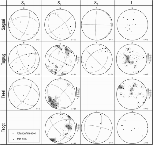
The Tseel Metamorphic Complex is composed of phyllites to garnet-bearing micaschists which alternate with layers of metarhyolites and greenschists to amphibolites, and two orthogneiss belts of Devonian protolith age (CitationHanžl et al., 2016). The southern orthogneiss belt is formed by lithologically homogeneous coarse-grained orthogneiss, while the northern one consists of fine- to medium-grained orthogneisses containing layers of micaschists and amphibolites. Dominant structure is a NW–SE trending metamorphic foliation (S1) steeply dipping to the NE (). Two generations of folds and lineations are preserved; the earlier linear elements are steeply plunging to the N, while the younger ones are sub-horizontal and trending NW–SE.
Figure 2. Orientation diagrams of the selected structures in the geological formations along the Sagsai River. Planes plotted as poles, lower hemisphere, Schmidt projection, step of contours 2 sigma.
3.2.2. Tsogt Metamorphic Complex
The Tsogt Metamorphic Complex is characterized by the presence of high-grade metamorphic rocks represented by amphibole-biotite migmatites, migmatitized amphibolites and layered metagabbros. These rocks contain lenses of orthopyroxene granulite yielding a peak metamorphic age of 384±2 Ma (CitationKozakov, Glebovitsky, Bibikova, Azimov, & Kirnozova, 2002). The metamorphic sequence is intruded by foliation-parallel sheets of deformed granite and tonalite. The main metamorphic fabric S1 defines a dome-like structure as shown by poles of foliation concentrated along a NNE–SSW trending girdle in the stereonet ().
3.3. Gobi Altai Terrane
3.3.1. Tugrug Formation
In the study area, the Gobi Altai Terrane is represented by the Tugrug Formation, which was defined by CitationMarkova (1975) on the southern slopes of the Mongolian Altai. In the northern part of the region, the Tugrug Formation is formed by slates to sericite-chlorite phyllites with carbonaceous admixture and layers of tuffitic sandstones. Towards the south prevail epidote-chlorite greenschists alternating with tuffitic sandstone layers with locally preserved flattened pillow lavas. The southernmost part of the Sagsai River section is characterized by metagreywackes and metasiltstones.
Volcanic rocks of the Tugrug Formation are represented by subalkaline series forming a basalt – basaltic andesite – dacite – rhyolite compositional trend (). The Silurian stratigraphic age of the Tugrug Formation was assumed by analogy to similar sequences in the Shine-Jinst district to the east (CitationMarkova, 1975). However, Cambro–Ordovician age was proposed for this slightly metamorphosed volcano-sedimentary sequence in the geological maps of CitationBorzakovskii (1985) and CitationRauzer et al. (1987). As there are no palaeontological data from the study area we assume Cambrian to Ordovician age for the Tugrug Formation based on detrital zircon age spectra from the paragneisses of the Mongolian Altai further west (CitationJiang et al., 2012) and the lithologically identical Habahe Group rocks from the Chinese Altai (CitationJiang et al., 2011). This proposition is further supported by the unpublished clastic zircon U–Pb age spectra from two samples collected from the Tugrug Formation north of Tsogt village. The youngest peaks at 506 and 475 Ma are interpreted to reflect the sedimentation of the Tugrug Formation volcano-sedimentary detritus (Y. Jiang, pers. communication).
Figure 3. Classification of volcanic rocks documented in the map area in Nb/Y vs. Zr/Ti diagram (CitationPearce, 1996). Unpublished data of the Czech Geological Survey.
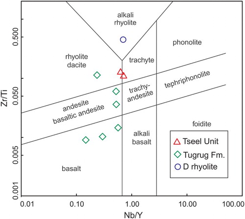
The volcano-sedimentary rocks of the Tugrug Formation in the Sagsai River valley are cross-cut by a dacite dyke, which yields a U–Pb zircon age of 380 Ma (LA ICP-MS – unpublished data on zircon of the Czech Geological Survey). A similar Devonian age (∼380 Ma) was reported for the slightly deformed rhyolite body NE of the Sagsai Pluton intruding the Tugrug Formation (Y. Jiang, pers. communication). Both dykes and rhyolites are chronologically and geochemically identical to syn-tectonic felsic orthogneisses of the structurally deeper Tseel Metamorphic Complex implying genetic link between these magmatic rocks (CitationHanžl et al., 2016).
The regional metamorphic grade of the Tugrug Formation increases to the SW where metagreywackes gradually pass into garnet-biotite schists at the boundary with the underlying Tseel complex. The boundary between the Tseel Metamorphic Complex and the Tugrug Formation is thus arbitrary and may be defined by lithological differences and metamorphic grade. In the present map it is placed between the variegated staurolite bearing schists and orthogneisses of the Tseel Metamorphic Complex and greenschist-facies metagreywackes of the Tugrug Formation W of the Sagsai Pluton. In contrast, the NE–SW trending boundary of the low-grade Tugrug Formation with the underlying high-grade Tsogt Metamorphic Complex is defined by the sharp metamorphic and lithological gradient.
Approaching the Sagsai Pluton, the low-grade greywackes and shales are transformed into biotite-chlorite and cordierite-biotite schists indicating increasing thermal metamorphic effects of the pluton. Septa inside the pluton are metamorphosed to cordierite-biotite schists and garnet-bearing sillimanite-biotite migmatitized paragneisses.
The Tugrug Formation rocks reveal well preserved bedding (S0) of variable orientation (). The bedding is transposed in many places to composite S1 foliation trending dominantly WNW–ESE. This pervasive fabric is refolded by open to closed, upright folds with steep NW–SE trending axial planar cleavage (S2).
3.3.2. Zalaa-Oroin Formation
Lower Carboniferous turbidites with prevailing siltstones of the Zalaa-Oroin Formation (CitationBezzubtsev, Zaporotets, & Lysov, 1959) unconformably cover paragneisses and schists at the NW corner of the Main Map. Carboniferous greywackes and sandstones are unmetamorphosed to weakly metamorphosed. The S0 bedding is folded by open upright NW–SE F2 folds and locally reworked by pronounced fracture to slaty S2 cleavage.
3.3.3. Sagsai Pluton
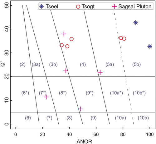
The Sagsai Pluton intruded the southern part of the Tugrug Formation at its contact with the Tseel Terrane. The body consists of monzogabbros to quartz diorites and biotite to amphibole-biotite syenites to quartz monzonites (). Mafic rocks with common mingling textures were intruded by dykes of two-mica granites arranged in a ring like structure along the rim of the pluton. U–Pb zircon dating of monzonite yielded ages of 307±2 and 309±2 Ma, while the gabbro revealed an older age of 322±2 Ma (CitationBuriánek et al., 2016).
Figure 4. Classification of plutonic rocks of the Sagsai Pluton, orthogneisses and metagranites of the Tseel and Tsogt metamorphic complexes in the Q’–ANOR diagram (CitationStreckeisen & Le Maitre, 1979) based on the Improved Granite Mesonorm (CitationMielke & Winkler, 1979): 2, alkali feldspar granite; 3, granite; 4, granodiorite; 5, tonalite; 6*, quartz alkali feldspar syenite; 7*, quartz syenite; 8*, quartz monzonite; 9*, quartz monzodiorite/quartz monzogabbro; 10*, quartz diorite/quartz gabbro; 6, alkali feldspar syenite; 7, syenite; 8, monzonite; 9, monzodiorite/monzogabbro and 10, diorite/gabbro. Based on CitationBuriánek et al. (2016), CitationHanžl et al. (2016) and unpublished data of the Czech Geological Survey.
Orientation of primary magmatic layering is scattered all around the pluton and is clearly discordant to NE–SW trending steep S1 and S2 foliations inside and outside the metamorphic aureole.
3.4. Cenozoic cover
The area has a denuded nature with insignificant Cenozoic cover. Recent fluvial sediments have evolved in the valley of the Sagsai River and its tributaries with intermittent streams. They are composed of gravels and sandy gravels with clasts up to 50 cm in size and also of blocks occurring close to the nearby slopes. Colluvial sediments are of minor areal extent. They are usually characteristic of debris fans under steeper slopes or silty deposits in flat depressions. Two small gold placers were found in these sediments and weathered rocks of the Tugrug Formation in the NW quadrant of the map. Sandy to silty aeolian deposits were only seen in one dune below the western rocky slope of the lower part of the Sagsai River valley.
4. Conclusions
The presented geological map sheet No. L-47-85-G summarizes recent Landsat 8 imagery, geological field and analytical data from the region at the southern slopes of the Mongolian Altai. In comparison with previous geological maps it shows a:
more precise subdivision of lithological and litho-stratigraphic units;
chronostratigraphic calibration of the main litho-stratigraphic units;
increase of the metamorphic grade in the Tugrug Formation from NE to SW towards the contact with the Tseel Metamorphic Complex;
similar pattern of regional metamorphic foliation trends of all units forming the Tseel and Gobi Altai terranes;
efficiency of using free Landsat imagery in combination with precise field lithological and structural data as well as modern geochronological and whole-rock geochemical data.
Software
The geological map was constructed using ArcGIS 10.2.1 and improved in Adobe Illustrator CS 11. Landsat 8 data were processed using Grass GIS and Python. The geochemical data were interpreted using the freeware GCDkit (CitationJanoušek, Farrow, & Erban, 2006) and structural data by the SpheriStat software.
Geology of the Gobi Altai and Tseel Terranes in the Central Part of the Sagsai River Watershed, SE Mongolian Altai.pdf
Download PDF (10.6 MB)Acknowledgments
We are thankful to M. Batsaikhan for logistic support of the expedition, T. Ganchuluun and A. Shagdarsuren for technical help in the field and Mongolian drivers for secure driving on poorly accessible roads. The authors wish to thank Wenjiao Xiao and Jérémie Lehmann for a critical review of the manuscript. We are also grateful to E. Kunceová for help with graphical polishing of the map.
Disclosure statement
No potential conflict of interest was reported by the authors.
ORCID
Pavel Hanžl http://orcid.org/0000-0002-9626-8508
Additional information
Funding
Related Research Data
References
- Badarch, G., Cunningham, W. D., & Windley, B. F. (2002). A new terrane subdivision for Mongolia: Implications for the Phanerozoic crustal growth of Central Asia. Journal of Asian Earth Sciences, 21(1), 87–110. doi:10.1016/S1367-9120(02)00017-2
- Bezzubtsev, V. V., Zaporotets, V. A., & Lysov, V. I. (1959). Geological mapping of the southeast Mongolian Altai and the soutwestern part Khangai at a scale of 1: 1,000,000. Moscow, Manuscript. (in Russian).
- Bibikova, E. V., Kirnozova, T. I., Kozakov, I. K., Kotov, A. B., Neymark, L. A., & Gorokhovskiy, B. M. (1992). U–Pb ages for polymetamorphic complexes on the southern flank of the Mongolian and Gobi Altai. Geotectonics, 26(2), 166–172.
- Borzakovskii, Y. A. (1985). Compilation of geological map and map of the ore deposits of the Western Mongolia (west of meridian 102°) at a scale of 1 : 500,000 with explanation text, 1st stage, compilation of map sheets M-46B, G; L-47A, B, V, G. Moscow, Zarubezgeologiia. Manuscript. (in Russian).
- Burenjargal, U., Okamoto, A., Kuwatani, T., Sakata, S., Hirata, T., & Tsuchiya, N. (2014). Thermal evolution of the Tseel Terrane, SW Mongolia and its relation to granitoid intrusions in the Central Asian Orogenic Belt. Journal of Metamorphic Geology, 32(7), 765–790. doi:10.1111/jmg.12090
- Burenjargal, U., Okamoto, A., Tsuchiya, N., Uno, M., Horie, K., & Hokada, T. (2016). Contrasting geochemical signatures of Devonian and Permian granitoids from the Tseel Terrane, SW Mongolia. Journal of Geosciences, 61(1), 51–66. doi:10.3190/jgeosci.210
- Buriánek, D., Janoušek, V., Hanžl, P., Jiang, Y., Schulmann, K., Lexa, O., & Altanbaatar, B. (2016). Petrogenesis of the Late Carboniferous Sagsai Pluton in the SE Mongolian Altai. Journal of Geosciences, 61(1), 67–92. doi:10.3190/jgeosci.207
- Cai, K., Sun, M., Jahn, B. M., Xiao, W., Yuan, C., Long, X., … Tumurkhuu, D. (2015). A synthesis of zircon U–Pb ages and Hf isotopic compositions of granitoids from southwest Mongolia: Implications for crustal nature and tectonic evolution of the Altai Superterrane. Lithos, 232, 131–142. doi:10.1016/j.lithos.2015.06.014
- Edel, J. B., Schulmann, K., Hanžl, P., & Lexa, O. (2014). Palaeomagnetic and structural constraints on 90° anticlockwise rotation in SW Mongolia during the Permo–Triassic: Implications for Altaid oroclinal bending. Preliminary palaeomagnetic results. Journal of Asian Earth Sciences, 94, 157–171. doi:10.1016/j.jseaes.2014.07.039
- Guy, A., Schulmann, K., Clauer, N., Hasalová, P., Seltmann, R., Armstrong, R., … Benedicto, A. (2014). Late Paleozoic–Mesozoic tectonic evolution of the Trans-Altai and South Gobi zones in southern Mongolia based on structural and geochronological data. Gondwana Research, 25(1), 309–337. doi:10.1016/j.gr.2013.03.014
- Hanžl, P., Schulmann, K., Janoušek, V., Lexa, O., Hrdličková, K., & Jiang, Y. (2016). Making continental crust: Origin of Devonian orthogneisses from SE Mongolian Altai. Journal of Geosciences, 61(1), 25–50. doi:10.3190/jgeosci.206
- Janoušek, V., Farrow, C. M., & Erban, V. (2006). Interpretation of whole-rock geochemical data in igneous geochemistry: Introducing Geochemical Data Toolkit (GCDkit). Journal of Petrology, 47(6), 1255–1259. doi:10.1093/petrology/egl013
- Jiang, Y., Sun, M., Kröner, A., Tumurkhuu, D., Long, X., Zhao, G., … Xiao, W. (2012). The high-grade Tseel Terrane in SW Mongolia: An Early Paleozoic arc system or a Precambrian sliver? Lithos, 142–143, 95–115. doi:10.1016/j.lithos.2012.02.016
- Jiang, Y., Sun, M., Zhao, G., Yuan, C., Xiao, W., Xia, X., … Wu, F. (2011). Precambrian detrital zircons in the Early Paleozoic Chinese Altai: Their provenance and implications for the crustal growth of Central Asia. Precambrian Research, 189, 140–154. doi:10.1016/j.precamres.2011.05.008
- Kozakov, I. K., Glebovitsky, V. A., Bibikova, E. V., Azimov, P. Y., & Kirnozova, T. I. (2002). Hercynian granulites of Mongolian and Gobian Altai: Geodynamic setting and formation conditions. Doklady Earth Sciences, 386(7), 781–785.
- Kozakov, I. K., Kovach, V. P., Bibikova, E. V., Kirnozova, T. I., Zagornaya, N. Y., Plotkina, Y. V., & Podkovyrov, V. N. (2007). Age and sources of granitoids in the junction zone of the Caledonides and Hercynides in southwestern Mongolia: Geodynamic implications. Petrology, 15(2), 126–150. doi:10.1134/S0869591107020026
- Kröner, A., Lehmann, J., Schulmann, K., Demoux, A., Lexa, O., Tomurhuu, D., … Wingate, M. T. D. (2010). Lithostratigraphic and geochronological constraints on the evolution of the Central Asian Orogenic Belt in SW Mongolia: Early Paleozoic rifting followed by late Paleozoic accretion. American Journal of Science, 310(7), 523–574. doi:10.2475/07.2010.01
- Lehmann, J., Schulmann, K., Lexa, O., Corsini, M., Kröner, A., Štípská, P., … Otgonbator, D. (2010). Structural constraints on the evolution of the Central Asian Orogenic Belt in SW Mongolia. American Journal of Science, 310(7), 575–628. doi:10.2475/07.2010.02
- Markova, N. G. (1975). Stratigraphy of the Lower and Middle Paleozoic of Western Mongolia (Vol. 12). Moscow, Nauka Press. (in Russian).
- Mielke, P., & Winkler, H. G. F. (1979). Eine bessere Berechnung der Mesonorm für granitische Gesteine. Neues Jahrbuch für Mineralogie, Monatshefte, 10, 471–480.
- Mossakovsky, A. A., Ruzhentsev, S. V., Samygin, S. G., & Kheraskova, T. N. (1994). Central Asian fold belt: Geodynamic evolution and formation history. Geotectonics, 27, 445–474.
- Pearce, J. A. (1996). A user’s guide to basalt discrimination diagrams. In D. A. Wyman (Ed.), Trace element geochemistry of volcanic rocks: Applications for massive sulphide exploration ( Vol. 12, pp. 79–113). Winnipeg: Geological Association of Canada, Short Course Notes.
- Rauzer, A. A., Zhanchiv, D. I., Golyakov, V. I., Ykhina, I. F., Ivanov, I. G., & Tsukernik, A. B. (1987). Report on results of geological survey at a scale of 1:200,000, performed in southeast part of the Mongolian Altai, Mongolian national republic in 1983–1986. Moscow, Tekhnoexport. Manuscript. (in Russian).
- Ruzhentsev, S. V., & Pospelov, I. I. (1992). The South-Mongolian Variscan fold system. Geotektonika, 30(5), 45–62. (in Russian).
- Streckeisen, A., & Le Maitre, R. W. (1979). A chemical approximation to the modal QAPF classification of igneous rocks. Neues Jahrbuch für Mineralogie, Abhandlungen, 136, 169–206.
- Windley, B. F., Alexeiev, D., Xiao, W., Kröner, A., & Badarch, G. (2007). Tectonic models for accretion of the Central Asian Orogenic Belt. Journal of the Geological Society, 164(1), 31–47. doi:10.1144/0016-76492006-022
- Xiao, W. J., Windley, B. F., Huang, B. C., Han, C. M., Yuan, C., Chen, H. L., … Li, J. L. (2009). End-Permian to mid-Triassic termination of the accretionary processes of the southern Altaids: Implications for the geodynamic evolution, Phanerozoic continental growth, and metallogeny of Central Asia. International Journal of Earth Sciences, 98(6), 1189–1217. doi:10.1007/s00531-008-0407-z