
ABSTRACT
This paper supports the ‘Hydrogeological map of the Sabatini Volcanic District’. The map provides an overview of the hydrogeological setting of the Sabatini Volcanic District, using experimental water level data integrated with former volcanological and hydrogeological studies. The 1:50,000 scale map was produced in order to provide support to local authorities and professionals working on groundwater management. Fifteen hydrogeological complexes were defined based on volcanological properties and hydrogeological conditions.
1. Introduction
Volcanic districts, widely spread out across the Tyrrhenian belt of Central Italy, are important sources of groundwater. Knowledge of the available groundwater resources represents a strategic tool for the development of these areas. The characterization and evaluation of groundwater resources is needed for decision-making in land use planning (CitationGragnanini, Mastrorillo, Vignaroli, Mazza, & Rossetti, 2015). Mapping groundwater and surface water resources represents a fundamental step for optimizing water consumption and sustaining water supply (CitationLa Vigna et al., 2016).
Volcanic aquifers are often affected by natural geogenic contamination induced by host rock leaching such as Arsenic and Fluorine (CitationBaiocchi, Lotti, & Piscopo, 2011; CitationPreziosi, Giuliano, & Vivona, 2010; CitationSappa, Ergul, & Ferranti, 2014) or by the leaching of weathered volcanic deposits (CitationViaroli, Cuoco, Mazza, & Tedesco, 2016). For these reasons, the quantitative and qualitative study of groundwater resources is fundamental to assess the potential health risk induced by natural and anthropic processes.
The Sabatini Volcanic District (SVD) is located near the largest Italian City, Rome. Since Roman times it has been used as a source of water supply for the City, through the collection of water from springs around Bracciano Lake and from the lake itself. Currently the SVD is being researched for high enthalpy geothermal exploitation (CitationProcesi et al., 2013), and also for the possible direct or indirect extraction of heat from the volcanic groundwater using heat pump systems (low enthalpy geothermal exploitation) according to the regional law (L.R. 21/04/16 n°32).
The objective of this study was to produce a hydrogeological map of the SVD at a scale of 1:50,000, with more detail than previous regional work (CitationBoni, Bono, & Capelli, 1986; CitationCapelli, Mazza, & Gazzetti, 2005), using experimental data collected during a seven-month hydrogeological survey. The map displays water table elevation contours of the regional volcanic aquifer, with a 10-meter contour interval, superimposed on new hydrogeological complexes. The locations of wells used for contouring are also shown. Five hydrogeological cross sections were produced to highlight the geometric relationship between the hydrogeological complexes and their role in regional groundwater circulation. A minor map at 1:150,000 scale of the morphology of the low-permeability pre-volcanic basement is also presented.
The map does not show direct information on the groundwater budget calculation because recharge and withdrawals were not calculated. These budget parameters were discussed in detail in specific research papers (CitationCapelli et al., 2005). The hydrogeological map of the SVD provides fundamental information such as the delineation of the groundwater divides, the quantification of the natural discharge of the volcanic aquifer, such as linear springs, and the definition of the groundwater level for future comparison on the resource maintenance.
2. Study area
2.1. Geological setting
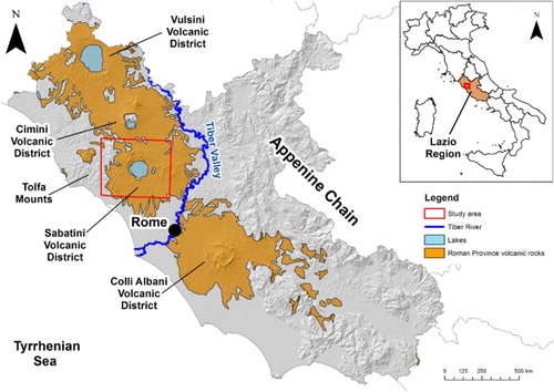
The SVD is one of the Quaternary volcanic districts of the Roman province. (CitationPeccerillo, 2005; CitationSottili, Palladino, & Zanon, 2004). It is located in the Lazio Region (Central Italy), about 30 km northwest of Rome (). The volcanic deposits cover an area of about 1800 km2 from the Tiber valley (eastward) to the Tolfa Mounts (westward) (CitationFuniciello & Parotto, 1978).
Figure 1. Location of the study area.
The origin of the K-rich magmatic activity is related to the development of the eastern extensional structures of the Tyrrhenian basin, between the orogenic belt of the Apennines and the slow spreading center of the Tyrrhenian Sea. The SVD activity started about 800 ka (CitationKarner, Marra, & Renne, 2001) from fissure eruptions of both acidic and basic formations (CitationMattias & Ventriglia, 1970), aligned on NW–SE and NE–SW directions (CitationAcocella & Funiciello, 2002, Citation2006). The volcanic rocks derive from magmas originally hosted both in deep and shallow reservoirs (CitationConticelli, Francalanci, Manetti, Cioni, & Sbrana, 1997). The volcanic formations overly continental and marine Pliocene and Pleistocene deposits and allochthonous units (CitationMazza, La Vigna, & Alimonti, 2014).
The morphology of the pre-volcanic basement is strictly connected to the tectonic evolution of this area, which created a horst and graben framework (Pre-volcanic elevation map reported on the map). The basement shows an E-W depression, related to the migration of volcanic activity from the east to west (CitationDe Rita, Funiciello, Rossi, & Sposato, 1983). The deepest sections of the pre-volcanic basement correspond to the main emission centers and calderas, localized in the area of Bracciano Lake, and in the volcanic districts of Martignano, Baccano and Sacrofano (CitationBuonasorte, Carboni, & Conti, 1991)
Volcanological and geochronological data, reported in former studies, show that the SVD volcanism encompassed a variety of eruption styles such as lava flows, pyroclastic flows and pyroclastic falls deposits (CitationCioni, Laurenzi, Sbrana, & Villa, 1993), characterized by different intensities and magnitudes (CitationSottili, Palladino, Gaeta, & Masotta, 2012).
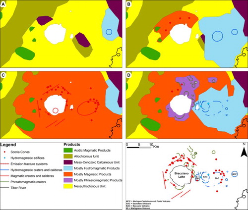
CitationDe Rita, Funiciello, Corda, Sposato, and Rossi (1993) divided the SVD evolution in four steps, as summarized in .
The first SVD activity started in the eastern sector with the development of the Morlupo-Castelnuovo di Porto volcano ((A)). During this phase, acid trachytic deposits were erupted.
The volcanic activity migrated westward, to the Sacrofano area. Lava flows and fall units are typical of this activity, which represents the most widespread and enduring phase of the SVD (500-360 ky BP). The Sacrofano activity started simultaneously with some cinder cones aligned along extensional faults located north of Bracciano Lake ((B)).
Around 400-300 ky BP a paroxysmal stage developed all over the district ((C)). The strong emission rate determined a sector collapse within the district and the development of a volcano-tectonic depression, which hosts Bracciano Lake (CitationDe Rita, Rodani, Rosa, & Puzzilli, 1997).
The last stage of volcanism was characterized by violent hydromagmatic eruptions from Martignano, Baccano and other smaller emission centers in the eastern sector of the SVD, ((D)). The activity in the SVD ceased around 80 ky BP with the emission of the Baccano units and the caldera collapse (CitationDe Rita & Zanetti, 1986a, Citation1986b).
Figure 2. Evolution of the SVD (modified from CitationDe Rita, Funiciello, et al., 1993). (A) Pre-volcanic structure and development of the first emissions centers; (B) The Sacrofano hydromagmatic activity and magmatic activity in the northern sector; (C) Paroxysmal stage of the magmatic activity in the SVD and (D) The final phase of the SVD activity.
2.2. Hydrogeological and hydrological settings
Two main aquifers can be distinguished in the SVD area:
the regional volcanic aquifer within the SVD deposits, recharged by rainfall infiltration (CitationBoni, Bono, & Capelli, 1986; CitationCapelli et al., 2005).
The carbonate thermal aquifer, confined in deeper Meso-Cenozoic units and separated from the volcanic aquifer by the clayey and allochthonous low-permeability basement (CitationBono, 1981).
The regional volcanic aquifer is made up of both porous (pyroclastic units) and fractured (lava flows) layers. Porous layers may show marked lateral and vertical heterogeneities according to the depositional framework. Even though volcanic units are inhomogeneous in term of geometry and hydraulic properties, at regional scale all the volcanic aquifer layers can be considered a large continuous multilayered aquifer (CitationMaruffi, 1970; CitationMazza et al., 2014). Therefore, groundwater circulation is affected by the physical characteristics of volcanic units as well as the morphologies of volcanic structures and the pre-volcanic aquiclude. Thermal and mineral springs such as the Stigliano, Claudia, Manziana and Nepi, are clear examples of localized rising water from the deeper carbonate aquifer (CitationBoni, Bono, & Capelli, 1986; CitationBoni, Bono, & Capelli, 1988; CitationCamponeschi & Lombardi, 1969; CitationLombardi & Giannotti, 1969). The main groundwater discharge in the SVD occurs as base-flow of the drainage network like linear springs rather than punctual springs (CitationMazza et al., 2014). Therefore, in spite of their limited length and the limited size of their catchment basin, watercourses have a constant flow because they are continuously supplied by groundwater recharge (CitationBaldi, Ferrara, Masselli, & Pieretti, 1973). The Bracciano and Martignano Lakes represent the level of the regional aquifer, while the Monterosi Lake is related to a perched aquifer.
3. Material and methods
A hydrogeological survey was carried out from March to September 2009 over an area of about 800 Km2. The location of every survey point was obtained using a global positioning system (GPS) receiver, while the elevation was determined from the most detailed topographic map resource (Technical Regional Chart (CTR) at 1:10,000 scale ED 50 UTM 33N Projected Coordinate Systems) (CitationRegione Lazio, 1990). The 1:50,000 scale SVD hydrogeological map was produced using the IGM (Military geographic institute) topographic map types, modified by ‘Studio G. Marinelli – Roma’. The 1:50,000 scale geological map produced by CitationDe Rita, Di Filippo, and Sposato (1993) was used to classify the outcropping volcanic units in to hydrogeological complexes, according to the method described in CitationCapelli et al. (2005).
During the hydrogeological survey, 221 water table levels under static conditions were measured using a contact meter, in wells used for domestic, agricultural, livestock and drinking water purposes. The flow rate of 23 localized springs were measured using the volumetric method. Stream flow measurements, using a mini current meter, at 74 streams were made in the period from July to August to identify and quantify the discharge of the linear springs in the watercourses. Collected data were managed in a Microsoft Access Database and then, spatially analyzed in Esri ArcGIS 10.1. The potentiometric surface map was produced using the triangular interpolation method and then digitized in ArcGIS.
Geological and construction information (such as the bottom depth and screened interval) for each well were reviewed, in order to identify and separate the high productivity regional aquifer from the perched and low productivity ones. Wells producing water from perched aquifers were not used in the development of the hydrogeological map. The non-homogeneous data collection network and the lack of technical information about some measured wells present a level of uncertainty in development of the hydrogeological map. Nevertheless, at the regional scale these issues were considered negligible.
The sedimentary pre-volcanic basement was studied in detail using the stratigraphy of several boreholes and geophysical data, collected for geothermal research in the 1980s (CitationBuonasorte et al., 1991), integrated with borehole stratigraphic data collected during the survey (reported in the cross sections on the Main Map).
The hydrogeological cross sections were produced using data from several borehole data coming from different databases, such as CitationLINQ (2010), CitationISPRA (2010; retrieved from http://sgi.isprambiente.it/GMV2/index.html), ENEL geothermal exploitation database (CitationBaldi et al., 1982; CitationENEL, 1987 retrieved from http://unmig.sviluppoeconomico.gov.it/unmig/geotermia/inventario/rapporto.asp?id=16; CitationENEL-VDAG-URM, 1994), municipal service bureau data and geological reports by freelance geologists.
4. Results and discussion
4.1. Hydrogeological complexes
The SVD formations show wide lateral and vertical lithologic variations deriving from bedding and textural features. The hydrogeological complexes were defined on the basis of the stratigraphy, structural characteristics and the permeability of each formation, in order to understand their role in groundwater circulation (CitationBaiocchi, Dragoni, Lotti, Luzzi, & Piscopo, 2006; CitationBaldi, Decandia, Lazzarotto, & Calamai, 1974; CitationBoni, Bono, & Capelli, 1986; CitationBoni, Bono, Capelli, Lombardi, & Zuppi, 1986; CitationCapelli et al., 2005). Hydrogeological complexes have been used in former regional studies to classify the Quaternary volcanic domains of Lazio Region. CitationBrunamonte, Cosentino, D’amico, Prestininzi, and Romagnoli (1987) and CitationBoni et al. (1988) distinguished two main hydrogeological complexes, indistinct pyroclastic deposits and lava flow deposits. CitationVentriglia (1990) and CitationCapelli et al. (2005) further refined the hydrogeological complexes, distinguishing the phreatomagmatic complex from the pyroclastic one.
This study refined the classification of hydrogeological complexes in more detail given the availability of more recent hydrogeological data and the higher work-scale. Volcanic units of the SVD were classified as listed below, according to the eruption style (CitationDe Rita, 1993), given that similar emplacement dynamics produce similar textural properties of the deposits:
Pyroclastic fall deposits represent an accumulation of products ejected from a crater or fracture, characterized by a variable grain size, spanning from scoria to ash. The geometry depends on the eruptive column height and wind pattern. They exhibit mantle-bedding stratification and maintain a uniform thickness over relatively short distances. They show substantial primary porosity.
Pyroclastic flow deposits originating from subaerial eruptions of fluidized masses of rock fragments and gases. They are massive, chaotic and mostly lithoid deposits and their geometry depends on the pre-existing morphology. They are characterized by variable primary and secondary porosity.
Phreatomagmatic products derived from a water-magma interaction. The mantle-bedding geometry shows a thickening in topographic depressions. These deposits show a thin stratification between different grain size deposits, so they are characterized by a low vertical primary porosity.
Lava flows are the result of the solidification of outpouring moving lava. Their geometry depends on the pre-existing morphology and they are characterized by secondary porosity due to either cooling fractures or fragile deformation.
4.2. Regional aquifer geometry and groundwater pattern
The SVD is the result of various and widespread volcanic activity, with the development of several emission centers and the emplacement of units characterized by different permeability. The groundwater elevation map, produced from the experimental data, confirms the hydrogeological pattern described in previous studies (CitationCamponeschi & Lombardi, 1969; CitationCapelli et al., 2005; CitationLombardi & Giannotti, 1969). The pre-volcanic basement elevation was determined using geophysical and stratigraphic data reported in previous studies, integrated with information collected during this study. The basement morphology is shown on the map as contours (50 m interval) at 1:150,000 scale.
The SVD was divided in to five sections in order to describe hydrogeological features supported by the five hydrogeological cross sections shown on the map.
4.2.1. Northern sector
The northern sector is characterized by the outcrop of the northern pyroclastic fall deposits (Np) complex and the interbedded Lava (la) complex. These deposits were erupted by several scoria cones, which compose the upper part of the regional aquifer. The lower part of the regional aquifer is composed of the Coarse grained Bracciano pyroclastic flow (CgB), by the Sabatinian Red Tuff with Black Scoria (RTBS) complexes, as identified in drill hole data (CitationCioni, 1993), and by undifferentiated volcanic units (D–D′ cross section). The groundwater pattern shows a close relation with the Pre-volcanic (Pre) complex morphology, especially where it crops out (at a mean elevation of around 400 m a.s.l.). Moving southward the Pre elevation rapidly drops due to volcano-tectonic collapse, then the groundwater morphology is related to Bracciano Lake (164 m a.s.l.),which represents the level of the regional water table and the basal level of most the northern groundwater circulation. Part of the northern aquifer also drains toward the Mignone River basin (westward) and the Treia River basin (northward and eastward) with an overall measured discharge of linear springs of around 500 L/s. The presence of fine grained hydromagmatic units (h), erupted by local centers and characterized by a low hydraulic productivity, can support perched aquifers, as detected at the Monterosi Lake.
4.2.2. Eastern sector
The eastern sector is characterized by the widespread outcrop of the Hydromagmatic (h) complex, composed of the units of the final emission centers of Baccano, Martignano, and other minor ones. The alternating deposition of ash and pumice layers allows the formation of several minor perched aquifers, not represented on the hydrogeological map, which recharge local springs often characterized by seasonal behavior. These aquifers crop out in morphologically depressed areas forming Monterosi, Baccano and Stracciacappe lakes, although some of them are drained by canals.
The regional aquifer is hosted within the RTBS, Southeastern minor pyroclastic flows (SE), and Sacrofano fall pyroclastic (Sfp) complexes (E–E' cross section). They are underlain by the Sacrofano lower pyroclastic flow complex (Slp), acting as a regional aquiclude. A small portion of groundwater is drained toward the Bracciano Lake, whereas the main drainage pattern is toward the southeast to the Tiber River, out of the study area. In the southeastern peripheral area, the linear springs of the Valchetta Stream and Piazza d’Armi Trench drain the aquifer with a mean discharge of around 300 L/s.
4.2.3. Southern sector
The Southern sector is characterized by outcrops of the SE, la and Sfp complexes. The lava flows form a continuous plateau interbedded with the pyroclastic deposits. Where la appears unfractured, it might act as aquiclude for local perched aquifers (not represented on the hydrogeological map). The regional aquifer is mostly hosted within the RTBS, Sfp and in the fractured la complexes (A–A' cross section), and it is laterally recharged by the Bracciano Lake. The aquifer discharges southward where the Pre complex crops out. The regional aquifer is drained by the Arrone Stream (around 200 L/s), starting from an elevation of around 140 m a.s.l. The Arrone Stream, the only natural surface discharge of the Bracciano Lake, is isolated from the lake by a dam system, so most of the river flow rate comes from the regional aquifer discharge and a minor part is related to sewage discharge. The Pre complex shows a NW–SE horst structure related to the Cesano Horst, which creates a piezometric mound separating groundwater flow to the Valchetta Stream basin (East) from flow toward the Arrone Stream basin (West).
4.2.4. Southwestern sector
The southwestern sector is mostly characterized by the outcropping of the CgB complex. The regional aquifer is here represented by the fractured la complex, emplaced on the RTBS (B–B' cross section), which directly overlies the undifferentiated SVD volcanic units and the Pre complex on the southern edge of the study area. The groundwater pattern is affected by the Pre morphology and the geometry of buried volcanic formations. In fact, southwest of Bracciano Lake, a NW–SE groundwater divide can be recognized, probably related to the presence of fracture systems, from which the la plateau was erupted, and later buried by the deposition of CgB, fine grained Bracciano pyroclastic flow (FgB) and Sfp complexes. The groundwater divide determines minor groundwater discharge directed northeastward to Bracciano Lake and the main groundwater discharge southward to the city of Rome. The regional aquifer is drained by some streams (about 70 L/s) in the peripheral area, where the Pre complex crops out. Perched aquifers, hosted within the CgB complex, recharge some minor springs, which flow out where the FgB aquiclude crops out.
4.2.5. Western sector
The Western sector is characterized mostly by the outcrop of CgB, RTBS and Peperini Listati (PL) complexes. The regional aquifer thickness, made up by la and RTBS complexes, decreases moving westward, in a strict relationship with the morphology of the Pre complex (C–C' cross section). The uplift of the Pre complex, due to the rapid emplacement of the Tolfa-Cerite-Manziate (TCM) complex (CitationCimarelli & De Rita, 2006), created a groundwater divide that splits flow paths eastward to Bracciano Lake and westward to the Mignone River basin. Linear springs, with an overall discharge rate of about 80 L/s, occur along western boundary of the SVD, where the Pre complex crops out. Some perched aquifers, hosted within the CgB complex and underlain by the CfB were also detected.
5. Conclusions
The hydrogeological map of the SVD provides the most detailed mapping to date of the groundwater resources of the study area. This work focused on the delineation of the regional productive volcanic aquifer. The volcanic and sedimentary formations were classified into 15 hydrogeological complexes. Around 1500 L/s of natural discharge were measured in linear and localized springs.
The hydrogeological map of the SVD provides a baseline for long time monitoring of water resource conditions. Repeated water level measurements in wells used in this study can help evaluate efforts to use the groundwater in a sustainable manner.
Software
All data processing and spatial analysis regarding the map were performed by GIS software (Arc Gis 10.1). Cross sections were realized by Corel Draw X4.
Final editing of the map was performed by Adobe Illustrator CS.
HYDROGEOLOGY OF THE SABATINI VOLCANIC DISTRICT (CENTRAL ITALY).zip
Download Zip (170.4 KB)HYDROGEOLOGY OF THE SABATINI VOLCANIC DISTRICT (CENTRAL ITALY).pdf
Download PDF (60.3 MB)Acknowledgements
The authors thank the Mariani family for its essential logistic help during the hydrogeological survey. The authors thank Dr M. Nocentini and Prof G. Robbins for the precious suggestions to improve the manuscript and the map. The authors also thank Mrs Clio, because nowhere was too arduous with you. A special late thanks is for Tommaso Raspagliosi for having taught that everything is possible. A special final acknowledgment goes to Renato Biascica, for the suggestion to held the head high during hard times.
Disclosure statement
No potential conflict of interest was reported by the authors.
ORCID
S. Viaroli http://orcid.org/0000-0002-2521-7463
Related Research Data
References
- Acocella, V., & Funiciello, R. (2002). Transverse structures and volcanic activity along the Tyrrhenian margin of central Italy. Bollettino della Societa Geologica Italiana, Volume Speciale, 1, 739–747.
- Acocella, V., & Funiciello, R. (2006). Transverse systems along the extensional Tyrrhenian margin of central Italy and their influence on volcanism. Tectonics, 25(TC2003), doi:10.1029/2005TC001845
- Baiocchi, A., Dragoni, W., Lotti, F., Luzzi, G., & Piscopo, V. (2006). Outline of the hydrogeology of the Cimino and Vico volcanic area and of the interaction between groundwater and Lake Vico (Lazio Region, Central Italy). Bollettino della Societa Geologica Italiana, 125, 187–202.
- Baiocchi, A., Lotti, F., & Piscopo, V. (2011). Influence of hydrogeological setting on the arsenic occurrence in groundwater of the volcanic areas of central and southern Italy. AQUAmundi, 131–142. doi:10.4409/Am-035-11-0035
- Baldi, P., Buonasorte, G., Ceccarelli, A., Ridolfi, A., D’Offizi, S., D’Amore, F., … Toro, B. (1982). Contributo alla conoscenza delle potenzialità geotermiche della Toscana e del Lazio. PFE-RF 15. Consiglio Nazionale delle Ricerche.
- Baldi, P., Decandia, F. A., Lazzarotto, A., & Calamai, A. (1974). Studio geologico del substrato della copertura vulcanica laziale nella zona dei laghi di Bolsena, Vico e Bracciano. Memorie della Società Geologica Italiana, 13, 575–606.
- Baldi, P., Ferrara, G. C., Masselli, L., & Pieretti, G. (1973). Hydrogeochemistry of the region between Monte Amiata and Rome. Geothermics, 2(3–4), 124–128. doi:10.1016/0375-6505(73)90020-5
- Bertini, M., D’Amico, C., Deriu, M., Tagliavini, S., & Vernia, L. (1971). Foglio 143 Bracciano. In N. T. Grafica (Ed.), Note Illustrative della Carta Geologica d’Italia alla scala 1:100000 (pp. 1–68). Roma.
- Boni, C., Bono, P., & Capelli, G. (1986). Schema idrogeologico dell’Italia Centrale. Memorie della Società Geologica Italiana, 35, 991–1012.
- Boni, C., Bono, P., & Capelli, G. (Cartographer). (1988). Carta Idrogeologica del territorio della Regione Lazio. Scala 1:250.000. Roma, Italy: Special pubblication Lazio Region.
- Boni, C., Bono, P., Capelli, G., Lombardi, G., & Zuppi, G. M. (1986). Contributo all’Idrogeologia dell’Italia centrale: analisi critica e metodi di ricerca. Memorie della Società Geologica Italiana, 35, 947–956.
- Bono, P. (1981). Valutazione preliminare del potenziale geotermico della Regione Lazio. Geologica Romana, 20, 69–78.
- Brunamonte, F., Cosentino, D., D’amico, L., Prestininzi, A., & Romagnoli, C. (Cartographer). (1987). Carta dei sistemi idrogeologici del territorio della Regione Lazio. Rome, Italy: Università degli Studi di Roma “La Sapienza”.
- Buonasorte, G., Carboni, M. G., & Conti, M. A. (1991). Il substrato Plio-Pleistocenico delle vulcaniti sabatine: considerazioni stratigrafiche e paleoambientali. Bollettino della Societa Geologica Italiana, 110, 35–40.
- Camponeschi, B., & Lombardi, L. (1969). Idrogeologia dell’area vulcanica Sabatina. Memorie della Società Geologica Italiana, 8, 25–55.
- Capelli, G., Mazza, R., & Gazzetti, C. (2005). Strumenti e strategie per la tutela e l’uso compatibile della risorsa idrica nel Lazio (Vol. 78). Bologna: Pitagora.
- Cavarretta, G., De Rita, D., Rosa, C., & Sposato, A. (1990). Caratteri geologico-petrografici del ‘tufo rosso a scorie nere’ Sabatino. Convegno Scientifico annuale del Gruppo Nazionale per la Vulcanologia, Ravenna.
- Cimarelli, C., & De Rita, D. (2006). Relatively rapid emplacement of dome-forming magma inferred from strain analyses: The case of the acid Latian dome complexes (Central Italy). Journal of Volcanology and Geothermal Research, 158, 106–116. doi:10.1016/j.jvolgeores.2006.04.015
- Cioni, R. (1993). Il Complesso di Bolsena e il Vulcanismo Alcalino-Potassico del lazio Settentrionale. (PhD thesis), University of Pisa, Pisa.
- Cioni, R., Laurenzi, M. A., Sbrana, A., & Villa, I. M. (1993). 40Ar/39Ar chronostratigraphy of the initial activity in the Sabatini Volcanic Complex (Italy). Bollettino della Societa Geologica Italiana, 112, 251–263.
- Conticelli, S., Francalanci, L., Manetti, P., Cioni, R., & Sbrana, A. (1997). Petrology and geochemistry of the ultrapotassic rocks from the Sabatini Volcanic District, central Italy: The role of evolutionary processes in the genesis of variably enriched alkaline magmas. Journal of Volcanology and Geothermal Research, 75(1–2), 107–136. doi:10.1016/S0377-0273(96)00062-5
- De Rita, D. (1993). Il vulcanismo. In S. G. Italiana (Ed.), Guide Geologiche Regionali (pp. 50–64). Lazio: BE-Ma.
- De Rita, D., Di Filippo, M., & Sposato, A. (Cartographer). (1993). Carta geologica del Complesso Vulcanico Sabatino. Rome, Italy: CNR.
- De Rita, D., Funiciello, R., Corda, L., Sposato, A., & Rossi, U. (1993). Volcanic unit. In M. Di Filippo (Ed.), Sabatini volcanic complex (Vol. 11, pp. 33–79). Roma: Consiglio Nazionale Delle Ricerche.
- De Rita, D., Funiciello, R., Rossi, U., & Sposato, A. (1983). Structure and evolution of the Sacrofano-Baccano caldera, Sabatini volcanic complex, Rome. Journal of Volcanology and Geothermal Research, 17, 219–236. doi: 10.1016/0377-0273(83)90069-0
- De Rita, D., Rodani, S., Rosa, C., & Puzzilli, M. L. (1997). Il settore sud-occidentale del Distretto Vulcanico Sabatino: stratigrafia ed evoluzione alla luce di dati di sondaggio e rilevamento. Bollettino della Societa Geologica Italiana, 116, 319–334.
- De Rita, D., & Zanetti, G. (1986a). Caratteri vulcanologici e deposizionali delle piroclastiti di Stracciacappe (Sabatini Orientali, Roma). Memorie della Società Geologica Italiana, 35, 667–677.
- De Rita, D., & Zanetti, G. (1986b). I centri esplosivi di Baccano e di Stracciacappe (Sabatini Orientali, Roma): analogie e differenza della modellistica esplosiva in funzione del grado di interazione acqua/magma. Memorie della Società Geologica Italiana, 35, 689–697.
- ENEL. (1987). Inventario delle Risorse geotermiche nazionali:Regione Lazio. Retrieved from http://unmig.sviluppoeconomico.gov.it/unmig/geotermia/inventario/rapporto.asp?id=16
- ENEL-VDAG-URM. (1994). Aggiornamento delle caratteristiche di superficie e profonde del Lazio settentrionale – Relazione inedita, ENEL – Università degli studi ‘La Sapienza,’ Dipartimento Scienze della Terra, 11.
- Funiciello, R., & Parotto, M. (1978). Il substrato sedimentario nell’area dei Colli Albani: considerazioni geodinamiche e paleogeografiche sul margine tirrenico dell’Appennino Centrale. Geologica Romana, 17, 233–287.
- Gragnanini, V., Mastrorillo, L., Vignaroli, G., Mazza, R., & Rossetti, F. (2015). Hydrolithology of the area between Tuscany, Latium and Umbria regions (Italy). Journal of Maps, 11(3), 464–479. doi:10.1080/17445647.2014.942528
- ISPRA. (2010). Istituto Superiore per la Prevenzione e Ricerca Ambientale, Archivio nazionale delle indagini nel sottosuolo (L.464/84). Retrieved from http://sgi.isprambiente.it/GMV2/index.html
- Karner, D. B., Marra, F., & Renne, P. R. (2001). The history of the Monti Sabatini and Alban Hills volcanoes: Groundwork for assessing volcanic-tectonic hazards for Rome. Journal of Volcanology and Geothermal Research, 107(1–3), 185–215. doi:10.1016/s0377-0273(00)00258-4
- La Vigna, F., Mazza, R., Amanti, M., Di Salvo, C., Petitta, M., Pizzino, L., … Succhiarelli, C. (2016). Groundwater of Rome. Journal of Maps. doi:10.1080/17445647.2016.1158669
- LINQ. (2010). Laboratorio di Idrogeologia dell’Università di Roma Tre, Banca dati dei punti di osservazione. Roma.
- Lombardi, G., & Giannotti, G. P. (1969). Idrogeologia della zona a sud-est del Lago di Bracciano. Bollettino della Societa Geologica Italiana, 88, 107–121.
- Maruffi, G. (1970). Ricostruzione mediante prospezione geofisica dell’andamento del basamento conduttivo nella regione vulcanica dei Monti Sabatini e, marginalmente, in quella dei Monti Cimini. Rendiconti della Società Italiana di Mineralogia e Petrologia, 26, 205–217.
- Masotta, M., Gaeta, M., Gozzi, F., Marra, F., Palladino, D. M., & Sottili, G. (2010). H2O- and temperature-zoning in magma chambers: The example of the Tufo Giallo della Via Tiberina eruptions (Sabatini Volcanic District, central Italy). Lithos, 118, 119–130. doi:10.1016/j.lithos.2010.04.004
- Mattias, P. P., & Ventriglia, U. (1970). La Regione Vulcanica dei Monti Sabatini e Cimini. Memorie della Società Geologica Italiana, 9, 331–384.
- Mazza, R., La Vigna, F., & Alimonti, C. (2014). Evaluating the available regional groundwater resources using the distributed hydrogeological budget. Water Resources Management, 28(3), 749–765. doi:10.1007/s11269-014-0513-6
- Peccerillo, A. (2005). Plio-Quaternary volcanism in Italy – Petrology, Geochemistry, Geodynamics. Berlin: Springer-Verlag.
- Preziosi, E., Giuliano, G., & Vivona, R. (2010). Natural background levels and threshold values derivation for naturally As, V and F rich groundwater bodies: A methodological case study in Central Italy. Environmental Earth Sciences, 61, 885–897. doi:10.1007/s12665-009-0404-y
- Procesi, M., Cantucci, B., Buttinelli, M., Armezzani, G., Quattrocchi, F., & Boschi, E. (2013). Strategic use of the underground in an energy mix plan: Synergies among CO2, CH4 geological storage and geothermal energy. Latium Region case study (Central Italy). Applied Energy, 110, 104–131. doi:10.1016/j.apenergy.2013.03.071
- Regione Lazio (Cartographer). (1990). C.T.R. Carta Tecnica Regionale. 1:10,000 scale.
- Sappa, G., Ergul, S., & Ferranti, F. (2014). Geochemical modeling and multivariate statistical evaluation of trace elements in arsenic contaminated groundwater systems of Viterbo Area, (Central Italy). Springerplus, 3(237), 19. doi:10.1186/2193-1801-3-237
- Sottili, G., Palladino, D. M., Gaeta, M., & Masotta, M. (2012). Origins and energetics of maar volcanoes: examples from the ultrapotassic Sabatini Volcanic District (Roman Province, Central Italy). Bulletin of Volcanology, 74, 163–186. doi:10.1007/s00445-011-0506-8
- Sottili, G., Palladino, D. M., Marra, F., Jicha, B., Karner, D. B., & Renne, P. R. (2010). Geochronology of the most recent activity in the Sabatini Volcanic District, Roman Province, central Italy. Journal of Volcanology and Geothermal Research, 196, 20–30. doi:10.1016/j.jvolgeores.2010.07.003
- Sottili, G., Palladino, D. M., & Zanon, V. (2004). Plinian activity during the early eruptive history of the Sabatini Volcanic District, Central Italy. Journal of Volcanology and Geothermal Research, 135, 361–379. doi:10.1016/j.jvolgeores.2004.03.019
- Ventriglia, U. (Cartographer). (1990). Carta Idrogeologica – Regione Vulcanica Sabatina. Roma: Assessorato Lavori Pubblici, Viabilità e Trasporti.
- Ventriglia, U. (2002). Circolazione delle acque superificiali – Descrizione dei bacini Geologia del territorio del Comune di Roma. Afragola, NA: Casa Editrice Cerbone s.r.l.
- Viaroli, S., Cuoco, E., Mazza, R., & Tedesco, D. (2016). Dynamics of natural contamination by aluminium and iron rich colloids in the volcanic aquifers of Central Italy. Environmental Science and Pollution Research, 23, 19958–19977. doi:10.1007/s11356-016-7198-8