
ABSTRACT
Along the northern Ionian margin of Calabria, three Neogene basins comprise wedge-top depozones containing syntectonic deposits which cover the frontal part of the fold-thrust belt. One of the best exposed onshore allochthonous siliciclastic successions is represented by the Cariati Nappe, cropping out in the Cirò Basin. Field geological mapping and aerial interpretations were used to characterize the stratigraphy and tectonics of the area between the Arso Stream and Nicà River catchments (about 170 km2), including a Paleozoic metamorphic basement complex unconformably overlain by Upper Oligocene to Quaternary siliciclastic deposits and minor carbonates. This paper presents a 1:25,000 scale map of the Ionian study area, providing lithological and structural data towards reconstructing its tectono-sedimentary evolution.
1. Introduction
The geology and morphological architecture of the Calabrian Arc terranes (Southern Italy) are the result of accretionary processes along its eastern flank (Ionian Sea), and rifting processes along its western flank (Tyrrhenian Margin), during the Neogene (e.g. CitationCritelli & Le Pera, 1995, Citation1998; CitationCritelli, Muto, Tripodi, & Perri, 2011, Citation2013; CitationMuto & Perri, 2002; CitationZecchin, Praeg, Ceramicola, & Muto, 2015). The present geological setting of the northern Ionian margin is a wedge-top depozone, which is located above the thrust-sheets of the Calabrian Arc and the southern Apennine terranes (CitationCritelli & Le Pera, 1998; CitationCritelli, Muto, Perri, & Tripodi, 2017; CitationPerri et al., 2012). The southern Apennine thrust and fold belt and the northern Calabrian terranes form an orogenic front, which is associated with foreland-basin systems (e.g. CitationCritelli, 1999; CitationDeCelles & Giles, 1996). In particular, deformed Neogene longitudinal basins (e.g. Rossano, Cirò, and Crotone Basin) represent the wedge-top depozones, into which syntectonic sedimentary cover accumulated over the frontal part of the fold-thrust belt.
The stratigraphy and structural architecture of the wedge-top basins of Ionian Calabria and the timing of deformation have been influenced by compressive structures leading to the development of distinct and asymmetric depocentres. Such on-land structures are similar to doubly verging thrusts (CitationCritelli et al., 2011; CitationDoglioni, Merlini, & Cantarella, 1999; CitationMuto, Spina, Tripodi, Critelli, & Roda, 2014; CitationRoveri, Bernasconi, Rossi, & Visentin, 1992; CitationVan Dijk et al., 2000) documented in the Ionian offshore and associated with the activity of NW–SE striking shear zones (CitationBrutto et al., 2016; CitationKnott & Turco, 1991; CitationMuto et al., 2015; CitationTripodi, Muto, & Critelli, 2013; CitationVan Dijk et al., 2000). In the study area, the strain partitioning along left-lateral strike-slip faults led to the development of transpressional features, such as the Cariati Nappe (CN). This represents one of the best exposed onshore allochthonous siliciclastic successions of southern Italy (∼1000 m thick), cropping out along the Ionian margin of the Calabrian Arc. It is thrust over the Upper Tortonian–Messinian sequences and shows an internal architecture that reflects the interplay between tectonics and relative sea-level changes. A Late Messinian-Quaternary succession unconformably overlies the CN.
A first characterization of the CN by CitationMuto et al. (2014) analyzed the tectono-stratigraphic evolution of the allochthonous deposits of the Ionian basin, whereas the present paper draws on an in-depth geological and structural survey of the area, between the Arso Stream and Nicà River, aiming at providing more detail of the allochthonous deposits and at describing the stratigraphy of the whole succession from Paleozoic metamorphic basement to Pliocene–Pleistocene deposits. Geological units that were not formally recognized before are here described with informal names deriving from a geographic place where they typically crop out. In addition, the Neogene-Quaternary structural setting of the study area has been determined, providing information for characterizing the tectono-stratigraphic evolution of this sector of the Calabrian Arc.
2. Geological setting
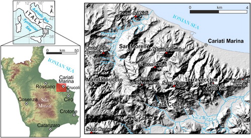
The study area is located along the eastern sector of northern Calabria (Southern Italy), between the Arso Stream and Nicà River catchments (). The Calabrian Arc terranes include Paleozoic crystalline basement, thrust over ophiolite-bearing units of the Neo-Tethys domain during the Eocene. These units have covered the Mesozoic carbonate rocks of the Apenninic Maghrebide chain since the Mid-Miocene (CitationAmodio Morelli et al., 1976; CitationDewey, Helman, Turco, Hutton, & Knott, 1989; CitationMessina et al., 1994; CitationOgniben, 1973; CitationRossetti, Goffè, Moniè, Faccenna, & Vignaroli, 2004). On the Ionian side of the Calabrian terranes, the Paleozoic Alpine units and their Mesozoic cover are overlain by Neogene and Quaternary basin successions (CitationBarone, Critelli, Dominici, & Muto, 2008; CitationOgniben, 1973; CitationRoda, 1967; CitationZecchin et al., 2012). On the oldest units, a Serravallian to Pliocene terrigenous and carbonate sequence represents the infilling of the Calabrian foreland that can be subdivided into three main Neogene depocentres: the Rossano, Cirò and Crotone basins (CitationBarone et al., 2008; CitationMuto et al., 2014; Citation2015). The Calabrian terranes experienced a complex network of strike-slip faults and associated thrusts that strongly influenced the development of Neogene basins (CitationMaffione, Speranza, Cascella, Longhitano, & Chiarella, 2013; CitationMuto et al., 2014). For instance, the Cirò basin, located in an intermediate position between the Rossano and Crotone basins, lacks the Messinian evaporites (CitationBarone et al., 2008; CitationMuto et al., 2014). This suggests that a larger and previously continuous basin has been dissected into sub basins since the early Messinian (CitationBarone et al., 2008; CitationMatano, Critelli, Barone, Muto, & Di Nocera, 2014; CitationZecchin et al., 2013a, Citation2013b). The CN (CitationBonfiglio, 1964) represents a particularly anomalous clastic succession cropping out in the Cirò basin. It has been interpreted as an allochthonous sequence (CitationBonfiglio, 1964; CitationCotecchia, 1963) emplaced over the top of (post Messinian) terrigenous sediments (CitationRoda, 1967). The CN represents a back-thrust, initially propagated during the late Tortonian with displacement continuing during Messinian-Pliocene time in a left-lateral NW–SE oriented transpressive fault zone (CitationMuto et al., 2014). The basin succession of the CN is unconformably overlain by Pliocene to Upper Pleistocene succession made up of clay, sand and conglomerate, the latter forming a staircase of terraces, as observed north and south of the study area, in the Rossano (CitationCarobene, 2003; CitationCorbi et al., 2009; CitationRobustelli et al., 2009a; Citation2009b) and Crotone (CitationLucà, Robustelli, Conforti, & Fabbricatore, 2011; CitationZecchin, Nalin, & Roda, 2004) basins, respectively.
Figure 1. Location of the study area.
3. Methods
In order to reconstruct the stratigraphic and structural setting of the study area, we carried out a detailed geological survey of Cenozoic sedimentary deposits as well as mesostructural analysis of kinematic indicators on the fault planes and aerial-photo interpretation to characterize the structural features. In order to discriminate different deformation phases; stereoplots were developed using Daisy software.
To better illustrate the geometry of the main structures of the study area (about 170 km2), data were compiled on a 1:25,000 scale map. A Digital Elevation Model (DEM), derived from 1:5000 scale topographic maps of the Calabria Region, was used to derive a simplified topographic base with 50 m interval contour lines.
4. Stratigraphy
The studied succession has been subdivided into four groups: bedrock, autochthonous succession, CN succession, and Late Messinian-Pleistocene succession.
4.1. Bedrock
Bedrock crops out in the western sector of the study area and is represented by the Paleozoic Mandatoriccio complex (CitationLangone et al., 2010). It consists mainly of metapelite, meta-arenite, and metavolcanic rocks with rare intercalations of marble and granitic orthogneiss. Metasedimentary rocks are locally intruded by deeply weathered granodiorite bodies (e.g. CitationBorrelli, Critelli, Gullà, & Muto, 2015; CitationBorrelli, Perri, Critelli, & Gullà, 2012) and, very rarely, by pegmatite and aplite sheets.
4.2. Autochthonous succession
Autochthonous deposits unconformably overlie the Paleozoic basement. The succession starts with the Upper Oligocene–Lower Miocene Paludi Formation (CitationBonardi et al., 2005), consisting of red conglomerates evolving upwards to alternating sandstones and mudstones, and cropping out to the west of Mandatoriccio. The rhythmic alternation of sandstone and mudstone records gravity-driven-processes. Locally, at the base of the conglomeratic deposits, crystalline megaclasts derived from the Mandatoriccio complex occur. They are probably related to the instability of the basin margin during sedimentation.
The San Nicola Formation and the Clypeaster molasse (Serravallian–Tortonian) unconformably lie either on the Mandatoriccio complex or Paludi Formation, with a thickness of about 100 m, and represent the main substrate of Mandatoriccio village. The San Nicola Formation consists of clast-supported boulders and pebbles (a) of an alluvial–fluvial environment, passing upwards into conglomerates and coarse-grained sandstones of the Clypeaster molasse (b), accumulated in a shoreface environment.
Figure 2. The Autochthonous succession: (a) Coarse-grained sandstone with interbedded conglomerate intervals of San Nicola Formation (Serravallian–Tortonian) and sandstone of Clypeaster Molasse (b); (c) thin stratified diatomites and cherty clay of Tripoli Formation (Lower Messinian).
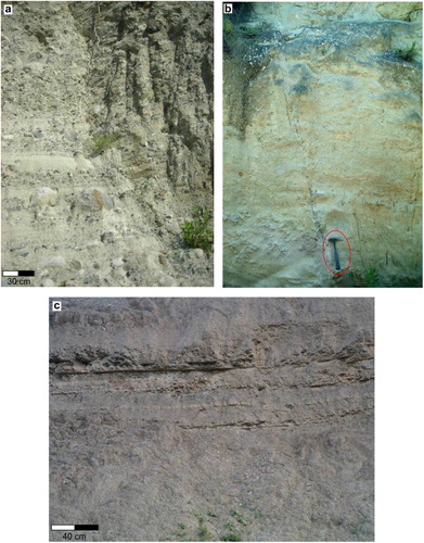
The San Nicola Formation and Clypeasters molasse pass upwards into the Ponda Formation (CitationMassari, Prosser, Capraro, Fornaciari, & Consolaro, 2010; CitationOgniben, 1955) which consists of 200 m thick Tortonian marly-claystone and silty sandstones interpreted to have been deposited in an offshore environment. Nearby Scala Coeli village, a lenticular sandstone deposit (Scala Coeli member) (up to 150 m in thickness) is included within marly-claystone deposits of the Ponda Formation (CitationCritelli et al., 2014a, Citation2014b). Cretaceous to Eocene olistostromes made up of the so-called Varicoloured Clays occur intercalated at different levels within the Ponda Formation.
Within the Ponda Formation, located between Pietra dell’Avvoltoio and Scala Coeli, there is a lenticular diatomaceous laminite outcrop of a few meters thick comprising a sapropel-like interval of the Lower Messinian Tripoli Formation (c). These deposits suggest that anoxic conditions due to water stratification preceded the Messinian Salinity Crisis. The contact between the Tripoli Formation and the Messinian clastic formations is only exposed near Scala Coeli and San Morello (CitationMuto et al., 2014).
4.3. CN succession
The CN succession overlies the Miocene Autochthonous succession across a tectonic contact. CN strata are characteristic of a range of depositional environments spanning fluvio-deltaic to offshore, recording two main relative sea-level rises.
The lowermost stratigraphic unit of the CN consists of Varicolored Clays (Cretaceous-Eocene) cropping out in the western sector of the study area, nearby Cozzo della Battaglia. The Varicolored Clays consist of clay and shale (mainly red, blue, and green in color) interbedded with calcilutites, calcarenites, greenish sandstones, and marls. Deposits are deformed by chaotic isoclinalic folds and microfolds.
The Varicolored Clays are unconformably overlain by the Upper Oligocene – Burdigalian Petraro Unit (a), which is in tectonic contact with the autochthonous succession in the central part of the study area, northward of Scala Coeli town. The Petraro Unit consists of a rhythmic alternation of coarse- to medium-grained sandstones and mudstone (50–250 cm thick), interpreted to be distal turbidites. The Petraro Unit is unconformably overlaid by the Pietra dell’Avvoltoio Unit (Langhian), made up of pebble conglomerates and coarse- to fine-grained sandstones (∼200 m thick, b), accumulated in braided channel-belts, and here interpreted to be the sub-aerial distributary portion of a deltaic system. Coarse-grained deposits are encased within red mudstones interpreted as flood-plain deposits. This unit rapidly passes upward to the 250 m thick Langhian–Serravallian Monte Palumbo Unit which consists, in its lower part, of massive sandstones (c), interpreted to be mouth bar deposits, passing upward to a rhythmic alternation of sandstone and mudstone couples up to 20 cm thick. The sandstone intervals show incomplete Bouma sequences suggesting that the unit is the result of turbidity flows.
Figure 3. The CN succession: (a) Alternation of well stratified sandstone and mudstone of Petraro unit (Upper Oligocene – Burdigalian); (b) stratified conglomerate and coarse-grained sandstone of Pietra dell’Avvoltoio unit (Langhian); (c) alternated sandstone strata and mudstone in torbidic facies of Monte Palumbo unit (Langhian–Serravallian); (d) stratified conglomerate with clasts and locally boulders of Cozzo della Madonna unit (Serravallian–Tortonian); (e) well stratified sandstone of Terravecchia unit (Serravallian–Tortonian); (f) mudstone with intercalation of thin arenite strata Morenile unit (Tortonian).
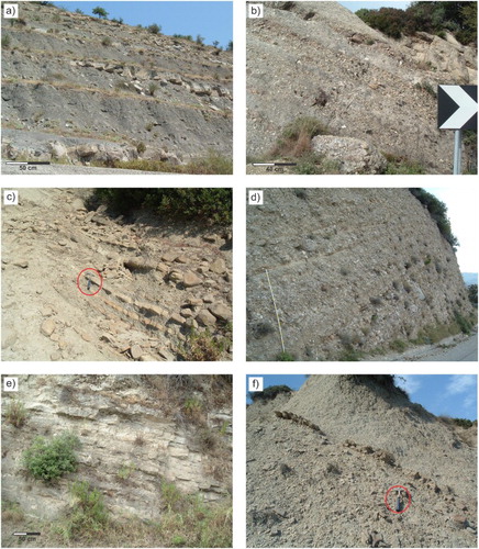
The Serravallian–Tortonian Cozzo della Madonna Unit (d) unconformably overlies the Monte Palumbo Unit. The 150 m in thick succession is composed of (i) clast- to matrix-supported conglomerates with well-rounded boulders and pebbles, and (ii) coarse- to medium-grained sandstones interpreted to have formed in a deltaic environment, through debris-flow processes. This unit is separated from the overlying Serravallian–Tortonian Terravecchia Unit by a gradational and heteropic contact. The Terravecchia Unit (∼150 m thick) consists of coarse- to medium-grained sandstones occurring in beds of up to 50 cm thick (e), locally including clay chips. Arenicolites, Chondrites, Skolithos, and Planotithes ichnogenera have been recognized. The unit is interpreted to be a submarine fan accumulated during low- and high-density gravity-flows.
The Terravecchia Unit passes upward to the Tortonian Morenile Unit cropping out between the Terravecchia town and the Arso Stream with a thickness of 200 m. The Terravecchia Unit consists of mudstone intervals up to 200 cm thick, separated by medium- to fine-grained sandstones occurring in beds of up to 10 cm thick. Such deposits are interpreted to have been formed by low-density turbidity flows and accumulated in an offshore environment. The Morenile Unit crops out on the inner flank of a NW–SE syncline and is the uppermost and youngest unit of the CN. It consists of mudstone with interbedded sandstone strata (f), here interpreted as low-density turbidity current deposits.
4.4. Late Messinian-Pleistocene succession
The Late Messinian-Pleistocene succession lies unconformably on the CN. Its lower Cozzo dei Nidi Unit (Late Messinian-Lower Pliocene interpreted) crops out on the southern side of the Arso Stream. It consists of grayish fossiliferous marls and clays alternating with thin turbidite sandstone beds.
The succession passes upwards to the Cinta del Rosello mixed siliciclastic–bioclastic sandstone (Upper Pliocene–Lower Pleistocene) cropping out along the Nicà River and correlated with the Scandale sandstone formation, outcropping south of study area (CitationCritelli et al., 2014a, Citation2014b). On the northwestern side of the Nicà River, the unit lies unconformably over the Petraro Unit. The Cinta del Rosello mixed sandstone is made up of unsegregated, cross-bedded siliciclastic–bioclastic sandstones (sensu CitationChiarella & Longhitano, 2012; CitationChiarella, Moretti, Longhitano, & Muto, 2016; CitationLonghitano, Chiarella, & Muto, 2014) interpreted to have been deposited in shoreface and offshore-transition environments.
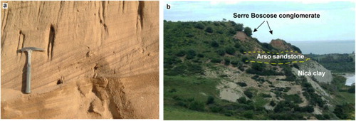
The overlying Lower Pleistocene Nicà clay consists of clay and gray blue marl without any apparent stratification or sedimentary structure. This unit has been correlated with the Cutro Formation outcropping in the Crucoli Geological Sheet (CitationCritelli et al., 2014a) and intersected by the offshore petroleum wells (CitationViDEPI project; unmig.sviluppoeconomico.gov.it/videpi/) drilled by Agip where it reaches 500 m in thickness. The Middle Pleistocene Arso Sandstone, correlated with the Torretta di Crucoli Syntheme occurring south of the study area (CitationCritelli et al., 2014a), crops out parallel to the coastline and is separated from the underlying Nicà clay by an erosional unconformity. It consists of a locally stratified and bioturbated medium and coarse-grained sandstone (a), with a thin layer of well-rounded gravel at its base. The Middle Pleistocene–Upper Pleistocene Serre Boscose conglomerate unconformably overlies the Mionene and Plio-Lower Pleistocene deposits (b). It consists of subrounded, pebbles with cobbles, sand and subordinate silt, with locally interbedded paleosols. The depositional environments include sub-aerial to submerged beaches. These deposits are arranged in a staircase of terraces the age of which has not been differentiated in the present study but can be correlated to the marine and alluvial terraces observed to the north, in the Rossano area (CitationCarobene, 2003; CitationCorbi et al., 2009; CitationRobustelli et al., 2009a; Citation2009b).
Figure 4. Pleistocene deposits: (a) Cross stratification in the Arso sandstone unit (Middle Pleistocene); (b) panoramic view of the Serre Boscose conglomerate (Middle Pleistocene–Upper Pleistocene), unconformably overlying the Arso sandstone (Middle Pleistocene). At the base, the Nicà clay (Lower Pleistocene) crops out.
5. Structural features
The main geological structure in the study area is a subvertical NW–SE striking, E dipping thrust (a), cropping out between the Arso Stream and the Nicà River, north of Scala Coeli (Main Map). In the central sector of the study area, the tectonic contact separates the Ponda and the Tripoli formations in the footwall- from the hangingwall CN succession (a). In the northwestern part of the study area, on the north side of the Arso Stream, the thrust is underlain by footwall Cozzo dei Nidi sandstone of late Messinian to lower Pliocene age (see Main Map).
Figure 5. (a) Panoramic view the ‘Cariati Nappe’ from west to east; (b) thrust associated with main tectonic contact. Bedding shown with blue lines; (c) N–S and west dipping thrust associated with tight folds; (d) left-lateral strike-slip fault in the Miocene deposits. Component fault planes shown with red lines; (e) normal E–W oriented fault in the Pleistocene deposits.
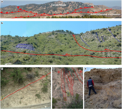
Within the CN succession, the west verging anticlines and synclines, with generally eastward dipping strata are related to the main thrust and to the splay ramps (b). The fold axes are mainly NW–SE oriented; subordinate N–S trends also occur (c). Similarly oriented mesoscopic folds have been widely observed near Terravecchia.
The main anticline located north of Petraro, has a NNW–SSE oriented axis and plunges toward the NNW. The Petraro Unit crops out in the core of the fold whereas the outer limbs are characterized by the remaining successions of the CN. Near Bosco di Cento Rale, a NW–SE oriented syncline with the Morenile Unit exposed in the core has been mapped. Fold axes in the area are curvilinear.
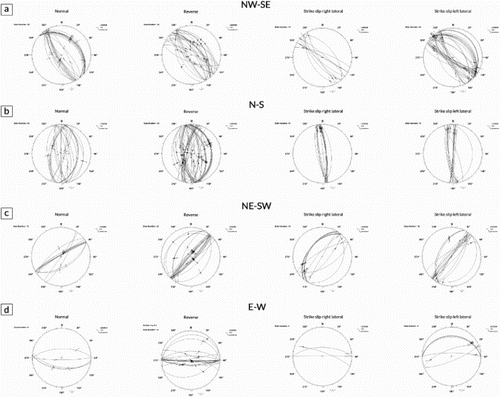
The faults surveyed in the study area are mainly NW–SE trending with strike-slip (left and right lateral), reverse and normal kinematics (). The distribution of fault kinematics has been distinguished according to trends and ages of displaced stratigraphic units. The NW–SE fault planes are widespread at the contact between the Autochthonous and the CN successions and between the substrate and the autochthonous Middle Miocene deposits (see Main Map). These structures are most frequently strike-slip with a reverse-slip component (i.e. oblique-slip) and dip-slip reverse faults (a). Along the main contact and at the mesocopic scale these faults exhibit typical transpressive geometry. They are left-lateral dominant (d) with a high angle of inclination and dipping towards the NE. Pleistocene deposits have been dissected by E–W striking, high angle normal faults with a component of right-lateral displacement (d), which also displace the staircase of terraces (e)
Figure 6. Schmidt net (lower hemisphere projection) of faults collected in the study area; data are subdivided according to strikes and kinematics.
Geological mapping revealed the occurrence of polyphase deformation. In fact, within the CN succession and mainly at the hangingwall of the main thrust, N to NE trending splay thrusts accommodate strike-slip deformation (c and b, c) in addition to fold axes showing evidence of re-folding at both large and mesoscopic scale (c).
Moreover, the dip of Pliocene–Pleistocene deposits decreases up-section due to synsedimentary growth of a monocline fold limb (CitationBarone et al., 2008; CitationMuto et al., 2014), accompanied by progressive unconformities observed in the Pliocene-Quaternary basin-fill succession (see the Main Map and geological cross section).
These observations of kinematic chronology on the NW–SE fault planes, dip-slip reverse kinematics followed by strike-slip kinematics, support the hypothesis that after the initial frontal thrust propagation of the CN succession (CitationMuto et al., 2014), the tectonic regime changed from compressive to strike-slip, allowing progressive northward migration of the new transpressive thrusts, involving younger deposits. In addition, the reactivation of older fault planes showing variable displacements, from dip-slip to oblique-slip with normal kinematics in the autochthonous and CN successions, coupled with the occurrence of more recent structures in the Pliocene–Pleistocene succession, indicate a phase of transtensional reactivation during the Quaternary.
6. Conclusion
Sedimentological and structural mapping has revealed in more detail the tectono-stratigraphic setting of the area between the Arso stream and the Nicà river catchments along the northeastern margin of the Calabrian Arc, where allochthonous terranes of the CN were emplaced over the Neogene stratigraphy of Crotone and Rossano basins.
Geological survey data provide tectono-sedimentary and structural constraints for the tectonic emplacement of the allochthonous terranes. Structural analysis reveals transpressional features resulting from strain partitioning along left-lateral-slip faults. In particular, the CN is the result of compressive/transpressive tectonic phases from late Tortonian to Pliocene (CitationMuto et al., 2014) or to Pleistocene (CitationFerranti, Santoro, Mazzella, Monaco, & Morelli, 2009; CitationGori, Falcucci, Fubelli, Muto, & Dramis, 2016) leading to the formation of a composite NW–SE and N–S oriented back-thrust. Similar thrust geometries have been documented in the Ionian offshore of the northern Calabrian margin by CitationFerranti et al. (2009) consisting of an array of transpressional faults considered to be tectonically active (CitationGori et al., 2016). Structural analyses at outcrop and mesoscopic scale show that the upper Miocene back-thrust migrated progressively northwards from the Upper Tortonian. During the Messinian-Pleistocene allochthonous terranes were reworked by left-lateral NW–SE oriented transpressive fault zones that thrust the CN over the autochthonous succession marking the oblique component of collision between the southern Apennines-Calabrian Arc system and the Apulian block.
Software
The cartographic operations of geo-referencing, digitization and editing of the geological field data, as well as the related layout, were carried out using the Esri ArcView 3.2. The stratigraphic column, cross section and arrangement of figures were developed using Corel Draw Graphic Suite X6. Daisy software was used for the stereoplot representation of mapped faults.
Tectono-stratigraphic architecture of the Ionian piedmont between the Arso Stream and Nicà River catchments (Calabria, Southern Italy).zip
Download Zip (4.5 MB)Acknowledgements
The authors are grateful to Jennifer E. Carrell, Paolo Galli and John Mortimer for their constructive suggestions and helpful review of the manuscript.
Disclosure statement
No potential conflict of interest was reported by the authors.
Related Research Data
References
- Amodio Morelli, L., Bonardi, G., Colonna, V., Dietrich, D., Giunta, G., Ippolito, F., … Zappetta, A. (1976). L'Arco Calabro-Peloritano nell'orogene Appenninico-Maghrebide [The Calabria Peloritani Arc in the Appenninic-Maghrebid orogene]. Memorie della Società Geologica Italiana, 17, 1–60.
- Barone, M., Critelli, S., Dominici, R., & Muto, F. (2008). Detrital modes in a late Miocene wedge-top basin, Northeastern Calabria, Italy: Compositional record of wedge-top partitioning. Journal of Sedimentary Research, 78, 693–711. doi: 10.2110/jsr.2008.071
- Bonardi, G., De Capoa, P., Di Staso, A., Perrone, V., Sonnino, M., & Tramontana, M. (2005). The age of the Paludi formation: A major constraint to the beginning of the Apulia verging orogenic transport in the northern sector of the Calabria Peloritani Arc. Terra Nova, 17(4), 331–337. doi: 10.1111/j.1365-3121.2005.00618.x
- Bonfiglio, L. (1964). La coltre alloctona di Cariati [The allochthonous terranes of Cariati]. Atti Società Toscana Scienze Naturali, 71, 200–256.
- Borrelli, L., Critelli, S., Gullà, G., & Muto, F. (2015). Weathering grade and geotectonics of the western-central Mucone River basin (Calabria, Italy). Journal of Maps, 11(4), 606–624. doi: 10.1080/17445647.2014.933719
- Borrelli, L., Perri, F., Critelli, S., & Gullà, G. (2012). Minero-petrographical features of weathering profiles in Calabria, Southern Italy. Catena, 92, 196–207. doi: 10.1016/j.catena.2012.01.003
- Brutto, F., Muto, F., Loreto, M. F., De Paola, N., Tripodi, V., Critelli, S., & Facchin, L. (2016). The Neogene-Quaternary geodynamic evolution of the central Calabrian Arc: A case study from the western Catanzaro Trough basin. Journal of Geodynamics, 102, 95–114. doi: 10.1016/j.jog.2016.09.002
- Carobene, L. (2003). Genesi, età, sollevamento ed erosione dei terrazzi marini di Crosia-Calopezzati (Costa ionica della Calabria-Italia) [Genesis, age, uplift and erosion of marine terraces of Crosia-Calopezzati]. Il Quaternario (Italian Journal of Quaternary Science), 16(1), 43–90.
- Chiarella, D., & Longhitano, S. G. (2012). Distinguishing depositional environments in shallow-water mixed, bio-siliciclastic deposits on the basis of the degree of heterolithic segregation (Gelasian, Southern Italy). Journal of Sedimentary Research, 82, 969–990. doi: 10.2110/jsr.2012.78
- Chiarella, D., Moretti, M., Longhitano, S. G., & Muto, F. (2016). Deformed cross-stratified deposits in the early Pleistocene tidally-dominated Catanzaro strait-fill succession, Calabrian Arc (Southern Italy): Triggering mechanisms and environmental significance. Sedimentary Geology, 344, 277–289. doi: 10.1016/j.sedgeo.2016.05.003
- Corbi, F., Fubelli, G., Lucà, F., Muto, F., Pelle, T., Robustelli, G., & Dramis, F. (2009). Vertical movements in the Ionian margin of the Sila Massif (Calabria, Italy). Italian Journal of Geoscience (Bollettino della Società Geologica Italiana), 128, 731–738.
- Cotecchia, V. (1963). I terreni sedimentari dei dintorni di Cariati, Scala Coeli e Pietrapaola, al margine nord-orientale della Sila (Calabria) [Sedimentary terranes nearby Scala Coeli e Pietrapaola, along the north-eastern side of Sila (Calabria)]. Memorie Istituto Geologico Minerario Università di Padova, 24, 1–40.
- Critelli, S. (1999). The interplay of lithospheric flexure and thrust accommodation in forming stratigraphic sequences in the southern Apennines foreland basin system, Italy. Memorie dell’Accademia Nazionale dei Lincei, 10(IV), 257–326.
- Critelli, S., & Le Pera, E. (1995). Tectonic evolution of the Southern Apennines thrust-belt (Italy) as reflected in modal compositions of Cenozoic sandstone. The Journal of Geology, 103, 95–105. doi: 10.1086/629725
- Critelli, S., & Le Pera, E. (1998). Post-Oligocene sediment dispersal systems and unroofing history of the Calabrian Microplate, Italy. International Geology Review, 48, 609–637. doi: 10.1080/00206819809465227
- Critelli, S., Muto, F., Perri, F., & Tripodi, V. (2017). Interpreting provenance relations from sandstone detrital modes, southern Italy foreland region: Stratigraphic record of the Miocene tectonic evolution. Marine and Petroleum Geology. doi:10.1016/j.marpetgeo.2017.01.026
- Critelli, S., Muto, F., Tripodi, V., & Perri, F. (2011). Relationships between lithospheric flexure, thrust tectonics and stratigraphic sequences in foreland setting: The Southern Apennines Foreland Basin System, Italy. In U. Schattner (Ed.), New Frontiers in Tectonic Research at the Midst of Plate Convergence (pp. 121–170). Rijeka, Croatia: Intech Open Access Publisher.
- Critelli, S., Muto, F., Tripodi, V., & Perri, F. (2013). Link between thrust tectonics and sedimentation processes of stratigraphic sequences from the southern Apennines foreland basin system, Italy. Rendiconti Online Societa Geologica Italiana, 25, 21–42.
- Critelli, S., Muto, F., Tripodi, V., Zecchin, M., Ceramicola, S., Ramella, R., & Roda, C. (2014a). Note illustrative della Carta Geologica d’Italia alla scala 1:50.000, Foglio 554”Crucoli”. ISPRA-Servizio Geologico d’Italia, pp. 116. [Notes of the Geological Map of Italy at the scale 1: 50,000, Sheet 554 “Crucoli”. ISPRA-Geological Survey of Italy, pp. 116].
- Critelli, S., Muto, F., Zecchin, M., Tripodi, V., Ceramicola, S., Ramella, R., & Roda, C. (2014b). Note illustrative della Carta Geologica d’Italia alla scala 1:50.000, Foglio 562”Cirò”. ISPRA-Servizio Geologico d’Italia, pp. 148. [Notes of the Geological Map of Italy at the scale 1: 50,000, Sheet 562 “Cirò”. ISPRA-Geological Survey of Italy, pp. 116].
- DeCelles, P. G., & Giles, K. A. (1996). Foreland Basin systems. Basin Research, 8, 105–123. doi: 10.1046/j.1365-2117.1996.01491.x
- Dewey, J. F., Helman, M. L., Turco, E., Hutton, D. H. W., & Knott, S. D. (1989). Kinematics of the western Mediterranean. In M. P. Coward, D. Dietrich, & R. G. Park (Eds.), Alpine tectonics. Geological society (Vol. 45, pp. 265–283). London: Special Publication.
- Doglioni, C., Merlini, S., & Cantarella, G. (1999). Foredeep geometries at the front of the Apennines in the Ionian Sea (central Mediterranean). Earth and Planetary Science Letters, 168, 243–254. doi: 10.1016/S0012-821X(99)00059-X
- Ferranti, L., Santoro, E., Mazzella, M. E., Monaco, C., & Morelli, D. (2009). Active transpression in the northern Calabria Apennines, southern Italy. Tectonophysics, 476, 226–251. doi: 10.1016/j.tecto.2008.11.010
- Gori, S., Falcucci, E., Fubelli, G., Muto, F., & Dramis, F. (2016). Active transpressive surface faulting in north-eastern Calabria, southern Italy: Early results of geomorphological, stratigraphic and paleoseismological analyses. Alpine and Mediterranean Quaternary, 29(1), 91–105.
- Knott, S. D., & Turco, E. (1991). Late cenozoic kinematics of the Calabrian Arc southern Italy. Tectonics, 10, 1164–1172. doi: 10.1029/91TC01535
- Langone, A., Godard, G., Prosser, G., Caggianelli, A., Rottura, A., & Tiepoli, M. (2010). P–T–t path of the Hercynian low-pressure rocks from the Mandatoriccio complex (Sila Massif, Calabria, Italy): New insights for crustal evolution. Journal of Metamorphic Geology, 28, 137–162. doi: 10.1111/j.1525-1314.2009.00858.x
- Longhitano, S. G., Chiarella, D., & Muto, F. (2014). Three dimensional to two-dimensional cross-strata transition in the lower Pleistocene Catanzaro tidal strait transgressive succession (southern Italy). Sedimentology, 61, 2136–2171. doi: 10.1111/sed.12138
- Lucà, F., Robustelli, G., Conforti, M., & Fabbricatore, D. (2011). Geomorphological map of the Crotone Province (Calabria, South Italy). Journal of Maps, 2011, 375–390. doi: 10.4113/jom.2011.1190
- Maffione, M., Speranza, F., Cascella, A., Longhitano, S. G., & Chiarella, D. (2013). A ∼125° post-early Serravallian counterclockwise rotation of the Gorgoglione formation (Southern Apennines, Italy): New constraints for the formation of the Calabrian Arc. Tectonophysics, 590, 24–37. doi: 10.1016/j.tecto.2013.01.005
- Massari, F., Prosser, G., Capraro, L., Fornaciari, E., & Consolaro, C. (2010). A revision of stratigraphy and geology of the south-western part of the Crotone Basin (South Italy). Italian Journal of Geoscience, 129, 353–384.
- Matano, F., Critelli, S., Barone, M., Muto, F., & Di Nocera, S. (2014). Stratigraphic and provenance evolution of the Southern Apennines foreland basin system during the middle Miocene to Pliocene (Irpinia-Sannio successions, Italy). Marine and Petroleum Geology, 57, 652–670. doi: 10.1016/j.marpetgeo.2014.07.012
- Messina, A., Russo, S., Borghi, A., Colonna, V., Compagnoni, R., Caggianelli, A., & Piccareta, G. (1994). Il Massiccio della Sila, settore settentrionale dell’Arco Calabro Peloritano [The Sila Massif, northern Calabria-Peloritani Arc]. Bollettino della Società Geologica Italiana, 113, 539–586.
- Muto, F., Critelli, S., Robustelli, G., Tripodi, V., Zecchin, M., Fabbricatore, D., & Perri, F. (2015). A Neogene-Quaternary Geotraverse within the Northern Calabrian Arc from the foreland peri- Ionian margin to the back-arc Tyrrhenian margin. Geological Field Trips, 7(2.2), 65. doi:10.3301/GFT.2015.04.
- Muto, F., & Perri, E. (2002). Evoluzione tettono-sedimentaria del bacino di Amantea, Calabria occidentale (Tectonic-sedimentary evolution of the Amantea basin, western Calabria). Bollettino della Società Geologica Italiana, 121, 1–19.
- Muto, F., Spina, V., Tripodi, V., Critelli, S., & Roda, C. (2014). Neogene tectonostratigraphic evolution of Allochthonous terranes in the eastern Calabrian foreland (southern Italy). Italian Journal of Geosciences (Bollettino della Società Geologica Italiana), 133(3), 455–473. doi: 10.3301/IJG.2014.23
- Ogniben, L. (1955). Le Argille Scagliose del Crotonese [The Scagliose Clays of Crotone]. Memorie e Note Istituto di Geologia Applicata Università di Napoli, 6, 1–72.
- Ogniben, L. (1973). Schema geologico della Calabria in base ai dati odierni [Geological scheme of Calabria based on present day data]. Geologica Romana, 12, 243–585.
- Perri, F., Critelli, S., Dominici, R., Muto, F., Tripodi, V., & Ceramicola, S. (2012). Provenance and accommodation pathways of late quaternary sediments in the deep-water northern Ionian Basin, southern Italy. Sedimentary Geology, 280, 244–259. doi: 10.1016/j.sedgeo.2012.01.007
- Robustelli, G., Lucà, F., Corbi, F., Fubelli, G., Scarciglia, F., & Dramis, F. (2009a). Geomorphological map of the Ionian area between the Trionto and the Colognati river catchments (Calabria, Italy). Journal of Maps, 2009, 94–102. doi: 10.4113/jom.2009.1044
- Robustelli, G., Lucà, F., Corbi, F., Pelle, T., Dramis, F., Fubelli, G., … Cugliari, D. (2009b). Alluvial terraces on the Ionian coast of northern Calabria, southern Italy: Implications for tectonic and sea level controls. Geomorphology, 106, 165–179. doi:10.1016/j.geomorph.2008.12.010
- Roda, C. (1967). I sedimenti neogenici autoctoni ed alloctoni della zona di Cirò-Cariati (Catanzaro e Cosenza) [Neogene autochthonous and allochthonous terranes of Cirò-Cariati (Catanzaro e Cosenza)]. Memorie Società Geologica Italiana, 6, 137–149.
- Rossetti, F., Goffè, B., Moniè, P., Faccenna, C., & Vignaroli, G. (2004). Alpine orogenic P-T-t deformation history of the Catena Costiera area and surrounding regions (Calabrian Arc, southern Italy): The nappe edifice of Northern Calabria revised with insights on the Tyrrhenian-Apennine system formation. Tectonics, 23, 1–26. doi: 10.1029/2003TC001560
- Roveri, M., Bernasconi, A., Rossi, M. E., & Visentin, C. (1992). Sedimentary evolution of the luna field area, calabria, southern Italy. In: A. M. Spencer (Ed.), Generation, accumulation and production of Europe's Hydrocarbons II (pp. 217–224). Special Publication of the European Association of Petroleum Geoscientists 2. Berlin: Springer-Verlag.
- Tripodi, V., Muto, F., & Critelli, S. (2013). Structural style and tectonostratigraphic evolution of the Neogene-Quaternary Siderno Basin, Southern Calabrian Arc, Italy. International Geology Review, 4, 468–481. doi: 10.1080/00206814.2012.723859
- Van Dijk, J. P., Bello, M., Brancaleoni, G. P., Cantarella, G., Costa, V., Frixa, A., Zerilli, A. (2000). A regional structural model for the northern sector of the Calabrian Arc (Southern Italy). Tectonophysics, 324, 267–320. doi: 10.1016/S0040-1951(00)00139-6
- ViDEPI project; unmig.sviluppoeconomico.gov.it/videpi/)
- Zecchin, M., Caffau, M., Civile, D., Critelli, S., Di Stefano, A., Maniscalco, R., Roda, C. (2012). The Plio-Pleistocene evolution of the Crotone Basin (Southern Italy): Interplay between sedimentation, tectonics and eustasy in the frame of Calabrian Arc migration. Earth-Science Reviews, 115, 273–303. doi: 10.1016/j.earscirev.2012.10.005
- Zecchin, M., Caffau, M., Di Stefano, A., Maniscalco, R., Lenaz, D., Civile, D., Critelli, S. (2013a). The Messinian succession of the Crotone Basin (southern Italy) II: Facies architecture and stratal surfaces across the Miocene–Pliocene boundary. Marine and Petroleum Geology, 48, 474–492. doi: 10.1016/j.marpetgeo.2013.08.013
- Zecchin, M., Civile, D., Caffau, M., Muto, F., Di Stefano, A., Maniscalco, R., & Critelli, S. (2013b). The Messinian succession of the Crotone Basin (southern Italy) I: Stratigraphic architecture reconstructed by seismic and well data. Marine and Petroleum Geology, 48, 455–473. doi: 10.1016/j.marpetgeo.2013.08.014
- Zecchin, M., Nalin, R., & Roda, C. (2004). Raised Pleistocene marine terraces of the Crotone peninsula (Calabria, southern Italy): Facies analysis and organization of their deposits. Sedimentary Geology, 172(1/2), 165–185. doi: 10.1016/j.sedgeo.2004.08.003
- Zecchin, M., Praeg, D., Ceramicola, S., & Muto, F. (2015). Onshore to offshore correlation of regional unconformities in the Plio-Pleistocene sedimentary successions of the Calabrian Arc (central Mediterranean). Earth-Science Reviews, 142, 60–78. doi: 10.1016/j.earscirev.2015.01.006