
ABSTRACT
We present a 1:25.000 scale geological map of the Kumeta-Pizzuta ridge in north-western Sicily (Italy), achieved by integrating stratigraphic, structural and geophysical data. In this area, the tectonic edifice results from the piling-up of deep-water-, carbonate platform- and pelagic platform-derived tectonic units (Imerese and Sicilide, Panormide and Trapanese domains, respectively) resulting from deformations of the former southern Tethyan continental margin. The structural setting shows interference of tectonic events, different types of structural styles and different scales of deformational patterns. Early overthrust of the Imerese on the Trapanese units (since the late Serravallian) was followed by wedging at depth of the Trapanese units (after the Tortonian). The wedging implied re-embrication and shortening into the overlying Imerese tectonic units and so produced the main folding and compressive to transpressive structures along the Kumeta-Pizzuta Ridge. Seismic reflection profiles integrated with field data reveal that the main E-W-trending anticlines have been offset by high-angle reverse faults flattening at depth until they connect with low-angle, regionally widespread, decollement surfaces with a northward tectonic transport. This setting supports backthrusting along transpressional faults in the study area, ruling out that the Kumeta ridge is a positive flower structure related to a near-vertical deep, crustal, shear zone as formerly suggested.
1. Introduction
We present an updated 1:25,000 scale geological map of the Kumeta-Pizzuta ridges located in western Sicily, Italy (). This area represents a key sector of the Sicilian Fold and Thrust Belt (FTB) where the superposition of the deep-water Imerese units over the carbonate platform Trapanese units produces tectonic structures and interference pattern inherited from subsequent tectonic events.
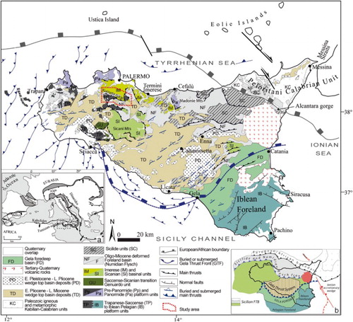
Figure 1. Geological–structural map of Sicily and adjacent offshore area (modified from CitationCatalano, Valenti, et al., 2013 with reference therein). The inset maps show (a) tectonic map of central Mediterranean area (foreland basins are shaded dark grey); and (b) main structural elements of the Sicilian chain.
The geological complexity of this sector has caused different authors to propose alternative interpretations about the cropping-out tectonic structure. CitationGhisetti and Vezzani (1984), CitationGiunta, Nigro, Renda, and Giorgianni (2000), CitationRenda, Tavarnelli, Tramutoli, and Gueguen (2000), CitationNigro and Renda (2001) interpreted the E-W-trending 20 km long main lineament along the Kumeta ridge as part of the southern boundary of a regional crustal shear zone in Sicily (Kumeta-Alcantara alignment), whose northern boundary should be the Ustica-Eolie line in the southern Tyrrhenian (CitationGueguen, Tavarnelli, Renda, & Tramutoli, 2010). CitationCatalano, Franchino, Merlini, and Sulli (2000) and CitationCatalano, Valenti, et al. (2013), based on seismic reflection profile analysis and field surveys, reconstructed the deep structural features in central-western Sicily down to the crystalline basement emphasizing the role exerted by the collision-related contractional events.
This paper describes the stratigraphic and structural settings of the area and the relationships among the distinct carbonate tectonic units, forming the main bulk of the chain. Furthermore, by integrating field data with seismostratigraphic interpretation, we attempt to correlate outcropping and buried contractional features to reconstruct the Tertiary compressional tectonic geometries. We also discuss the role of the strike-slip features with respect to the compressional structures in the studied sector of the Sicilian orogen.
2. Data and methods
The geological map of Kumeta-Pizzuta ridges, reproduced at 1:25,000 scale, is the result of geological surveys including stratigraphic and meso-structural analyses. In order to improve the geological information, we integrated the field data with the results of previous geological and geophysical surveys (CitationCatalano, Avellone, Basilone, & Sulli, 2010; CitationCatalano, Avellone, Basilone, Gasparo Morticelli, 2010; CitationAvellone, Basilone, 2013; CitationCatalano, Basilone, et al., 2013), performed in the framework of the CARG project (Italian official Geological Cartography; www.isprambiente.gov.it).
The geological mapping was accomplished through the following steps:
detailed geological field survey (at 1:10,000 scale) to collect stratigraphic and structural data in order to characterize the tectonic features and define the kinematic evolution. Good exposure and high lateral continuity of the outcropping successions have been the chosen criteria to select the sites of structural measurements.
stratigraphic analysis, aimed at describing the geometry and lateral to vertical evolution of the lithostratigraphic sequences;
statistical fold and fault analysis, which allow definition of fault kinematics, fold-trending and stress-field orientations. The collected meso-structural data have been summarized in steroplots () using Daisy 3.0 (CitationSalvini, 2001).
The recognized tectonic units and their structural relationships are illustrated in the geological cross sections on the Main Map.
For a better lateral continuity of the outcrops, we mapped the inferred-lithostratigraphic units beneath urban areas using new confidential borehole data recently acquired from engineering projects.
The topographic basemap on the geological map is the Carta Tecnica Regionale (vector file format .dwg, plane coordinates referred to the East Zone of the Gauss-Boaga Italian national system projection, datum Roma 1940, Monte Mario) with a contour interval of 50 m. The drainage system has been simplified cleaning the first- and second-order tributaries. For better representation, the geological map has been draped on a shaded-relief map available for the area (http://map.sitr.regione.sicilia.it/ArcGIS/services/DTM_2m/MapServer/WMSServer).
3. Geological background
The Sicilian orogen (), located in the centre of the Mediterranean Sea at the NE corner of the Tunisian-Sicilian promontory (northern African continental margin, (a)), links the Southern Apennines and the Calabrian Arc to the Tellian and Atlas systems of North Africa ((a)).
The Sicilian FTB ((b)) is a complex stack of S- and SE-verging imbricates locally more than 15 km thick, whose building up is linked to both the post-collisional convergence between Africa and a complex ‘European’ crust (CitationBonardi, Cavazza, Perrone, & Rossi, 2001), and to the coeval roll-back of the subduction hinge of the Ionian lithosphere (CitationCatalano, Valenti, et al., 2013; CitationDoglioni, Gueguen, Harabaglia, & Mongelli, 1999 and references therein).
The Sicilian FTB is formed by Meso-Cenozoic deep-water carbonate and siliciclastic units, overriding a more than 10 km thick carbonate platform thrust wedge, detached from the crystalline basement (CitationCatalano, Valenti, et al., 2013) and covered by upper Miocene to middle Pleistocene clastics, pelagites and evaporites, which unconformably seal the whole underlying tectonic stack, filling thrust-top basins (CitationButler & Grasso, 1993; CitationGasparo Morticelli et al., 2015; CitationGugliotta et al., 2014; CitationNigro & Renda, 2000).
The study area is located in the southernmost edge of the Palermo Mts (; northernmost sector of the emerged Sicilian FTB). In this area, the tectonic edifice results from the piling-up of deep-water-, carbonate platform- and pelagic platform-derived tectonic units (Imerese and Sicilide, Panormide and Trapanese domains, respectively) originating from deformations of the former northern African continental margin (CitationCatalano et al., 2000).
The tectonic units, each one 900–1200 m, 2000–3000 m and 3500–5000 m thick, respectively, are stacked to form an S- and SW-verging thrust pile characterized by ramp and flat geometry. The distance between subsequent culminations of the structures (ramp anticlines or thrust fronts) is 4–6 km for the Imerese tectonic units (Event 1), and 9–12 km for the Trapanese tectonic units (Event 2). The Neogene deposits lying at the top of the footwall block, postdate the respective tectonic emplacement (CitationAbate, Catalano, & Renda, 1978).
The main build-up of the Sicilian tectonic edifice started in the early Miocene and resulted from the overthrusting of thin, deep-water, carbonate tectonic units (Imerese and Sicanian) above thick, more external, carbonate platform tectonic units (Panormide, Tranese-Saccense; ) in a general thin-skinned thrust tectonics (CitationRoure, Howell, Muller, & Moretti, 1990); recently, late thick-skinned thrust tectonics has been suggested (CitationCatalano, Valenti, et al., 2013; CitationGasparo Morticelli et al., 2015).
In the study area, where the structural relationships between Imerese and Trapanese tectonic units can be observed, two main subsequent tectonic events have been recognized:
– shallow-seated thrusting (tectonic Event 1) involved the Sicilide and Imerese rock units producing imbricate-fan and duplex geometry since Serravallian time (CitationCatalano et al., 2000; CitationNigro & Renda, 2001);
– during the latest Miocene – Early Pliocene the development of deep-seated thrusts detached and deformed the buried carbonate platform rocks (deep seated, tectonic Event 2), forming axial culminations and ramp structures (CitationAvellone, Gennaro, Gugliotta, Barchi, & Agate, 2011; CitationGugliotta et al., 2014; CitationGugliotta & Gasparo Morticelli, 2012). The wedging at depth of the carbonate platform substrate implied re-embrication and shortening into the overlying deep-water carbonate thrust pile (CitationAvellone, Barchi, Catalano, Gasparo Morticelli, & Sulli, 2010; CitationBello, Franchino, & Merlini, 2000; CitationCatalano et al., 2000).
The resulting tectonic structures are not coaxials and their present-day setting can be explained by the occurrence of progressive, vertical-axis clockwise rotations during their emplacement (CitationOldow, Channell, Catalano, & D’Argenio, 1990; CitationSperanza, Maniscalco, & Grasso, 2003). The rotation amount decreases stepwise from internal to external tectonic units and the high value of rotation measured in the internal tectonic unit (e.g. Imesere tectonic unit) comes from adding the contribution of distinct rotation stages during forward orogenic propagation.
4. Stratigraphy and facies analysis
The lithostratigraphic units recognized in the study area pertain to the well-known facies domain of the Sicilian sector of the African continental margin (CitationCatalano & D’Argenio, 1978).
The Sicilide unit is composed of mainly pelagic shale, marls and limestone (Varicoloured clays and Polizzi fm, the AVF and POZ in the Main Map, respectively) detached from their substrate.
The Numidian succession is mainly composed by turbidites (Numidian flysch, FYN) separated into two distinct members Late Oligocene-Early Miocene in age, followed by Burdigalian-Langhian marls and shales interlayered with a mega-bank of siliceous sandstones rich in glauconite (Tavernola fm., TAV).
The Imerese slope-to-basin succession (stratigraphic columns on Main Map), spanning from the middle Carnian to the early Miocene, is composed of carbonate and silico-carbonate pelagites interbedded with cyclically arranged carbonate platform-derived resedimented deposits (CitationBasilone, Frixa, Trincianti, & Valenti, 2016 and references therein).
The Trapanese pelagic platform succession (stratigraphic columns on Main Map) is made up of Lower Jurassic shallow-water limestone, unconformably followed by Jurassic-Eocene carbonate pelagites and Burdigalian-to-lower Tortonian clastic carbonates and outer shelf marls.
These units are unconformably covered by upper Miocene clastic and terrigenous rocks (Castellana and Terravecchia Fms, SIC and TRV, respectively), filling syn-tectonic sedimentary basins (CitationGugliotta et al., 2014), and by Quaternary continental deposits.
A complete description of the sedimentary succession is reported in the legend of the Main Map.
5. Tectonic features
The geological–structural surveys allowed better constraint of the deformational pattern and the lateral continuity of the structures, and to age-date the wedging of the Imerese above the Trapanese tectonic units. These units are superimposed along a main thrust, whose cut-off line outcrops at M. Leardo. Here the Upper Triassic cherty limestone of the Imerese unit tectonically overlaps the Upper Cretaceous pelagic limestone of the Trapanese unit.
As a consequence of the compressive deformation that duplicates the Imerese succession, we can distinguish three stacked thrust sheets, each one forming a minor tectonic unit topped by Numidian flysch deposits. From the top of the wedge, we distinguished Gradara, Pizzuta and Leardo tectonic units, respectively. Conversely, the Kumeta tectonic unit is formed by Trapanese pelagic platform succession on the whole that does not show duplication on outcrop.
The meso-structural data (–) collected at 28 sites () provided the kinematics of the tectonic structures (). We have classified three-fold systems with different age and trends, here named h1, h2, h3.
Figure 2. Shaded relief of the study, indicating the main structural elements, the sites of the structural measurement and the maximum horizontal stress orientation (SHmax) for both Events 1 and 2 (modified from CitationAvellone et al., 2010; CitationGasparo Morticelli, 2008).
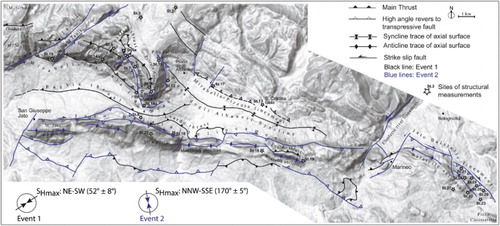
Table 1. Stereographic projection of the structural data collected in the study area.
Table 2. Structural data related to fault planes.
Table 3. Structural data related to minor fold with associated pressure solution axial plane cleavages and extensional veins.
Table 4. Main tectonic structures.
In the following, we will describe the most relevant tectonic features and outcrop location of these tectonic units.
5.1. Imerese tectonic units
5.1.1. Gradara tectonic unit
A small portion of this unit crops-out in the NW corner of the investigated area (Structural map on Main Map) where it forms a north-east dipping monocline tectonically overriding the Pizzuta tectonic unit along a WNW-ESE-oriented thrust (Gradara thrust in ). This thrust is shifted towards the SE by a right-lateral fault. To the east, the Gradara tectonic unit is bounded by a main NE-SW-oriented left-lateral fault (Cannavera Fault in ).
5.1.2. Pizzuta tectonic unit
In this widely extended unit, cropping-out along the northern sector of the area (Structural map on Main Map), three main large-scale folds can be recognized ():
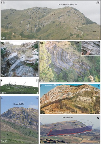
the WNW-ESE-trending Mirabella anticline (h1-system), located in the north-western sector of the map, at the hanging wall of the Mirabella-Pizzuta lineament, with a wavelength of hundreds of metres. At the core, the Mufara Fm. outcrops, while the Scillato Fm. forms the flanks at Pizzo della Nespola and Mt. Matassaro Renna ((a)). The outer flank is overturned along the southern slope of Pizzo Mirabella (Main Map);
the N-S-trending Pizzuta anticline (h3-system) crops-out between Serre del Frassino and Portella del Garrone, characterized by two hinge zones: (i) N-S to NNE-SSW oriented with E-vergence along the Garrone-Pizzuta ridge, and (ii) NNW-SSE oriented with WSW-vergence along Serre del Frassino ((b,c)). Toward the S, the Pizzuta anticline is abruptly interrupted along an SSE-dipping backthrust. Above the latter fault, a ENE-WSW-trending anticline occurs (Maja e Pelavet anticline in ; h2-system). The structural analysis (see ) reveals that the Imerese succession is affected by the NE-SW-trending h2-fold system (see also CitationAvellone & Barchi, 2003).
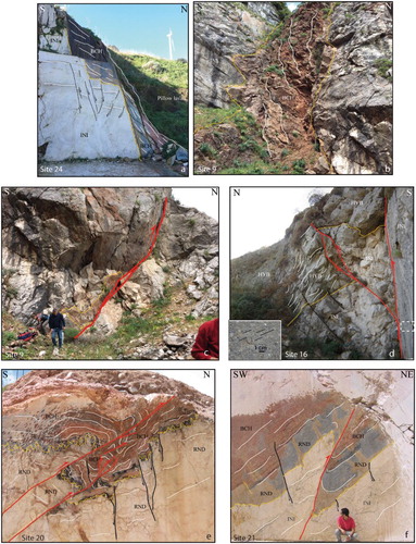
Figure 3. Main folds outcropping in the study area (blue lines represent the deformed strata): (a) panoramic view of NW-SE-trending hinge zone of the Mirabella anticline shaping the Upper Triassic Imerese succession (SCT and MUF) that crop-out close to M. Matassaro Renna; (b) asymmetrical NW-SE-trending minor folds of the main Pizzuta anticline characterized by high-angle hinge-plunging; (c) cylindrical NW-SE-trending folds (Pizzuta Anticline) with a few tens of metres wavelength that involve the Upper Triassic Imerese succession (SCT). The scarp represents a left-transpressive fault-plane (Chiusa fault) related to the tectonic Event 2; Inset 1 shows detail of the striated fault plane; (d) N-vergent WNW-ESE-trending syncline that deformed the Upper Oligocene resedimented calcarenites of the Numidian Flysch; northern slope of M. Kumeta; (e) panoramic view of the E-W-trending Maganoce anticline that involve the Cretaceous marls and calcilutites of the Trapanese succession (HYB and AMM); (f) panoramic view of the S-verging E-W-trending Rossella anticline; (g) panoramic view of the NW-SE-trending Balatelle anticline (the dotted lines indicate the trajectory of the supposed hinge zone) that grow above a SW-dipping right-lateral transpressive fault (Jato-Balatelle lineament).
This feature displays a complex tectonic style due to the interference of two folding events. In detail, the superimposition of the h2-fold system on the h1-fold-system produces type 1 and 2 interference patterns () (sensu CitationRamsay & Huber, 1987) and locally rotation of the h1-fold system along the N-S-trend (CitationAvellone et al., 2010; CitationGasparo Morticelli, 2008).
Figure 4. Cross-cutting relationships between deformation features that affected the Imerese tectonic units: (a,b) hinge and limb tracers, respectively, of a fold where cross-cutting relationship between two pressure solution-cleavage and extensional vein systems occur (C-V system; St. 6 in and ; see for ubication); (c) fold systems and related interpretative sketch showing type 2 fold interference pattern (sensu CitationRamsay & Huber, 1987).
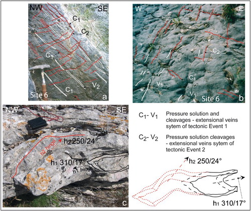
We also recognized two sets of pressure solution cleavages (C1 and C2 in ), with extensional veins (V1 and V2 in ). In agreement with the relative chronology indicated by the interference figures, the cross-cutting relationships indicate that C1-V1 is older than C2-V2 ().
The Piana degli Albanesi syncline (h1-system) extends in a wide sag between the M. Pizzuta and M. Kumeta ridges, where the Numidian flysch deposits crop out (Main Map); the syncline axis shows a bended trend varying from NW-SE to W-E.
The Pizzuta tectonic unit is affected by some main fault systems (; Main Map):
the WNW-ESE-trending Mirabella-Pizzuta lineament, which represents a main morphostructural element about 24 km long, bounds the southern edge of the Pizzuta tectonic unit. From M. Dammusi to Cozzo Fratantoni (western sector of the lineament), local overturned bedding and striated fault planes suggest displacement along a reverse fault with NNE-dip and 70° slope (stereonet in ; cross section A-A’ in Main Map). In the central sector of the lineament (M. Maja e Pelavet), a left-lateral transpressive NE-SW-trending fault occurs (Stereonet in ; cross sections B-B’ in Main Map). Between Piana degli Albanesi and Pietra del Corvo, the lineament represents the thrust of the Pizzuta tectonic unit above the Leardo tectonic unit (cross sections C-C’ in Main Map). The internal imbrication of the Imerese succession is well observable close to Portella della Paglia (Main Map) where the Mufara and Scillato Fms are tectonically superimposed over the Numidian Flysch (Paglia thrust in ). This thrust is also inferred as being buried in the sector between the Pizzuta and Kumeta ridges ().
strike-slip and transpressive faults, with offset of a few kilometres, displacing the Mirabella-Pizzuta lineament (): the NW-dipping Cannavera left-lateral strike-slip-fault shifts towards the SW edge of the Pizzuta tectonic unit; the NE-SW-oriented Monte Dammusi strike-slip fault has a quasi-vertical dip and displays offsets of about 600 m; the Serre del Frassino fault is about 80° ENE dipping right-lateral transpressive fault that cuts and shifts 1000 m SE towards the Mirabella-Pizzuta lineament; the NE-SW-oriented Chiusa left-lateral strike-slip fault displays a high-angle NW-dipping plane ((c)); the NNE-SSW-trending left-lateral strike-slip fault that displaces the Mirabella-Pizzuta lineament in the eastern sector of the map.
In the northeastern sector, the Pizzuta tectonic unit forms a large SW-dipping monocline interpreted as the forelimb of a ramp anticline (CitationAvellone et al., 2010; CitationBarreca, Maesano, & Carbone, 2010). This monocline is affected by reverse faults with SW and NE tectonic transport direction, left-lateral strike-slip NE-SW-trending faults, SW- and SE-verging minor folds, and NW-SE-trending normal faults. As concerns these latter faults, we observed that the Jurassic interval of the hangingwall succession displays a thickness higher than the coeval footwall succession. These features highlight Mesozoic syn-sedimentary extensional tectonics that affect the Imerese succession. Along the Eleuterio River valley, an NE-SW-trending left-lateral strike-slip fault (Eleuterio lineament in ) breaks off the monocline, bounding the Pizzuta tectonic unit eastward.
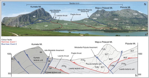
Figure 5. (a) Panoramic view of the Kumeta Mt. (left side) and the Pizzuta Mt. (right side) where the Trapanese and Imerese successions, respectively, outcrop. The thrust of the Imerese tectonic unit over the Trapanese unit crops-out between Kumeta and Maja e Pelavet Mts. The main tectonic structures are shown (black and blue lines, Event 1 and Event 2, respectively). (b) Geological cross-section along the skyline of picture in (a).
5.1.3. Leardo tectonic unit
It crops out along an E-W-trending belt from the Piana degli Albanesi lake up to Marineo village, and at Pizzo Chiarastella. It overrides the Trapanese tectonic unit along the WNW-ESE-trending Leardo thrust (see structural map and and ) with an SW tectonic transport. Minor NW-SE-oriented transpressive faults offset locally this thrust front. The Leardo thrusting postdates the Marne di S. Cipirello Fm (late Serravallian-early Tortonian), which crops out in a tectonic window SW of Marineo.
Along the northern slope of M. Leardo, the tectonic unit is bounded by a transpressive right-lateral fault (Jato-Balatelle lineament in and cross section C-C’ in Main Map). At Pizzo Chiarastella, the Leardo tectonic unit crops out in an NW-SE-trending anticline bounded by right-lateral transpressive faults pertaining to the E-W Jato-Balatelle lineament (here NW-SE-trending).
Regarding the whole Imerese tectonic unit, cross-cutting relationships revealed that the h2-system as well as the NW-SE and NE-SW transpressive fault planes postdate the h1-system and the NW-SE thrust. The h3-system results from the interference between the h1- and h2-systems.
5.2. Trapanese tectonic units
The Trapanese tectonic unit outcrops along the E-W-trending Kumeta ridge from M. Jato (West) to M. Balatelle (East). Seismic reflection data show that the Kumeta tectonic unit is up to 3000 m thick (CitationAvellone et al., 2010). The Kumeta ridge forms a main structural high, bounded toward the N by the S-dipping transpressive Jato-Balatelle lineament ( and (c,d)). Along the ridge, we identified the main E-W-trending and S-verging anticlines at M. Jato, M. Maganoce and M. Rossella ( and (e,f)). Close to the eastern end of the ridge, the anticline axis, as well as the transpressive faults, turn taking on a NW-SE trend (Balatelle anticline; and (g)). The meso-structural data collected along the Kumeta tectonic unit (–) revealed three main minor-fold systems: (i) E-W-trending S-vergent folds (h1-system); (ii) NE-SW-trending symmetric folds (h2-system); (iii) NW-SE-trending SW-vergent folds (h3-system).
Figure 6. Main faults outcropping in the study area. (a) Mesozoic normal fault (black line) affecting the Liassic shallow-water carbonate platform (Trapanese succession; M. Balatelle); (b) Neptunian dyke affecting the Early Jurassic limestone (INI) filled by Middle Jurassic red nodular limestone (BCH), northern slope of the M. Kumeta; (c) S-dipping transpressive fault (Jato-Balatelle lineament) affecting the Inici Fm. and Upper Jurassic – Lower Cretaceous deposits filling Neptunian dykes (BCH and HYB; northern slope of the M. Kumeta); (d) normal faults (black lines) recognized along the Jato-Balatelle lineament (red lines) that affect the Lower Cretaceous calcilutites and marls (HYB); the faults as well as the stratigraphic surface (dashed yellow line) appear tilted as a consequence of the subsequent transpressive faults (Jato-Balatelle lineament); (e, f) compressive structures (S-dipping thrusts and ramp anticlines, red lines) affecting the Jurassic carbonate Trapanese succession (INI, BCH and RND) of M. Kumeta and M. Balatelle, respectively. The Trapanese succession has been displaced by previous (Jurassic) normal faults (black lines).
The Jato-Balatelle lineament () represents the main cropping-out backthrust ((c,d)), along which the Trapanese tectonic unit is exhumed, overriding the marls of the S. Cipirello Fm and the Numidian flysch deposits (cross sections on Main Map). This backthrusting is accompanied by minor S-dipping (synthetic) thrusts ((e,f)), high-angle N-dipping (antithetic) E-W-oriented transpressive faults and N-vergent asymmetric E-W-trending folds ((d)).
The Kumeta ridge uplift induced exhumation of the Leardo thrust (cross section C-C’ on Main Map).
Minor faults occur, showing different trends: E-W and NW-SE right-lateral strike-slip faults (synthetic faults) and NNE-SSW left-lateral strike-slip fault (antithetic faults). Cross-cutting relationships reveal the conjugate strike-slip to transpressive faults (NW-SE and NE-SW-oriented) cut and locally rotate the main Jato, Maganoce and Balatelle anticlines (Main Map).
The Trapanese succession is affected by syn-sedimentary WNW-ESE-oriented neptunian dykes and normal faults: extensional fractures filled by Middle Jurassic-Upper Cretaceous pelagites (CitationDi Stefano, Galacz, Mallarino, Mindszenty, & Voros, 2002; (b)); normal syn-sedimentary faults (Middle Jurassic in age; (a)), forming grabens and half-grabens and favouring the ascent of basaltic pillow in the Mt. Balatelle area (CitationBasilone, Gasparo Morticelli, & Lena, 2010; CitationGasparo Morticelli & Lena, 2008).
5.2.1. Seismic reflection data
The interpretations of the seismic reflection profiles, crossing the Kumeta ridge (NW-SE and N-S striking), reveal the deep geometry of the tectonic stack ((c)), allowing the fault systems, already recognized by field work, to be correlated down to the deep base of the tectonic units.
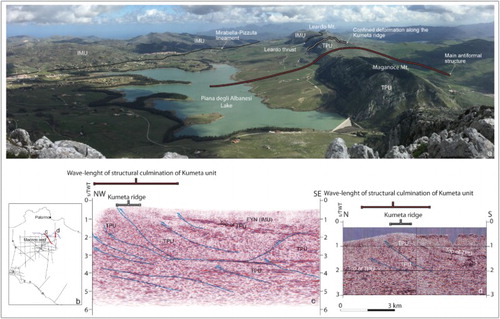
Figure 7. (a) Panoramic view of the eastern sector of the study area. On the right side, the Kumeta ridge and on the left side the main outcrop of the Imerese succession. In this area, we can observe the structural relationships between the Imerese and Trapanese tectonic units (IMU and TPU, respectively). On the central-left side, we drew the Mirabella-Pizzuta lineament along which the Pizzuta tectonic unit overrides the Leardo tectonic unit. From this observation point, we can depict the geometry of the bending coming from the Trapanese units thrusting and uplifting: the red line depicts the wavelength of folds involving the buried carbonate platform succession; otherwise, the white line outlines the shorter wavelength folding which characterize the Kumeta ridge. Interpreted seismic reflection profiles (traces in b) across the central (c) and the eastern (d) sectors of the Kumeta ridge (modified from CitationCatalano et al., 2000).
The high-angle, S-ward dipping transpressive fault, bounding N-wards the Kumeta ridge (Jato-Balatelle lineament), belongs to the thrust system imaged in the seismic sections of , whose geometries have been highlighted through the displacement and tilting of the seismic horizons attributed to the Trapanese succession. The divergent horizons of the lower portion of the Trapanese succession correspond to the contact between the low-angle ramp and the flat thrust, pointing out, the progressive decreasing of the thrust-dip at depth. At a depth of 4 s/TWT, the thrust planes flatten ((c)), clearly showing that the thrusting propagated following sedimentary packages not involving the deep crustal layers.
By comparing the geometries coming from the seismic interpretation with the present morphostructural setting ((a)), the arching of the Kumeta tectonic unit can be noted as having a wavelength larger than that one imaged by the outcropping ridge.
The seismic profiles ((c)) indicate that the Jato-Balatelle lineament is not the actual northern boundary of the Kumeta tectonic unit which can be recognized up to some kilometres N-ward, where it is buried beneath the Imerese tectonic units (see cross sections on Main Map).
6. Discussion and conclusion
Since the pioneering insight of CitationRuggieri (1966), many authors shared the idea the Kumeta Ridge was a rock body exhumed along prominent strike-slip faults. Indisputably, a lot of meso-structural data reveal strike-slip tectonic features that have contributed to build up the Kumeta Ridge. But do these transcurrent structures reflect an extensive, regional stress field or are they only minor secondary features?
All the authors (see the list below) agree that the shortening which affected this area during the Neogene occurred following two subsequent tectonic events: the former (middle-late Miocene) is responsible for the thrusting of the Imerese tectonic units over the Trapanese succession; the latter induced the Trapanese units to be folded, faulted and uplifted.
Except for CitationGiunta (1991), who suggests a possibility that the orogenic process in the whole area developed in a transpressive mode, the interpretation that the first event is related to continental collision between the Sardinian Block and the northern African continental margin has been largely accepted. Whereas, two different explanations for the origin of the later deformational stage have been suggested.
According to CitationGhisetti and Vezzani (1981, Citation1984), the Kumeta Ridge is a segment of a main tectonic lineament, the Kumeta-Alcantara fault system, crossing through the whole of northern Sicily. The authors interpreted this fault system as the main surface branch of a major crustal shear zone located between northern Sicily and the southern Tyrrhenian.
Other authors (CitationFinetti, Lentini, Carbone, Catalano, & Del Ben, 1996; CitationGiunta et al., 2000; CitationNigro & Renda, 1999) confirm the deep crustal character of the Kumeta-Alcantara fault system, speculating about a major shear zone along the southern Tyrrhenian margin bounded by the Ustica-Eolie line to the north and the Kumeta-Alcantara line to the south.
Our detailed geological and structural surveys, integrated with seismic reflection profiles, show that the buried, a few thousands metres thick, Trapanese unit has been deformed and displaced by an S-dipping thrust system subsequent to the former overthrusting of the Imerese tectonic units (see also CitationAvellone et al., 2010; CitationBarreca et al., 2010; CitationBarreca & Maesano, 2012; CitationCatalano et al., 2000); the latter developed with an S and SW tectonic transport direction (Event 1). The wedging at depth of the Trapanese units (Event 2), implying passive deformations of the already deformed overlying Imerese tectonic units, produced main (higher wavelength) anticline culmination, outcropping along the Kumeta Ridge (see schematic model on Main Map). The structural data collected in the Imerese tectonic units (; –) also highlight that the reconstructed stress-field orientation related to Cannavera, Dammusi, Serre del Frassino and Chiusa faults is associated with tectonic Event 2.
Seismic reflection profiles show the main E-W-trending anticlines have been offset by high-angle reverse to transpressive faults that merge at depth with low-angle, regionally widespread, flat decollement surfaces that in this sector show an N-directed tectonic transport.
In the seismic sections, the Kumeta tectonic unit dips S-ward ((c)), highlighting an enhanced asymmetry, not in agreement with characteristic strike-slip-fault structures, as previously suggested by the authors that described the so-called Kumeta-Alcantara line.
The displacement associated with the fault system imaged in the seismic sections (), accounted for the almost 2 km uplift of the Kumeta tectonic unit, while tectonic transport along the main thrust is N-ward-directed. These features support a backthrusting along a transpressional fault in the Kumeta region, while meso-structural field data document that the minor-fold-vergence is S-directed.
Our field data, according to the previously mentioned authors, support that the main E-W-oriented high-angle faults bordering the Kumeta ridge display a dominant transpressive offset. Moreover, as illustrated before, a lot of Mesozoic normal faults and neptunian dykes ((a,b)), trending parallel to the carbonate ridge, have been detected in this sector. Normal faults produced small intra-platform basins (CitationBasilone et al., 2010) that were, often, reactivated by transpressive faults (CitationAvellone et al., 2010). Thus, also taking into account the large-scale, sin-kinematic, clockwise rotations involving the thrusts during their emplacement (CitationOldow et al., 1990), the transpressive reactivation during the post-Tortonian shortening is compatible with the orientation of the syn-sedimentary (Mesozoic) normal faults (see also CitationAvellone et al., 2010, p. 115).
According to the structural pattern here depicted, we assess the Kumeta ridge represents only an exhumed (by transpressive to reverse faults related to tectonic Event 2), narrow slice of a wider N-vergent tectonic unit, derived from deformation of the buried Trapanese carbonate platform () and the already thrusted Imerese tectonic units. As a whole, this structural setting rules out the Kumeta ridge as a positive flower structure related to a deep crustal shear zone as formerly suggested.
Software
The map was produced using Esri ArcGIS and Global Mapper. The geo-referenced data-files were then modified using Adobe Illustrator. Daisy 2.0 was used to produce the stereonet plots (CitationSalvini, 2001).
Mountain building in NW Sicily from the superimposition of subsequent thrusting and folding events during Neogene: structural setting and tectonic evolution of the Kumeta and Pizzuta Ridges.pdf
Download PDF (76.8 MB)Acknowledgements
We wish to thank V. Tieppo Meira, G. Barreca and J. Cron for useful reviews of the manuscript.
Disclosure statement
No potential conflict of interest was reported by the authors.
ORCID
M. Gasparo Morticelli http://orcid.org/0000-0002-9966-6800
A. Sulli http://orcid.org/0000-0002-7705-3632
M. Agate http://orcid.org/0000-0002-9861-7601
L. Basilone http://orcid.org/0000-0002-2719-2984
R. Catalano http://orcid.org/0000-0002-1554-062X
Related Research Data
References
- Abate, B., Catalano, R., & Renda, P. (1978). Schema geologico dei Monti di Palermo (Sicilia). Bollettino Della Società Geologica Italiana, 97, 807–819.
- Avellone, G., & Barchi, M.R. (2003). Le pieghe minori nelle Unita Imeresi e Trapanesi dei Monti di Palermo e il loro significato nell’evoluzione tettonica dell’area. Bollettino della Società Geologica Italiana, 122, 277–294.
- Avellone, G., Barchi, M. R., Catalano, R., Gasparo Morticelli, M., & Sulli, A. (2010). Interference between shallow and deep-seated structures in the Sicilian fold and thrust belt, Italy. Journal of the Geological Society, 167, 109–126.
- Avellone, G., Gennaro, C., Gugliotta, C., Barchi, M. R., & Agate, M. (2011). Tectono-stratigraphic evolution of a basin generated by transpression: The case of the early Pliocene Lascari Basin (Northern Sicily). Italian Journal of Geosciences, 130, 93–105.
- Barreca, G., & Maesano, F. E. (2012). Restraining stepover deformation superimposed on a previous fold-and-thrust-belt: A case study from the Mt. Kumeta-Rocca Busambra ridges (Western Sicily, Italy). Journal of Geodynamics, 55, 1–17.
- Barreca, G., Maesano, F. E., & Carbone, S. (2010). Tectonic evolution of the Northern Sicanian-Southern Palermo mountains range in Western Sicily: Insight on the exhumation of the thrust involved foreland domains. Italian Journal of Geoscience (Bollettino Della Società Geologica Italiana), 129(3), 429–440.
- Basilone, L., Frixa, A., Trincianti, E., & Valenti, V. (2016). Permian–cenozoic deep-water carbonate rocks of the Southern Tethyan domain. The case of central Sicily. Italian Journal of Geosciences, 135(1). doi:10.3301/IJG.2015.07
- Basilone, L., Gasparo Morticelli, M., & Lena, G. (2010). Mesozoic tectonics and volcanism from Tethyan rifted continental margins in Western Sicily. Sedimentary Geology, 226, 54–70. doi:10.1016/j.sedgeo.2010.02.009
- Bello, M., Franchino, A., & Merlini, S. (2000). Structural model of Eastern Sicily. Memorie Della Società Geologica Italiana, 55, 61–70.
- Bonardi, G., Cavazza, W., Perrone, V., & Rossi, S. (2001). Calabria-peloritani terrane and Northern Ionian Sea. In G. B. Vai & I. P. Martini (Eds.), Anatomy of an orogen: The Apennines and adjacent Mediterranean basins (pp. 287–306). Dordrecht: Kluwer Academic.
- Butler, R. W. H., & Grasso, M. (1993). Tectonic control on base level variations and depositional sequences within thrust-top and foredeep basins: Examples from the neogene thrust belt of central Sicily. Basin Research, 5, 137–151.
- Catalano, R., Avellone, G., Basilone, L., Contino, A., Agate, M., Di Maggio, C., … Lo Cicero, G. (2013). Carta geologica d’Italia alla scala 1:50.000 e note illustrative del foglio 595 Palermo. ISPRA, Servizio Geologico d’Italia, Roma: SystemCard, 1–218.
- Catalano, R., Avellone, G., Basilone, L., Gasparo Morticelli, M., & Lo Cicero, G. (2010). Note illustrative della Carta Geologica d’Italia alla scala 1:50.000. Foglio 608 “Caccamo” e carta geologica allegata. ISPRA, Servizio Geologico d’Italia, Roma.
- Catalano, R., Avellone, G., Basilone, L., & Sulli, A. (2010). Note illustrative della Carta Geologica d’Italia alla scala 1:50.000. Foglio 607 “Corleone” e carta geologica allegata. ISPRA, Servizio Geologico d’Italia, Roma.
- Catalano, R., Basilone, L., Di Maggio, C., Gasparo Morticelli, M., Agate, M., & Avellone, G. (2013). Carta geologica d’Italia alla scala 1:50.000 e note illustrative del foglio 594–585 Partinico-Mondello. ISPRA, Servizio Geologico d’Italia, ROMA: System Cart, 1–270.
- Catalano, R., & D’Argenio, B. (1978). An essay of palinspastic restoration across Western Sicily. Geologica Romana, 17, 145–159.
- Catalano, R., Franchino, A., Merlini, S., & Sulli, A. (2000). Central western Sicily structural setting interpreted from seismic reflection profiles. Memorie Società Geologica Italiana, 55, 5–16.
- Catalano, R., Valenti, V., Albanese, C., Accaino, F., Sulli, A., Tinivella, U., … Giustiniani, M. (2013). Sicily’s fold/thrust belt and slab rollback: The SI.RI.PRO. Seismic crustal transect. Journal of the Geological Society, 170, 451–464.
- Di Stefano, P., Galacz, A., Mallarino, G., Mindszenty, A., & Voros, A. (2002). Birth and early evolution of a Jurassic escarpment: Monte Kumeta, Western Sicily. Facies, 46, 273–298.
- Doglioni, C., Gueguen, E., Harabaglia, P., & Mongelli, F. (1999). On the origin of west-directed subduction zones and applications to the Western Mediterranean. In B. Durand, L. Jolivet, F. Horvath, & M. Séranne (Eds.), The Mediterranean basins: Tertiary extension within the alpine orogen. – Geol. Soc. (vol. 156, pp. 541–561). Palermo:London: Sp. Publ.
- Finetti, I., Lentini, F., Carbone, S., Catalano, S., & Del Ben, A. (1996). Il sistema Appennino meridionale–Arco Calabro–Sicilia nel Mediterraneo centrale: studio geologico–geofisico. Bollettino Società Geologica Italiana, 115, 529–559.
- Gasparo Morticelli, M. (2008). Le unità tettoniche della catena nella Sicilia centro occiidentale. Evoluzione cinematica (Unpublished doctoral dissertation). Palermo: University of Palermo.
- Gasparo Morticelli, M., & Lena, G. (2008). Successioni vulcano-sedimentarie in aree di Piattaforma Carbonatica: l’esempio di Vicari e M. Balatelle (Sicilia NW). Rendiconti online Soc. Geol. It., Vol. 3. pp. 411–412. In G. Oggiano, L. Carminati, A. Funedda, & P. Conti (Ed.) 84° Congresso Nazionale, Sassari 15–17 settembre 2008.
- Gasparo Morticelli, M., Valenti, V., Catalano, R., Sulli, A., Agate, M., Avellone, G., … Gugliotta, C. (2015). Deep controls on foreland basin system evolution along the Sicilian fold and thrust belt. Bulletin de la Société Géologique de France, 186(4–5), 273–290.
- Ghisetti, F., & Vezzani, L. (1981). Contribution of structural analysis to understanding the geodynamic evolution of the Calabrian arc (Southern Italy). Journal of Structural Geology, 3(4), 371–381.
- Ghisetti, F., & Vezzani, L. (1984). Thin-skinned deformations of the western Sicily thrust belt and relationships with crustal shortening: Mesostructural data on the Mt. Kumeta–Alcantara fault zone and related structures. Bollettino Società Geologica Italiana, 103, 129–157.
- Giunta, G. (1991). Elementi per un modello cinematico delle Maghrebidi Siciliane. Memorie Della Società Geologica Italiana, 47, 297–311.
- Giunta, G., Nigro, F., Renda, P., & Giorgianni, A. (2000). The Sicilian-Maghrebides Tyrrhenian margin: A neotectonic evolutionary model. Bollettino Della Società Geologica Italiana, 119, 553–565.
- Gueguen, E., Tavarnelli, E., Renda, P., & Tramutoli, M. (2010). The southern Tyrrhenian Sea margin: An example of lithospheric scale strike-slip duplex. Italian Journal of Geoscience, 129(3), 496–505.
- Gugliotta, C., & Gasparo Morticelli, M. (2012). Using high-resolution stratigraphy and structural analysis to constrain polyphase tectonics in wedge-top basins: Inferences from the late Tortonian Scillato Basin (central-northern Sicily). Sedimentary Geology, 273–274, 30–47.
- Gugliotta, C., Gasparo Morticelli, M., Avellone, G., Agate, M., Barchi, M. R., Albanese, C., … Catalano, R. (2014). Middle Miocene – early Pliocene wedge-top basins of North-Western Sicily (Italy). Constraints for the tectonic evolution of a “non-conventional” thrust belt, affected by transpression. Journal of the Geological Society, 171, 211–226.
- Nigro, F., & Renda, P. (1999). Evoluzione geologica ed assetto strutturale della sicilia centro settentrionale. Bollettino Della Società Geologica Italiana, 118, 375–388.
- Nigro, F., & Renda, P. (2000). Un modello di evoluzione tettono-sedimentaria dell’avanfossa neogenica siciliana. Bollettino Della Società Geologica Italiana, 119, 1913–1930.
- Nigro, F., & Renda, P. (2001). From mesozoic extension to tertiary collision: Deformation patterns in the northern Sicily chain units. Bollettino Della Società Geologica Italiana, 121, 87–97.
- Oldow, J. S., Channell, J. E. T., Catalano, R., & D’Argenio, B. (1990). Contemporaneous thrusting and large-scale rotations in the western Sicilian fold and thrust belt. Tectonics, 9, 661–681.
- Ramsay, J. G., & Huber, M. I. (1987). The techniques of modern structural geology, volume II: Folds and fractures. London: Academic Press.
- Renda, P., Tavarnelli, E., Tramutoli, M., & Gueguen, E. (2000). Neogene deformations of Northern Sicily, and their implications for the geodynamics of the Southern Tyrrhenian Sea margin. Memorie Società Geologica Italiana, 55, 53–59.
- Roure, F., Howell, D. G., Muller, C., & Moretti, I. (1990). Late cenozoic subduction complex of Sicily. Journal of Structural Geology, 12, 259–266.
- Ruggieri, G. (1966). Primi risultati di ricerche sulla tettonica della sicilia occidentale. Geologica Romana, 5, 453–456.
- Salvini, F. (2001). Daisy 2, version 2.44b. The structural Data Integrated Analyzer (free software computer program). Dipartimento di Scienze Geologiche, Università degli Studi di"Roma3”, Rome, Italy.
- Speranza, F., Maniscalco, R., & Grasso, M. (2003). Pattern of orogenic rotations in central–eastern Sicily: Implications for the timing of spreading in the Tyrrhenian Sea. Journal of the Geological Society, 160, 183–195.
- Strasser, A., Heitzmann, P., Jordan, P., Stapfer, A., Stürm B. Vogel, A., & Weidmann, M. (1995). Géo-topes et la pro-tection des objets géologiques en Suisse: un rapport stratégique. Fribourg: Groupe suisse pour la protection des géotopes. 27 p.
- Vogel, A., & Weidmann, M. (1995). Géo-topes et la pro-tection des objets géologiques en Suisse: un rapport stratégique. Fribourg: Groupe suisse pour la protection des géotopes. 27 p.