
ABSTRACT
The geological map of Piemonte Region (Italy) is a graphic representation of the geology of the region, grounded on a large geodatabase, that can be also browsed as an interactive scalable map (GeoPiemonte Map) using a WebGIS application. The Map, produced at 1:250,000 scale, is the first original release of the ‘GeoPiemonte Map’ project. The geological data represented on the map derive from a thorough revision of available geological maps and literature, integrated with unpublished original data. The revision and harmonisation of existing and new data have been based on explicit criteria used for the classification of geologic units and their representation on the Map. These criteria firstly aimed at providing a lithostratigraphic, hierarchic subdivision of Piemonte geologic units and describing them using shared concepts and vocabularies, consistent with IUGS Descriptive Standards for the Geosciences.
1. Introduction
The geological map of Piemonte (Italy) is a graphic representation of the geology of the region, grounded on the contents of a large geodatabase, that can be also browsed as an interactive scalable map, using a WebGIS application.
The Map, here published at 1:250,000 scale, is the first original release of the ‘GeoPiemonte Map’ project. It includes, as a supplementary file, a graphical Map Legend featuring a conceptual scheme showing the classification criteria used and a list of the consulted geological maps.
The production of the ‘GeoPiemonte Map’ was carried out by a Scientific Board consisting of researchers of CNR-IGG Torino (http://www.igg.cnr.it/), ARPA Piemonte (http://www.arpa.piemonte.gov.it/), DST, University of Torino and DIATI, Polytechnic University, Torino.
2. Methods
The Piemonte Geological Map is drawn at 1:250,000 scale and covers an area of approximately 25,400 km2. Geological data derive from a thorough revision of official and unofficial geological maps, which have been integrated with unpublished original data. Data were stored in a geographical information system (GIS) database and represented on a vector topographic basemap (Coordinate System WGS 1984 UTM, Zone 32N), prepared by Arpa Piemonte modifying the vector ‘Multiscale, Cross-borders Topographic Base’ (http://webgis.arpa.piemonte.it).
The Piemonte Geological Map consists of a GIS Map and Geodatabase compiled to represent the Alps–Apennines orogenic system. The available data were, in some cases, reinterpreted in order to fit the adopted classification scheme.
2.1. Map database – adopted controlled vocabulary and descriptive standards
The Piemonte Geological Map is semantically constrained by controlled vocabularies and a dedicated ontology (CitationLombardo et al., 2016 Ontogeonous, https://www.di.unito.it/wikigeo/index.php?title=Pagina_principale).
The Map adopted, at least for the main subdivisions of the Legend, the IUGS GeoSciML vocabularies (http://www.geosciml.org) compliant with the INSPIRE EU Directive (Data Specification on Geology v.3). The GeoSciML ‘Geologic Unit’ Taxonomy was chosen to establish the hierarchy of the geological subdivisions, while GeoSciML ‘Earth Material’ and ‘Rock Material’ Taxonomy was used for the lithological description of the Mapped Features. The geological discontinuities were classified following the GeoSciML ‘Contact’ and ‘Geologic Structure’ Taxonomy.
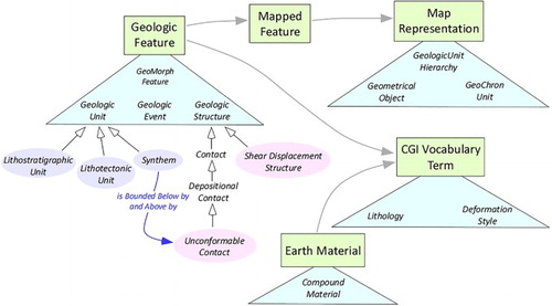
The reconstruction of the geological evolution, onto which the subdivisions of the Map Legend were grounded, led to the definition of a number of ‘Geologic Event’, here intended as ‘remarkable modification of a given geological context or environment induced by physical (tectonic, sedimentary or petrogenetic) processes’. Many of these Geologic Events are represented by regional-scale unconformities preserved in the stratigraphic record and correlatable across different geological domains ().
Figure 1. Scheme showing the relations between the geologic features and geologic concepts used for the construction of the Map Legend. Concepts and features (represented by plain text labels) are grouped in distinct ontologies or vocabularies (represented by coloured triangles). See ‘WikiGeo’ (https://www.di.unito.it/wikigeo/index.php?title=Pagina_principale) for further details.
3. How to read the Map
The Map consists of ‘Mapped Features’ that represent geologic units sensu GeoSciML (‘a body of material in the Earth whose complete and precise extent is inferred to exist. Spatial properties are only available through association with a MappedFeature’), http://www.geosciml.org/geosciml/4.0/documentation/html/EARoot/EA1/EA3/EA1/EA123.htm. The instances of the Map Legend correspond to lithostratigraphic units (‘a geologic unit defined on the basis of observable and distinctive lithologic properties or combination of lithologic properties and stratigraphic relationships’, GeosciML, version 4.0), possibly grouped together into a single ‘Map Instance’ through a correlation process. In the sedimentary successions, the lithostratigraphic units are grouped into Synthems, bounded by unconformities (International Stratigraphic Guide, http://www.stratigraphy.org/index.php/ics-stratigraphicguide). The identification of unconformities is based on objective criteria (presence at the base of an angular unconformity; erosional truncation; abrupt facies contrast or composition change, contravening the ‘Walther rule’) that can be used in the field without the use of biostratigraphy (CitationClari, Dela Pierre, & Martire, 1995). The Metasedimentary successions have been subdivided in lithostratigraphic units grouped into informally defined ‘parasynthems’ which can be correlated through the different tectonic units of the Piemonte Western Alps on the basis of their primary lithologic or stratigraphic characters (see below for further details).
The metamorphic rocks were subdivided into lithodemic units (i.e. ‘lithostratigraphic units that lack stratification’ or that ‘do not conform to the Law of Superposition’; INSPIRE, Data Specification on Geology), that are grouped in metamorphic complexes, intended as geologic units consisting of lithodemes of more than one genetic class (CitationNorth American Commission on Stratigraphic Nomenclature, 2005).
The lithostratigraphic units and lithodemic units have been grouped, in many cases, into lithotectonic units sensu GeoSciML (‘geologic unit defined on the basis of structural or deformation features, mutual relations, origin or historical evolution’), represented in the Map Legend by tile groups separated by ‘Titles’. The lithotectonic units are bounded by shear displacement structures sensu GeoSciML (‘a generalised shear displacement structure without any commitment to the internal nature of the structure: anything from a simple, single “planar” brittle or ductile surface to a fault system … of both brittle and ductile nature’). Four hierarchy orders of lithotectonic units (Geol_Unit1, … Geol_Unit4) exist in the Map Legend and are represented by a non-formal conceptual scheme (reported in the Map Legend), that shows the relations of the lithotectonic unit with the seven palaeogeographic domains or genetic contexts (see Section 5) to which they have been referred to (relation: ‘palaeogeographic pertinence’). The contacts between the lithotectonic unit and/or geologic units are represented by lines corresponding to stratigraphic contacts (unconformities, blue lines) or tectonic contacts (shear displacement structure, red lines), whose origin is related to some encoded Geological Events.
It must be remarked that the Map Legend is essentially based on lithostratigraphic criteria, where the geologic units are distinguished into polycyclic basements (mainly pre-Alpine), cover units (mainly Mesozoic), synorogenic basins (Cenozoic) and synorogenic magmatic bodies (cross-cutting all the previous cited subdivisions). Once grouped into the above-cited main subdivisions, the geologic units have been listed in the Legend following their present geometric position (from the external to the internal ones or from the top to the bottom) for each distinct tectonic stack.
4. Geological setting of the region
4.1 The Alps–Apennines orogenic system
The geomorphological framework of Piemonte shows several orographic features: the Alps and Apennines mountain ranges, the hills of Monferrato and Langhe, the end-moraine systems and fluvio-glacial or alluvial fan at the outlet of major Alpine and Apenninic valleys, major glacial lakes in the northern part of the region and the wide alluvial plains of Po River. This highly variable geomorphological framework mirrors an equally complex geologic and tectonic context, almost unique for its large variety of lithological and structural features. This has induced enormous scientific interest, promoting a large quantity of multidisciplinary scientific papers and maps.
The geological setting of Piemonte ideally encompasses an almost complete section of the Earth’s crust, ranging from deep lithospheric mantle rocks to oceanic basalts and relevant sedimentary covers, from the plutonic and volcanic continental rocks to the overlying carbonate and siliciclastic sedimentary covers, as well as to many kinds of metamorphic rocks formed in different geodynamic contexts and at different pressure and temperature conditions. Several Paleozoic to Cenozoic and Quaternary associations of rocks, referred to a long sequence of magmatic, metamorphic and sedimentary events, can be recognised. All this variety of geological units can be considered (as discussed below) as parts of the ‘Alps–Apennines orogenic system’.
The complexity of Piemonte geology is the result of a continuous geodynamic process which, since the Rhaetian-Hettangian, led to the formation of two continental ‘passive’ margins: the ‘Palaeo-European Margin’ and the ‘Palaeo-Adriatic Margin’, and two oceanic zones: the Liguria–Piemonte Domain and the Valais Domain (CitationBernoulli & Jenkins, 2009; CitationBertotti, Picotti, Bernoulli, & Castellarin, 1993; CitationDal Piaz, 1974; Citation1999; CitationDal Piaz, Bistacchi, & Massironi, 2003; CitationDal Piaz, Hunziker, & Martinotti, 1972; CitationDewey & Bird, 1970; CitationDewey, Pitman, Ryan, & Bonnin, 1973; CitationHandy, Schmid, Bousquet, Kissling, & Bernoulli, 2010; CitationMohn, Manatschal, Müntener, Beltrando, & Masini, 2010; CitationSturani, 1975; CitationTrumpy, 2001). Since the Late Cretaceous, the European and Adriatic continental plate margins began to converge (CitationLe Pichon, 1968) inducing the subduction of the interposed oceanic lithosphere. This process led, since the middle-late Eocene, to the collision and mutual indentation of the two plate margins. In this framework, the Alps–Apennines orogenic system originated, involving continental and oceanic crustal units that were affected, at a very different extent, by metamorphic and tectonic reworkings (see CitationDal Piaz, 2010 for a review). In the early Oligocene, magmatic complexes intruded the orogenic belt as a consequence of the crust subduction (see CitationAlagna, Peccerillo, Martin, & Donati, 2010, for a review). Contemporaneously, since the middle Eocene, synorogenic sedimentary basins developed: the middle Eocene–early Oligocene Alpine foreland basin in the outer part of the Alpine chain, the Eocene–Messinian Tertiary Piemonte Basin (BTP) and the Pliocene–Quaternary basins in the inner part. The sediments of these basins, which became, in turn, part of the overall orogenic system, recorded the syn-collisional tectonic evolution of the Alps–Apennines orogenic system.
From a geographic perspective, the Piemonte Alps–Apennines system can be subdivided into distinct orographic features:
(a) the Western Alps, represented in Piemonte by the Maritime, Cottian and parts of the Graian, Pennine and Lepontine Alps, which display the deeper crustal portions of the Alps–Apennines orogenic system, affected by pre-Alpine and Alpine metamorphism. Discontinuous portions of the Mesozoic sedimentary covers of the continental and oceanic crusts, metamorphosed at different degrees, as well as Eocene-Rupelian deposits of the Alpine Foreland Basin, are exposed in the Cottian, Maritime and Ligurian Alps. These are, at a minor extent, also exposed in the Ossola sector, in the ‘Lakes district’ and in the Canavese–Biellese area. The Piemonte Alps roughly correspond to the internal and axial sectors of the Western Alps double-vergent orogenic belt (see CitationBeltrando, Compagnoni, & Lombardo, 2010; CitationDal Piaz et al., 2003; CitationPfiffner, Lehner, Heitzmann, Mueller, & Steck, 1997; CitationRosenbaum, Lister, & Duboz, 2002; CitationRoure, 1996; CitationRoure, Polino, & Nicolich, 1990 for a review). The internal sector is bounded by the Periadriatic Lineament (Insubric Fault, Canavese Line) and by the south, southeast- and east-vergent (‘retrovergent’) thrust fronts on its Padane side.
Portions of these sedimentary successions, which did not undergo metamorphic transformations at depth, are now part of the northern Apennines and of the Maritime and Ligurian Alps.
(b) The southern part of Piemonte Alps (represented by the Ligurian Alps between Tenda Pass and Cadibona Pass), which are characterised by polycyclic metamorphic rocks (Ligurian Briançonnais basement) and late Carboniferous to Permian sedimentary-volcaniclastic sequences covered by Mesozoic carbonate successions of the palaeo-European margin, are in turn unconformably covered by Eocene to Pliocene sediments of the synorogenic basins. The southern Piemonte Alps belong to the external sector of the Western Alps orogenic belt, which is bounded by south- and southwest-vergent thrust systems bounding it from the foreland domains (CitationFord, Lickorish, & Kusznir, 1999; CitationJourdon, Rolland, Petit, & Bellahsen, 2014).
(c) The Apennines mountain range to the East of Cadibona Pass extends in Piemonte up to the boundary with the Emilia-Romagna and Lombardia regions. From Cadibona Pass to the Lemme valley, the Apennines show polycyclic basement rocks and the overlying Mesozoic carbonate successions of the palaeo-European margin, as well as metamorphic rocks derived from the oceanic Liguria–Piemonte Domain (from Erro valley to Lemme valley). In the geological literature, these units are included in the Ligurian Alps, although they belong, from a geographic and orographic perspective, to the Apennines. To the northeast of the Lemme valley, non-metamorphic rocks belonging to the oceanic Liguria–Piemonte Domain or to the Eocene to Pliocene synorogenic basins are prevalent. These units represent the shallower part of the orogenic system, never involved in deep tectonic processes, and are a part of the Northern Apennines tectonic belt, formed since the late Oligocene in response to the overthrusting, toward the East and NE, of the Ligurian units onto the palaeo-Adriatic continental margin (CitationElter, 1973; CitationElter & Pertusati, 1973) and overlaying Cenozoic sediments of the Po plain subsurface (CitationBiella et al., 1997; CitationCassano, Anelli, Fichera, & Cappelli, 1986; CitationFalletti, Gelati, & Rogledi, 1995; CitationPieri & Groppi, 1981; CitationRoure, 1996; CitationRoure et al., 1990).
(d) The hills of the Langhe, Alto Monferrato, Borbera-Grue, Monferrato and Torino areas consist of sedimentary units of the synorogenic basins, deformed and uplifted during the Cenozoic and Quaternary. The Padane alluvial basin (e.g. the Vercelli and Novara alluvial plains) and the Savigliano and Alessandria basins are filled by Quaternary successions whose deposition was controlled by recent tectonics (CitationDelacou, Sue, Champagnac, & Burkhard, 2004; CitationEva & Solarino, 1998; CitationMorelli, Piana, Mallen, Nicolò, & Fioraso, 2011; CitationPerrone et al., 2013). For this reason, the Quaternary deposits are here considered as effective parts of the Alps–Apennines system.
In such a complex framework, tens of lithotectonic units were identified and represented on the Map.
4.2. Main Geologic Events recognized at regional scale
A number of main regional-scale Geologic Events punctuated, since late Carboniferous times, the above-described geological evolution (), providing the essential criteria to classify the geologic units. also reports the regional-scale unconformities and metamorphic foliations formed during each Geologic Event.
Table 1. List of the encoded Geologic Events, identified back to late Carboniferous times, which the Geologic Units and Geologic Structures of the Map have been referred to, in order to make correlations at regional scale.
5. Fundamental geologic criteria
The geologic units of the Map are classified based on the main physiographic and palaeogeographic domains () where they are thought to be originally formed according to the more largely accepted reconstructions:
the palaeo-European continental margin,
the distal part of the palaeo-European continental margin,
the Liguria–Piemonte oceanic domain and Valais domain,
the palaeo-Adriatic continental margin,
the synorogenic Cenozoic basins,
the Alpine synorogenic magmatic bodies.
Figure 2. Scheme showing the present distribution of the palaeogeographic and physiographic domains, as well as the geologic units belonging to the other main categories adopted to construct the Map Legend.
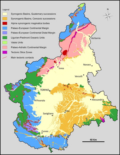
Furthermore, some main ‘Tectonic Slice a Zones’ have been identified as major geological domains consisting of assemblages of geologic units (tectonic slices) pertaining to different palaeogeographic domains, whose stratigraphic and/or tectonic relations are so complex that their grouping in a comprehensive, highly tectonised domain, has been thought as the best solution. The ‘palaeo-European margin’ concept is here used sensu CitationHandy et al. (2010) and CitationMohn et al. (2010), where the Briançonnais domain is viewed as an isolated part of the European continental margin placed between the Valais and Liguria–Piemonte oceanic domains (for the northern part of Piemonte) and a portion of the hyperextended European continental margin (for the south-western part). The ‘palaeo-Adriatic margin’ concept is here intended in the sense of CitationStampfli et al. (1998), referring solely to the continental margin of the ‘Adriatic plate sensu stricto’. All the Mapped Units are here considered as parts of the ‘Alps–Apennines orogenic system’, which is currently under formation as a whole. This term (in which the words ‘Alps’ and ‘Apennines’ refer solely to their original geographic meaning) refers to all the geologic units involved in the orogenetic processes that affected, since Late Cretaceous, the palaeo-European and the palaeo-Adriatic margins, as well as the Liguria–Piemonte and Valais oceanic domains and the Cenozoic synorogenic sedimentary basins progressively incorporated into the system and resting on both Alpine-type metamorphic and non-metamorphic units. Although, at the scale of the entire western Mediterranean area, the Alps and Apennines show distinct geomorphological, geological and geophysical characters (CitationCarminati & Doglioni, 2012), in Piemonte, where these two mountain ranges join, the distinction between the two corresponding orogens could be controversial or meaningless. Depending on the different criteria used (palaeogeography, metamorphism, tectonic vergence, age of deformation), some geological units (such as the Voltri Unit, the Torino Hill and Monferrato) could be ascribed to either orogens. To avoid these problems, the lithotectonic units of Piemonte have been subdivided on the basis of: (i) the palaeogeographic-geodynamic context where they formed, (ii) the degree of preservation of their primary features, that is whether they have been metamorphosed or not, (iii) their present structural position (in a strict geometric or geographic sense). The conceptual Scheme reported on the Map Legend defines the subdivision criteria used for the classification of Piemonte geologic units, consisting of several hierarchy levels corresponding to the main palaeogeographic domains and different-order lithotectonic units (subdomains). The adopted subdivisions can be compared, although partially different, with previously used classification schemes, for instance the classical subdivision of the northwestern Alps into three main structural domains (see CitationBeltrando et al., 2010; CitationDal Piaz et al., 2003; CitationMolli et al., 2010; CitationPfiffner et al., 1997; CitationSchmid, Fugenshuh, Kissling, & Schuster, 2004 for a review) (see the ‘Tectonic sketch Map’ in the Main Map):
an internal (i.e. placed in the Padane realm of the Alps–Apennines orogen) domain (Southalpine Domain) belonging to the upper plate of the collisional system (Adriatic plate) and only partially involved in the Alpine orogenic process. This domain is made of Variscan and pre-Variscan basement with lower continental crust and upper mantle rocks, which underwent minor Alpine metamorphism, followed by Permian volcaniclastic deposits and a Mesozoic sedimentary succession. This domain is bounded by the Periadriatic Lineament (Insubric Fault, Canavese Line) and by south-to-southeast vergent (‘retrovergent’) thrust fronts on its Padane side;
an external (i.e. placed on the European side of the Alps, mostly in France and Switzerland) domain, belonging to the lower plate of the collisional system and corresponding to the Helvetic, Dauphinois, Provençal and (partially) to the External Briançonnais domains of the geological literature. This domain consists of a Variscan polymetamorphic basement with Carboniferous to Permian sedimentary successions and intrusive bodies, Mesozoic sedimentary covers and Cenozoic synorogenic deposits, which underwent anchizone to lower greenschist facies metamorphism. The external sector is characterised by frontal thrust systems inducing the ‘decollement’ of the Mesozoic–Cenozoic sedimentary covers from their polymetamorphic basements;
a central (axial) part of the orogenic system (partially corresponding to the Penninic domain Auct.), bounded by two main tectonic discontinuities, the Insubric-Canavese Line on the inner side and the Penninic Front on the outer side. They are made up of rock units with different origin involved in the Alpine orogenic prism and thus metamorphosed (CitationBeltrando et al., 2010). These units originally belonged to the Piemonte-Liguria oceanic Domain, to portions of the palaeo-European margin (Briançonnais Domain, Lower and Upper Penninic Domains) and to the palaeo-Adriatic margin (Austroalpine Domain). This domain underwent Alpine metamorphism ranging from greenschist facies to ultra-high-pressure eclogite facies conditions. These historical subdivisions, although not used on the Map as discriminant criteria for the classification of geologic units, have been used to draw the Tectonic sketch Map, which gives an alternative – but comparable – representation with respect to the Map Legend scheme.
The geological units cropping out in the geographic Apennines have been classified on the basis of the same genetic criteria adopted for the units of the Alps, so that in some cases (e.g. the Ligurian non-metamorphic units) they are grouped together with the ‘Alpine’ ones. Finally, for the classification of the sedimentary successions of the synorogenic basins (Tertiary Piemonte Basin Auct., Alpine Foreland Basin, Pliocene and Quaternary basins), we opted mostly for lithostratigraphic subdivisions and grouping of units into Synthems bounded by regional-scale unconformities (see below).
6. Map representation criteria
6.1. Lithostratigraphic criteria – metamorphic and sedimentary rocks
The Map Legend was built using lithostratigraphic criteria, that is, subdividing rocks into geologic units on the basis of their compositional and textural features and their subsequent subdivisions into formal and/or informal lithostratigraphic units. Consequently, the first step for the classification of the geologic units was their attribution to either metamorphic or ‘non-metamorphic’ rock classes. A metamorphic rock is here intended as a rock whose primary features are ‘mostly’ (not necessarily ‘completely’) overprinted by secondary petrogenetic processes and whose main distinctive features (e.g. main foliation or layering) are due to dynamic internal re-organisation or mineralogical–chemical transformation. Therefore, the Piemonte Geological Map Legend simply separates the metamorphic units from the ‘non-metamorphic’ ones, and does not classify them on the base of their ‘metamorphic grade’, which would have induced very great difficulties in the map synthesis, due to the inhomogeneous availability of such kind of data.
6.1.1. Subdivision of sedimentary units
Several unconformities have been recognised () that allow subdivision of the stratigraphic successions into Synthems. Each Synthem, the fundamental unit of the Map Legend for the sedimentary successions, contains groups of coeval lithostratigraphic units (formations or members), already defined in the literature, and is bounded by regional-scale unconformities. In each Synthem, the lithostratigraphic units are genetically related, as they originated in different but adjoining depositional systems during the same time interval, and so the Synthems also have a chronostratigraphic value. The use of Synthems allowed a correlation of geographically separated sedimentary bodies, for example, in the Pliocene succession, in the Tertiary Piemonte Basin (from Langhe to Borbera-Grue and Torino Hill-Monferrato system) or in the palaeo-European margin (Briançonnais, Dauphinois and Provençal successions). In the marly or clayey successions, unconformities can be hard to trace laterally, due to the non-continuous presence of lithostratigraphic markers; in those cases they were mapped laterally anyway, as for the D4 and D8. The title of each graphical tile of the Legend reports the distinctive lithological features and the age of each Synthem, whereas the describing text reports the lithostratigraphic units of that Synthem.
6.1.2. Subdivision of Metasedimentary Units
The Metasedimentary successions have been subdivided into the same stratigraphic units used for the non-metamorphic successions. The criteria used for separating the metamorphic sedimentary units are the recognition of the main unconformities (from S0 to S4, see ) or their inference, in the case of strong transformations of rocks by the effects of metamorphism. These groups of metamorphic units cannot be considered properly as synthems but as ‘parasynthems’, as we informally define this kind of units. The parasynthems (labelled as AC0, … AC4) can be correlated through different tectonic units of the Piemonte Western Alps on the basis of their primary lithologic or stratigraphic characters. The recognition, or inference, of the main unconformities bounding the parasynthems, thus allows the correlation of the related Geologic Events () across metamorphosed and non-metamorphosed rock domains, providing an important key for the interpretation of the regional geologic evolution. Furthermore, in the GeoPiemonte Map some slivers of ‘incertae sedis’ sedimentary rocks, preserved as discontinuous and partially detached portions covering the polycyclic basement, have also been comprehensively grouped as ‘slivers of undifferentiated metasedimentary covers’. These also include the major gypsum masses cropping out along the tectonic contacts separating the main lithotectonic units of the Piemonte Alps, where breccias and fault rocks (Carnieules Auct.) are also commonly present.
6.2. Representation of Quaternary succession
The mapping of the continental Quaternary deposits deals with several methodological problems, such as:
a heterogeneous dataset with different geographic distribution, clustering and quality depending on the aims and scale of representation;
the different criteria adopted over time for classifying continental units (e.g. chronostratigraphy, lithostratigraphy, morphostratigraphy, etc.);
the scarcity of radiometric (i.e. 14C, U/Th) and biostratigraphic data.
The use of criteria based on the recognition of unconformity-bounded lithostratigraphic units and feeder catchments could solve those problems, but it seems unreliable for synthesis maps in which detailed stratigraphic subdivisions are unrepresentable. Furthermore, correlations among units physically separated are defective if robust chronological data are lacking. In order to bypass these difficulties, three sedimentary basins, with distinct morphologic and lithotectonic characteristics that can be defined since the late Pliocene, were distinguished: the Western Po Basin, the Savigliano Basin and the Alessandria Basin (sensu CitationIrace et al., 2009, Citation2017). Each basin consists of several depositional systems related to major catchments, characterised by individual stratigraphic architectures as a response to tectonic and climatic events. For each depositional system, a detailed stratigraphy has been established on the basis of unconformities bounding the sedimentary units. The major depositional systems were firstly separated using a morphostratigraphic approach coupled with analyses of subsurface data. Subsequently, the hierarchy of the bounding unconformities was established making physical and chronological correlations of surface and subsurface data. Moreover, the deposits located in the modern fluvial river beds and in mountains and hills, outside the three above-mentioned basins, have been grouped as ‘ubiquitous deposits’, sensu CitationPolino et al. (2002) and CitationBini et al. (2004). Stratigraphic correlations of these deposits are unreliable because of the impossibility to extend, in the mountain catchments, the stratigraphic subdivision used in the plains. Some other Quaternary geological units were represented by direct evidence of morphological features such as erosional scarps, alluvial fans and moraine ridges. For this purpose, a high-resolution topographic map with 2 m spaced contour lines were generated for the whole region from the ‘DTM 2009-2011 Piemonte ICE’ with a grid cell size of 5 m.
6.3. Tectonic criteria
The Map reports two distinct hierarchy levels of tectonic Geological Contacts (‘Shear Displacement Structure’ – SDS sensu GeoSciML):
first level: tectonic contacts between first-order geologic units (lithotectonic units);
second level: faults and shear zones developed within a single geologic unit or cutting across different geologic units.
7. Conclusions
The Piemonte Geological Map derives from a thorough revision of available geological maps and literature, partially reinterpreted and integrated with unpublished original data. The revision and harmonisation of the existing and new data have been based on some general criteria used for the classification of geologic units and their representation on the Map. These criteria (see conceptual scheme on the Map Legend) provided the constraints to design the GIS geodatabase architecture, which drove the graphical representation of the geological features. These criteria firstly aimed at giving a lithostratigraphic, hierarchical subdivision of Piemonte geologic units and then at grouping them into lithotectonic units, in their turn referred to first-order palaeogeographic subdivisions. The description of the geologic features, here provided using shared, retraceable concepts and controlled vocabularies consistent with IUGS Descriptive Standards and the EU INSPIRE directive, represents the ‘added value’ of the Map.
Software
The preparation of the topographic basemap and compilation of the geological map (polygons and lines) were performed using Esri ArcGIS. The database was managed using QuantumGIS, version 2.8. The final layout of the Map, Tectonic sketch Map and Legend were assembled using Adobe Illustrator CS5 Version 15.1.0.
GEOLOGY OF PIEMONTE REGION (NW Italy, Alps-Apennines junction zone).doc
Download MS Word (109 KB)GEOLOGY OF PIEMONTE REGION (NW Italy, Alps-Apennines junction zone).pdf
Download PDF (2.9 MB)GEOLOGY OF PIEMONTE REGION (NW Italy, Alps-Apennines junction zone).pdf
Download PDF (108.7 MB)Acknowledgements
Roberto Compagnoni is kindly acknowledged for multiple, enhanced revisions of several versions of the Map and manuscript, as well as for fruitful and pleasant discussions on Piemonte geology. Enrico Bonansea and Luca Forestello (Arpa Piemonte) are thanked for having prepared and provided a dedicated version of the ‘Multiscale Cross-Borders Topographic Map’ of Piemonte and adjoining regions. Elia Mulazzano, Luca Mallen and Gabriele Nicolò controlled the consistency of the Map database and handled the final graphical set-up of the Map, Legend and schemes. Chris Orton, Simone Fabbi and Laura Federico are acknowledged for their accurate revisions of the manuscript and map. Giorgio Vittorio Dal Piaz is also thanked for several useful suggestions.
Disclosure statement
No potential conflict of interest was reported by the authors.
Related Research Data
References
- Alagna, K. E., Peccerillo, A., Martin, S., & Donati, C. (2010). Tertiary to present evolution of orogenic magmatism in Italy. Journal of the Virtual Explorer, 36, 1–63. doi: 10.3809/jvirtex.2010.00233
- Beltrando, M., Compagnoni, R., & Lombardo, B. (2010). (Ultra-) High-pressure metamorphism and orogenesis: An alpine perspective. Gondwana Research, 18, 147–166. doi: 10.1016/j.gr.2010.01.009
- Bernoulli, D., & Jenkins, H. (2009). Ancient oceans and continental margins of the Alpine- Mediterranean Tethys: Deciphering clues from Mesozoic pelagic sediments and ophiolites. Sedimentology, 56, 149–190. doi: 10.1111/j.1365-3091.2008.01017.x
- Bertotti, G., Picotti, V., Bernoulli, D., & Castellarin, A. (1993). From rifting to drifting: Tectonic evolution of the South Alpine upper crust from the Triassic to the Early Cretaceous. Sedimentary Geology, 86, 53–76. doi: 10.1016/0037-0738(93)90133-P
- Biella, G., Polino, R., de Franco, R., Rossi, P. M., Clari, P., Corsi, A., & Gelati, R. (1997). The crustal structure of the western Po plain: Reconstruction from the integrated geological and seismic data. Terra Nova, 9, 28–31. doi: 10.1046/j.1365-3121.1997.d01-5.x
- Bini, A., Borsato, A., Carraro, F., Carton, A., Corbari, D., Cucato, M., … Pellegrini, G. B. (2004). Definitions of terminologies used in the mapping of Quaternary deposits in the Alpine area. Italian Journal of Quaternary Science, 17, 75–82.
- Carminati, E., & Doglioni, C. (2012). Alps vs. Apennines: The paradigm of a tectonically asymmetric Earth. Earth-Science Reviews, 112(1–2), 67–96. https://dx.doi.org/10.1016/j.earscirev.2012.02.004 doi: 10.1016/j.earscirev.2012.02.004
- Cassano, E., Anelli, L., Fichera, R., & Cappelli, V. (1986). Pianura Padana: Interpretazione integrata di dati geofisici e geologici. Paper presented at 73° Congr. Soc. Geol. Ital. (27 pp.), Edizioni AGIP, Roma.
- Cassinis, G., Perotti, C. R., & Ronchi, A. (2011). Permian continental basins in the Southern Alps (Italy) and peri-mediterranean correlations. International Journal of Earth Sciences, 101(1), 129–157. doi:10.1007/s00531-011-0642-6
- Clari, P. A., Dela Pierre, F., & Martire, L. (1995). Discontinuities in carbonate successions: identification, interpretation and classification of some Italian examples. Sedimentary Geology, 100, 97–121. doi: 10.1016/0037-0738(95)00113-1
- Dal Piaz, G. V. (1974). Le métamorphisme de haute pression et basse température dans l'évolution structurale du bassin ophiolitique alpino-apenninique (2e partie). Schweizerische Mineralogische und Petrographische Mitteilungen, 54, 399–424.
- Dal Piaz, G. V. (1999). The Austroalpine-Piedmont nappe stack and the puzzle of Alpine Tethys. Memorie di Scienze Geologiche, 51, 155–176.
- Dal Piaz, G. V. (2010). The Italian Alps: A journey across two centuries of Alpine geology. Journal of the Virtual Explorer, 36, doi:10.3809/jvirtex.2010.00234
- Dal Piaz, G. V., Bistacchi, A., & Massironi, M. (2003). Geological outline of the Alps. Episodes, 26, 3, 175–180.
- Dal Piaz, G. V., & Gosso, G. (1994). Some remarks on evolution of the Alpine lithosphere. In A. Montrasio & E. Sciesa (Eds.), Proceedings of Symposium on CROP-Alpi Centrali (Vol. 2, pp. 91–99), Sondrio, October 1993, Quaderni Geodinamica Alpina e Quaternaria, Milano.
- Dal Piaz, G. V., Hunziker, J. C., & Martinotti, G. (1972). La zona Sesia-Lanzo e l'evoluzione tettonico metamorfica delle Alpi nord-occidentali interne. Memorie della Società Geologica Italiana, 11, 433–461.
- d'Atri, A., Piana, F., Barale, L., Bertok, C., & Martire, L. (2016). Geological setting of the southern termination of Western Alps. International Journal of Earth Sciences, 105, 1831–1858. doi: 10.1007/s00531-015-1277-9
- Delacou, B., Sue, C., Champagnac, J. D., & Burkhard, M. (2004). Present-day geodynamics in the bend of the western and central Alps as constrained by earthquake analysis. Geophysical Journal International, 158, 753–774. doi: 10.1111/j.1365-246X.2004.02320.x
- Dela Pierre, F., Bernardi, E., Cavagna, S., Clari, P., Gennari, R., Irace, A., … Violanti, D. (2011). The record of the Messinian salinity crisis in the Tertiary Piedmont Basin (NW Italy): The Alba section revisited. Palaeogeography, Palaeoclimatology, Palaeoecology, 310, 238–355. doi: 10.1016/j.palaeo.2011.07.017
- Dela Pierre, F., Piana, F., Fioraso, G., Boano, P., Bicchi, E., Forno, M. G., … Polino, R. (2003). Note illustrative della Carta Geologica d'Italia alla scala 1:50.000. Foglio 157 Trino (147 pp.). APAT, Roma.
- Dercourt, J., Gaetani, M., Vrielynck, B., Barrier, E., Biju-Duval, B., Brunet, M. F., … Sandulescu, M. (2000). Atlas PeriTethys, Palaeogeographical maps (I–XX, 269 pp). CCGM/CGMW, Paris.
- Dewey, J. F., & Bird J. M. (1970). Mountain belts and the new global tectonics. Journal of Geophysical Research, 75(14), 2625–2647. doi:10.1029/JB075i014p02625
- Dewey, J. F., Pitman, W. C., Ryan, W. B. F., & Bonnin, J. (1973). Plate tectonics and the evolution of the Alpine system. Geological Society of America Bulletin, 84, 3137–3180. doi: 10.1130/0016-7606(1973)84<3137:PTATEO>2.0.CO;2
- Elter, P. (1973). Lineamenti tettonici ed evolutivi dell'Appennino settentrionale. In B. Accordi (Ed.), Moderne vedute sulla geologia dell’Appennino (183, pp. 97–118). Quaderni: Accad. Naz. Lincei.
- Elter, P., & Pertusati, P. (1973). Considerazioni sul limite Alpi-Appennino e sulle relazioni con I'arco delle Alpi Occidentali. Memorie della Società Geologica Italiana, 12, 359–375.
- Eva, E., & Solarino, S. (1998). Variations of stress directions in the western Alpine arc. Geophysical Journal International, 135, 438–448. doi: 10.1046/j.1365-246X.1998.00649.x
- Falletti, P., Gelati, R., & Rogledi, S. (1995). Oligo-Miocene evolution of Monferrato and Langhe, related to deep structures. In R. Polino & R. Sacchi (Eds.), Atti del convegno “Rapporti Alpi-Appennino e guide alle escursioni”: Peveragno (CN) 31 Maggio-1 Giugno 1994 (Vol. 14, pp. 1–19). Accademia Nazionale delle Scienze.
- Ford, M., Lickorish, W., & Kusznir, N. (1999). Tertiary foreland sedimentation in the Southern Subalpine Chains, SE France: A geodynamic appraisal. Basin Research, 11(4), 315–336. doi: 10.1046/j.1365-2117.1999.00103.x
- Frey, M., Hunziker, J. C., Frank, W., Bocquet, J., Dal Piaz, G. V., Jäger, E., & Niggli, E. (1974). Alpine metamorphism of the Alps. A review. Schweizer Mineralogische Und Petrographische Mitteilungen, 54, 247–290.
- Gaetani, M. (2010). From Permian to Cretaceous: Adria as pivotal between extensions and rotations of Tethys and Atlantic Oceans. In M. Beltrando, A. Peccerillo, M. Mattei, S. Conticelli, & C. Doglioni (Eds.), The Geology of Italy: tectonics and life along plate margins. Journal of the Virtual Explorer, Electronic Edition, 36(6). doi:10.3809/jvirtex.2010.00235
- Ghielmi, M., Minervini, M., Nini, C., Rogledi, S., & Rossi, M. (2013). Late Miocene-Middle Pleistocene sequences in the Po Plain - Northern Adriatic Sea (Italy): The stratigraphic record of modification phases affecting a complex foreland basin. Marine and Petroleum Geology, 42(C), 50–81. doi: 10.1016/j.marpetgeo.2012.11.007
- Handy, M. R., Schmid, S. M., Bousquet, R., Kissling, E., & Bernoulli, D. (2010). Reconciliation plate-tectonic reconstructions of Alpine Tethys with the geological-geophysical record of spreading and subduction in the Alps. Earth-Science Reviews, 102, 121–158. doi: 10.1016/j.earscirev.2010.06.002
- Irace, A., Clemente, P., Natalicchio, M., Ossella, L., Trenkwalder, S., De Luca, D. A., … Violanti, D. (2009). Geologia e idrostratigrafia profonda della Pianura Padana occidentale (135 pp.). Firenze: Edizioni La Nuova Lito.
- Irace, A., Dela Pierre, F., & Clari, P. A. (2005). “Normal” and “chaotic” deposits in the Messinian Gessoso-Solfifera Fm. at the north-eastern border of the Langhe domain (Tertiary Piedmont basin). Memorie della Società Geologica Italiana, 4, 77–85.
- Irace, A., Monegato, G., Tema, E., Martinetto, E., Gianolla, D., Vassio, E., … Violanti, D. (2017). Unconformity-bounded stratigraphy in the Plio-Pleistocene continental record: New insights from the Alessandria Basin (NW Italy). Geological Journal, 52, 177–206. doi:10.1002/gj.2744
- Jourdon, A., Rolland, Y., Petit, C., & Bellahsen, N. (2014). Style of Alpine tectonic deformation in the Castellane fold-and-thrust belt (SW Alps, France): Insights from balanced cross-sections. Tectonophysics, doi:10.1016/j.tecto.2014.06.022
- Lagabrielle, Y., Labaume, P., & de Saint Blanquat, M. (2010). Mantle exhumation, crustal denudation, and gravity tectonics during Cretaceous rifting in the Pyrenean realm (SW Europe): Insights from the geological setting of the lherzolite bodies. Tectonics, 29, doi:10.1029/2009TC002588
- Lemoine, M., Bas, T., Arnaud-Vanneau, A., Arnaud, A., Dumont, T., Gidon, M., … Tricart, P. (1986). The continental margin of the Mesozoic Tethys in the Western Alps. Marine and Petroleum Geology, 3, 179–199. doi: 10.1016/0264-8172(86)90044-9
- Le Pichon, X. (1968). Sea-floor spreading and continental drift. Journal of Geophysical Research, 73(12), 3661–3697. doi: 10.1029/JB073i012p03661
- Lombardo, V., Piana, F., Fioraso, G., Irace, A., Mimmo, D., Mosca, P., … Giardino, M. (2016). The Classification Scheme of the Piemonte Geological Map and the “OntoGeonous” initiative. Rendiconti Online della Società Geologica Italiana, 39( … ), 117–120. doi: 10.3301/ROL.2016.61
- Masini, E., Manatschal, G., & Mohn, G. (2013). The Alpine Tethys rifted margins: Reconciling old and new ideas to understand the stratigraphic architecture of magma-poor rifted margins. Sedimentology, 60, 174–196. doi: 10.1111/sed.12017
- Mohn, G., Manatschal, G., Müntener, O., Beltrando, M., & Masini, E. (2010). Unravelling the interaction between tectonic and sedimentary processes during lithospheric thinning in the Alpine Tethys margins. International Journal of Earth Sciences, 99, 75–101. doi: 10.1007/s00531-010-0566-6
- Molli, G., Crispini, L., Malusà, M. G., Mosca, P., Piana, F., & Federico, L. (2010). Geology of the Western Alps-Northern Apennine junction area: a regional review. Journal of the Virtual Explorer. doi:10.3809/jvirtex.2010.00215
- Morelli, M., Piana, F., Mallen, L., Nicolò, G., & Fioraso, G. (2011). Iso-Kinematic Maps from statistical analysis of PS-InSAR data of Piemonte, NW Italy: Comparison with geological kinematic trends. Remote Sensing of Environment, 115(5), 1188–1201. doi: 10.1016/j.rse.2011.01.003
- Mutti, E., Papani, L., Di Biase, D., Davoli, G., Mora, S., Segadelli, S., & Tinterri, R. (1995). Il Bacino Terziario Epimesoalpino e le sue implicazioni sui rapporti tra Alpi ed Appennino. Memorie della Società Geologica Italiana, 47, 217–244.
- Muttoni, G., Gaetani, M., Kent, D. V., Sciunnach, D., Angiolini, L., Berra, F., … Zanchi, A. (2009). Opening of the Neo-Tethys Ocean and the Pangea B to Pangea a transformation during the Permian. GeoArabia, 14(4), 17–48.
- North American Commission on Stratigraphic Nomenclature. (2005). North American Stratigraphic Code. AAPG Bulletin, 89, 1547–1591. doi: 10.1306/07050504129
- Perrone, G., Morelli, M., Piana, F., Fioraso, G., Nicolò, G., Mallen, G., & Tallone, S. (2013). Current tectonic activity and differential uplift along the Cottian Alps/Po Plain boundary (NW Italy) as derived by PS-InSAR data. Journal of Geodynamics, 66, 65–78. doi: 10.1016/j.jog.2013.02.004
- Pfiffner, O. A., Lehner, P., Heitzmann, P., Mueller, S., & Steck, A. (1997). Deep structure of the Alps: Results from NRP 20. Basel: Birkhäuser.
- Pieri, M., & Groppi, G. (1981). Subsurface Geological Structure of the Po Plain, Italy. Progetto Finalizzato Geodinamica, Agip-CNR, pubbl. 414.
- Polino, R., Borghi, A., Carraro, F., Dela Pierre, F., Fioraso, G., & Giardino, M. (2002). Note illustrative della Carta Geologica d'Italia alla scala 1:50.000 (128 pp). Foglio 132-152-153 Bardonecchia. Servizio Geologico d'Italia, Litografia GEDA, Nichelino (TO).
- Rosenbaum, G., Lister, G. S., & Duboz, C. (2002). Relative motions of Africa, Iberia and Europe during Alpine orogeny. Tectonophysics, 359, 117–129. doi: 10.1016/S0040-1951(02)00442-0
- Rossi, M., Mosca, P., Polino, R., Rogledi, S., & Biffi, U. (2009). New outcrop and subsurface data in the Tertiary Piedmont Basin (NW-Italy): unconformity-bounded stratigraphic units and their relationships with basin-modification phases. Rivista Italiana di Paleontologia e Stratigrafia, 115(3), 305–335.
- Roure, F. (1996). The ECORS-CROP Alpine Seismic Traverse. Programme ECORS-CROP (France). Mémoires de la Société géologique de France, Paris.
- Roure, F., Polino, R., & Nicolich, R. (1990). Early Neogene deformation beneath the Po Plain: Constraints of the post-collisional Alpine evolution. In F. Roure, P. Heitzmann, & R. Polino (Eds.), Deep Structure of the Alps (pp. 309–322). Mémoires de la Société géologique de France, 156; Mémoires de la Société géologique de Suisse, 1; Vol. Spec. Società Geologica Italiana, 1.
- Schmid, S. M., Fugenshuh, B., Kissling, E., & Schuster, R. (2004). Tectonic map and overall architecture of the Alpine orogen. Eclogae Geologicae Helvetiae, 97, 93–117. doi: 10.1007/s00015-004-1113-x
- Sinclair, H. D. (1997). Tectono–stratigraphic model for under-filled peripheral foreland basins: An Alpine perspective. Geological Society of America Bulletin, 109, 324–346. doi: 10.1130/0016-7606(1997)109<0324:TMFUPF>2.3.CO;2
- Stampfli, G. M., Borel, G., Marchant, R., & Mosar, J. (2002). Western Alps geological constraints on western Tethyan reconstructions. Journal of the Virtual Explorer, 8, 77–106. doi: 10.3809/jvirtex.2002.00057
- Stampfli, G. M., Mosar, J., Marquer, D., Marchant, R., Baudin, T., & Borel, G. (1998). Subduction and obduction processes in the Swiss Alps. Tectonophysics, 296, 159–204. doi: 10.1016/S0040-1951(98)00142-5
- Sturani, C. (1975). Explanatory notes on the western Alps (from the Sestri-Voltaggio line to the Val d'Ossola. Structural Model of Italy. Quaderni La Ricerca Scientifica, CNR, 90, 149–174.
- Trumpy, R. (2001). Why plate tectonics was not invented in the Alps. International Journal of Earth Sciences, 90, 477–483. doi: 10.1007/s005310000175
- Vigna, B., Fiorucci, A., & Ghielmi, M. (2010). Relations between stratigraphy, groundwater flow and hydrogeochemistry in Poirino Plateau and Roero areas of the Tertiary Piedmont Basin, Italy. Memorie descrittive della Carta Geologica d'Italia, 90, 267–292.
- Violanti, D. (2012). Pliocene Mediterranean foraminiferal biostratigraphy: A synthesis and application to the Paleoenvironmental evolution of Northwestern Italy. In O. Elitok (Ed.), Stratigraphic analysis of layered deposits (pp. 123–160), Intech. doi:10.5772/35103.