
ABSTRACT
Sinkholes are common in the Friuli Venezia Giulia (FVG) Region (NE Italy), where the presence of karstifiable rocks favours their occurrence accelerated by intense rainfalls. Their existence has been reported since the end of the 1800s along the Tagliamento Valley, in correspondence with the mantled evaporites (gypsum). Furthermore, tens of evaporite sinkholes have been documented on the reliefs adjacent to the village of Sauris and along the narrow W-E-oriented valleys, where regional faults have played a major role in their spatial distribution. This paper reports for the first time an inventory of the sinkholes affecting the evaporites of the FVG Region. These phenomena were mapped and categorised using a genetic classification. The main output is an A0-format map, which incorporates a 1:50,000 scale Sinkhole Inventory Map (SIM). The SIM encompasses 552 sinkholes. The cover suffosion sinkholes are the most abundant, followed by bedrock collapses. There is a clear prevalence of the circular shape (65%) over other shapes. Diameters are 1–140 m, with depths ranging 0.1–40 m with a mean value of 4.5 m. The SIM can motivate regional planning authorities to perform further investigations aimed to understand the geomorphological evolutions of these phenomena.
1. Introduction
Sinkholes or dolines are closed depressions and are peculiar to karst landscapes. The term sinkhole is widely used in North America and by engineers, but doline is the term most commonly used in the geomorphological world. Doline comes from the Slavic dolina (CitationCvijić, 1893). The genesis and evolution of these depressions is caused by the action of the dissolution of soluble rocks or deposits in addition to internal erosion and/or gravitational processes (CitationGutiérrez, 2016; CitationGutiérrez, Guerrero, & Lucha, 2008; CitationGutiérrez, Parise, De Waele, & Jourde, 2014; CitationParise, 2015; CitationWaltham, Bell, & Culshaw, 2005). Sinkholes affect several European countries such as Spain (CitationGalve et al., 2009a; CitationGutiérrez, Calaforra, et al., 2008), England (CitationCooper, Farrant, & Price, 2011), Albania (CitationParise, Qiriazi, & Sala, 2004) and Italy (CitationCaramanna, Ciotoli, & Nisio, 2008; CitationMargiotta, Negri, Parise, & Quarta, 2016). Friuli Venezia Giulia (FVG) is one of the most impacted regions in Italy (CitationBurelli, Cleva, Cucchi, & Oberti Di Valnera, 2004; CitationCalligaris, Zini, Cucchi, & Stefanelli, 2010; CitationCucchi & Piano, 2002; CitationDe Waele et al., 2017; CitationNisio, Caramanna, & Ciotoli, 2007; CitationZini et al., 2015a).
Subsidence sinkholes (sensu CitationGutiérrez, Calaforra, et al., 2008) are abundant and recurrent in this area and are correlated to the presence of carbonate and evaporite rocks which outcrop or are mantled by alluvial deposits (). In the NW sector of the FVG region, evaporite sinkholes are a well-known natural phenomenon and have been recognised since the end of the 1800s (CitationGortani, 1965; CitationMarinelli, 1897), as they represent a serious threat to man-made structures, such as buildings and roads (CitationCalligaris, Devoto, Zini, & Cucchi, 2017).
Figure 1. Sketch of the evaporite outcrops (in darker colours) and of the mantled or overlaid by a non-karst rock evaporites (in lighter colours) in the study area.

Recently, CitationZini et al. (2015a) applied an integrated approach to investigate sinkholes affecting the village of Quinis, located in the Tagliamento River valley. Several houses, the church and its bell tower were damaged by the occurrence of extensive subsidence phenomena related to the presence of mantled evaporites.
To assess a sinkhole geo-hazard associated with evaporite karst terrain, one fundamental task is to identify their spatial distribution at a regional scale. This paper presents a sinkhole inventory of the subsidence evaporite sinkhole of FVG sensu CitationGutiérrez et al. (2014). The inventory is an extract of a broader and still ongoing project related to the whole region and also extended to solution sinkholes in limestone or carbonate rocks.
The Sinkhole Inventory Map, hereinafter referred to as the SIM, was produced by means of traditional investigations such as desk studies and extensive field activities. Five hundred fifty-two sinkhole phenomena were recognised and classified using the classification proposed by CitationGutiérrez, Calaforra, et al. (2008). All the data derived from activities and investigations populate a geodatabase. The latter includes dimensions and shapes of sinkholes, states of activity and all the data regarding known historical information.
2. Geological setting of the FVG region
The FVG region () is the only location in Italy where it is possible to find rocks from the entire geological time-scale, from the Paleozoic to Cenozoic for a thickness of approximately 10 km (CitationVenturini, 2006).
Figure 2. (A) Lithological sketch of rock materials and main structural faults of the Friuli Venezia Giulia region. Formations were combined producing few main lithological units. (B) Simplified N–S cross–section representing the salient structural characteristics of the study area.
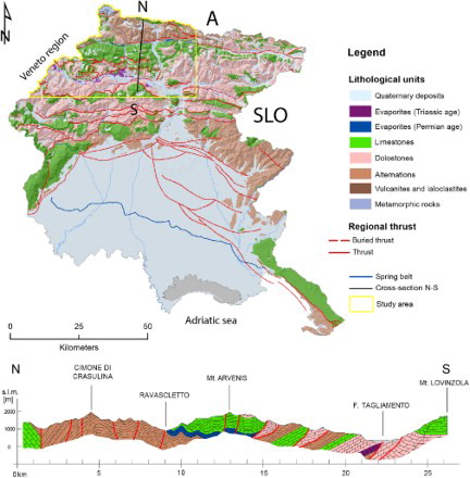
In the northern sector, at the border with Austria, the older rocks outcrop (Ordovician–Triassic). Moving South, a wide belt which includes the Carnian and Julian Alps and Prealps is characterised by the presence of Triassic outcrops, sometimes deeply karstified. The Cretaceous and Paleogene outcrops are identifiable only south of the relief, just upstream of the lowlands which are characterised by Quaternary sediments typical of the megafans deposited by the major regional rivers. Tills and moraines are still present in the area as witnesses of a past in which glaciers mantled the northern part of the region.
The regional territory was exposed to the Alpine orogeny (Paleocene-Pliocene), which is significant for the area. The collision between the African and European plates crushed either side of the Apula microplate. The neoalpine phase of the Alpine orogeny which began during the last 25 M years (Miocene) caused a crustal shortening due to N–S compression and the formation of the major thrusts which are E–W oriented. The mountain area present in the northern part of the FVG region is due to these compressions.
Within this complex framework, the evaporite sequences (mainly made of gypsum) are considered the level which acted as a tectonic lubricant on a large scale, allowing for the detachment of the Permian or Permo-Triassic units from the overlying Triassic-Jurassic ones. Evaporites can be identified in the E–W-oriented valleys ( and ) in correspondence with the main Alpine thrusts.
From a geomorphological perspective, in the northern areas, the main relief referred to as the Alps are identifiable and become less elevated moving south. Before arriving at the plain, the Prealps (Carnian on the W and Julian on the E) border the northern part of the important alluvial plain (having a thickness up to 700 m). In the area of Tolmezzo, where the Tagliamento River outlets into the plain, a significant moraine amphitheatre bears witness to the passage of the Tagliamento glacier during the last glacial maximum. Further south, the plain gently dips towards the Adriatic Sea. The plain is the location of an unconfined porous aquifer in the N (High Plain) and of a multi-layered porous aquifer system in the S (Low Plain). The High Plain and Low Plain are separated by a continuous approximately E–W-oriented spring belt (). In the rest of the Region, as in the mountains (where limestones or dolomitic limestones are abundant) or in the Classical Karst area, good quality freshwater stored in karst aquifers prevail.
2.1. Karst areas of FVG
The FVG region is a small territory of 8000 km2, of which about 5000 km2 are mountainous or hilly areas. Approximately 1900 km2 of the above-mentioned territories are characterised by outcropping carbonate rocks (CitationCalligaris et al., 2017; CitationCalligaris, Boschin, Cucchi, & Zini, 2016; CitationCucchi & Zini, 2009; CitationZini et al., 2014; CitationZini, Calligaris, & Cucchi, 2015b), in facies that vary in lithology from limestone to dolostone allowing manifold manifestations of karst landforms, often notable also thanks to the very high rainfall rate typical of the Alpine and pre-Alpine areas. This means that karst processes affect almost 40% of the regional territory. In addition to carbonate rocks, the NW part of the FVG region hosts further karst areas developed in evaporites from the Permian and Triassic ages (). The outcrop percentage of evaporite karst in the FVG region is close to 1%, of which 25% are Permian and 75% are Triassic. It is the subcropping percentage which is of interest. Most part of the evaporites are in fact mantled by alluvial and glacial deposits or are overlain by non-karst rocks. Evaporite outcrops have been estimated at approximately 25.8%, of which 6.3% are Permian, and 19.5% are Triassic.
One example is the Tagliamento Valley, where extensive subsidence phenomena are associated with the presence of mantled Upper Triassic gypsum (CitationZini et al., 2015a).
2.1.1. Permian evaporite
The evaporites of the Upper Permian age are abundant in the areas of Sauris, Val Pontaiba, Prato Carnico and Ovaro. They are included in the Bellerophon Formation, typical of the transgressive sequence where the gypsum, characterised by micro and saccharoid crystals layered and interbedded with black limestones and dolostones, overlies the continental deposits of the Arenarie della Val Gardena Formation (Upper Permian). The thickness of the sequence is approximately 100 m. Moving upward in the stratigraphic sequence, gypsum is replaced by limestone-dolostone-gypsum vacuolar breccias and dolomitic limestones (CitationCarulli, 2006). These evaporites are represented in purple on the map.
2.1.2. Triassic evaporite
The evaporites of the Upper Triassic (Carnian age) are common in the areas of Forni di Sotto, Forni di Sopra, Ampezzo, Socchieve and Enemonzo. They belong to the transgressive sequence that represented a climatic event at a global scale at the end of the Upper Carnian. As defined by CitationCarulli (2006) and CitationVenturini (2006), the litho-facies are grey marly dolostones, light grey vacuolar dolostones with cm-thick marly layers (Raibl Group). The most characteristic lithology is represented by grey and pink coloured saccharoid gypsum, rich in clayey impurities, often in mm-thick rhythmic laminae, typical of evaporite lagoon deposit. The thickness of the whole sequence is about 600 m, represented in dark orange on the map.
3. Methods
Preliminary research activities were devoted to the collection and analysis of reports, documents and maps located in the archives of the Regional Geological Survey, municipalities and those owned by the Department of Mathematics and Geosciences of the University of Trieste. The outcomes of these analyses, supported by the interpretation of aerial photos and Digital Terrain Models (DTMs), which allowed the detection of possible areas affected by sinkhole phenomena. The DTMs used (1 m resolution) were created using Aerial Laser Scanner (ALS) data acquired over the period 2006–2010 by the Civil Defence of the FVG region.
Based on these results, extensive field surveys allowed for the identification and classification of hundreds of sinkholes located in the NW part of the FVG region.
Sinkholes were classified according to the classification developed by CitationGutiérrez et al. (2014). It uses two terms following the well-known slope-failure classification developed by CitationCruden and Varnes (1996). The first term is related to the material affected by the downward gravitational movement (cover, bedrock or caprock) whereas the second term is related to the main type of process involved in the subsidence mechanism (collapse, sagging, suffosion).
In the geodatabase, only 6% of the data have chronological information. Dated phenomena are mainly located in urban areas where damage has occurred, where information is certain and where reactivations are frequent. The first recorded sinkholes in the region date back to the 1897 and 1960s (the cover collapse sinkhole, Quinis area) and in some areas, where suffosion sinkholes are present, it can be said that phenomena are still active showing a paroxysmal phase usually linked to groundwater table fluctuations (CitationZini et al., 2015a).
The map produced for this paper is A0-format, which includes:
A 1:50,000 scale SIM drawn over a simplified lithological map and related legend (central part of the map);
A Sinkhole Density Map and its legend (left slice of the map);
A location map describing the geographical setting;
A figure summarising the percentages of different types of subsidence sinkholes according to the classification proposed by CitationGutiérrez et al. (2014).
The lithological areas and the faults in the SIM integrate data from:
Carta geologica del Friuli Venezia Giulia, 1:150,000 scale, from CitationCarulli (2006);
Carta geologica delle Alpi Carniche (Foglio occidentale), 1:25,000 scale, from CitationVenturini, Pondrelli, Fontana, Delzotto, and Discenza (2001);
Carta geologica delle Alpi Carniche (Foglio orientale), 1:25,000 scale, from CitationVenturini, Pondrelli, Fontana, Delzotto, and Discenza (2002);
Maps and reports produced for municipalities’ land-use planning (Piani Regolatori Generali Comunali – PRGC, 1:5000 scale);
Detailed field activities for specific areas that allowed the integration and refinement of the lithological and structural features presented in the geological maps used (scale 1:5000).
Table 1. List of lithological classes inserted in the SIM (first column) and associated lithostratigraphic units in the 1:150,000 scale map produced by CitationCarulli (2006).
To highlight the evaporite outcrops, we separated the Permian and Triassic (Carnian) evaporite distinguishing them into two different units. Evaporite rocks are represented in full and darker colours, whereas all other geolithological units are represented using a pastel colour. The Main Map also includes urban areas, roads, rivers and contours.
The Sinkhole Density Map was made calculating a magnitude-per-unit area from point or polyline features using the Kernel function (CitationOkabe, Satoh, & Sugihara, 2009) with a searched radius (bandwidth) of 3100 m and classified using Jenks natural breaks (CitationJenks, 1967) in 6 classes, rounding up the higher subdivisions to an integer value.
4. Results
Following the classification proposed by CitationGutiérrez et al. (2014), 552 subsidence sinkholes were recorded and classified. Only the following four types were recognised in the evaporites of the FVG region:
Bedrock collapse sinkhole: Their evolution is linked to the presence of cavities in the evaporite subsurface characterised by the development of cupola-shaped failure plains (CitationGutiérrez et al., 2014) evolving in quite stable arched roofs characterised by the upward migration of the collapses. This process leads to the formation of steep-walled bedrock collapse sinkholes ( (A,B)).
Caprock collapse sinkhole: The process is the same as that described for the bedrock collapse sinkhole. The only difference is the presence of a non-karst rock (as the terrigenous Werfen Fm. at Sauris) overlying a karst bedrock ( (C–E)).
Cover collapse sinkhole: Their evolution is linked to the brittle behaviour of the cover material (mainly Quaternary alluvial deposit). The formed arched cavities migrate upward, generating the formation of a collapse. They occur suddenly and have initially scarped or overhanging sides (CitationGutiérrez et al., 2014), which could later transform into funnel- or bowl-shaped depressions ( (A,B,C,F)).
Cover suffosion sinkhole: Their evolution is linked to the nature of the cover that behaves as a ductile or loose granular material which gradually settles producing continuous deformations that generate funnel- or bowl-shaped landforms. The granular material progressively migrates downward through the voids producing a progressive settling on the topographic surface ( (D,E)).
The inventory is representative of the ongoing situation. Most of the sinkholes present in the study area were surveyed or identified thanks to the high quality of the ALS data which ensured a good cover of the regional territory, also in uninhabited and pristine areas. Among the inventoried sinkholes (), the cover suffosion sinkholes are dominant reaching a total of 29% and are common in the nearby villages of Enemonzo and Ligosullo. Bedrock collapse sinkholes represent 16% of the entire population and mainly affect the areas of Sauris, Forni di Sopra and Ligosullo. Caprock collapse sinkholes are at 11% and can mainly be identified in mountain areas overhanging Sauris di Sopra and Sauris di Sotto. Cover collapse sinkholes mainly affect the alluvial deposits of the Tagliamento Valley even if they have also been recognised in other intramontane valleys in the areas of Ovasta, Ravascletto and Sauris di Sopra. Twenty-nine per cent are classified as undefined sinkholes (). The latter class includes those phenomena which were detected by desk activities and were not surveyed or not identifiable in the field. In some cases, even if they were recognised in the field, it was not possible to assign them an evolutionary process. The only possible assignment was the outcropping lithological unit. From a lithological perspective, more than 70% of the recorded phenomena are related to Permian gypsum, while only 29% involve Triassic gypsum.
Figure 3. Different types of sinkholes involving bedrock or caprock materials. (A) Bedrock collapse sinkhole (E of Sauris Village). (B) Bedrock collapse sinkhole located near Ovaro Village; (C) Caprock collapse sinkhole (Sauris Village); (D) Caprock collapse sinkhole (Sauris Village); (E) Caprock collapse sinkhole (Sauris Village).
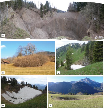
Figure 4. Different types of sinkholes involving cover materials. (A) Cover collapse sinkhole (Forni di Sotto); (B) Cover collapse sinkhole near Paluzza Village, courtesy of Michele Potleca); (C) Cover collapse sinkhole (Ligosullo Village, courtesy of Michela Dini); (D) Socchieve, Cover suffusion sinkhole (Forni di Sotto Village); (E) cover suffusion sinkhole near Viaso Village; (F) cover collapse sinkhole near Ligosullo Village.
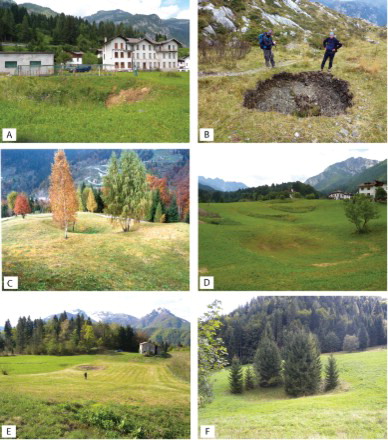
Figure 5. Statistical analyses on the collected parameters: Type of sinkhole, Geomorphological context, sinkhole shape and state of activity.
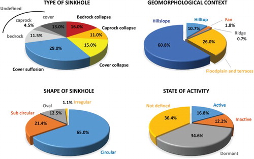
Other parameters were defined in the inventory, one of these is the State of Activity (CitationWP/WLI, 1993) where active sinkholes are those which are currently moving; inactive sinkholes are those which were last active more than one annual cycle of seasons ago, and dormant sinkholes are inactive sinkholes which can be reactivated by their original or other causes. Among the whole population, 12.7% are inactive, 16.7% are active, 34.6% are dormant and almost the same percentage (36.4%) have not been defined (). Several of these data are in fact associated with those phenomena identified using the bibliography, but not always recognisable in the field or for which no data are available concerning the state of activity.
The shape of the phenomena was defined where possible. There is a clear prevalence of circular (65%) over others: 21.4% sub-circular, 12.5% oval and 1.1% irregular (mainly due to the coalescence of more than two phenomena at time).
During the field surveys, the length of the minimum and maximum diameter was also considered. The range of minimum length of the diameter is 1–140 m, with a mean value of 19.1 m; the range of maximum length of the diameter is 1–319 m, with a mean value of 24.3 m. The depth has a range of 0.1–40 m, with a mean value of 4.5 m.
Considering the geomorphological context in which sinkholes were identified, it emerges that 60.8% occur on hillslopes, while 26.0% affect floodplains and terraces ().
We did not encounter anthropogenic sinkholes in the analysed area, but sinkholes have a significant effect on the inhabitants and infrastructure. A well-known example is the village of Quinis, where several houses have been severely damaged over the years and the inhabitants relocated to safer areas (CitationZini et al., 2015a). Another area affected by sinkholes is the village of Ovaro and its surroundings where some buildings were demolished for safety reasons in the 1960s (CitationCalligaris et al., 2017). Currently, new cracks have been found in several other buildings, indicating ongoing activity of the dissolutional and erosional processes.
5. Conclusions
This paper and the related map provide a detailed inventory of the sinkholes linked to the evaporites of the FVG region. The phenomena were recognised using the outputs of desk and field activities and are classified according to CitationGutiérrez et al. (2014).
The main output is a 1:50,000 SIM, which contains 552 sinkholes distributed mainly along the Tagliamento, Degano, Val Lumiei, Val Pesarina and Valcalda valleys where evaporites are outcropping or are mantled by Quaternary deposits. The cover suffosion sinkholes are the most abundant, followed by bedrock collapses. These phenomena affect slopes, floodplains, fans and hilltops, places of infrastructure and human habitation. While it is the case that only a small percentage (2%) of the whole population residing in the FVG region lives in these valleys, continuing to live in the mountains despite the depopulation which has occurred in recent decades, this sparse population is mitigated by the thousands of tourists who visit the valleys. In this framework, the SIM is an essential tool for local authorities for future territorial planning in order to avoid hazardous areas. Furthermore, the analysis of the SIM can motivate regional authorities to produce Sinkhole Susceptibility Maps (CitationCiotoli et al., 2016; CitationGalve et al., 2008, Citation2009b, Citation2011) where phenomena are common and/or recurrent being a fundamental tool for sinkhole geo-hazard assessment and their forecasting.
Software
The map was produced using Esri ArcGIS 10.4, whilst the regional sketch and the figure of different types of sinkhole were digitised using Adobe Illustrator CS6. The Geodatabase was produced using Microsoft Access13.
Evaporite sinkholes of the Friuli Venezia Giulia Region (NE Italy).pdf
Download PDF (9.2 MB)Acknowledgements
The research activities were performed within the framework of the project ‘Realizzazione del censimento regionale dei sinkhole e relativo GIS (Geographic Information System) con Corso formativo e predisposizione delle Linee Guida di rilevamento ed informatizzazione nonché del Glossario dei termini utilizzati’ (Rep. No. 587-15/06/2015) funded by the Geological Survey of Friuli Venezia Giulia. The authors are grateful to Michele Fernetti and Philippe Turpeaud for their suggestions in the production of map and to Prof. Franco Cucchi for the time he devoted to this project and for his invaluable advice. Special thanks go to Karolyn Close who re-edited the text and to the reviewers who contributed to the improvement of the map and the manuscript.
Disclosure statement
No potential conflict of interest was reported by the authors.
ORCID
Chiara Calligaris http://orcid.org/0000-0003-3164-5197
Stefano Devoto http://orcid.org/0000-0002-1804-9887
Luca Zini http://orcid.org/0000-0001-6564-1683
Additional information
Funding
Related Research Data
References
- Burelli, G., Cleva, S., Cucchi, F., & Oberti Di Valnera, S. (2004). Stato di evoluzione di sinkholes in alcune aree montane del Friuli Venezia Giulia. Atti 1° Seminario “Stato dell'arte sullo studio dei fenomeni di sinkholes,” Roma, maggio 2004, APAT Ed., 159–170.
- Calligaris, C., Boschin, W., Cucchi, F., & Zini, L. (2016). The karst hydrostructure of the Verzegnis group (NE Italy). Carbonates and Evaporites, 31, 407–420. doi:10.1007/s13146-016-0320-7
- Calligaris, C., Devoto, S., Zini, L., & Cucchi, F. (2017). An integrated approach for investigations of ground-subsidence phenomena in the Ovaro village (NE Italy). In P. Renard & C. Bertrand (Eds.), EuroKarst 2016, Advances in Karst Science (pp. 71–77). Neuchâtel: Springer International. 8. doi:10.1007/978-3-319-45465-8_8
- Calligaris, C., Zini, L., Cucchi, F., & Stefanelli, N. (2010). Gypsum’s role in the Friuli Venezia Giulia sinkholes; in proceedings of: 2° I sinkholes: gli sprofondamenti catastrofici nell’ambiente naturale ed in quello antropizzato, ISPRA Roma 3-4 dicembre 2009, 213–221.
- Caramanna, G., Ciotoli, G., & Nisio, S. (2008). A review of natural sinkhole phenomena in Italian plain areas. Natural Hazards, 45(2), 145–172. doi:10.1007/s11069-007-9165-7
- Carulli, G. B. (2006). Carta Geologica del Friuli Venezia Giulia, scala 1:150000. Regione Friuli Venezia Giulia, S.EL.CA. Firenze. A cura della Regione Autonoma Friuli Venezia Giulia, Direzione Centrale Ambiente e Lavori Pubblici, Servizio Geologico.
- Ciotoli, G., Di Loreto, E., Finoia, M. G., Liperi, L., Meloni, F., Nisio, S., & Sericola, A. (2016). Sinkhole susceptibility, Lazio Region, central Italy. Journal of Maps, 12, 287–294. doi:10.1080/17445647.2015.1014939
- Cvijić, J. (1893). Das Karstphänomen, Versuch einer morphologischen Monographie. Georaphische Abhandlungen, 5(3), 217–330.
- Cooper, A. H., Farrant, A. R., & Price, S. J. (2011). The use of karst geomorphology for planning, hazard avoidance and development in Great Britain. Geomorphology, 134, 118–131. doi:10.1016/j.geomorph.2011.06.004
- Cruden, D. M., & Varnes, D. J. (1996). Landslide types and processes. In A. K. Turner & R. L. Schuster (Eds.), Landslides, investigation and mitigation ( Vol. Special Report 247, pp. 36–75). Washington, DC: National Academy Press.
- Cucchi, F., & Piano, C. (2002). Ipercarsismo superficiale e sepolto nelle evaporiti del Friuli-Venezia-Giulia. Le voragini catastrofiche, un nuovo problema per la Toscana, Edizioni Regione Toscana, 35–46.
- Cucchi, F., & Zini, L. (2009). Paesaggi carsici nel Friuli Venezia Giulia. Trieste: DiSGAM, Università di Trieste.
- De Waele, J., Piccini, L., Columbu, A., Madonia, G., Vattano, M., Calligaris, C., … Forti, P. (2017). Evaporite karst in Italy: A review. International Journal of Speleology, 46(2), 137–168. doi:10.5038/1827-806X.46.2.2017
- Galve, J. P., Gutiérrez, F., Lucha, P., Bonachea, J., Remondo, J., Cendrero, A., … Sánchez J. A. (2009a). Sinkholes in the salt-bearing evaporite karst of the Ebro River valley upstream of Zaragoza city (NE Spain): Geomorphological mapping and analysis as a basis for risk management. Geomorphology, 108, 145–158. doi:10.1016/j.geomorph.2008.12.018
- Galve, J. P., Gutiérrez, F., Remondo, J., Bonachea, J., Lucha, P., & Cendrero, A. (2009b). Evaluating and comparing methods of sinkhole susceptibility mapping in the Ebro Valley evaporite karst. Geomorphology, 111, 160–172. doi:10.1016/j.geomorph.2009.04.017
- Galve, J. P., Remondo, J., Bonachea, J., Cendrero, A., Gutiérrez, F., Guerrero, J., … Sánchez, J. A. (2008). Development and validation of sinkhole susceptibility models in mantled karst settings. A case study from the Ebro valley evaporite karst (NE Spain). Engineering Geology, 99, 185–197. doi:10.1016/j.enggeo.2007.11.011
- Galve, J. P., Remondo, J., & Gutiérrez, F. (2011). Improving sinkhole hazard models incorporating magnitude-frequency relationships and nearest neighbor analysis. Geomorphology, 134, 157–170. doi:10.1016/j.geomorph.2011.05.020
- Gortani, M. (1965). Le doline alluvionali. Natura e Montagna, 3, 120–128.
- Gutiérrez, F. (2016). Sinkhole hazards. Oxfrod Research Encyclopedia of Natural Hazard Science. Oxford University Press, 1–92 p.
- Gutiérrez, F., Calaforra, J. M., Cardona, F., Ortí, F., Durán, J. J., & Garay, P. (2008). Geological and environmental implications of the evaporite karst in Spain. Environmental Geology. 53, 951–965. doi:10.1007/s00254-007-0721-y
- Gutiérrez, F., Guerrero, J., & Lucha, P. (2008). A genetic classification of sinkholes illustrated from evaporite paleokarst exposures in Spain. Environmental Geology, 53, 993–1006. doi:10.1007/s00254-007-0721-5
- Gutiérrez, F., Parise, M., De Waele, J., & Jourde, H. (2014). A review on natural and human-induced geohazards and impacts in karst. Earth-Science Reviews, 138, 61–88. doi:10.1016/j.earscirev.2014.08.002
- Jenks, G. F. (1967). The data model concept in statistical mapping. International Yearbook of Cartography, 7, 186–190.
- Margiotta, S., Negri, S., Parise, M., & Quarta, T. A. M. (2016). Karst geosites at risk of collapse: The sinkhole at Nociglia. Environmental Earth Sciences, 75, 1–10. doi:10.1007/s12665-015-4848-y
- Marinelli, O. (1897). Fenomeni di tipo carsico nei terrazzi alluvionali della Valle del Tagliamento. Memorie della Società Geografica Italiana, Roma, 8(2), 415–419.
- Nisio, S., Caramanna, G., & Ciotoli, G. (2007). Sinkholes in Italy: First results on the inventory and analysis. In M. Parise & J. Gunn (Eds.), Natural and anthropogenic hazards in karst areas: Recognition, analysis and mitigation ( Geological Society Special Publication no. 279, pp. 23–45). London: The Geological Society. Retrieved May 1, 2007. doi:10.1144/SP279.4
- Okabe, A., Satoh, T., & Sugihara, K. (2009). A kernel density estimation method for networks, its computational method and a GIS-based tool. International Journal of Geographical Information Science, 23(1), 7–32, doi:10.1080/13658810802475491
- Parise, M. (2015). Karst Geo-hazard: Causal factors and management issues. Acta Carsologica, 44(3), 401–414, doi:10.3986/ac.v44i3.1891
- Parise, M., Qiriazi, P., & Sala, S. (2004). Natural and anthropogenic hazards in karst areas of Albania. Natural Hazards and Earth System Sciences, 4, 569–581.
- Venturini, C. (2006). Evoluzione geologica delle Alpi Carniche. Edizioni del Museo Friulano di Storia Naturale, 48, pp. 208.
- Venturini, C., Pondrelli, M., Fontana, C., Delzotto, S., & Discenza, K. (2001). Carta Geologica delle Alpi Carniche, Foglio Occidentale, scala 1:25000. Museo Friulano di Storia Naturale, S.EL.CA. Firenze.
- Venturini, C., Pondrelli, M., Fontana, C., Delzotto, S., & Discenza, K. (2002). Carta Geologica delle Alpi Carniche, Foglio Orientale, scala 1:25000. Museo Friulano di Storia Naturale, S.EL.CA. Firenze.
- Waltham, T., Bell, F., & Culshaw, M. (2005). Sinkholes and subsidence. Chichester: Springer-Praxis.
- WP/WLI (International Geotechnical Societies’ UNESCO Working Party on World Landslide Inventory). (1993). Multilingual landslide glossary. Richmond, BC: BiTech Publishers Ltd.
- Zini, L., Calligaris, C., & Cucchi, F. (2015b). The challenge of tunneling through Mediterranean karst aquifers: The case study of Trieste (Italy). Environmental Earth Sciences, 74, 281–295. doi:10.1007/s12665-015-4165-5
- Zini, L., Calligaris, C., Forte E., Petronio, L., Zavagno, E., Boccali, C., & Cucchi, F. (2015a). A multidisciplinary approach in sinkhole analysis: The Quinis village case study (NE-Italy). Engineering Geology, 197, 132–144. doi:10.1016/j.enggeo.2015.07.004
- Zini, L., Casagrande, G., Calligaris, C., Cucchi, F., Manca, P., Treu, F., … Biolchi, S. (2014). The karst hydrostructure of the Mount Canin (Julian Alps, Italy and Slovenia). In Andreo et al. (Eds.), Hydrogeological and environmental investigations in karst systems, Environmental Earth Sciences, vol. 1, 219–226. Berlin: Springer. doi:10.1007/978-3-642-17435-3_24