
ABSTRACT
This paper presents an integrated geomorphological map of terrestrial and marine areas of northern Malta and Comino (central Mediterranean Sea) at 1:25,000 scale. The map is the result of terrestrial and marine analyses of different types of data such as aerial photos, digital terrain model of the seafloor and its acoustic backscatter image. The research is intended to emphasise the relationships and continuity of geomorphological features of both the land- and sea-scape, and outline their evolution. The map highlights the occurrence of fluvial, karst and gravity-induced landforms both on land and on the seafloor, such as palaeo-fluvial channels, sinkholes and landslides, which were shaped during sea level lowstands of the last glacial cycle.
1. Introduction
The integration of emerged and submerged geomorphological information is functional at disclosing hidden relationships between landforms on-land and their submarine continuity. This approach can shed light on genetic processes and potential geo-hazards at times of accelerated climatic change; furthermore, it is crucial to reconstruct the geomorphological evolution of an area. To date, a limited number of studies have integrated terrestrial and marine geomorphological mapping. This fact partly reflects differences in approach and methodologies applied to investigate submarine with respect to onshore areas, including the intrinsic technical limitations to map offshore. Examples are mainly related to archaeological investigations (CitationHarff, Bailey, & Luth, 2016; CitationWestley et al., 2011), palaeo-environmental reconstruction (CitationMiccadei, Mascioli, & Piacentini, 2011; CitationMiccadei, Mascioli, Orrù, Piacentini, & Puliga, 2011), marine spatial planning (CitationKerr, Johnson, & Side, 2014) and coastal hazard assessment and risk mitigation (CitationDe Jongh & van Opstal, 2012; CitationParrott et al., 2008).
Other pioneer studies include CitationMiccadei, Orrù, Piacentini, Mascioli, and Puliga (2012) who produced an example of a submarine-onshore integrated geomorphological map for the Tremiti Islands in the Adriatic Sea, whilst CitationVan Alphen and Damoiseaux (1989) produced a similar map for the North Sea 1:250,000.
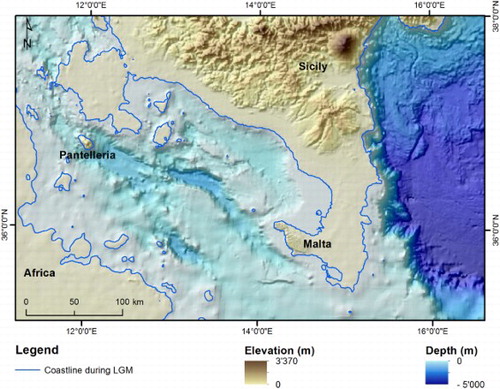
Our research was focused upon sectors of the Maltese Archipelago, that is Malta, Comino and their submarine reaches, to produce an integrated geomorphological map at 1:25,000. Sea level changes have greatly influenced Maltese continental shelf geomorphology: its portion shallower than ca. −130 m emerged during the sea level lowstands, which occurred during the last glacial cycle and was modelled by subaerial processes (CitationFoglini et al., 2016; CitationMicallef et al., 2013). This palaeo-landscape was progressively drowned by post-glacial sea level rise and terrestrial palaeo-landforms are still well preserved on the present seafloor (). The combination of alternating subaerial and marine conditions, and related geological and structural processes, is responsible for the origin of the high diversity of seafloor landforms, some of them relict and others still active today.
Figure 1. Palaeogeography of the Maltese archipelago during the LGM.
2. Regional setting
The Maltese archipelago, located in the Sicily Channel on the Malta Plateau (SE Sicily; (A)) is mainly constituted by Oligo-Miocene marine sedimentary units grouped into five geological formations (Fm) (Oil Exploration Directorate, Citation1993). These are the Lower Coralline Limestone Formation (Chattian), Globigerina Limestone Fm. (Late Chattian-Langhian), Blue Clay Fm. (Serravallian-Tortonian), Greensand Fm. (Tortonian) and Upper Coralline Limestone Fm. (Tortonian-Early Messinian). The oldest and the youngest formations consist of bioclastic bedded limestones, whereas the Globigerina Limestone Fm. consists of biocalcarenites, the Blue Clay Fm. of silty marlstones which are seldom capped by sands and clays (CitationBaldassini & Di Stefano, 2017; CitationPedley, Clarke, & Galea, 2002). Among the Quaternary deposits, a sequence of vertebrate remains, Pleistocene in age, was found in Ghar Dalam cave that witness the formation of land connections between the Maltese archipelago and Sicily during sea level lowstands of the last glacial cycle (CitationHunt, 1997).
Figure 2. (A) Geographic and tectonic setting of the Maltese archipelago within the Mediterranean Sea. (B) Geological setting of the Maltese Islands and bathymetry surrounding the archipelago (Oil Exploration Directorate, 1993).
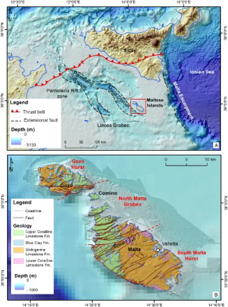
Two fault systems cross the islands: the most ancient is WSW-ENE-oriented, was active since early Miocene and is responsible for a horst and graben structure. The western continental shelf is influenced by this geological setting, where the horsts characterising the terrestrial portion of the area prolong on the shelf. The Great Fault is the most important and known fault of this structural trend, bounding the study area southward.
The most recent system was active in late Miocene – early Pliocene (CitationReuther & Eisbacher, 1985); it trends NW-SE parallel to the Pantelleria Rift controlling the morphology of the Archipelago’s northern and southern coasts, as well as the prominent submerged escarpment running parallel to the eastern coasts of Malta (CitationDart, Bosence, & McClay, 1993; CitationIllies, 1981; CitationJongsma, van Hinte, & Woodside, 1985).
The Maltese Islands are characterised by a Mediterranean temperate climate, with hot and dry summers (mean temperature 27°C), autumn, spring and winter are relatively humid, with short and mild winters (mean temperature of 12°C) and an annual precipitation of about 500 mm (Malta International Airport Meteorological Office). The predominant wind is the NW-blowing Mistral, which drives in the same direction as the wave motion. The offshore wave height that is exceeded for less than 10% of the time is about 2.1 m annually and 1.75 m for the summer period (CitationMalta Maritime Authority, 2003). In this framework, August is the mildest month, with over 60% of wave heights being between 0 and 0.5 m. Finally, the tidal range in Malta is within few centimetres (http://www.ioc-sealevelmonitoring.org/).
3. Materials and methods
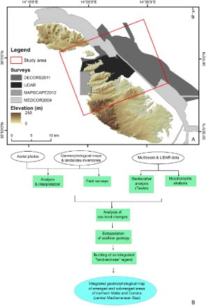
We exploited and analysed high-resolution (2 m) digital elevation models of multibeam bathymetry and LiDAR land elevation and acoustic backscatter images of the continental shelf ((A)). The research included the following analyses, summarised in the flow diagram ():
field surveys and interpretation of aerial photos (2012), taken from an altitude of 3078 m with a spatial resolution of 15 cm (Malta Planning Authority – MPA);
morphometric analysis of the bathymetry, for the identification of any subtle variations in seafloor morphology and to assist geomorphological interpretation;
texture analysis of the acoustic backscatter image, to automatically classify the type of sediment covering the seafloor and identify any benthic habitat occurrence (CitationBlondel, Prampolini, & Foglini, 2015).
Through geomorphological interpretation and comparison with seafloor maps available in the literature (CitationMicallef et al., 2012, Citation2013), seafloor substrate and morphology were inferred for the areas surveyed through bathymetric LiDAR where no acoustic backscatter data were available.
Figure 3. (A) Spatial coverage of bathymetric and LiDAR surveys and location of the study area; (B) flow diagram of the research phases.
The outputs were stored in a geographical information system for the representation of geomorphological features. Symbols follow the guidelines of the Geological Survey of Italy (CitationGruppo di Lavoro per la Cartografia Geomorfologica, 1994) and are based on the new legend for coastal geomorphology proposed by the Working Group for the Coastal Geomorphology of the Italian Association of Physical Geography and Geomorphology (CitationMastronuzzi et al., in press). Since the land- and sea-scapes are interrelated, the submerged landforms of terrestrial origin were represented with the same symbols as their on-land homologues, but with different tones. This enabled us to highlight the continuity of landforms above and below the present day sea level. With regards to mass movements, the emerged portions of block slides have been considered active by CitationDevoto et al. (2012) and CitationMantovani et al. (2013); any submerged landslide deposit has been considered inactive, since there are no monitoring data available. Finally, deposits due to earth flows/slides have been considered inactive, since they show recent activity just for areas not mappable at 1:25,000 scale.
4. The geomorphological map
The Main Map comprises a geographic and geodynamic setting of the study area, as well as a palaeo-geographic reconstruction of the Sicily Channel during the Last Glacial Maximum (LGM) and an overview of the elevation of the Maltese archipelago and surrounding bathymetry. The geomorphological map is draped over the digital terrain model, with the legend located on the left-hand side of the plate. At its bottom a NW-SE-oriented geological section and a map of the marine benthic habitats are presented.
4.1. Structural elements and landforms
Both on land and on the seafloor, a broad variety of geomorphological features occurs with significant differences between the eastern and the western sectors, mostly ascribable to the outcropping lithological units (CitationAlexander, 1988).
On Malta, the geological succession shows a 4° tilt towards the NE, forming higher altitudes on the western side. This setting favoured the erosion of the younger formations on the eastern side of the study area, while almost the entire sequence outcrops on the western side. The two fault systems are responsible for the orientation of ridges, valleys and structural scarps across the island and on the continental shelf that is wider on the eastern rather than on the western side of the islands.
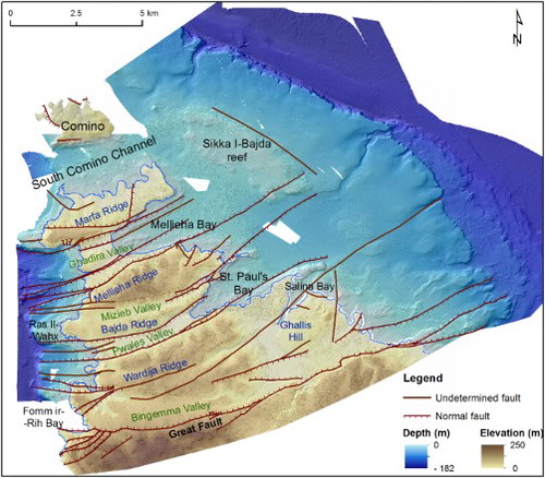
Limestone plateaus and ridges are limited by vertical structural cliffs whose orientation is locally controlled by the tectonic lineaments and often coincide with fault planes. Examples are the cliffs in the northern side of Ghajn Tuffieha Bay or along the southern side of Fomm Ir-Rih Bay, where the Great Fault creates an impressive plunging limestone cliff. These tectonic structures often bring into contact lithological units with different uniaxial rock strength causing differential erosion (e.g. limestones vs. marls). Also the orientation of the submerged plateaus and scarps is due to the structural setting, such as the NW-SE-oriented scarp located offshore the eastern coast of the archipelago. Relief is controlled by the occurrence of faults of both systems: an example is the Sikka I-Bajda reef – located on the eastern continental shelf, offshore Marfa Ridge and St. Paul’s Island – that is bounded by faults perpendicular to each other (). Finally, the horst and graben pattern influence the drainage pattern and the spatial distribution of landslides.
Figure 4. Structural sketch map of northern Malta and Comino.
4.2. Coastal landforms
Low-lying coasts dominate the northern and eastern coasts of Malta (CitationBiolchi et al., 2016b), such as at Marfa Ridge, between Qawra and the Great Fault and along the southern part of Comino. There, the coast is composed of bedded Coralline Limestones gently sloping towards the sea with a dip of 5° ((B)).
Figure 5. Types of coast occurring along northern Malta and Comino: (A) plunging cliffs, caves and sloping coasts occurring in Comino; (B) sloping coast in Upper Coralline Limestone at Marfa Ridge; (C) shore platform at Blata I-Bajda; (D) plunging cliff at Fomm ir-Rih; (E) scree at Ras in-Niexfa; (F) pocket beach at Ghajn Tuffieha Bay.
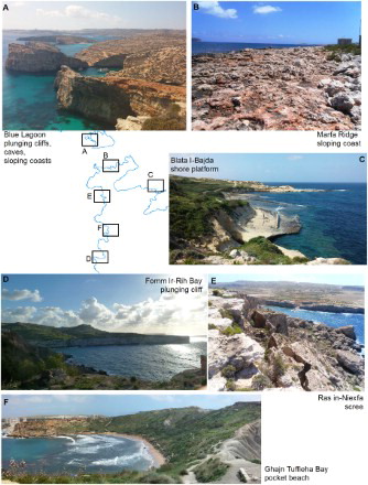
Shore platforms located at sea level and often submerged during storm events occur along the north-eastern coast, for example at Blata I-Bajda ((C)), and on the western side of Malta, at Gnejna Bay. They comprise Globigerina Limestone Fm. and developed mainly along strata surfaces that acted as preferential paths for marine erosion.
The western and south-western coasts consist of either Lower or Upper Coralline Limestone and are dominated by plunging cliffs ((D); CitationBiolchi et al., 2016b), as is the eastern coast of Comino, which is entirely composed of plunging cliffs in Upper Coralline Limestone characterised by marine notches ((A); CitationFurlani et al., in press). Extensive screes (called rdum by locals) are composed by Upper Coralline Limestone blocks lying on marlstones and claystones of the Blue Clay Fm. and are peculiar to the north-eastern and western coasts ((E)).
Pocket beaches alternate headlands and are mainly made of sandy deposits ((F)). Other coastal features, such as tidal notches, sea stacks, arches and caves occur mainly along the western coast (CitationBiolchi et al., 2016b). Along the eastern coast of Malta and Comino, large boulder deposits ascribed to extreme wave events have been described by CitationBiolchi et al. (2016a) and CitationMottershead, Bray, Soar, and Farres (2014, Citation2015).
CitationFurlani et al. (2013) and CitationLambeck et al. (2011) reported that sea level was 130 m lower than the present day during the LGM and that the Maltese archipelago has been tectonically stable since the Last Interglacial. It is probable that the long and continuous structural escarpment with a slope gradient of ∼35° and located about 7 km offshore of the east coast of Malta acted as a coastal cliff at that time. Different levels of marine terraces interpreted as relict shore platforms occur downslope of this escarpment, from St. Paul’s Island to the Great Fault, and on the west, related to the Marfa Ridge and Ras Il-Wahx promontories. The landward limit of these palaeo-shore platforms represent the highest sea level at the time of their formation (CitationAnderson, Densmore, & Ellis, 1999; CitationStokes & García, 2009). The presence of palaeo-shore platforms at different depths down to −130 m may reflect episodes of sea level stillstand that occurred during the sea level fall between 125 kyr ago and its culmination during the LGM (ca. 21 kyr ago) and during the post-glacial sea-level rise.
4.3. Fluvial landforms
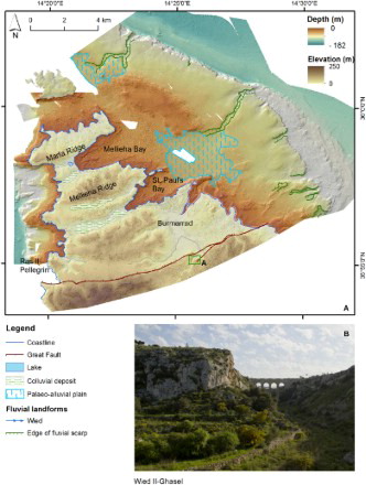
The main fluvial landforms consist of valleys carved within limestone bedrock forming a network of gorges mainly SW-NE-oriented, while minor streams running downslope on the ridges in a NW-SE direction. They are controlled both by the WSW-ENE fault system and the above-mentioned tilting (CitationAlexander, 1988). Currently the valleys on land are dry and host ephemeral streams (wied). Both a scarce amount of annual precipitation and the presence of persistent discontinuities in rock masses prevent the development of a permanent hydrography. The valleys now observable are bounded by sub-vertical fluvial scarps in rock and are filled by a shallow layer of soil (), mainly composed by sands, clays and terra rossa, and exploited for cultivation. The terrestrial valleys continue on the eastern continental shelf with the same orientation to reach and incise the main escarpment located at 75–90 m of depth. They have a sinuous to meandering pattern varying from 100 m to 4 km (CitationFoglini et al., 2016; CitationMicallef et al., 2013); they are filled by fine to medium sand alternating with coarse sand and gravel. The submerged channels are interpreted as relict fluvial valleys: they are the results of fluvial processes that developed during different stages of the sea level fall (CitationVan Heijst & Postma, 2001), when more humid conditions allowed the watercourses to cut the gorges and deposit the sediments. Thanks to the extremely limited supply of terrestrial sediments, the channels were not buried and remain clearly visible on the seafloor.
Figure 6. Sketch of emerged and submerged fluvial landforms and deposits (A) and detail of Wied Il-Ghasel (B). location shown be the green square in frame A.
Flat areas characterised by ripples of fine sediments on the eastern shelf are interpreted as palaeo-alluvial plains. Since they are located in graben areas, bounded by WSW-ENE-oriented faults, they can be interpreted as structurally controlled alluvial plains (e.g. Burmarrad plain). Gullies due to running water are frequent on Blue Clays (e.g. south of Il-Qarraba), while colluvial deposits and alluvial fans are common at the foot of the horst scarps.
4.4. Karst landforms
Karst features are well developed in both Upper and Lower Coralline Limestone formations. Karst pavements and small-scale features affect plateau surfaces and sloping coasts. Submerged bedrock outcrops are located near shore or in the mid shelf and present rugged surfaces. The widest one – known as Sikka I-Bajda reef – is located east of Marfa Ridge and St. Paul’s Island within a depth range between −30 and −44 m ((C)). The outcrops have been interpreted as Coralline Limestone palaeo-karst pavements shaped in a subaerial environment during past sea level lowstands.
Caves are common and mainly developed in both limestone formations: they characterise the cliffs of Mellieha Ridge and Bajda Ridge in the hinterland, and occur also at Bingemma Gap, having an important role for geo-archaeological investigations (CitationHunt, 1997).
Few sinkholes occur on the Upper Coralline Limestone plateaus of the northern area of Malta. They are probably Quaternary in age (CitationGalve et al., 2015; CitationSoldati, Tonelli, & Galve, 2013) and their formation is due to both solution and roof cave collapses (solution sinkholes and bedrock collapse sinkholes respectively, according to CitationGutiérrez, Parise, De Waele, & Jourde, 2014; (A,B)). A number of bedrock collapse sinkholes also occur on the continental shelf: five of them are hosted on Sikka Il-Bajda reef. They have diameters ranging between 60 and 270 m, are bounded by sub-vertical walls and are characterised by a flat and smooth bottom of fine to medium sand. They witness a past emergence of the limestone reef, when the sea level was lower and it was modelled by karst processes.
4.5. Gravity-induced landforms
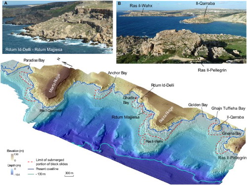
Extensive block accumulations are widespread along the NW coast of Malta (CitationDevoto et al., 2012). They witness the presence of extensive slow-moving landslides – rock spreads and block slides – which are generated mainly by the opposite geotechnical properties of the resistant Upper Coralline Limestone and the underlying ductile Blue Clays. Rock spreads cause the development of trenches and the generation and enlargement of persistent tension cracks, which can exceed 200 m in length. Together with the structural discontinuities, they cause the detachment of hundreds of limestone boulders from the plateau cliffs. Rock spreads evolve into block slides when the detached or lowered limestone blocks tilt and move slowly downhill covering extensive underlying clayey slopes (CitationDevoto et al., 2013a).
The accumulations of the displaced blocks continue below sea level up to a distance of 700 m (e.g. offshore Ras Il-Wahx) from the coastline and a maximum depth of −40 m (e.g. offshore Anchor Bay) (). The emerged and submerged portions of these block slides constitute a single slope-failure deposit. Hence, the terrestrial parts of these landslides constitute just one-third of the total runout and have been largely investigated by CitationMagri, Mantovani, Pasuto, and Soldati (2008), CitationMantovani et al. (2013), CitationDevoto et al. (2012, Citation2013a, Citation2013b, Citation2015) and CitationPiacentini et al. (2015). They showed that block slides occurring along the NW coast of Malta are active and move with different trends and rates (CitationMantovani et al., 2016). Slow-moving landslides are not very common in the eastern part of Malta, although they affect some coastal areas of Xemxija Bay (CitationPanzera, D’Amico, Lotteri, Galea, & Lombardo, 2012), Ras Il-Grieb and Mellieha Bay. Limited block slides and rock fall deposits can also be found along the eastern coast of Comino. The submarine parts of the described landslides, whose state of activity is unknown, were described in CitationFoglini et al. (2016) and CitationSoldati, Devoto, Prampolini and Pasuto (in press). Outstanding examples of block slides prolonging on the seafloor are those located at Anchor Bay, along the stretch of coast between Rdum id-Delli and Ras Il-Wahx (the most prominent block slide deposit) and Il-Qarraba ((A,B)). The onset of these landslides seems to have occurred in a subaerial environment, during the last glacial cycle, and successively sealed by the post-glacial sea level rise, according to recent cosmogenic ray exposure dating reported by CitationSoldati, Barrows, and Prampolini (2016).
Evidence of rock fall deposits at the foot of the cliffs in Coralline Limestone (both on land and on the seafloor) and of shallow earth flows/slides affecting the Blue Clay slopes are common. Most of them can be considered as collateral movements due to rock spreads and block slides (CitationPasuto & Soldati, 2013).
4.6. Marine landforms
The features related to marine processes have been modelled during and after the post-glacial marine transgression. In particular, the seafloor located downslope of the eastern escarpment is covered by fine to medium sand constituting hemipelagic and contour deposits (mound drift) shaped by bottom currents. On the eastern continental shelf, flat areas located offshore St. Paul’s Bay and offshore Comino are covered by fine to medium sand that is shaped in ripples by bottom currents.
Figure 7. (A) Ta' Randa solution sinkhole; (B) Il-Mansap bedrock collapse sinkhole; (C) submerged bedrock collapse sinkholes located on Sikka Il-Bajda reef.
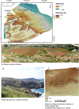
Figure 8. 3D view of the north-western coast Malta affected by landslides prolonging on the seafloor (modified after Soldati et al., in press): (A) southern side of Rdum Id-Delli and Rdum Majjiesa block slides; (B) view of Ras Il-Wahx and Il-Qarraba block slides from Ras Il-Pellegrin promontory.
4.7. Habitats
The substrate of the eastern continental shelf is often characterised by wide maërl beds extending from 55 to 90 m of depth ca. (CitationBorg et al., 1998; CitationSciberras et al., 2009). In shallower waters on both east and west coasts, the hard substrates host seagrass meadows and matte (Posidonia oceanica and Cymodocea nodosa) reaching a maximum depth of ca. −55 m (CitationBorg et al., 1998; Borg, Rowden, Attrill, Schembri, & Jones, Citation2009; CitationMicallef et al., 2012). Because of the above described habitats, the portion of continental shelf offshore the eastern coasts of Malta is part of the Natura 2000 network as a Special Area of Conservation – International Importance (Zona fil-Bahar fil-Grigal ta’ Malta – MT105 sheet). The western continental shelf between Ras Il-Wahx and Fomm ir-Rih Bay is part of the Natura 2000 sites network due to the importance of seagrass meadow and associated biological assemblages (MT101 sheet on MPA website).
4.8. Anthropogenic features
The northern area of Malta is the less populated and urbanised part of the island. Mellieha and Bugibba are the largest towns and are located on the eastern side, where most of the human activities are concentrated. The island of Comino is nearly uninhabited and hosts historic sites (St. Mary’s Tower and Battery) and several tourist facilities at Blue Lagoon, St. Mary's Bay and at St. Nicholas inlet.
The most invasive anthropogenic structure on Malta is a huge municipal refuse dump reaching an elevation of ca. 100 m a.s.l. located in proximity of Ghar Hills. A total of 10 quarries are scattered across the northern sector, excavating mainly Upper Coralline Limestone. Two quarries are still active and excavate Lower Coralline Limestone in proximity of the Great Fault.
Generally, rural, historical and military heritage of the area is closely related to the landscape (e.g. shore platforms in Globigerina Limestone are often exploited as salt pans). These features include ancient towers, barracks, cart-ruts, long rubble (drystone) walls, farmhouses, natural caves and numerous stone huts (CitationCoratza, Bruschi, Piacentini, Saliba, & Soldati, 2011). The most relevant human activity in the study area is related to agriculture: cultivated areas and terraced fields are typical landscapes of the hinterland.
Regarding the seafloor, just west of Cirkewwa two wrecks of about 52 and 32 m of length were recognised at a depth of ca. 30 m – the tug boat Rozi and the minesweeper guard ship P29 – sunk to create attractions for divers.
5. Conclusions
The integration of terrestrial and marine investigations was crucial for a better comprehension of the geomorphological evolution of the study area. The Main Map shows that most of the landforms characterising the seafloor developed in a subaerial environment and were successively drowned by post-glacial sea level rise. Significant geomorphological features, such as landslide deposits, are now partly submerged and partly emerged. Similarly, the occurrence of bedrock collapse sinkholes both on land and on the seafloor is of particular interest, especially due to their high density on the submerged Sikka I-Bajda reef and good preservation from marine processes.
The Main Map provides a detailed spatial distribution of underwater landforms and deposits and may encourage local authorities and research groups to undertake further investigations on the palaeo-environmental conditions of their creation, and dating analyses in order to define the temporal interval of landform evolution. This study may also constitute the basis for hazard assessment both along the coasts – where analyses have been carried out and are still on-going – and in submarine areas, where infrastructure (such as cables and pipelines) may be located.
Software
CARIS HIPS and SIPS was used to process bathymetric and backscatter data, Benthic Terrain Modeller for morphometric analysis of the bathymetry and TexAn (implemented by Prof. Ph. Blondel, University of Bath, UK) for seafloor backscatter classification. The map and the layout were produced using Esri ArcGIS and Adobe InDesign.
Integrated geomorphological map of emerged and submerged areas of northern Malta and Comino (central Mediterranean Sea).pdf
Download PDF (28.5 MB)Acknowledgements
The authors are grateful to the Malta Planning Agency (MPA) for providing bathymetric and LiDAR data and aerial photos, to the R/V Urania and its crew for the bathymetric data collection, to Prof. Philippe Blondel for the collaboration and perform the texture analysis on the backscatter datasets and to Dr Marco Taviani for providing data and suggestions to improve the manuscript.
Disclosure statement
No potential conflict of interest was reported by the authors.
Additional information
Funding
Related Research Data
References
- Alexander, D. (1988). A review of the physical geography of Malta and its significance for tectonic geomorphology. Quaternary Science Reviews, 7(1), 41–53. 10.1016/0277-3791(88)90092-3
- Anderson, R. S., Densmore, A. L., & Ellis, M. A. (1999). The generation and degradation of marine terraces. Basin Research, 11, 7–19.
- Baldassini, N., & Di Stefano, A. (2017). Stratigraphic features of the Maltese archipelago: A synthesis. Natural Hazards, 86(2), 203–231. 10.1007/s11069-016-2334-9
- Biolchi, S., Furlani, S., Antonioli, F., Baldassini, N., Causon Deguara, J., Devoto, … Scicchitano, G. (2016a). Boulder accumulations related to extreme wave events on the eastern coast of Malta. Natural Hazards and Earth System Sciences, 16, 737–756. 10.5194/nhess-16-737-2016
- Biolchi, S., Furlani, S., Devoto, S., Gauci, R., Castaldini, D., & Soldati, M. (2016b). Geomorphological identification, classification and spatial distribution of coastal landforms of Malta (Mediterranean Sea). Journal of Maps, 12(1), 87–99. doi: 10.1080/17445647.2014.984001
- Blondel, P., Prampolini, M., & Foglini, F. (2015). Acoustic textures and multibeam mapping of shallow marine habitats – examples from Eastern Malta. Proceedings of the Institute of Acoustics, 37(1), 250–257.
- Borg, J. A., Howege, H. M., Lanfranco, E., Micallef, S. A., Mifsud, C., & Schembri, P. J. (1998). The macrobenthic species of the infralittoral to circalittoral transition zone off the northeastern coast of Malta (central Mediterranean). Xjenza, 3(1), 16–24.
- Borg, J. A., Rowden, A. A., Attrill, M. J., Schembri, P. J., & Jones, M. B. (2009). Occurrence and distribution of different bed types of seagrass Posidonia oceanica around the Maltese Islands. Mediterranean Marine Science, 10(2), 45–61. doi: 10.12681/mms.108
- Coratza, P., Bruschi, V. M., Piacentini, D., Saliba, D., & Soldati, M. (2011). Recognition and assessment of geomorphosites in Malta at the Il-Majjistral Nature and History Park. Geoheritage, 3(3), 175–185. doi: 10.1007/s12371-011-0034-0
- Dart, C. J., Bosence, D. W. J., & McClay, K. R. (1993). Stratigraphy and structure of the Maltese graben system. Journal of Geological Society of London, 150(6), 1153–1166. doi: 10.1144/gsjgs.150.6.1153
- De Jongh, C., & van Opstal, H. (2012). Coast-Map-IO TopoBathy Database. (Report Pilot Project). CARIS BV, p. 6.
- Devoto, S., Biolchi, S., Bruschi, V. M., Furlani, S., Mantovani, M., Piacentini, D., … Soldati, M. (2012). Geomorphological map of the NW coast of the Island of Malta (Mediterranean Sea). Journal of Maps, 8(1), 33–40. doi: 10.1080/17445647.2012.668425
- Devoto, S., Biolchi, S., Bruschi, V. M., González Díez, A., Mantovani, M., Pasuto, A., … Soldati, M. (2013a). Landslides along the north-west coast of the island of Malta. In C. Margottini, P. Canuti, & K. Sassa (Eds.), Landslide science and practice: Landslide inventory and susceptibility and hazard zoning (Vol. 1, pp. 57–63). Berlin: Springer-Verlag.
- Devoto, S., Forte, E., Mantovani, M., Mocnik, A., Pasuto, A., Piacentini, D., & Soldati, M. (2013b). Integrated monitoring of lateral spreading phenomena along the north-west coast of the island of Malta. In C. Margottini, P. Canuti, & K. Sassa (Eds.), Landslide science and practice: Early warning, instrumentation and monitoring (Vol. 2, pp. 235–241). Berlin: Springer-Verlag.
- Devoto, S., Mantovani, M., Pasuto, A., Piacentini, D., & Soldati, M. (2015). Long-term monitoring to support landslide inventory maps: The case of the north-western coast of the Island of Malta. In G. Lollino, D. Giordan, G. B. Crosta, J. Corominas, R. Azzam, J. Wasowski, & N. Sciarra (Eds.), Engineering geology for society and territory – volume 2: Landslide processes (pp. 1307–1310). Switzerland: Springer International Publishing.
- Foglini, F., Prampolini, M., Micallef, A., Angeletti, L., Vandelli, V., Deidun, A., … Taviani, M. (2016). Late Quaternary coastal landscape morphology and evolution of the Maltese Islands (Mediterranean Sea) reconstructed from high-resolution seafloor data. In J. Harff, G. Bailey, & L. Lüth (Eds.), Geology and Archaeology: Submerged landscapes of the continental shelf. London: Geological Society, Special Publication, 411(1), 77–95.
- Furlani, S., Antonioli, F., Biolchi, S., Gambin, T., Gauci, R., Lo Presti, V., … Sulli, A. (2013). Holocene sea level change in Malta. Quaternary International, 288, 146–157. doi: 10.1016/j.quaint.2012.02.038
- Furlani, S., Antonioli, F., Gambin, T., Gauci, R., Ninfo, A., Zavagno, E., … Cucchi, F. (in press). Marine notches in the Maltese islands (central Mediterranean Sea). Quaternary International. doi: 10.1016/j.quaint.2016.03.004
- Galve, J. P., Tonelli, C., Gutiérrez, F., Lugli, S., Vescogni, A., & Soldati, M. (2015). New insights into the genesis of the Miocene collapse structures of the island of Gozo (Malta, central Mediterranean Sea). Journal of the Geological Society, 172, 336–348. doi: 10.1144/jgs2014-074
- Gruppo di Lavoro per la Cartografia Geomorfologica. (1994). Carta geomorfologica d’Italia – 1:50.000, guida al rilevamento. Servizio Geologico Nazionale, Quaderni Serie III, 4, 1–42.
- Gutiérrez, F., Parise, M., De Waele, J., & Jourde, H. (2014). A review on natural and human-induced geohazards and impacts in karst. Earth-Science Reviews, 138, 61–88. doi: 10.1016/j.earscirev.2014.08.002
- Harff, J., Bailey, G., & Luth, F. (2016). Geology and archaeology: Submerged landscapes of the continental shelf. London: Geological Society Special Publications.
- Hunt, C. O. (1997). Quaternary deposits in Maltese Islands: A microcosm of environmental change in Mediterranean lands. GeoJournal, 41(2), 101–109. doi: 10.1023/A:1006824605544
- Illies, J. H. (1981). Graben formation-the Maltese Islands-a case history. Tectonophysics, 73, 151–168. doi: 10.1016/0040-1951(81)90182-7
- Jongsma, D., van Hinte, J. E., & Woodside, J. M. (1985). Geologic structure and neotectonics of the North African Continental Margin south of Sicily. Marine and Petroleum Geology, 2(2), 156–179. doi: 10.1016/0264-8172(85)90005-4
- Kerr, S., Johnson, K., & Side, J. C. (2014). Planning at the edge: Integrating across the land sea divide. Marine Policy, 47, 118–125. doi: 10.1016/j.marpol.2014.01.023
- Lambeck, K., Antonioli, F., Anzidei, M., Ferranti, L., Leoni, G., & Silenzi, S. (2011). Sea level change along the Italian coast during the Holocene and projections for the future. Quaternary International, 232, 250–257. doi: 10.1016/j.quaint.2010.04.026
- Magri, O., Mantovani, M., Pasuto, A., & Soldati, M. (2008). Geomorphological investigation and monitoring of lateral spreading along the north-west coast of Malta. Geografia Fisica e Dinamica Quaternaria, 31(2), 171–180.
- Malta Maritime Authority. (2003). Malta significant wave height study. Main report. Malta: Scott Wilson Kirkpatrick and Co. Ltd., p. 43.
- Mantovani, M., Devoto, S., Forte, E., Mocnik, A., Pasuto, A., Piacentini, D., & Soldati, M. (2013). A multidisciplinary approach for rock spreading and block sliding investigation in the north-western coast of Malta. Landslides, 10(5), 611–622. doi: 10.1007/s10346-012-0347-3
- Mantovani, M., Devoto, S., Piacentini, D., Prampolini, M., Soldati, M., & Pasuto, A. (2016). Advanced SAR interferometric analysis to support geomorphological interpretation of slow-moving coastal landslides (Malta, Mediterranean Sea). Remote Sensing, 8, 443–461. doi: 10.3390/rs8060443
- Mastronuzzi, G., Aringoli, D., Aucelli, P. P. C., Baldassarre, M. A., Bellotti, P., Bini, M., … Valente, A. (in press). The geomorphological map of the Italian coast: From a descriptive to a morphodynamic approach. Geografia Fisica e Dinamica Quaternaria.
- Micallef, A., Foglini, F., Le Bas, T., Angeletti, L., Maselli, V., Pasuto, A., & Taviani, M. (2013). The submerged paleolandscape of the Maltese Islands: Morphology evolution and relation to Quaternary environmental change. Marine Geology, 335, 129–147. doi: 10.1016/j.margeo.2012.10.017
- Micallef, A., Le Bas, T.P., Huvenne, V.A.I., Blondel, P., Hühnerbach, V., & Deidun, A. (2012). A multi-method approach for benthic habitat mapping of shallow coastal areas with high-resolution multibeam data. Continental Shelf Research, 39–40, 14–26. doi: 10.1016/j.csr.2012.03.008
- Miccadei, E., Mascioli, F., Orrù, P., Piacentini, T., & Puliga, G. (2011). Late Quaternary palaeolandscape of submerged inner continental shelf areas of Tremiti Islands archipelago (Northern Puglia). Geografia Fisica e Dinamica Quaternaria, 34(2), 223–234. doi: 10.4461/GFDQ.2011.34.20
- Miccadei, E., Mascioli, F., & Piacentini, T. (2011). Quaternary geomorphological evolution of the Tremiti Islands (Puglia, Italy). Quaternary International, 233, 3–15. doi: 1016/j.quaint.2010.04.028
- Miccadei, E., Orrù, P., Piacentini, T., Mascioli, F., & Puliga, G. (2012). Geomorphological map of the Tremiti Islands (Puglia, Southern Adriatic Sea, Italy), scale 1:15,000. Journal of Maps, 8(1), 74–87. doi: 10.1080/17445647.2012.668765
- Mottershead, D., Bray, M., Soar, P., & Farres, P. J. (2014). Extreme wave events in the central Mediterranean: Geomorphic evidence of tsunami on the Maltese Islands. Zeitschrift fűr Geomorphologie, 58(3), 385–411. doi: 10.1127/0372-8854/2014/0129
- Mottershead, D., Bray, M., Soar, P., & Farres, P. J. (2015). Characterisation of erosional features associated with tsunami terrains on rocky coasts of the Maltese islands. Earth Surface Processes and Landforms, 40(15), 2093–2111. doi: 10.1002/esp.3784
- Oil Exploration Directorate. (1993). Geological map of the Maltese Islands. Valletta: Office of the Prime Minister.
- Panzera, F., D’Amico, S., Lotteri, A., Galea, P., & Lombardo, G. (2012). Seismic site response of unstable steep slope using noise measurements: The case study of Xemxija Bay area, Malta. Natural Hazards and Earth System Science, 12, 3421–3431. doi: 10.5194/nhess-12-3421-2012
- Parrott, D. R., Todd, B. J., Shaw, J., Hughes Clarke, J. E., Griffin, J., MacGowan, B., Lamplugh, M., & Webster T. (2008). Integration of multibeam bathymetry and LiDAR surveys of the Bay of Fundy, Canada. Proceedings of the Canadian hydrographic conference and national surveyors conference 2008, Paper 6-2, 1–15.
- Pasuto, A., & Soldati, M. (2013). Lateral spreading. In J. F. Shroder (Ed.), Treatise on geomorphology (Vol. 7, pp. 239–248). San Diego, CA: Academic Press.
- Pedley, H. M., Clarke, M. H., & Galea, P. (2002). Limestone isles in a crystal Sea: The geology of the Maltese Islands. San Gwann (Malta): Publisher Enterprises Group.
- Piacentini D., Devoto S., Mantovani M., Pasuto A., Prampolini M., & Soldati M. (2015). Landslide susceptibility modeling assisted by persistent scatterers interferometry (PSI): An example from the northwestern coast of Malta. Natural Hazards, 78(1), 681–697. doi: 10.1007/s11069-015-1740-8
- Reuther, C. D., & Eisbacher, G. H. (1985). Pantelleria rift – crustal extension in a convergent intraplate setting. Geologische Rundschau, 74(3), 585–597. doi: 10.1007/BF01821214
- Sciberras, M., Rizzo, M., Mifsud, J. R., Camilleri, K., Borg, J. A., Lanfranco, E., & Schembri, P. J. (2009). Habitat structure and biological characteristics of a maerl bed off the northeastern coast of the Maltese Islands (central Mediterranean). Marine Biodiversity, 39(4), 251–264. doi: 10.1007/s12526-009-0017-4
- Soldati, M., Barrows, T. T., & Prampolini, M. (2016). Landslides and sea level changes: Evidence of the complex geomorphological evolution of the NW coast of Malta from exposure dating using cosmogenic nuclides. Rendiconti Online Della Società Geologica Italiana, 40(1), 368. doi: 10.3301/ROL.2016.79
- Soldati, M., Devoto, S., Prampolini, M., & Pasuto, A. (in press). The spectacular landslide-controlled landscape of the northwestern coast of Malta. In R. Gauci & J. A. Schembri (Eds.), Landscapes and landforms of the Maltese Islands. World Geomorphological Landscapes, Springer.
- Soldati, M., Tonelli, C., & Galve, J. P. (2013). Geomorphological evolution of palaeosinkhole features in the Maltese archipelago (Mediterranean Sea). Geografia Fisica e Dinamica Quaternaria, 36(1), 189–198. doi: 10.4461/GFDQ.2013.36.16
- Stokes, M., & García, A. F. (2009). Late Quaternary landscape development along the Rancho Marino coastal range front (south-central Pacific Coast Ranges, California, USA). Journal of Quaternary Science, 24(7), 728–746. doi: 10.1002/jqs.1243
- Van Alphen, J. S. L. J., & Damoiseaux, M. A. (1989). A geomorphological map of the Dutch shoreface and adjacent part of the continental shelf. Geologie en Mijnbouw, 68(4), 433–443.
- Van Heijst, M. W. I. M., & Postma, G. (2001). Fluvial response to sea-level changes: A quantitative analogue, experimental approach. Basin Research, 13(3), 269–292. doi: 10.1046/j.1365-2117.2001.00149.x
- Westley, K., Quinn, R., Forsythe, W., Plets, R., Bell, T., Benetti, S., … Robinson, R. (2011). Mapping submerged landscapes using multibeam bathymetric data: A case study from the north coast of Ireland. International Journal of Nautical Archaeology, 40(1), 99–112. doi: 10.1111/j.1095-9270.2010.00272.x
- Websites
- Il-Majjistral Nature and History Park. Retrieved from http://mt.majjistral.org/home
- MPA website. Retrieved from https://mpa.org.mt/
- World Heritage Tentative List. Retrieved from http://whc.unesco.org/en/tentativelists/979/