
ABSTRACT
This paper presents a geomorphological analysis of the littoral zone of the Arosa-Pontevedra estuary mouth and identifies geomorphological units and categorizes them into morphogenetic systems. The different morphogenetic systems are used to establish a comprehensive evolutionary analysis, contrasting the depositional systems found in the continental littoral zone with the marine erosional systems (‘rasas’). The compiled cartography groups the geomorphological units into the following: the lithoestructural morphogenetic system with large-scale forms (domes, inselbergs, residual relief, etc.) and small-scale forms (gnammas, tafoni, channels, etc.); the littoral morphogenetic system comprised of marine (marine terraces, beaches, tidal bars, tombolos and coastal arrows), transition (marshes, lagoons and fan deltas) and eolian (dune systems) settings; the fluvial morphogenetic system with channelled (alluvial, flood plain and river terraces), transition (alluvial fans and alluvial cones) and sheet flood (pediments and glacis) systems; the gravitational morphogenetic system (colluvium); and the alteration morphogenetic system (sand-alteration).
1. Introduction
Estuaries, termed ‘rías’, are important morphological features along the coast of Galicia. Traditionally, these features were thought to originate from a combination of tectonic activity (the orientation of each ‘ría’ is a reflection of the dominant fractures exploited by streams) and sediment saturation caused by the presence of an earlier river valley. The morphology of the Arosa estuary, although suggestive of a similar origin, implies that it is not a typical tectonic estuary, but was rather formed in a large sedimentary basin with dimensions and a morphology different from nearby estuaries, creating a region known as the ‘mar de Arosa’ (CitationMartín - Serrano García, 1994b; CitationMartínez-Graña, 1994; CitationNonn, 1964; CitationSole Sabaris et al., 1983). These differences are addressed in later sections. This region incorporates several of the morphogenetic processes essential for analysing the evolutionary events that affected the riverbanks, as well as a sedimentary record and evidence for variations in local sea level (CitationMartínez-Grana, Boski, Goy, Zazo, & Dabrio, 2016; CitationMartínez-Graña et al., 2017), based on erosional levels lacking sediment deposits or marine terraces. This is particularly relevant because the acidic nature of the substratum has resulted in azoic deposits, which are especially important for geomorphological analysis. The Arosa estuary is considered a morphoestructural fossa generated during the Miocene–Pliocene epochs and bounded by two tectonic horsts that form the Barbanza peninsula to the north and the Castrove peninsula to the south. This complex displays a predominant NE-SW orientation that coincides with the axis of the Rias Bajas, influenced by late-Hercynian fracturing that was reactivated in post-alpine times and that resulted in neotectonic processes.
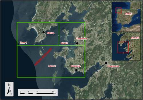
The primary purpose of this work is to perform a detailed geomorphological analysis to identify the different morphogenetic systems, the sequence of the processes and the relative chronologies for certain deposits (alluvial fans and dunes) and erosional features (marine terraces). The accompanying geomorphological map will assist in explaining the morphology and origin of the Arosa estuary and its distinction from the larger Rias Bajas ().
Figure 1. Study area (green) and zones.
1.1. Study area and orography
The Arosa estuary is located in the northwestern Iberian Peninsula and the southeast region of Galicia, forming part of the Rias Bajas. The northern margin of the Arosa estuary belongs to the province of La Coruña, while the southern margin resides in the province of Pontevedra.
This area has been subdivided into three zones with distinctive features () that have been denominated according to the names of the most important towns and place names. These zones are the Barbanza mountain range-Corrubedo-Puebla del Caramiñal (Zone 1), Arosa Island-Villanueva-Cambados (Zone 2) and the Grove-Castrove mountain range-Sangenjo zone (Zone 3).
Zone 1 corresponds to the Barbanza peninsula, a prominent coastal landform that belongs to the province of La Coruña and separates the Muros and Noya estuaries in the north from the Arosa estuary in the south. On the continent, the boundary is defined by the Ulla River, which discharges into the estuary head. In the Barbanza mountain range, we find abrupt, high relief where granitic bedrock outcrops in a dome morphology. Summit elevations decrease gradually from east to west, creating phased surfaces.
Zone 2 is located along the northern margin of the Pontevedra estuary. This zone is highlighted because it presents unique geomorphological features, such as the N-S orientation of its coast and an abundance of marine terraces, which result from the propensity of the Caldas de Reyes batholith to experience intense, differential weathering that generates surfaces of different elevations. This zone possesses a peneplain surface that hosts scattered, low-elevation granite outcrops. This large littoral plain allows intense differential erosion of the Caldas de Reyes batholith granite, which is easily weathered because of its mineralogy. This sector ((a)) includes prominent, high-elevation areas. The intense differential erosion present in this zone has generated large regions of sand production, a result of the physical weathering of the granitic bedrock, with fewer granitic areas of high elevation and residual relief. In general, this sector possesses the lowest relief and includes two areas of contrasting orography: the west sector, a plain with marine terrace sediments, and the east sector with abrupt granitic relief and tors (CitationMartín - Serrano García, 1994a; CitationMartínez-Graña, 2003).
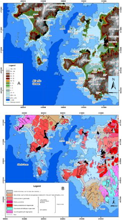
Figure 2. (A) Physiographic map showing the topography of the study area. (B) Geological map.
Zone 3 extends southward of the second zone. It constitutes a portion of the Castrove peninsula, a littoral horst that separates the grabens and comprises the Arosa and Pontevedra estuaries. Metamorphic bedrock is found in this zone, as well as overlapping morphogenetic fluvial and gravitational deposits (alluvial fans, glacis, pediments and colluvium), erosional surfaces (marine terraces, paleo-cliffs) and marine littoral deposits. Furthermore, this zone displays a more irregular relief than do zones 1 and 2. Here, relief is less pronounced and less geometrical (domatic intrusion), and does not show granitic morphologies. However, tors are present, including those of the Monte Xiradella in Grove.
The metamorphic substratum, which is abundant in this zone, confers a characteristic modelling, such that the main drainage network appears dendritic and radial in shape and flows north into the Arosa estuary and northwest into the Pontevedra estuary. This is quite different from the modelling that appears in the Barbanza mountain range, as in this zone the relief of Monte Castrove is more undulating, and contains fluvial deposits in the lower zones with several overlapping alluvial fans. The orography is less marked in comparison with the granitic modelling (higher resistance to weathering).
1.2. Geologic and tectonic setting
Galicia is located within the northwestern Hercinic range, termed Macizo Varisco. The Iberian orogenic belt is the result of a collision between several continental masses (currently northern and southern Europe, North America and Africa), which merged into the super-continent Pangaea. This collision occurred in the Devonian–Carboniferous periods, but in some areas occurred earlier and was not synchronous along the entire Hercinic range. Regional bedrock is organized by three collision phases, which each increased in the severity of folding. At both margins of the Rias Bajas, three distinct domains can be differentiated based on their petrographic features, degree of metamorphism, and structural and geotectonic characteristics ((b)). These domains are: (1) the Vigo-Pontevedra-Noya Complex (‘polymetamorphic graben’ or ‘blastomilonitic fossa’), which is formed by a polymetamorphic metasedimentary sequence and contains mica schists and gneisses originating in the Pre-Cambrian or Cambrian periods; (2) the migmatitic and granitic bedrock (‘Lage group’) (CitationBard, 1978), which can be subdivided into three regions – the ‘Esquisto–grauváquico’ region, formed by metasediments and sandstone, ‘El Rosal–La Lanzada’ region with two-mica schists; and ‘Villagarcia–Cuntis’ region, with two-mica alkaline feldspar granite; and 3) the post-cinematic (CitationArps, 1970) Late Carboniferous granitoid batholith that is defined by sharp, discordant contacts.
In Galicia, geotectonic complexes with deformations and metamorphisms are affected by magmatic episodes. In general, we can distinguish two clear morphoestructural lineations (CitationFlor, 1985): the northeast-southwest lineation, late-hercinic, which corresponds with the same orientation as the axes of the Rias Bajas. It must be taken into account that the Galician block is located in one of the zones closest to the Atlantic centre-oceanic dorsal of the Eurasian plate thus, it is not illogical to think about a relation between this direction and the faults created by the separation and subsequent movement that Europe suffered to the east and America to the west; and the north-south lineation that corresponds to the neogene fracture direction which is newer than the previous lineation. In the Arosa estuary the fractures with northeast to southwest and northeast to southeast directions are the predominant ((b)).
2. Methods and morphogenetic systems
The geomorphological analysis of the littoral zone of the Arosa-Pontevedra estuary is based on a detailed analysis of the recognizable geomorphological units and their grouping into morphogenetic systems. The different morphogenetic systems in the study area are analysed and described, using a global evolutionary approach, and the depositional systems identified in the continental littoral zone are compared with the erosional systems (polygenic surfaces without deposits). In order to produce the geomorphological map (see Main Map), the following steps were taken:
(1) preliminary photo-geologic interpretation, which is used to carry out the research and fieldwork. The aerial photography used for the analysis was Vuelo del Ejército del Aire, 1984, scale 1:30,000 I.G.N., Vuelo del Ejército del Aire, 1985, scale 1:18,000 I.G.N.; (2) fieldwork and collection of the structural and lithological data, in addition to a complete photographic documentary; and (3) the photo-interpretation is corrected and geo-referenced and the polygons and lines of the different backfills are digitized, generating a Digital Geomophological Map, scale 1:50,000. In the analysis of the relief a Digital Elevation Model (DEM) produced from Laser Imaging Detection and Ranging data (LIDAR) has been used (spatial resolution 5 m). In this map, the different Quaternary units are distinguished, which constitute morphogenetic deposits of the different depositional agents and are placed over the plutonic and metamorphic substrata that appear on the conventional geographical map.
In the Arosa estuary, geomorphological units have been identified that belong to the following morphogenetic systems:
2.1. Lithostructural morphogenetic system
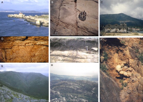
Lithology generates a specific and unique type of relief in the Galician littoral zone of the Arosa estuary, and characterizes the morphogenesis of the area. Here, a sequence of magmatic masses generated inselbergs, ballooning and other geometries, which are considered to be peni-original mixed forms that define constructive morpho-lithologies. These forms were later altered by external geologic processes, and define a lithological granite model with mixed forms (at different stages of erosion), or tors. The morphology associated with alteration can be divided according to spatial dimensions: large- and small-scale forms (). The large-scale forms can be found in two-mica granites and are termed domes or bornhardt. The most characteristic form, which comprises the sincinematic granite located at the north margin of the Arosa estruary, is the Monte Curota found on the Barbanza peninsula. It is a cupuliform domatic form located in higher zones, while on the hillsides of this same structure the process of alteration presents a greater evolutionary stage, generating a degraded dome or tor. The dominant joint pattern is orthogonal, curved and radial. It comprises a young relief, not very evolved, similar to what can be seen in the Pedras River channel where the union between the river and the granite is minimum and the profile of the river shows big slopes caused by the resistance of this granite to weathering and erosion. In general, we can end this section regarding large forms by stating that at the margins of the Arosa estuary we find evolutionary stages from the inferior end and generalized alteration (sand-alteration) in the central and littoral zones of the interior of the estuary. Farther away, we have tors and stony slopes on the more or less developed flanks of degraded domes, and dominant cupuliform morphologies that do not reach the extreme of the campaniform domes or crests in the elevated reliefs.
Figure 3. (A) Arosa Island lighthouse depicting horizontal decompression fractures that facilitate scale formation. (B) Nearly orthogonal, intersecting joints N-S/E-W. (C) Barbanza mountain range from Puebla del Caramiñal. (D) Decompression fractures with water circulation due to infiltration into Arosa Island. (E) Granites with decompression fractures and the overlying edaphic layer. (F) Contact between Caldas de Reyes late granite and metamorphic rocks near Foxos Beach. (G) Pedras River, with a large slope profile on the Barbanza mountain range. (H) Cupuliform granites and Corrubedo complex.
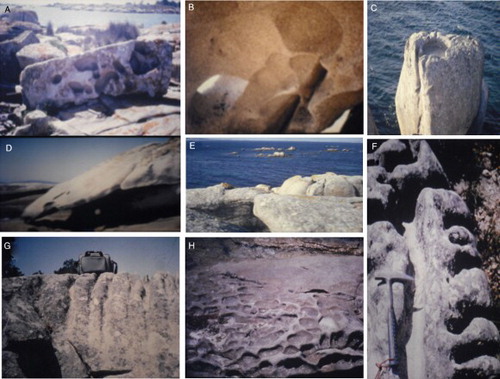
The small-scale forms () are superimposed over the large-scale forms, both of which are generated by shallow, subsurface processes. Gnamma form a shallow circular hole and depending on the evolutionary stage, may possess a drainage channel on one side. Tafoni comprise cavities located inside a larger granitic rock. The development of tafoni and to a lesser extent gnamma, is accelerated by haloclasty and the selective concentration of humidity. This process occurs due to meteoric disintegration, generating morphologies characteristic of wells of a nest or hive and which are also called honeycombing (CitationTwidale, 1982). In some areas, stratification can be observed because of the dense, parallel, subhorizontal joints that generate flagstones. The fragmentation of the granitic blocks has permitted landsliding, leaving behind towers in which one block remains suspended. These protrusions are minor structures and are termed overhanging walls. Finally, in several zones with very gentle slopes and where granite is uniformly altered, pavements are produced over horizontal planes that are very polished but have slight inflections and discontinuities where the granite inflects.
Figure 4. (A) Block with tafoni. (B) Tafoni honeycombing. (C) Armchair on Arosa Island. (D) Scale with tafoni. (E) Fractures. (F) and (G) Channels on granitic blocks. (H) Incipient gnammas.
2.2. Littoral morphogenetic system
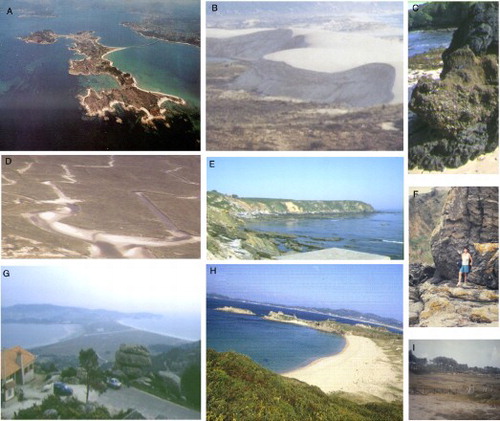
In this system, aquatic and terrestrial environments meet to form three environments: marine, transition and eolian (). In the marine environment, we can distinguish destructive and constructive processes. Constructive processes produce depositional forms or sediment accumulations that can be classified according to origin: allochtonen (from fluvial streams), para-native (from eolian processes and cliff erosion) and native (from biological activity). In this zone, we find beaches, tidal bars, tombolos and coastal arrows. Destructive processes, such as weathering, result in marine terraces (relict abrasion platforms later raised by tectonic processes) and more recent abrasion terraces. The relict abrasion platforms may be of marine origin or ancient polygenic surfaces exhumed by the erosive processes of the ocean (CitationMartínez-Graña, Goy, & Zazo, 2000). The transition environment holds marshes and lagoons where the settling of fine materials dominates because of cyclical flooding. There are three zones containing marshes of great importance: the southern zone of Corrubedo, where beaches and dune systems comprise a barrier island, creating the Corrubedo complex; the zone along the mouth of the river Umia; and the Grove-Umia Bay, where the larger-scale forms are located. The Flandrian transgression combined with the high volume of sediment travelling from the platform areas to the coastline formed the Corrubedo complex (CitationVilas Martín et al., 1991). In the eolian environment littoral dunes can host vegetation that decreases the mobility of sediments. Three types of dunes can be differentiated according to their age and vegetation: D1: vegetated dunes, originating from the middle Pleistocene; D2: semi-vegetated dunes, originating from the upper Pleistocene; and D3: recent dunes containing no vegetation, originating from the Holocene period (CitationVilas Martín et al., 1991).
Figure 5. (A) Aerial view of Arosa Island and N-S disposition, with a coastal arrow. (B) Active dune of the Corrubedo complex. (C) Fossilized beach on Foxos Beach. (D) Aerial view of tidal clogging channels on the Corrubedo complex. (E) Marine terrace on Faxilda Cape. (F) Cliff on Foxos beach. (G) La Lanzada tombolo from Monte Xiradella with tors. (H) Marine terrace on La Lanzada Beach. (I) Marsh and tombolo connecting the middle and southern islands to the Arosa Island.
2.3. Fluvial system
CitationPannekoek (1966) established a possible evolution and development of estuaries, and in particular, the Rias Bajas. That author claims that erosional processes are dominant during glacial periods, causing subsidence, while these fluvial valleys are inundated during interglacial periods. The subsidence between the blocks supports this marine highstand towards the valleys.
The Drainage network follows a structural pattern marked by late-Hercynian and Neogene fracturing (CitationSilva, López, Roquero, Huerta, & Martínez-Graña, 2016). The post-Miocene neotectonic system cracks the erosive surfaces and plains existing on the littoral and interior of the Macizo de Galicia, generating horst and graben systems. In this way, corridors and pits are generated in a littoral direction predominately north-south. The morphologies of the valleys present a ‘V’ shape on the hillsides of the mountain massifs and between different ridges (CitationBisdom, 1967).
The morphogenetic fluvial system predominates in the Arosa estuary. Inside this morphogenetic system we find the following deposits: channelled – alluvial, flood plain and river terraces; transition – alluvial fans and alluvial cones; and sheet flood – ‘glacis’ and pediments. The most important depositional type is the alluvial fan, owing to its abundance and the information it provides regarding the littoral processes and Quaternary evolution.
In the channelled system, alluvial deposits and floodplains form the course of both active and abandoned waterways. The transition system hosts alluvial fans and alluvial cones. Alluvial fans are related to the local mountain fronts, and are both abundant and important due to climatic factors (high rainfall) and neotectonic processes. The alluvial fan systems are inactive except for along the course of the Umia River, which is currently active, as can been observed in the prograding fan sequence located downstream of its modern mouth. However, in deeper zones under Holocene sediments, prograding Pleistocene alluvial fans are present (CitationRey Salgado, 1990). There is an important sedimentary transport to depressed zones, generating fan deltas, actually fossilized because of alluvial fans and altered by marine fluctuations (CitationNonn, 1966; CitationRey Salgado, 1990).
The sheet flood system contains pediments and glacis. Pediments are deposits that represent a mixed gravitational and fluvial origin. These structures are often found in zones with sudden slope changes, filling these inflection points and smoothing the surface with a slightly concave morphology. Slope differentiates pediments from colluvial deposits, and is lower for pediments than for gravitational colluvium.
Within the area studied, these deposits are associated with elevated granitic relief, connecting theses elevations with plain littoral zones. They also appear on metamorphic substrate zones, connecting small abrasion platforms with littoral zones and water streams. Glacis have a smaller slope than pediments, although they also present a concave morphology. With a fluvial genesis, they always appear associated with slopes.
2.4. Gravitational system
This system is composed of deposits termed colluvium, which are generated by gravitational processes and are restricted to areas of steep slopes. In general, these zones are located at the foot of granitic bedrock with high relief, which erodes and fractures, causing the collapse of rock fragments and weathered products. A high proportion of these deposits can be found covering pediment deposits, creating a more gently sloping surface that connects granitic and metamorphic hillsides with plain and depressed zones, and where streams are generally observed. The origin of the products transported by gravitational forces into the Arosa estuary is caused by three processes: (1) Micro-cracking (small joints) and macro-cracking (big fractures joints). (2) Cryoclasticity processes. In high zones, freezing-thawing processes allow the penetration of water in the fissures and cracks of the rocks, increasing its volume and generating angular blocks. (3) Biological processes. Plant species, especially the arboreal ones, have roots that penetrate into the ground, and excavate and separate the rock.
2.5. Alteration system
The rate of the alteration of local geological materials depends on the intensity of weathering. The two-mica granites and early granites located to the north and along the margin exhibit slow weathering rates, creating persistent forms with smooth domes. Curved morphologies on granitic masses are generated by the decompression fractures caused by a decrease in sediment weight and which are subsequently covered due to erosion and superficial denudation. These fractures, which appear as layers of an onion, are subparallel to the surface. By the sea, chemical alteration is intense and rapid, causing the youngest granitic rock to protrude, which is here covered by saprolite. This occurs because the rock, exposed to air, becomes impregnated with salt water. The minerals that make up this granite suffer a hydrolysis process that produces a break in the small scales, which belong to fine-grain rock and generate more compact spheroidal shapes or pebbles or slightly altered granite, in the centre of a general arenization. Haloclasty processes caused by salt originating from the sea, generate rounded outlines and cavities.
3. Results
The results are presented according to the three distinct geomorphological areas. Zone 1 has high relief, corresponding to the elevated block of the Barbanza peninsula. From a geomorphological perspective, we can distinguish several characteristic structures within this sector, with alluvial fans and marine terraces being the most developed. The latter structures, as is logical, are located in areas closest to the coastline. The deposition sequence of the alluvial fans is complete, with relative ages that range from the highest depositional episodes of the lower Pleistocene period to the upper Pleistocene period. However, Holocene fans are absent due to the progradation of the sandy barrier that restricts the tidal environment, forming a protected lagoon.
Zone 2 possesses streams running north to south, including a small stream that drains into the Villanueva de Arosa bay. The lower section of the river that flows into the Cambados bay is associated with a highly silted marsh environment. The Umia River and its tributaries are located further to the south, and are the most important watercourses in the study area. The outward flow of this river creates large marshes and sandy delta fans that clog a portion of the Arosa estuary interior in the Grove-Umia bay area, generating flux-reflux deltas called ‘lombos’ that are exposed during low tides. Arosa Island is characterized by low relief, except in the northern zone where relief is moderate. This island is formed by the joining of several independent islands, connected by littoral tombolos, which are linked by the emerged sand bars deposited during the Flandrian transgression, approximately 6500 years ago.
Zone 3 possesses the highest complexity and diversity of geomorphological units, models, sedimentary environments and lithological units. This zone includes the southern margin of the Umia River, Grove-Umia bay, Grove peninsula and the coastline, with La Lanzada tombolo and associated dune fields. It also contains the northern margin of the Pontevedra estuary, from Cabicastro Cape to La Lanzada beach.
4. Conclusions
Our methodology is justified by the lack of information the local deposits are able to provide, as many originate from a granitic substrate and are azoic. Their location in a marine environment accentuates this characteristic. For this reason, the deposits are difficult to date using conventional methods; thus, geomorphological analysis becomes a possible alternative in determining the evolution of the coastline. A relative chronology has been established for Quaternary forms and deposits.
Within the Arosa estuary, erosional and depositional geomorphological units are grouped into the following morphogenetic systems: the lithostructural system, with large-scale forms (domes, inselbergs, residual relief, etc.) and small-scale forms (gnammas, tafoni, channels, etc.); the littoral system, with marine formations (marine terraces, beaches, tidal bars, tombolos and coastal arrows); the transition system (marshes, lagoons and fan deltas) and eolian features (dunes); the fluvial system, with channelled (alluvial and river terraces), transition (alluvial fans and alluvial cones) and sheet flood (pediments and glacis) systems; the gravitational system (colluvium); and the morphogenetic alteration system.
The relief of the littoral region of the Arosa estuary is determined by the intrinsic characteristics of the substrate lithology. In zone 1, the relief is very pronounced due to the presence of a dominant granitic base, which is resistant to erosion. There is also a distinctive morphology and abundant dome shapes. Zone 2 possesses low relief, with relatively young sedimentary deposits that are fundamentally granular and were generated because of intense, differential alteration of plutonic rocks, but which also include intercalations of clay, mud and mica. Local morphology is flat, with a regolith up to five metres thick and a wide range of elevations generated by outcrops of unaltered granitic bedrock. Finally, zone 3 is dominated by a metamorphic substrate, producing landforms of moderate relief and with an erodibility that is low but greater than that of granite. The morphology in this area is undulating. It is worth noting that the Grove peninsula has relief and morphology similar to zone 1 due to the granitic substrate outcrops, confirming once again the relationship between morphology and relief and the outcropping lithology.
Software
We used ArcGIS v.10.3 to digitize the map. The data used are used in vector format as points (urban areas), lines (contours, linear infrastructure) and polygons (lithologic maps, etc.), as well as in grid format (orthophotos, relief, etc.). The scale of the work is 1:50,000. The reference system used is the Universal Transverse Mercator UTM-Datum- ETRS89 Zone 29.
GEOMORPHOLOGY OF THE MOUTH OF THE AROSA ESTUARY (CORUÑA-PONTEVEDRA, SPAIN).pdf
Download PDF (35 MB)Disclosure statement
No potential conflict of interest was reported by the authors.
ORCID
A. M. Martinez-Graña http://orcid.org/0000-0003-2242-5192
Related Research Data
References
- Arps, C. E. S. (1970). Petrology of a part of the Western Galician basement between the rio Jallas and the ría de Arosa (NW Spain). Leidse Geologische Mededelingen, 46(1), 57–155.
- Bard, J. P. (1978). Contribution au problème de la signification des ceintures métamorphiques dans les orogènes antémésozoïques: éléments díapproche dans la virgation Galicio-Armoricaine. en Geología de la parte norte del macizo Ibérico. Cuadernos del seminario de estudios cerámicos de Sargadelos n° 27. Edición homenaje a Isidro Parga Pondal. pp. 73–92.
- Bisdom, E. B. A. (1967). Micromorphology of a weathered granite near the ría de arosa (NW Spain). Leidse Geologische Mededelingen. Deel 37, biz. 33–67.
- Flor, G. (1985). El perfil costero del NO de la Península Ibérica.en Congreso de Lisboa. 205–217.
- Martín - Serrano García, A. (1994a). El relieve del Macizo Hespérico: Génesis y cronología de los principales elementos morfológicos. Cuadernos do Laboratorio Xeolóxico de Laxe, 19, 37–56.
- Martín - Serrano García, A. (1994b). Macizo Hespérico septentrional. En: Geomorfología de España (pp. 25–62). Madrid: Rueda.
- Martínez-Graña, A. (1994). Formación y dinámica de las rías gallegas. Libro. 36 páginas. Ed Consellería de Pesca Xunta de Galicia.
- Martínez-Graña, A. (2003). Xeomorfología litoral de Galicia. Revista Galega do Ensino. Vol n° 41. 165-183 pp. Ed: Consellería de Educación e Ordenación Universitaria Xunta de Galicia. ISSN: 1133-911X. Santiago de Compostela. Retrieved from http://dialnet.unirioja.es/servlet/articulo?codigo=2503776
- Martínez-Grana, A. M., Boski, T., Goy, J. L., Zazo, C., & Dabrio, C. J. (2016). Coastal-flood risk management in central Algarve: Vulnerability and flood risk indices (South Portugal). Ecological Indicators, 71, 302–316. doi: 10.1016/j.ecolind.2016.07.021
- Martínez-Graña, A. M., Goy, J. L., & Zazo, C. (2000). Actividad Tectónica en el Noroeste Peninsular, en base a los registros de los depósitos costeros de los últimos 130.000 años (Rías Arosa - Pontevedra, Galicia). Revista: Geotemas, 1(4), 263–266.
- Martínez-Graña, A. M., Silva, P. G., Goy, J. L., Elez, J., Valdés, V., & Zazo, C. (2017). Geomorphology applied to landscape analysis for planning and management of natural spaces. Case study: Las Batuecas-S. de Francia and Quilamas natural parks, (Salamanca, Spain). Science of the Total Environment, 584-585, 175–188. doi: 10.1016/j.scitotenv.2017.01.155
- Nonn, H. (1964). Los sedimentos antiguos de la Ría de Arosa. Algunas conclusiones geomorfológicas. Notas y Comunicaciones del Instituto Geológico y Minero de España, 74, 143–155.
- Nonn, H. (1966). Les regiones cottieres de la Galice (Espagne).Etude Géomorphologique. Thesis Doctoral. Les belles Lettres. Faculte des Lettres de l'universite de Strasbourg.
- Pannekoek, A. J. (1966). The geomorphology of the surroundings of the Ría de Arosa (Galicia, NW Spain). Leidse Geol. Mededelingen, 37, 7–32.
- Rey Salgado, J. (1990). Relación morfosedimentaria entre la Plataforma continental de Galicia y las Rías bajas y su evolución durante el Cuaternario. Tesis Doctoral. Universidad Complutense. Facultad de Geología. Madrid. 398 págs.
- Silva, P. G., López, M., Roquero, E., Huerta, P., & Martínez-Graña, A. M. (2016). Chronology of fluvial terrace sequences for large Atlantic Rivers in the Iberian Peninsula (Upper Tagus and Duero drainage basins, Central Spain). Quaternary Science Reviews. doi: 10.1016/j.quascirev.2016.05.027
- Sole Sabaris, L., De teran, M, & Otros. (1983). Geografía Regional de España. Tomo II (pp. 31–58). Editorial Ariel S.A. Madrid. Páginas.
- Twidale, C. R. (1982). Granite landforms (p. 372). Amsterdam: Elsevier.
- Vilas Martín, F., Sopeña, A., Rey, L., Ramos, A., Nombela, M. A., & Arche, A. (1991). The Corrubedo beach-lagoon complex, Galicia, Spain: Dynamics, sediments and recent evolution of a mesotidal coastal emayment. In Marine geology (pp. 97, 391–404). Amsterdam: Elsevier Science Publishers. B.V.