
ABSTRACT
A comprehensive map of glacial landforms is presented for the area of northwest Saskatchewan, Canada. Remote sensing of 1-arc (∼30 m resolution) Shuttle Radar Topography Mission digital elevation models over an area of approximately 15,000 km2 were used as the primary data source for landform identification. A total of 16,856 landforms were identified pertaining to Quaternary glacial and postglacial activity. Ten landform types were mapped: ice flow parallel lineations (flutings, drumlins, mega-scale glacial lineations, and crag-and-tail ridges), moraines (major and minor), ice-thrust ridges, crevasse-fill ridges, meltwater landforms (major and minor meltwater channels and eskers), palaeo-shorelines and dunes. Collectively, these landforms constitute a glacial and postglacial landform record, which exhibits a more complex pattern than previously recognised, with evidence of multiple cross cutting ice flow directions. This geomorphological mapping of the regional landform record provides the prerequisite for future reconstructions of the glacial dynamics and chronology of northwest Saskatchewan.
1. Introduction
The Canadian Prairies contain a glacial landform record that documents the dynamic behaviour of the Laurentide Ice Sheet during the last glacial cycle. Of particular interest are the northern portions of Alberta and Saskatchewan, where the spatial and temporal patterns of deglaciation are linked to the timing of meltwater fluxes from glacial Lake Agassiz (; CitationDyke, Moore, & Robertson, 2003; CitationFisher, Waterson, Lowell, & Hajdas, 2009). The location of glacial Lake Agassiz in this central region of North America gives it the potential to deliver large amounts of freshwater; north to the Arctic ocean, east to Hudson Bay, east to the North Atlantic via the St. Lawrence Seaway, and south to the Gulf of Mexico. Therefore, switching of glacial Lake Agassiz outlets has been suggested to have triggered climate change during the last deglaciation (CitationBroecker et al., 1989; CitationClark et al., 2001), and a number of studies have attempted to reconstruct the evolution of its drainage (e.g. CitationBreckenridge, 2015; CitationChristiansen, 1979; CitationFisher & Smith, 1994; CitationTeller & Clayton, 1983; CitationTeller & Leverington, 2004). However, the palaeoglaciological dynamics, on which these studies base their inferences, are still poorly understood and the chronological controls on the position of the ice sheet margin remain sparse. Previous geomorphological investigations (first summarised in CitationPrest, Grant, & Rampton, 1968) within the Canadian Prairies have demonstrated the rich nature of the landform-sediment record in this region. Glacially streamlined landforms have been used to identify ice flow patterns and ice stream corridors (CitationEvans, Clark, & Rea, 2008; CitationEvans, Young, & Ó Cofaigh, 2014; CitationMargold, Stokes, & Clark, 2015a, Citationb; CitationMoran, Clayton, Hooke, Fenton, & Andriashek, 1980; CitationÓ Cofaigh, Evans, & Smith, 2010; CitationRoss, Campbell, Parent, & Adams, 2009; CitationStokes, Margold, Clark, & Tarasov, 2016). Equally, collections of terminal and recessional moraine ridges have been used to reconstruct the stabilisation or slow retreat of the ice sheet margin (CitationChristiansen, 1979; CitationEvans et al., 2014; CitationKleman et al., 2010). In order to aid in further studies, the landform record for the entirety of Alberta has recently been synthesised into a province-wide glacial geomorphological map (CitationAtkinson, Utting, & Pawley, 2014a, Citationb). In contrast, there is an absence of comprehensive mapping to underpin Late Wisconsinan glacial and deglacial dynamics for northwest Saskatchewan. Glacial geomorphological maps of a single landform type, such as glacial lineations, have been presented at a provincial or continental scale only (CitationShaw, Sharpe, & Harris, 2010; CitationSlimmon, 2011). At a local scale, parts of and single National Topographic System (NTS) tiles have also been mapped and their Quaternary geology recorded (CitationCampbell, 1988, Citation2006, Citation2007; CitationCampbell, Ashton, & Knox, 2006; CitationHanson, 2014, Citation2015a, Citationb, Citationc; CitationSchreiner, 1984a, Citationb, Citationc, Citationd, Citatione, Citationf, Citationg, Citationh, Citationi, Citationj; CitationScott, 1965; CitationShaw et al., 2010; CitationSimpson, 1988, Citation1997; CitationSlimmon, 2011). However, detailed glacial geomorphological mapping similar to that available for Alberta is absent. In an effort to aid understanding of the palaeoglaciology of northwest Saskatchewan, this study presents a detailed 15,000 km2 glacial landform map covering the entirety of northwest Saskatchewan (Main Map). The study area within which this map ranges is between 106°00′–110°00′W and 55°00′–60°00′N, encompassing ten 1:250,000 NTS tiles (73M-O, 74B-G, J-O; ).
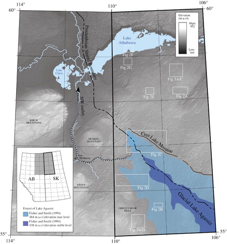
Figure 1. Location map showing northeast Alberta and northwest Saskatchewan. Major locations of physiographic features, including the northwest outlet of Lake Agassiz, the Precambrian Shield boundary, the Cree Lake Moraine and the extent of glacial Lake Agassiz are labelled. The bordering area within Alberta has been previously mapped by Atkinson, Utting, and Pawley (Citation2014a). Area of mapping corresponding to this study is outlined in bold. The locations of figures 2A-G and 3A-D are marked by white rectangles.
2. Methods
2.1. Primary data
The glacial geomorphology of northwest Saskatchewan was primarily mapped from hillshade imagery derived from 1-arc Shuttle Radar Topography Mission (SRTM) digital elevation models. These data were selected as they provide the best to-date available spatial coverage and resolution (∼30 m pixel size) for the study area. Data were downloaded in GeoTIFF format from GeoGratis (http://geogratis.cgdi.gc.ca) and then projected in Universal Transverse Mercator (UTM) zone 12N referenced to the North American Datum 1983.
As proposed by CitationSmith and Clark (2005), to minimise azimuth bias, multiple illumination angles were used to aid mapping. Illumination angles orthogonal to each other were used to account for the varying orientation and scale of landforms occurring in the study area (CitationSmith & Clark, 2005).
2.2. Secondary data
Multiple additional data sources assisted the identification of landforms in the study area; surficial geology maps and structural geology data (CitationSlimmon, 2011) helped to ensure glacial landforms were not interpreted where there was an alternative origin, either geological, structural or due to modern-day landscape alteration. Published literature was also used to support landform identification and provide a useful component for mapping (CitationCampbell, 1988, Citation2006, Citation2007; CitationCampbell et al., 2006; CitationHanson, 2014, Citation2015a, Citationb, Citationc; CitationSchreiner, 1984a, Citationb, Citationc, Citationd, Citatione, Citationf, Citationg, Citationh, Citationi, Citationj; CitationScott, 1965; CitationShaw et al., 2010; CitationSimpson, 1988, Citation1997; CitationSlimmon, 2011). However, as previously published maps portray varying landform types and occur at varying map scales depending on the region and purpose of the mapping, all previously mapped areas were remapped.
2.3. Landform mapping
A repeat-pass method (i.e. landform by landform and area by area type) was employed to ensure consistency in the final map. Each landform type was mapped for the entire study area ensuring multiple passes of all areas, thus allowing for details to be added or refinements made to the initial mapping with each pass. Mapping was conducted at 1:30,000–1:70,000. A variable scale was used depending on the landform type under investigation. Individual landforms were identified on the imagery based on their morphology, spatial arrangement and association with other features (see for diagnostic characteristics). To enable detailed inspection of landforms and their associated patterns and systems, this map is designed to be printed and viewed at AO size (841×1189 mm). Each individual landform was identified and digitised as a single line or a closed polygon depending on its shape and size in relation to SRTM data resolution. Ten landform types were mapped: ice flow parallel lineations (flutings, drumlins, mega-scale glacial lineations, and crag-and-tail ridges), moraines (major and minor), ice-thrust ridges, crevasse-fill ridges, meltwater landforms (major and minor meltwater channels and eskers), palaeo-shorelines, and dunes (). These landform types are now discussed below.
Figure 2. SRTM-derived hillshade imagery and geomorphological mapping of landforms. (A) SRTM imagery of drumlins north of the Cree Lake Moraine. (B) SRTM imagery of a collection of ice-thrust ridges associated with a small water-filled depression (ice-thrust ridges outlined with dashed white line). (C) SRTM imagery and geomorphological mapping of the Cree Lake Moraine (major moraine ridges outlined as brown polygons, eskers indicated with red lines and lineations with black lines). (D) SRTM imagery of a major meltwater channel flowing east-west into Alberta. (E) SRTM imagery of an esker ridge and network (ridge crest indicated by white arrows). (F) SRTM imagery of palaeo-shorelines surrounding Lake Athabasca (most prominent palaeo-shorelines indicated by white arrows). (G) SRTM imagery of parabolic dunes (dune crest indicated by white arrows).
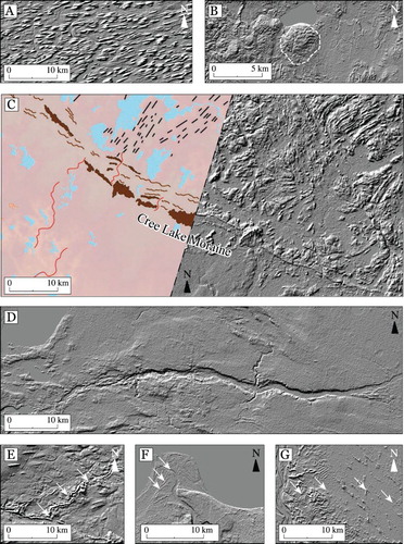
Table 1. Diagnostic criteria that underpin the identification of geomorphological features from SRTM imagery.
3. Results: descriptions of glacial geomorphology
3.1. Ice flow parallel lineations
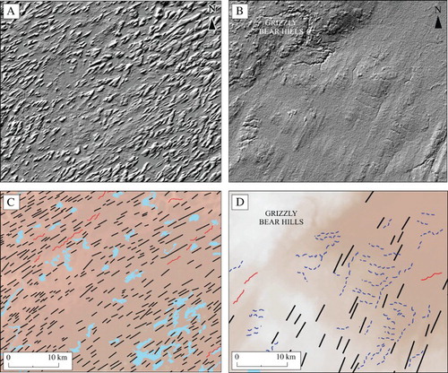
Ice flow parallel lineations include flutings, drumlins, mega-scale glacial lineations, and crag-and-tail ridges ((a)). Lineations mapped here confirm and extend the previously mapped inventory; this is especially evident north of the Cree Lake Moraine where the number of lineations is considerably denser than portrayed by previous mapping. Lineations show a complex pattern across the study area and occur extensively except in areas where bedrock is exposed (e.g. in NTS 74O and 74N, north of Lake Athabasca). A clear division in the morphology of lineations is recorded within the mapped area (). In the northern part of the study area, which overlies the Canadian Shield, lineations are of high density and comprise varied northeast–southwest orientations. These lineations are typically 100–250 m wide and 800–1500 m long, with elongation ratios between 5:1 and 8:1 ((a,c)). In contrast, south of the Canadian Shield boundary, glacial lineations display higher attenuation, with elongation ratios ranging between 15:1 and 86:1 ((b,d)). Their orientations are more complex, documenting substantial changes in ice flow directions.
Figure 3. SRTM imagery displaying lineations from either side of the Shield boundary. (A) Densely spaced drumlins displaying low length to width ratios north of the Cree Lake Moraine. (B) Highly attenuated fluting orientated NE–SW east of the Grizzly Bear Hills. (C)/(D) Areas of corresponding geomorphological mapping, lineations indicated with black lines, eskers with red lines and meltwater channels with dashed blue lines. See for location of panels.
3.2. Moraines (major and minor)
Moraines occur as arcuate ridges that collectively display lobate planforms. These landforms are split into two categories based on size. Minor moraines are typically 1–10 m high, 50–100 m wide, and up to 5 km long, and are mapped as single lines drawn along the crest of the ridge. Major moraine ridges range between 1 and 3 km wide, up to 60 km long and 50 m high, and exhibit obvious outlines; these were mapped as polygons ((c)).
The Cree Lake Moraine approximately parallels the lithological transition to the Canadian Shield (). This moraine system is broadly arcuate and extends from northwest Alberta across the majority of the mapping area. Several prominent moraine ridges also occur northwest of the Cree Lake Moraine and are associated with a narrow topographic low north of Cree Lake. Additionally, linear moraine ridges, occur at the northwestern edge of the Grizzly Bear Hills, and mark the margin of a smoothed corridor of lineated ground. The morphology and position of these moraines in relation to lineated ground are consistent with lateral shear moraines and are thus interpreted as marking the former margin of a zone of fast ice flow from the surrounding ice sheet (CitationDyke & Morris, 1988; CitationHodgson, 1994; CitationStokes & Clark, 2002).
3.3. Ice-thrust ridges
Ice-thrust ridges are large, parallel, and generally arcuate and sharply crested landforms. Ridges range from 10–60-m high and 150–800-m long and are visible throughout the mapped area, occurring in small concentrations. In many cases these ridges are accompanied by a depression (typically water-filled) directly behind the ridge arc, commonly known as a hill-hole pair ((b)). Ice-thrust ridges have previously been mapped sparsely within the study area; therefore, our mapping extends the known distribution and demonstrates that these features are considerably more widespread than previously thought.
3.4. Crevasse-fill ridges
Crevasse-fill ridges occur in small concentrations as linear, curvilinear or v-shaped ridges. These ridges range from 1–5-m high and 200–1200-m long, and are oriented parallel or perpendicular to ice flow. Relatively few crevasse-fill ridges have been previously mapped within the study area and we demonstrate that these features are more prevalent than prior studies suggest. We acknowledge that small crevasse-fill ridges might have been missed in our mapping because their size does not allow for their recognition at the mapping scale.
3.5. Meltwater channels (major and minor)
A complex and extensive system of abandoned channels occur throughout the mapped area and show evidence that drainage has been influenced by regional ice retreat patterns ((d)). These channels have been primarily carved by proglacial, supraglacial or subglacial meltwater streams and display incised meanders interspersed with straight reaches. Major channel networks (>30-km long), that are deeply incised and well-defined have been mapped as solid lines, smaller and more subdued forms are mapped as dashed lines. Due to the small scale of many channels, some of the mapped channel features may be perennial or intermittent subaerial streams, but it is difficult to conclusively differentiate between these using the imagery available.
3.6. Eskers
Single ridge eskers and esker networks composed of large sinuous eskers, which join to multiple smaller esker ridges, are prominent throughout the mapped area ((e)). These range in height between 5 and 10 m and in length between 2 and 10 km. We acknowledge that small eskers might have been missed in our mapping because their size does not allow for their recognition at the mapping scale.
3.7. Palaeo-shorelines
Palaeo-shorelines are erosional or depositional features. These landforms are most prominent in areas to the immediate south of Lake Athabasca ((f)). Faint remnants of shorelines are also recorded on the northeastern edge of the Grizzly Bear Hills.
3.8. Dunes
Parabolic and longitudinal dunes occur throughout the study area, but most commonly on the low topography surrounding Lake Athabasca ((g)). While these landforms are not glacial, they are included in our mapping as they started to form shortly after deglaciation and can be considered in a broader sense as a part of the glacial modification of the landscape. We acknowledge that small or faint dunes have been missed in our mapping because their size does not allow for their recognition at the 30 m SRTM DEM mapping scale.
4. Implications and conclusions
The accompanying map provides a comprehensive representation of the glacial landform record in northwest Saskatchewan. This mapped landform assemblage documents a complex glacial history in the region, with traces of multiple ice flow directions overprinted by the landforms of the deglacial envelope. Flow patterns and dynamics revealed by our landform mapping replicate much that has been reported in the existing literature; however in many places it has added significant additional complexities to the landform record. The existence of cross cutting relationships between different landform packages has significant implications for the spatial and temporal configuration and evolution of fast ice flow in the region, and provides the prerequisite for future reconstructions of the deglacial dynamics and chronology of northwest Saskatchewan.
Software
Hillshade models from SRTM DEM data were produced using Esri ArcMap 10.1. On-screen digitising of landform crestline, break-in-slope and change in direction were conducted in ArcMap 10.1. The map was then exported and finalised using Adobe Illustrator 10.0.
Data
ESRI shapefiles used in the accompanying map are supplied for all glacial and postglacial landform types discussed.
TJOM_1342212(Raw Data).zip
Download Zip (8.3 MB)Glacial Landforms of Northwest Saskatchewan.pdf
Download PDF (27 MB)Acknowledgements
We thank reviewers Nigel Atkinson, Heike Apps and Carolyn Eyles for their helpful comments. We also thank Associate Editor Chris Clark.
Disclosure statement
No potential conflict of interest was reported by the authors.
Additional information
Funding
Related Research Data
References
- Atkinson, N., Utting, D. J., & Pawley, S. P. (2014a). Glacial landforms of Alberta. Alberta Geological Survey, AER/AGS, Map 604.
- Atkinson, N., Utting, D. J., & Pawley, S. P. (2014b). Landform signature of the Laurentide and Cordilleran ice sheet across Alberta during the last glaciation. Canadian Journal of Earth Sciences, 51, 1067–1083. doi: 10.1139/cjes-2014-0112
- Breckenridge, A. (2015). The Tintah-Campbell gap and implications for glacial Lake Agassiz drainage during the Younger Dryas cold interval. Quaternary Science Reviews, 117, 124–134. doi: 10.1016/j.quascirev.2015.04.009
- Broecker, W. S., Kennett, J., Flower, B., Teller, J., Trumbore, S., Bonani, G., & Wolfi, W. (1989). Routing of meltwater from the Laurentide Ice Sheet during the Younger Dryas cold episode. Nature, 341, 318–321. doi: 10.1038/341318a0
- Campbell, J. E. (1988). Surficial Geology of the Buffalo Narrows Area (73N) Saskatchewan. Saskatchewan Research Council, Sedimentary Resources, Map 1:250,000 scale.
- Campbell, J. E. (2006). Fond-du-Lac Project: Surficial Geology of the Western Fond-du-Lac Area, South-Central Beaverlodge Domain (Part of NTS 74O/5 and 6). 1:50,000 scale preliminary map with Summary of Investigations 2006, Volume 2, Saskatchewan Geological Survey, Saskatchewan Industry and Resources (Miscellaneous Report 2006-4.2).
- Campbell, J. E. (2007). Quaternary investigations in the Fond-du-Lac Area (part of NTS 74O/6 and /7), Southeast Beaverlodge Domain (Fond-du-Lac Project). 1:50,000 scale preliminary map with Summary of Investigations 2007, Volume 2, Saskatchewan Geological Survey, Saskatchewan Industry and Resources (Miscellaneous Report 2007-4.2).
- Campbell, J. E., Ashton, K. E., & Knox, B. (2006). Fond-du-Lac Project: Ice Flow Indicators, Western Fond-du-Lac Area, South Central Beaverlodge Domain (Part of NTS 74O/5 and 6). 1:50,000 scale preliminary map with Summary of Investigations 2006, Volume 2, Saskatchewan Geological Survey, Saskatchewan Industry and Resources (Miscellaneous Report 2006-4.2).
- Christiansen, E. A. (1979). The Wisconsinan deglaciation, of southern Saskatchewan and adjacent areas. Canadian Journal of Earth Sciences, 16, 913–938. doi: 10.1139/e79-079
- Clark, P. U., Marshall, S. J., Clarke, G. K. C., Hostetler, S. W., Licciardi, J. M., & Teller, J. T. (2001). Freshwater forcing of abrupt climate change during the last glaciation. Science, 293, 283–287. doi: 10.1126/science.1062517
- Dyke, A. S., Moore, A., & Robertson, L. (2003). Deglaciation of North America. Geological Survey of Canada, Open File 1574. doi: 10.4095/214399
- Dyke, A. S., & Morris, T. F. (1988). Drumlin fields, dispersal trains, and ice streams in Arctic Canada. Canadian Geographer, 32, 86–90. doi: 10.1111/j.1541-0064.1988.tb00860.x
- Evans, D. J. A., Clark, C. D., & Rea, B. R. (2008). Landform and sediment imprints of fast glacier flow in the southwest Laurentide Ice Sheet. Journal of Quaternary Science, 23, 249–272. doi: 10.1002/jqs.1141
- Evans, D. J. A., Young, N. J. P., & Ó Cofaigh, C. (2014). Glacial geomorphology of terrestrial-terminating fast flow lobes/ice stream margins in the southwest Laurentide Ice Sheet. Geomorphology, 204, 86–113. doi: 10.1016/j.geomorph.2013.07.031
- Fisher, T. G., & Smith, D. G. (1994). Glacial Lake Agassiz: Its northwest maximum extent and outlet in Saskatchewan (Emerson phase). Quaternary Science Reviews, 13, 845–858. doi: 10.1016/0277-3791(94)90005-1
- Fisher, T. G., Waterson, N., Lowell, T. V., & Hajdas, I. (2009). Deglaciation ages and meltwater routing in the Fort McMurray region, northeastern Alberta and northwestern Saskatchewan, Canada. Quaternary Science Reviews, 28, 1608–1624. doi: 10.1016/j.quascirev.2009.02.003
- Hanson, M. A. (2014). Ice-flow indicator map, Pine Channel and Fond du Lac River area (parts of NTS 74O01, 02, 07 and 08). 1:50,000 scale preliminary map with Summary of Investigations 2014, Volume 2, Saskatchewan Geological Survey, Saskatchewan Ministry of the Economy (Miscellaneous Report 2014-4.2).
- Hanson, M. A. (2015a). Ice-flow indicator map, Pine Channel and Fond du Lac River areas (parts of NTS 74O01, 02, 07, and 08, and 74P05, and 06). 1:50,000 scale preliminary map with Summary of Investigations 2015, Volume 2, Saskatchewan Geological Survey, Saskatchewan Ministry of the Economy (Miscellaneous Report 2015-4.2).
- Hanson, M. A. (2015b). Preliminary ice-flow indicator mapping, Fond du Lac River area, southern Tantato Domain and northern Athabasca Basin, Saskatchewan. 1:50,000 scale preliminary map with Summary of Investigations 2015, Volume 2, Saskatchewan Geological Survey, Saskatchewan Ministry of the Economy, (Miscellaneous Report 2015-4.2).
- Hanson, M. A. (2015c). Surficial Geology of the West Fond du Lac River area (parts of NTS 74O01, 02, 07 and 08). 1:50,000 scale preliminary map with Summary of Investigations 2015, Volume 2, Saskatchewan Geological Survey, Saskatchewan Ministry of the Economy (Miscellaneous Report 2015-4.3).
- Hodgson, D. A. (1994). Episodic ice streams and ice shelves during retreat of the northwestern most sector of the Late Weichselian Laurentide Ice Sheet over the central Canadian Arctic Archipelago. Boreas, 23, 14–28. doi: 10.1111/j.1502-3885.1994.tb00582.x
- Kleman, J., Jansson, K., De Angelis, H., Stroeven, A. P., Hättestrand, C., Alm, G., & Glasser, N. F. (2010). North American ice sheet build-up during the last glacial cycle, 115–21 kyr. Quaternary Science Reviews, 29, 2036–2051. doi: 10.1016/j.quascirev.2010.04.021
- Margold, M., Stokes, C. R., & Clark, C. D. (2015a). Ice streams in the Laurentide Ice Sheet: Identification, characteristics and comparison to modern ice sheets. Earth-Science Reviews, 143, 117–146. doi: 10.1016/j.earscirev.2015.01.011
- Margold, M., Stokes, C. R., & Kleman, J. (2015b). Ice streams in the Laurentide Ice Sheet: A new mapping inventory. Journal of Maps, 11, 380–395. doi: 10.1080/17445647.2014.912036
- Moran, S. R., Clayton, L., Hooke, R. L., Fenton, M. M., & Andriashek, L. D. (1980). Glacier-bed landforms of the prairie region of North America. Journal of Glaciology, 25, 457–476. doi: 10.1017/S0022143000015306
- Ó Cofaigh, C., Evans, D. J. A., & Smith, R. (2010). Large-scale reorganization and sedimentation of terrestrial ice streams during late Wisconsinan Laurentide Ice Sheet deglaciation. Geological Society of America Bulletin, 122, 743–756. doi: 10.1130/B26476.1
- Prest, V. K., Grant, D. R., & Rampton, V. N. (1968). Glacial map of Canada. Geological Survey of Canada, Map 1253A.
- Ross, M., Campbell, J. E., Parent, M., & Adams, R. S. (2009). Palaeo-ice streams and the subglacial landscape mosaic of the North American mid-continental prairies. Boreas, 38, 421–439. doi: 10.1111/j.1502-3885.2009.00082.x
- Schreiner, B. I. (1984a). Quaternary geology of the Precambrian Shield, Saskatchewan (Saskatchewan Energy and Mines, Report 221).
- Schreiner, B. I. (1984b). Quaternary geology of the Ile-a-la-Crosse area (NTS 73O). Saskatchewan Energy and Mines (Open File Rep. 84-5).
- Schreiner, B. I. (1984c). Quaternary geology of the Mudjatik area (NTS 74B). Saskatchewan Energy and Mines (Open File Rep. 84-8).
- Schreiner, B. I. (1984d). Quaternary geology of the La Loche area (NTS 74C). Saskatchewan Energy and Mines (Open File Rep. 84-9).
- Schreiner, B. I. (1984e). Quaternary geology of the Cree Lake area (NTS 74G). Saskatchewan Energy and Mines (Open File Rep. 84-12).
- Schreiner, B. I. (1984f). Quaternary geology of the Lloyd Lake area (NTS 74F). Saskatchewan Energy and Mines (Open File Rep. 84-13).
- Schreiner, B. I. (1984g). Quaternary geology of the Livingstone Lake area (NTS 74J). Saskatchewan Energy and Mines (Open File Rep. 84-16).
- Schreiner, B. I. (1984h). Quaternary geology of the William River area (NTS 74 K). Saskatchewan Energy and Mines (Open File Rep. 84-17).
- Schreiner, B. I. (1984i). Quaternary geology of the Fond-du-Lac area (NTS 74O). Saskatchewan Energy and Mines (Open File Rep. 84-20).
- Schreiner, B. I. (1984j). Quaternary geology of the Tazin Lake area (NTS 74N). Saskatchewan Energy and Mines (Open File Rep. 84-21).
- Scott, B. P. (1965). Geology of the Upper Clearwater Area. Saskatchewan Energy and Mines (Open File Report 85-2).
- Shaw, J., Sharpe, D., & Harris, J. (2010). A flowline map of glaciated Canada based on remote sensing data. Canadian Journal of Earth Sciences, 47, 89–101. doi: 10.1139/E09-068
- Simpson, M. A. (1988). Surficial geology of the Ile-a-la-Crosse Area (73O) Saskatchewan. Saskatchewan Research Council, Sedimentary Resources, Map 1:250,000 scale.
- Simpson, M. A. (complier). (1997). Surficial geology map of Saskatchewan. Saskatchewan Energy and Mines/ Saskatchewan Research Council. Map 1:1000,000 scale.
- Slimmon, W. L. (2011). Geological Atlas of Saskatchewan; Saskatchewan. Ministry of Energy and Resources (Miscellaneous Report, 2011–7 CD_ROM, version 14). Retrieved from http://www.infomaps.gov.sk.ca/website/SIR_Geological_Atlas/SK
- Smith, M. J., & Clark, C. D. (2005). Methods for the visualization of digital elevation models for landform mapping. Earth Surface Processes and Landforms, 30, 885–900. doi: 10.1002/esp.1210
- Stokes, C. R., & Clark, C. D. (2002). Ice stream shear margin moraines’. Earth Surface Processes and Landforms, 27, 547–558. doi: 10.1002/esp.326
- Stokes, C. R., Margold, M., Clark, C. D., & Tarasov, L. (2016). Ice stream activity scaled to ice sheet volume during Laurentide Ice Sheet deglaciation. Nature, 530, 322–326. doi: 10.1038/nature16947
- Teller, J. T., & Clayton, L. (Eds). (1983). Glacial Lake Agassiz. Geological Association of Canada, Special Paper 26, 117–131.
- Teller, J. T., & Leverington, D. W. (2004). Glacial Lake Agassiz: A 5000 yr history of change and its relationship to the d18O record of Greenland. Geological Society of America Bulletin, 116, 729–742. doi: 10.1130/B25316.1