
ABSTRACT
The Paleozoic rocks underlying the western third of the New Haven Quadrangle, Connecticut, are mapped at a scale of 1:24,000. This area of ∼41.5 km2, previously mapped only in reconnaissance, contains polymetamorphic argillites and mafic rocks. The northern portion of the mapped area contains the pelitic Wepawaug schist, whereas the southern portion is underlain by the pelitic Savin Schist. Between them lies the Maltby Lakes Complex (MLC) that contains newly identified fault slivers of variably metamorphosed mafic phyllites and amphibolites. Metamorphic foliations in both the MLC and the Savin Schist are truncated by a swarm of basalt dikes: the Allingtown porphyry, which is itself commonly schistose and locally mylonitic. Previous interpretations held that these rocks constitute a conformable, northwest-topping stratigraphic sequence. In contrast, we propose that Ordovician(?) oceanic rocks of the MLC were variably metamorphosed and faulted against the Ordovician(?) Savin Schist. These were intruded by a swarm of stitching Allingtown dikes. This package of rocks was then faulted against Siluro-Devonian(?) Wepawaug forearc sediments. Existing thermochronology indicates a Devonian age of the subsequent regional metamorphism, overprinted by low-grade Permian fabrics associated with dextral transpression and final terrane assembly.
1. Introduction
1.1. Geologic setting
The Orange-Milford Belt (OMB) of mafic and argillitic rocks lies at the southeastern margin of Connecticut’s Western Highlands (CitationRodgers, 1985). It is bound on the west by the East Derby Shear Zone (EDSZ), a greenschist facies ductile fault (CitationHatch & Stanley, 1973; Wathen et al., Citation2015). West of this fault are high-grade metasediments and orthogneisses associated with the Laurentian margin (CitationCrowley, 1968; CitationSevigny & Hanson, 1993, Citation1995). The eastern boundary of the OMB is marked by the nonconformably overlying arkoses of the Hartford basin. Just south of the New Haven quadrangle the Eastern Border Fault of the Hartford basin places anatectic rocks of peri-Gondwanan affinity (CitationAleinikoff et al., 2007) against the OMB. The tectonic affinities of the rocks of the OMB are presently unknown. Along-strike structural relationships suggest the OMB may correlate with the Connecticut Valley Trough (CVT) in Vermont. In the absence of independent constraints, some units in New Haven quadrangle are given tentative age assignments based on this correlation, as discussed below (Ages of Map Units).
The OMB was regionally metamorphosed during Devonian Acadian orogenesis (CitationGrowdon, Kunk, Wintsch, & Walsh, 2013). Fabrics formed during this event are now exposed in a field gradient that increases in metamorphic intensity from east to west (CitationAgue, 1994a, Citation1994b; CitationFritts, 1965a, Citation1965b). The relatively low grade of regional metamorphism in eastern exposures allowed the rocks there to escape the thorough Devonian overprinting that visited the western OMB. Our new mapping of the eastern OMB in New Haven quadrangle (Main Map) reveals slivers of high-grade mafic rocks enclosed within chlorite grade fabrics. These tectonic slivers preserve evidence of early Paleozoic metamorphism otherwise undocumented in south-central Connecticut.
1.2. Previous work
Previous work in the New Haven quadrangle has involved only reconnaissance mapping. CitationPercival (1842) described a ‘Chloritic formation’ at the southeastern extent of the Western Highlands. This ‘formation’ included what we presently identify as the Savin Schist, Allingtown porphyry, and Maltby Lakes Complex (MLC). The first geochemical analyses (CitationDana, 1876; CitationHawes, 1876) identified the Maltby Lakes greenstones and the Allingtown porphyry as having basaltic compositions. More recent analyses reveal nominally mid-ocean ridge basalt (MORB) like trace element abundances in the MLC (CitationDeasy & Wintsch, 2015; CitationDeasy et al., 2015; CitationJones, Wintsch, & Growdon, 2009). Quadrangle-scale mapping of most of the OMB was performed by Crawford E. Fritts in the Mount Carmel (Citation1963a), Ansonia (Citation1965a), and Milford (Citation1965b) quadrangles. He interpreted the metamorphic foliations in the area as inherited from primary sedimentary or volcaniclastic bedding. On the basis of the apparent contiguity of these fabrics, CitationFritts (1965a, Citation1965b) concluded that the Savin Schist (‘Derby Hill Formation’ in his study), the Maltby Lakes ‘volcanics,’ and the Wepawaug ‘Formation’ constituted a conformable stratigraphic sequence topping to the northwest. Furthermore, he recognized the intrusive nature of the Allingtown porphyry from the low-angle truncations of earlier fabrics in the Savin Schist, and he considered the geometry of the unit to be sill-like. Fritts mistook the EDSZ, which is marked by chlorite-muscovite phyllites and phyllonites, as correlative with the Savin Schist. On these bases he interpreted the entire OMB to have been folded into an upright, north-plunging syncline.
The most detailed previous study of the OMB in the New Haven quadrangle is mapping by CitationBurger (1967), which recognizes Fritts’ false correlation of the chlorite phyllites bounding the OMB east and west, and proposes the name Savin Schist – after Savin Rock, on the shore of Long Island Sound – for the eastern unit. This name is retained in the current study.
The eastern boundary of the newly mapped area is marked by the Triassic New Haven Arkose which nonconformably overlies the Paleozoic rocks. Previous studies have addressed the stratigraphy and petrology of the sandstones (CitationHubert, Feshbach-Meriney, & Smith, 1992; Krynine Citation1950; CitationMerino, Girard, May, & Ranganathan, 1997). Dating of detrital muscovite by 40Ar/39Ar methods has shown the grains to have dominantly Permian cooling ages, necessitating an eastern provenance for the sediments and net westward dip of the nonconformable surface at the time of deposition (CitationBlevins-Walker, Kunk, & Wintsch, 2001).
CitationArmstrong, Barton, Carmalt, and Crowley (1970) report an Rb-Sr whole-rock isochron apparent age of ∼460 Ma for the MLC. This is interpreted here as the time of Rb-Sr exchange during high-grade fabric development, and may be related to Taconic orogenesis. Monazite grains in the high-grade Wepawaug Schist dated by U/Pb methods record early to mid-Devonian growth (CitationLanzirotti & Hanson, 1996). Thermochronologic investigation of the OMB in the Ansonia quadrangle by 40Ar/39Ar methods reveals muscovites with Devonian cooling ages preserved in microlithons between overprinting folia of muscovites with Permian crystallization ages (CitationGrowdon et al., 2013), ages that are consistent with deformation broadly attributable to the Acadian and Alleghanian orogenies, respectively. Fabrics conformable with these are identified in the New Haven quadrangle, as discussed below.
2. Methods
2.1. Map area
The map area includes approximately the western third of New Haven quadrangle in south-central Connecticut (EPSG 2234). The eastern boundary of the study area, defined as the Triassic nonconformity, is geologically, not geographically, controlled and is therefore somewhat irregular. Coordinates for the map area clockwise from the northwest corner of the New Haven quadrangle are as follows:
2.2. Field methods
Outcrops were located using a Samsung SCH-I400 cellular phone operating the GPS Essentials freeware application. Locations were recorded in geographical coordinates using the 1983 North American datum. Of several devices employed, including two dedicated Garmin units, the Samsung provided the most accurate and precise global positioning system (GPS) coordinates (generally within 9 m), likely because the urban/suburban terrain and gentle topography allowed the Samsung device to use both satellite and Verizon Mobile networks in obtaining its position. In rare circumstances when GPS was not available, location was obtained by pace-and-compass and notated on the field sheet.
Structures were measured with a standard azimuthal Brunton compass. All field data were recorded in pencil in field notebooks. Contacts and lithologies were recorded on 1:3000, 1:6000, or 1:12,000 field sheets, depending on outcrop density and local structural complexity. Analytical data acquired by a variety of methods, including X-ray fluorescence, X-ray diffraction, and electron probe microanalysis, have contributed to the characterization and discrimination of the map units presented here (CitationDeasy, Bish, & Wintsch, 2016; CitationDeasy & Wintsch, 2015; CitationDeasy, Wintsch, & Jones, 2014; CitationDeasy et al., 2015).
2.3. Map compilation
Basemap data (topography, transportation, hydrography, and geographic names) were downloaded as .zip files from www.ct.gov/deep/gisdata and were processed in Esri ArcGIS 10.1. Field data were compiled in Microsoft Excel and uploaded to ArcGIS 10.1 for representation. Map symbols follow the Federal Geographic Data Committee Cartographic Standard for Geologic Map Symbolization (CitationFGDC, 2006). The map was prepared with the Connecticut State Plane FIPS (US Feet) projection. Many representation layers were exported from ArcGIS as .ai files, and the final map was assembled in Adobe Illustrator CS6. Stereonets in were prepared with Stereonet for Windows (CitationAllmendinger, 2004). Stereonets in were prepared using WindRose for Matlab (CitationPereira, 2015). Color photographs (–) were taken with a Nikon D80 digital camera and annotated in Adobe Illustrator CS6.
Figure 1. Orientations of metamorphic fabrics and structures. The map is subdivided into four ductile domains. Domain A contains rocks of the Wepawaug Schist. Domain B contains rocks of the Maltby Lakes Complex (MLC) south of the Silver Brook Fault (SBF) and west of the Western Border Fault (WBF) whose fabrics are dominated by chlorite. Domain C contains rocks of the MLC east of the WBF and north of the Indian River Fault (not shown). The fabrics of the metamafic rocks here are defined dominantly by amphibole. Domain D contains the main bodies of the Allingtown dike swaarm and the Savin Schist. Stereonets prepared with Allmendinger’s Stereonet for Windows (CitationAllmendinger, 2004). Best fit great circles and mean vectors calculated assuming cylindrical Bingham axial distribution. Orientations of metamorphic fabrics and structures. The map is subdivided into four ductile domains. Domain A contains rocks of the Wepawaug Schist. Domain B contains rocks of the Maltby Lakes Complex (MLC) south of the Silver Brook Fault (SBF) and west of the Western Border Fault (WBF) whose fabrics are dominated by chlorite. Domain C contains rocks of the MLC east of the WBF and north of the Indian River Fault (not shown). The fabrics of the metamafic rocks here are defined dominantly by amphibole. Domain D contains the main bodies of the Allingtown dike swaarm and the Savin Schist. Stereonets prepared with Allmendinger’s Stereonet for Windows (CitationAllmendinger, 2004). Best fit great circles and mean vectors calculated assuming cylindrical Bingham axial distribution.
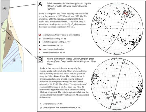
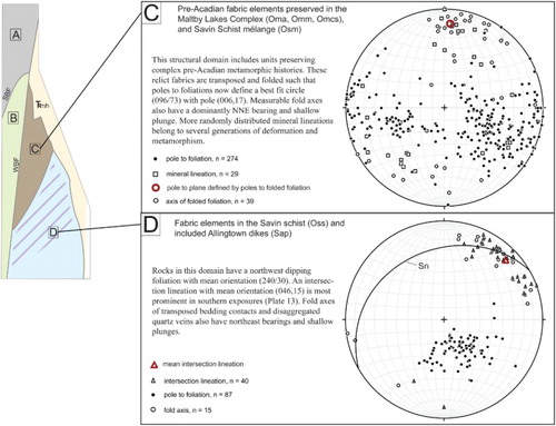
Figure 2. Orientations of brittle structures. The map area is subdivided into six brittle domains A–F. Some of the structural domain boundaries are themselves faults: The Silver Brook Fault (SBF), Bishop’s Pond Fault (BPF), and the Western Border Fault (WBF). Structural domain boundaries not labeled as faults are lithologic contacts. Windrose diagrams showing the orientations of through-going joints in each structural domain were generated with WindRose for Matlab (CitationPereira, 2015).
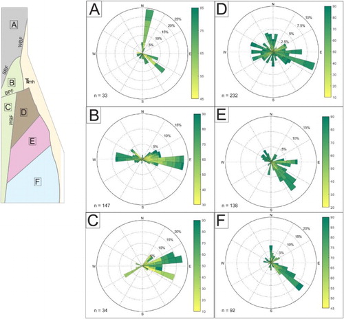
Plate 1. Triassic nonconformity. Where this surface is exposed in New Haven quadrangle, the basal conglomerate (nh) overlies epidote-pod, chlorite schist (Omc). In this northwest-facing image, the nonconformable surface (dashed line) has an eastward dip (hammer for scale). The inset stereonet shows poles to the nonconformable surface (yellow circles, n = 23). The surface, though irregular, has a mean orientation of ∼010/35 (dashed line). The exposure of this nonconformity has the same orientation as the contemporaneous surface exposed in Roaring Brook (gray circles, n = 4).
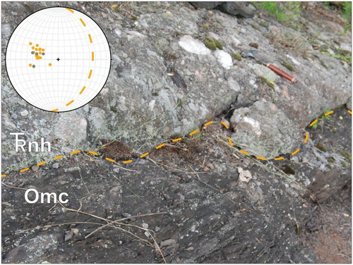
Plate 2. Multiple fabrics in the Wepawaug phyllite (SDws). In this north-facing photograph psammitic bedding (So) isasymmetrically folded. The axial planes (AP, dashed lines) of these folds are subparallel to the dominant muscovite-chlorite cleavage in adjacent phyllitic layers (Sn). The orientation of cleavage refraction between psammitic and phyllitic layers suggest dextral shear during fabric formation (arrows). In the right-hand side of the image, this fabric is sharply truncated by another muscovite-chlorite fabric (Sn + 1) that contains weakly boudinaged quartz veins.
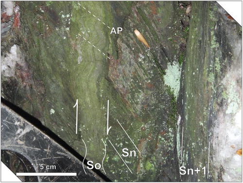
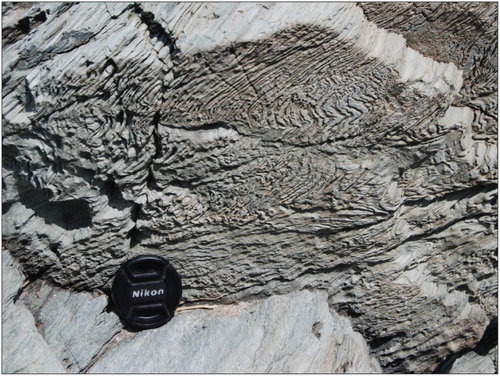
Plate 3. Deformed Wepawaug phyllite (SDws) near Silver Brook Fault. In this north-facing image quartz veins are variably folded and attenuated into the mylonitic Sn + 1 muscovite-chlorite fabric (see ). in the footwall of the Silver Brook Fault. Lens cap is 53 mm in diameter.
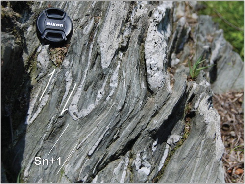
Plate 4. Allingtown dike (Sap) cutting Maltby Lakes Complex mylonite (Omm). The epidote-amphibole fabric in the mylonite (Omm) is truncated (dashed line) by a deformed porphyritic dike (Sap). Later deformation has transposed the contact, crenulated the mylonite, and given the porphyry a weak foliation, roughly parallel to the axial plane of folds in the mylonite. Field of view is approximately 20 cm.
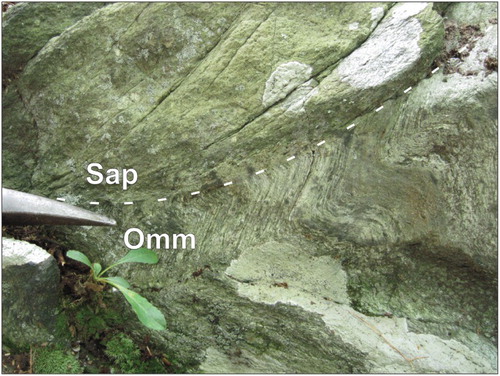
Plate 5. Sheeted dikes of the Allingtown dike swarm (Sap). One of many intrusive contacts (dashed line) exposed within the main body of the Allingtown dike swarm (Sap). Inset stereogram shows poles to undeformed contacts of newer Sap dikes intruding older Sap dikes. Half dikes and dikes with two chill margins are both exposed. Half dikes do not show systematic opening direction. Contacts with eastward-coarsening porphyry (hollow circles, n = 10) are slightly more abundant than westward-coarsening contacts (filled circles, n = 8).
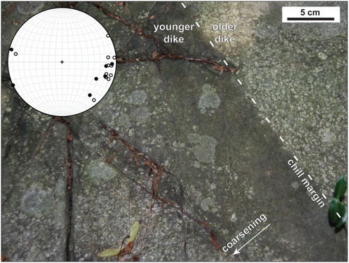
Plate 6. Allingtown dike (Sap) cutting the Savin Schist (Oss). The weakly foliated dike truncates (dashed line) a coarse-grained muscovite-chlorite-quartz metamorphic fabric in the schist (Sn-1, dotted line). Later deformation has folded and refoliated the schist (Sn, solid lines) and penetratively chloritized the dike.
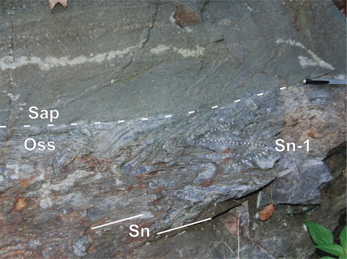
Plate 7. Epidote-pod chlorite schist and mylonite (Omc). Fine-grained aggregates of epidote (Ep) form boudins in a fine-grained chlorite fabric. Low-weathering extensional fractures (dashed lines) in epidote pods are filled with carbonate or, uncommonly, asbestiform amphibole. The epidote pods are thought to have originated as veins, disaggregated by shearing. Also present in this image are coarse-grained, subspherical epidote porphyroblast aggregates (arrows).
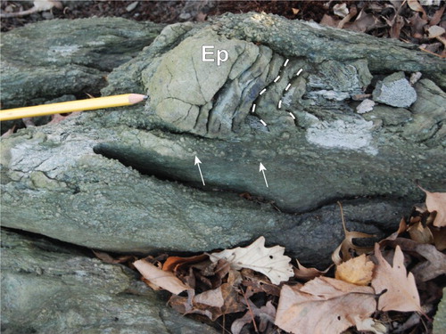
Plate 8. Metagabbroic inclusions (Omg) in chlorite mylonite (Omc). The chlorite schist (Omc) includes 0.01–5 m inclusions of a massive, coarse-grained metaggabro (Omg) containing saussuritied plagioclase and uralitized clinopyroxene. Lens cap is 53 mm in diameter.
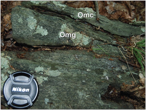
Plate 9. Epidote-amphibole gneiss (Oma) and mylonite (Omm). The Maltby Lakes Complex preserves lozenges of amphibolite facies, prograde mafic gneiss (Oma), and mylonite (Omm). The image above shows the partial replacement of the gneissic actinolite-plagioclase texture by the epidote-actinolitic hornblende mylonite.
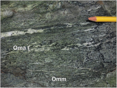
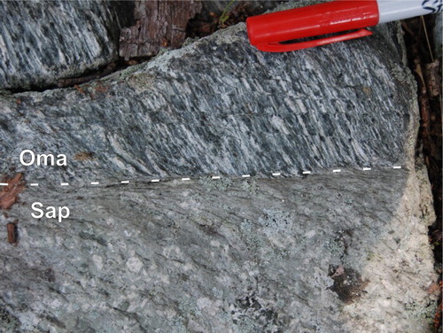
Plate 10. Allingtown dike (Sap) cutting coarse-grained fabric in mafic gneiss (Oma). In this image a massive porphyritic dike (Sap) cuts the strongly lineated gneiss (Oma) at a high angle (dashed line). This locality was apparently untouched by later deformation that elsewhere folded units of the Maltby Lakes Complex and foliated the Allingtown dikes (e.g. ).
3. Results
3.1. Identification of map units
The immediate goal of mapping was the identification and discrimination of Paleozoic units. The eastern boundary of the map area was therefore set as the nonconformity between the Paleozoic units and the overlying Triassic New Haven arkose (Trnh, ). Units are distinguished by mineralogy, textures, and structures, and locally also by mineral chemistry and whole-rock chemical compositions. While outcrop scale heterogeneities cannot be differentiated at the map scale, structurally and/or mineralogically distinct rock types that occur at many outcrop localities within a more continuous unit are given separate unit designations. For example, in the MLC, weakly foliated lozenges of metagabbro (Omg) are mapped separately from the epidote-pod mylonite (Omc).
These results broadly conform with previous studies in recognizing four major lithologic groups. These are:
the Wepawaug Schist of metasediments, dominated by phyllite (SDws, and ) with minor impure carbonate (SDwm) and foliated feldspathic metawackes (SDww);
the Allingtown Porphyry [Sap (–)], a massive to mylonitic plagioclase basalt porphyry; and
the MLC of greenstones [Omc (, , ), Omt), amphibolites [Omg (), Omm (), Oma ()], and serpentinite [Omcs ()];
the two units within the Savin Schist include a foliated mélange [Osm ()] and a strongly foliated and commonly well-lineated muscovite-chlorite schist with minor quartzite [Oss ()].
Plate 11. Calcitic serpentinite (Omcs). This cut surface exposes the mélange texture of this unit, with subangular-to-round, massive-to-foliated clasts of serpentinite (S) in a foliated serpentine, calcite, and magnetite matrix. The foliation runs parallel to that of the dominant foliation in the adjacent micaceous mélange (Osm, ).
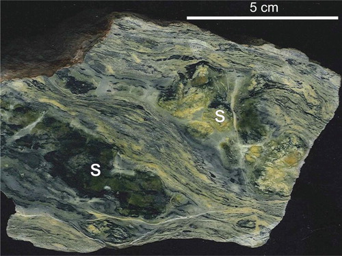
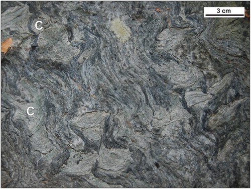
Plate 12. Savin Schist micaceous mélange (Osm). This unit is characterized by the presence of angular clasts of fine-grained chlorite schist (C) in a coarse-grained, foliated muscovite-chlorite matrix. Folded ribbons of disaggregated quartz veins are also characteristic. The dominant fabric, subvertical in this image, is truncated by intrusions of the Allingtown dike swarm.
Finally, the youngest bedrock unit is a Jurassic basalt dike (Jd) which cuts through the MLC near the Silver Brook Fault (SBF) (CitationPhilpotts & Martello, 1986).
3.2. Ages of map units
No independent constraints presently exist for the depositional age of the Wepawaug Schist. The Wepawaug Schist may correlate with the Waits River Formation of the CVT in Vermont, which was deposited in the late Silurian to early Devonian (CitationMcWilliams, Walsh, & Wintsch, 2010). The metamorphic muscovites in the Wepawaug Schist in Ansonia quadrangle have late Devonian cooling ages with Permian overprinting folia, recording deformation during the Acadian and Alleghanian orogenies, respectively (CitationGrowdon et al., 2013). The ages of the rocks of the MLC are constrained by a single whole-rock Rb-Sr age of 460 Ma (CitationArmstrong et al., 1970) that at best records the time of high-grade fabric formation. The Allingtown dike swarm correlates both structurally and geochemically with the late Silurian Comerford Intrusive Suite which intrudes the CVT (CitationDeasy & Wintsch, 2015; CitationRankin et al., 2007). No constraints on the depositional age of the Savin Schist, or on the timing of fabric development in that unit, are currently available. We therefore defer to previous workers’ assignment of this unit as Ordovician (e.g. CitationRodgers, 1985).
3.3. Metamorphism
The Paleozoic rocks mapped in New Haven quadrangle are all metamorphosed to at least lower greenschist facies conditions and most are moderately to strongly foliated and/or lineated. All members of the Wepawaug Schist are strongly foliated ((A)). Contiguous muscovite folia define the fabric of the phyllite (SDws) and impure marble (SDwm). The coexistence of K-feldspar and chlorite in the metawacke (SDww) confirms metamorphism below the biotite isograd.
The appearance of the epidote-pod chlorite schist (Omc) in the field is dominated by lenses and knots of very fine-grained epidote wrapped by contiguous folia of chlorite and minor amphibole (), suggesting deformation at upper greenschist facies conditions. The chlorite fabric envelops lozenges a few centimeters to several meters across that preserve a metagabbroic fabric of coarse-grained, poorly lineated amphibole porphyroclasts (Omg, ). The coarse-grained, well-lineated fabric of the gneissic amphibolite (Oma) persists as lozenges enveloped by amphibole mylonite (Omm, ). Both the coarse-grained fabric and the mylonitic fabric are defined by well-lineated amphibole. The coarse grains of the gneissic amphibolite (Oma) have actinolitic compositions and the fine grains in the mylonite (Omm) have hornblendic compositions, indicating deformation took place under prograde metamorphic conditions, from greenschist through amphibolite facies (CitationDeasy et al., 2015).
The relict metamorphic clasts preserved in the foliated mélange unit of the Savin Schist (Osm, ) contain fabrics defined by chlorite and white mica, suggesting lower greenschist facies crystallization. The muscovite folia that envelop the clasts were similarly developed at lower greenschist facies conditions. The coexistence of K-feldspar and chlorite in the phyllitic and psammitic rocks in the structurally lower Savin Schist (Oss) confirm metamorphism and foliation development below the biotite isograd.
3.4. Structure
3.4.1. Paleozoic metamorphic fabrics
The oldest fabrics in these rocks include the foliations in the metagabbro (Omg), in the amphibolites (Oma, Omm), and the fabrics preserved in the clasts of both mélange units (Omcs, Osm). The fabric-forming amphiboles in the mylonite (Omm) show the highest (amphibolite facies) grade of metamorphism in the map area (CitationDeasy et al., 2014), and so this fabric and that of its gneissic inclusions (Oma) must predate those of all other rocks. The 015-striking mylonitic fabric in the greenschist facies chlorite schist (Omc) suggests roughly east–west shortening and north-south extension during fabric development ((B)). Consistent with this, the fractures in brecciated epidote pods suggest north–south extension (). Poles to folded foliations in the amphibole mylonite (Omm), serpentinite (Omcs), and foliated micaceous mélange (Osm) define a plane ((C)), suggesting these units were folded together. The mean axis of these folds as well as mineral lineation orientations suggest roughly the same stress field as would produce the fabric of the chlorite mylonite (Omc, (B)) and is evidence that the structures developed together.
Northern and western exposures of the cross-cutting Allingtown dike swarm (Sap) are strongly transposed into the enclosing epidote-chlorite mylonite (Omc). Highly attenuated plagioclase phenocrysts, some with aspect ratios >20:1, suggest the dikes intruded prior to and experienced the same east–west shortening and north–south extension. These relationships suggest that this folding occurred under greenschist facies conditions and probably during the Acadian orogeny (CitationGrowdon et al., 2013).
The fabrics in the MLC described above are utterly distinct from those in the rocks to the south. The main body of the Allingtown dike swarm (Sap) was apparently undeformed during metamorphism (), excepting very minor and localized shear bands. In southern exposures of the dikes and throughout the Savin Schist (Oss), a northwest-dipping fabric dominates ((D)). A shallowly plunging, northeast-bearing intersection lineation becomes most prominent in exposures near Long Island Sound ().
Plate 13. Savin Schist (Oss) at Savin Rock. This northeast-facing image shows the older fabric (Sn-1, ) refolded by the northwest-dipping schistosity (Sn) in this chlorite-muscovite-quartz mylonite.
3.4.2. Mesozoic structure
The nonconformity where the Triassic New Haven arkose overlies the Paleozoic rocks of the OMB is exposed in only one place in the New Haven quadrangle (). Few clasts in the basal conglomerate are locally derived. Rather, the quartz-, feldspar-, and muscovite-dominated sediment load was sourced from the granitic Bronson Hill highlands to the east (Blevins-Walker et al., Citation2001), which requires a net westward dip of the depositional surface. The present orientation of this surface, although irregular, dips ∼35° to the east (, inset). The exposure of the contemporaneous surface in Roaring Brook, some 30 km to the north (41°36′28.9″ N 72°55′39.6″ W; CitationFritts, 1963b), shares the same orientation, indicating a regional >35° eastward rotation about a subhorizontal axis striking ∼010. Many of the now subvertical structures in the Paleozoic rocks have thus been steepened or overturned to the east by this rotation.
3.4.3. Faults
In areas of abundant outcrop many more faults than previously recognized have been identified. These include both ductile faults marked by metamorphic fabrics, and brittle faults marked by breccia where exposed. Evidence for these faults is described below, with ductile faults first.
3.4.3.1. Indian River Fault
This fault is recognized on the basis of a locally well-exposed brecciated (and refoliated) schists including the calcitic serpentinite of the MLC (Omcs, ) and the mélange of the Savin Schist (Osm, ). The angular to round clasts in each mélange unit preserve mineralogies which indicate the two units experienced independent metamorphic histories prior to brecciation and refoliation (CitationDeasy et al., 2016). The IRF marks a profound lithologic contact between the mafic/ultramafic MLC rocks and the quartzo-feldspathic Savin Schist. Dikes of the Allingtown porphyry intrude rocks on either side of the IRF and truncate the fabric of the refoliated matrix. Thus, the juxtaposition of the MLC and the Savin Schist must predate the inferred Silurian emplacement of the dikes.
3.4.3.2. Orange Hills Fault
The boundary between the epidote-pod unit (Omc) and the amphibole mylonite (Omm) must be a fault because it places the greenschist facies Omc against the amphibolite facies Omm. It is not exposed in the New Haven quadrangle because for most of its length it is cut out by the Western Border Fault (WBF). However, it is inferred to underlie the glacial sediments in the extreme SW margin of the quadrangle where it strikes SW to join the same boundary in the Ansonia quadrangle.
3.4.3.3. Silver Brook Fault
This fault is recognized on the basis of several features. First, the cleavages in the Wepawaug schist trend to ∼030, whereas those in the MLC south of the fault trend 015. The fault also places the higher metamorphic grade of the epidote-chlorite-amphibole schist (Omc) with MORB-like compositions (CitationDeasy et al., 2014) on the SE against the lower grade pelitic Wepawaug phyllite (SDws) on the NW. As the fault is approached from the NW, quartz veins in the Wepawaug phyllites become isoclinally folded, attenuated, and dismembered with aspect ratios of these veins approaching 100:1 (). On the southern margin of the fault epidote in the chlorite schist (Omc) forms porphyroclasts, and the schist becomes pinstriped and locally mylonitic (). The SBF thus juxtaposes strongly contrasting rock units with distinct metamorphic fabrics and distinct metamorphic grades and is marked by an increase in ductile strain along the contact. The absence of Allingtown dikes (Sap) cutting across the fault suggests that motion post-dates the emplacement of these dikes.
3.4.4. Mesozoic faults and brittle deformation
3.4.4.1. Western Border Fault
This fault marks the western extent of much of the Hartford Basin and cuts out the Triassic nonconformity in the northern third of New Haven quadrangle. The fault is marked by breccias and can be identified by offset of metamorphic fabrics for the length of 4 km. Although lost under glacial cover in the southern third, it is inferred to transect the entire quadrangle.
3.4.4.2. Mixville Fault
This fault trends 015 through Ansonia quadrangle to the west (CitationFritts, 1965a). Its projects into the northwestern-most New Haven quadrangle where north–south trending outcrops of brecciated phyllite cemented with vuggy quartz are present.
3.4.4.3. Cove River Fault
This fault is exposed in breccias and by the offset in the Jurassic diabase dike (Jd) just south of Rte. 243. Its possible convergence with the Zak Hill Fault to the north or the WBF to the south is obscured by glacial cover.
3.4.4.4. Zak Hill Fault
This fault lies subparallel to and between the Mixville Fault and the WBF. It is revealed by a ∼10° offset in the orientation of fabric elements in the Wepawaug schist across a strike-parallel valley.
3.4.4.5. Ray Bishop’s Pond Fault
This fault trends ENE and extends beyond the mapped area, possibly truncating West Rock sill at its southern boundary. This fault is interpreted to explain the drop in topography to the north and east of Bishop’s pond, and the offset in the trend of the Buttress dike (Jd).
3.4.5. Joints
Orientations of late, through-going joints are given in windrose stereonets in . Structural domains are divided by faults and lithologic contacts. Fracturing in the Wepawaug Schist is dominated by the fissility of the phyllite (SDws) along its folia ((A)). Another prominent joint set dips steeply to the southwest. Jointing in the chlorite schist and mylonite (Omc) suggests east–west shortening that may be contemporaneous with the Ray Bishop’s Pond Fault ((B,C)). The MLC exposed east of the WBF was deforming brittly in the Permian, forming the K-feldspar veins that are common near the Maltby Lakes (CitationDeasy et al., 2015). Many later generations of joints record Permian and Mesozoic deformation ((D)). Prominent southwest-dipping joints in the Allingtown dike swarm and Savin Schist suggest deformation under stress conditions similar to those that induced jointing in the Wepawaug Schist to the north ((E,F)).
4. Conclusions
The geologic history of the OMB is far more complicated than has been previously recognized. The textures of the gabbroic (Omg) and gneissic (Oma) units preserved in the MLC preclude the possibility that those units originated as extrusive volcanic rocks. The metamorphic fabrics preserved in the gneissic amphibolite (Oma) and in the amphibole mylonite (Omm) are evidence of prograde, pre-Acadian, possibly Taconic metamorphism otherwise unknown in this part of Connecticut. The MLC is bound on the east by the Indian River Fault (IRF), which juxtaposes it against the Savin Schist (Osm & Oss). This fault and the rocks on either side are intruded by the Allingtown dike swarm (Sap). The timing of motion across the IRF is thus constrained as roughly Silurian by the high-grade fabrics in the MLC at 460 Ma (CitationArmstrong et al., 1970) and the intrusion of the Allingtown dike swarm at ∼418 Ma (CitationRankin et al., 2007). The MLC, Savin Schist, and Allingtown dike swarm were together thrust over the Wepawaug Schist along the SBF during Acadian and/or Alleghanian deformation. Thermochronologic investigation of the fabrics in the map area is needed to constrain the relative contributions of Devonian and Permian deformation. Complete exhumation of all units was achieved by the middle Triassic, when the basal conglomerate of the New Haven arkose was deposited (CitationHubert et al., 1992). Significant regional eastward tilting in excess of >35°, probably during the latter half of the Mesozoic (CitationRoden-Tice & Wintsch, 2002), brought all units to their current orientations.
Software
Basemap data (topography, transportation, hydrography, and geographic names) were downloaded as .zip files from www.ct.gov/deep/gisdata and were processed using Esri ArcGIS 10.1. Field data were compiled using Microsoft Excel, and uploaded as .csv files to ArcGIS 10.1 for representation. Many representation layers were exported from ArcGIS as .ai files, and the final map was assembled in Adobe Illustrator 6.0. Stereonets were prepared with Allmendinger’s Stereonet for Windows (CitationAllmendinger, 2004).
Data
Field data plotted on the map and in stereonets are provided in a supplementary table. Table 1.1 includes all field measurements, or attributes. Table 1.2 includes latitude and longitude coordinates for outcrop localities. Attributes may be related to localities by the ‘station’ field. Keys to columns and structure type listing are found in the metadata under ‘Comments.’
Geolocation information
Outcrops were located using a Samsung SCH-I400 cellular phone operating the GPS Essentials freeware application. Locations were recorded in geographical coordinates using the 1983 North American datum. Of several devices employed, including two dedicated Garmin units, the Samsung provided the most accurate and precise GPS coordinates (generally within 9 m), likely because the urban/suburban terrain and gentle topography allowed the Samsung device to use both satellite and Verizon Mobile networks in obtaining its triangulation. In rare circumstances when GPS was not available, location was obtained by pace-and-compass and notated on the fieldsheet.
Bedrock geological map of the Paleozoic rocks of western New Haven quadrangle, Connecticut.pdf
Download PDF (8.5 MB)Acknowledgments
This work was supported in part by the U.S. Geological Survey, National Cooperative Geologic Mapping Program, 2013 EDMAP Award #G13AC00087. The views and conclusions contained in this document are those of the authors and should not be interpreted as necessarily representing the official policies, either expressed or implied, of the U.S. Government. This work was done in cooperation with the Connecticut State Geological and Natural History Survey. Logistical support of Margaret Thomas is gratefully acknowledged. Thanks to Greg Walsh and Peter Thompson for consultation both in and out of the field, and to Greg Walsh for comments on earlier drafts of this map. Thanks to Jay Ague for discussions regarding the serpentinite bodies in the area.
Disclosure statement
No potential conflict of interest was reported by the authors.
Additional information
Funding
Related Research Data
References
- Ague, J. J. (1994a). Mass transfer during Barrovian metamorphism of pelites, south-central Connecticut; I. Evidence for changes in composition and volume. American Journal of Science, 294(8), 989–1057. doi: 10.2475/ajs.294.8.989
- Ague, J. J. (1994b). Mass transfer during Barrovian metamorphism of pelites, south-central Connecticut; II. Channelized fluid flow and the growth of staurolite and kyanite. American Journal of Science, 294(9), 1061–1134. doi: 10.2475/ajs.294.9.1061
- Aleinikoff, J. N., Wintsch, R. P., Tollo, R. P., Unruh, D. M., Fanning, C. M., & Schmitz, M. D. (2007). Ages and origins of rocks of the Killingworth dome, South-Central Connecticut: Implications for the tectonic evolution of Southern New England. American Journal of Science, 307(1), 63–118. doi: 10.2475/01.2007.04
- Allmendinger, R. W. (2004). Stereonet for Windows. Retrieved October 18, 2016, from http://www.geo.cornell.edu/geology/faculty/RWA/programs/stereonet.html
- Armstrong, R. L., Barton, J. M., Carmalt, S. W., & Crowley, W. P. (1970). Geochronological studies of the Prospect, Ansonia, and Milford formations, Southern Connecticut. In Contributions to geochronology in Connecticut (pp. 19–27). Report of Investigations 5. Connecticut Geological and Natural History Survey.
- Blevins-Walker, J., Kunk, M. J., & Wintsch, R. P. (2001, March). An eastern provenance for the New Haven Arkose and the Portland formation of the Hartford and Pomperaug basins: Broad terrane revisited. In Geological Society of America Abstracts with Programs 33, A–81.
- Burger, H. R. (1967). Stratigraphy and structure of the western part of the New Haven quadrangle, Connecticut (15 pp.). Report of Investigation 4. Connecticut Geological & Natural History Survey.
- Crowley, W. P. (1968). The bedrock geology of the Long Hill and Bridgeport quadrangles (81 pp.). Quadrangle Report 24. Connecticut Geological & Natural History Survey.
- Dana, J. D. (1876). Note on the ‘chloritic formation’ on the western border of the New Haven region. American Journal of Science, 62, 119–122. doi: 10.2475/ajs.s3-11.62.119
- Deasy, R. T., Bish, D. L., & Wintsch, R. P. (2016). Mineralogy of clasts and matrices in a Siluro-Ordovician Tectonic Mélange: New constraints and new complications on pre-Acadian tectonic evolution in southern New England. In Geological Society of America Abstracts with Programs 48, 2. doi:10.1130/abs/2016NE-272661
- Deasy, R. T., & Wintsch, R. P. (2015). Two distinct oceanic tracts preserved between peri-Laurentian and peri-Gondwanan terranes in south central Connecticut. In Geological Society of America Northeast Section Abstracts with Programs 1–6.
- Deasy, R. T., Wintsch, R. P., & Jones, L. (2014). A new interpretation of the Maltby Lakes ‘volcanics’ and related rocks, western New Haven Quadrangle, Connecticut, USA. In Geological Society of America Northeast Section Abstracts with Programs 46-3.
- Deasy, R. T., Wintsch, R. P., Wathen, B., McAleer, R., Bish, D., & Meyer, R. (2015). Tectonic slivers of oceanic terrane(s?): Sheeted dikes and sheared gabbros in south-central Connecticut. In M. S. Gilmore & P. G. Resor (Eds.), Guidebook to field trips in Connecticut and Massachusetts (pp. 1–24). Middletown, CT: Wesleyan University.
- Federal Geographic Data Committee. (2006). Digital cartographic standard for geologic map symbolization (FGDC Document Number FGDC-STD-013 2006).
- Fritts, C. E. (1963a). Bedrock geology of the Mount Carmel quadrangle, Connecticut. US Geological Survey Quadrangle Map GQ-199.
- Fritts, C. E. (1963b). Late Newark fault versus pre-Newark peneplain in Connecticut. American Journal of Science, 261(3), 268–281. doi: 10.2475/ajs.261.3.268
- Fritts, C. E. (1965a). Bedrock geologic map of the Ansonia quadrangle, Fairfield and New Haven Counties, Connecticut. United States Geological Survey Quadrangle Map GQ-426.
- Fritts, C. E. (1965b). Bedrock geologic map of the Milford Quadrangle, Connecticut. US Geological Survey Quadrangle Map GQ-427.
- Growdon, M. L., Kunk, M. J., Wintsch, R. P., & Walsh, G. J. (2013). Telescoping metamorphic isograds: Evidence from 40Ar/39Ar dating in the Orange-Milford belt, Southern Connecticut. American Journal of Science, 313, 1017–1053. doi: 10.2475/10.2013.03
- Hatch Jr, N. L., & Stanley, R. S. (1973). Some suggested stratigraphic relations in part of southwestern New England. US Geological Survey Bulletin 1380.
- Hawes, G. W. (1876). The rocks of the ‘chloritic formation’ on the western border of the New Haven region. American Journal of Science, 62, 122–126. doi: 10.2475/ajs.s3-11.62.122
- Hubert, J. F., Feshbach-Meriney, P. E., & Smith, M. A. (1992). The Triassic-Jurassic Hartford rift basin, Connecticut and Massachusetts: Evolution, sandstone diagenesis, and hydrocarbon history. AAPG Bulletin, 76, 1710–1734.
- Jones, L. K., Wintsch, R. P., & Growdon, M. L. (2009). A petrological and geochemical investigation of the amphibolites and greenstones in the Connecticut Valley Synclinorium. In Geological Society of America Abstracts with Programs 41, 4.
- Krynine, P. D. (1950). Petrology, stratigraphy, and origin of the Triassic sedimentary rocks of Connecticut. Bulletin No. 73. Connecticut Geological & Natural History Survey.
- Lanzirotti, A., & Hanson, G. N. (1996). Geochronology and geochemistry of multiple generations of monazite from the Wepawaug Schist, Connecticut, USA: Implications for monazite stability in metamorphic rocks. Contributions to Mineralogy and Petrology, 125, 332–340. doi: 10.1007/s004100050226
- McWilliams, C. K., Walsh, G. J., & Wintsch, R. P. (2010). Silurian-Devonian age and tectonic setting of the Connecticut Valley-Gaspé trough in Vermont based on U-Pb SHRIMP analyses of detrital zircons. American Journal of Science, 310, 325–363. doi: 10.2475/05.2010.01
- Merino, E., Girard, J. P., May, M. T., & Ranganathan, V. (1997). Diagenetic mineralogy, geochemistry, and dynamics of Mesozoic arkoses, Hartford rift basin, Connecticut, USA. Journal of Sedimentary Research, 67, 212–224.
- Percival, J. G. (1842). Report on the geology of the state of Connecticut (495 pp.). New Haven, CT: Osborn & Baldwin.
- Pereira, D. (2015). WindRose. Retrieved March 15, 2017 from https://www.mathworks.com/matlabcentral/fileexchange/47248-wind-rose. Matlab Central File Exchange
- Philpotts, A. R., & Martello, A. (1986). Diabase feeder dikes for the Mesozoic basalts in southern New England. American Journal of Science, 286(2), 105–126. doi: 10.2475/ajs.286.2.105
- Rankin, D. W., Coish, R. A., Tucker, R. D., Peng, Z. X., Wilson, S. A., & Rouff, A. A. (2007). Silurian extension in the Upper Connecticut Valley, United States and the origin of middle Paleozoic basins in the Quebec embayment. American Journal of Science, 307(1), 216–264. doi: 10.2475/01.2007.07
- Roden-Tice, M. K., & Wintsch, R. P. (2002). Early Cretaceous normal faulting in southern New England: Evidence from apatite and zircon fission-track ages. The Journal of Geology, 110(2), 159–178. doi: 10.1086/338281
- Rodgers, J. (1985). Bedrock geological map of Connecticut. Natural Resources Atlas Series Map 2. Connecticut Geological and Natural History Survey.
- Sevigny, J. H., & Hanson, G. N. (1993). Orogenic evolution of the New England Appalachians of Southwestern Connecticut. Geological Society of America Bulletin, 105, 1591–1605. doi: 10.1130/0016-7606(1993)105<1591:OEOTNE>2.3.CO;2
- Sevigny, J. H., & Hanson, G. N. (1995). Late-Taconian and pre-Acadian history of the New England Appalachians of Southwestern Connecticut. Geological Society of America Bulletin, 107, 487–498. doi: 10.1130/0016-7606(1995)107<0487:LTAPAH>2.3.CO;2
- Wathen, B., Helou, C., Wintsch, R. P., Deasy R. T., Yi, K., McAleer, R., & Matthews, J. (2015). Deformation spanning 200 million years along the peri-Laurentian (Pumpkin Ground orthogneiss) buttress and the East Derby Shear Zone, south-central Connecticut. In M. S. Gilmore & P. G. Resor (Eds.), Guidebook to field trips in Connecticut and Massachusetts (pp. 153–172). Middletown, CT: Wesleyan University.