
ABSTRACT
Bartelletti, Giannecchini, D’Amato Avanzi, Galanti, & Mazzali [(2017). The influence of geological–morphological and land use settings on shallow landslides in the Pogliaschina T. basin (northern Apennines, Italy). Journal of Maps, 13, 142–152] analyse the main features of the landslides triggered by an intense rainstorm in a small basin of northern Apennines (Italy). This comment discusses the assessment of event rainfall and its implications for the interpretation of landslide distribution.
Within the context of their study on the landslides triggered by the rainstorm of 25 October 2011 in the Poglischina Torrent basin (northern Apennines, Italy), CitationBartelletti, Giannecchini, D’Amato Avanzi, Galanti, and Mazzali (2017) present isohyet maps of event rainfall that are also used for interpreting the occurrence of landslides in different sectors of the basin. The spatial distribution of event rainfall (Figure 2 in CitationBartelletti et al., 2017) is characterized by ‘islands’ of high (e.g. Brugnato and Calice al Cornoviglio – Molunghi) or low (e.g. Padivarma) rainfall amounts. No information has been provided in the paper on the method used for implementing the rainfall map, which appears strongly conditioned by the spatial distribution of the rain gauges, whilst no mention is made of the possible use of weather radar observations.
A further rainfall map of the 25 October 2011 rainfall event (), based on both rain gauge data and weather radar observations (details in CitationAmponsah et al., 2016), depicts a different spatial distribution of rainfall. The highest rainfall amounts correspond to a well-defined, narrow southwest-northeast-oriented convective band, which also includes the Pogliaschina basin. Such narrow elongated bands, which enhance the spatial variability of flood response and associated landsliding, are often observed in mesoscale convective systems (e.g. CitationBorga, Boscolo, Zanon, & Sangati, 2007; CitationFuhrmann, Konrad, & Band, 2008). In the Pogliaschina basin, a striking difference between the rainfall distribution presented in Figure 3 of CitationBartelletti et al. (2017) and that of is the rainfall amount in the southernmost sector of the basin. In the isohyet map of CitationBartelletti et al. (2017) this sector received the lowest rainfall amounts, whereas very high rainfall rates arise from the integrated analysis of rain gauges and weather radar data ().
Figure 1. (A) Map of cumulative rainfall for the rainstorm of 25 October 2011 in the Magra River basin, modified from CitationRinaldi et al. (2016). (B) Zoom on the Pogliaschina basin; the numbers (1–6) indicate the outlet of six sub-basins where peak discharge has been estimated.
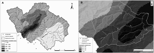
Comparing rainfall amounts, and their spatial variability, with discharge data permits cross-validation of the consistency of precipitation inputs and runoff response. Peak discharges estimated from high water marks surveyed after the flood (methods in CitationGaume & Borga, 2008) allow a useful comparison with rainfall inputs at the sub-basin scale. Peak discharge from post-flood field surveys in six sub-basins of the Pogliaschina basin was compared with peak discharge resulting from the application of a rainfall-runoff model calibrated in the Magra and Vara rivers for the flood of 25 October 2011 (details in CitationAmponsah et al., 2016) (). Model results show a satisfactory agreement with post-flood field estimates, with peak discharge within the uncertainty range of field estimations in four out of the six sub-basins. The representation of event precipitation featuring the lowest rainfall heights in the southern sector of the Pogliaschina basin (Figure 3 of CitationBartelletti et al., 2017) does not agree with extreme runoff response arising from post-flood estimates of peak discharge, which were corroborated by hydrological modelling implemented at the wider scale of the Magra River basin (CitationAmponsah et al., 2016).
Table 1. Cumulative event rainfall and peak discharge for six sub-basins in the Pogliaschina basin.
The representation of event rainfall has consequences for the interpretation of landslide distribution in the Pogliaschina basin. CitationBartelletti et al. (2017) ascribe the low ratio of landslide area to the formation area of the Macigno to ‘the relatively less intense rainfall that hit the area where this formation crops out’. Based on the analysis of rainfall and resulting discharge, this comment argues that the isohyet map indicating less intense rainfall in the southern sector of the Pogliaschina basin does not provide a satisfactory representation of rainfall distribution for the rainstorm of 25 October 2011.
The question then arises concerning an explanation for the limited occurrence of landslides in the sector that includes sub-basins 3, 4 and 5, mostly underlain by the Macigno formation, in spite of high rainfall amounts and not because of low rainfall amounts. Such an interpretation is outside the scope of this short note, which focuses on the importance of using all available information on precipitation distribution and height, including the valuable contribution of weather radar observations to help overcome the limitations of point measurements from rain gauges. The cross-validation of event rainfall and peak discharge, performed using rainfall-runoff models, is therefore recommended for confirming the spatial and temporal distribution of event rainfall when considering landslide occurrence.
Disclosure statement
No potential conflict of interest was reported by the author.
ORCID
Lorenzo Marchi http://orcid.org/0000-0003-0499-2556
References
- Amponsah, W., Marchi, L., Zoccatelli, D., Boni, G., Cavalli, M., Comiti, F., … Borga, M. (2016). Hydro-meteorological characterisation of a flash flood associated with major geomorphic effects: Assessment of peak discharge uncertainties and analysis of the runoff response. Journal of Hydrometeorology, 17, 3063–3077. doi: 10.1175/JHM-D-16-0081.1
- Bartelletti, C., Giannecchini, R., D’Amato Avanzi, G., Galanti, Y., & Mazzali, A. (2017). The influence of geological–morphological and land use settings on shallow landslides in the Pogliaschina T. basin (northern Apennines, Italy). Journal of Maps, 13, 142–152. doi: 10.1080/17445647.2017.1279082
- Borga, M., Boscolo, P., Zanon, F., & Sangati, M. (2007). Hydrometeorological analysis of the August 29, 2003 flash flood in the eastern Italian Alps. Journal of Hydrometeorology, 8, 1049–1067. doi: 10.1175/JHM593.1
- Fuhrmann, C. M., Konrad, C. E., & Band, L. E. (2008). Climatological perspectives on the rainfall characteristics associated with landslides in western North Carolina. Physical Geography, 29, 289–305. doi: 10.2747/0272-3646.29.4.289
- Gaume, E., & Borga, M. (2008). Post-flood field investigations in upland catchments after major flash floods: Proposal of a methodology and illustrations. Journal of Flood Risk Management, 1, 175–189. doi: 10.1111/j.1753-318X.2008.00023.x
- Rinaldi, M., Amponsah, W., Benvenuti, M., Borga, M., Comiti, F., Lucía, A., … Surian, N. (2016). An integrated approach for investigating geomorphic response to extreme events: Methodological framework and application to the October 2011 flood in the Magra River catchment, Italy. Earth Surface Processes and Landforms, 41, 835–846. doi: 10.1002/esp.3902