
ABSTRACT
A detailed, 1:10,500-scale, surficial geology and glacial geomorphology map of Svínafellsjökull and Virkisjökull-Falljökull glacier forelands in southeast Iceland depicts the landsystem imprint of Holocene glacier fluctuations, volcanogenic outburst floods and recent (post-1990) climate-induced rapid ice-front retreat. The map is based on field survey data in combination with 2012 airborne LiDAR data, 2009–2012 terrestrial LiDAR data and 2007 colour aerial photography. The base digital elevation model (DEM) is compiled from an ice-cap wide airborne LiDAR dataset. The mapped glacial landforms are dominated by sequences of recessional moraines laid down in the mid-Holocene, the Little Ice Age, and the last ∼100 years; the state of landform preservation generally decreasing with age. Interspersed with glaciofluvial sedimentation associated with typical ice-marginal retreat sequences is key geomorphological evidence of high-magnitude volcanogenic outburst floods (jökulhlaups) associated with the eruptions of Öraefajökull in 1362 and 1727 CE. Ice-front retreat has accelerated since c.2005 leaving a rapidly evolving buried-ice landscape in front of Virkisjökull-Falljökull – including an ice-cored esker, a large ice-floored (supraglacial) lake, and numerous actively forming kettle holes and ice caverns. This map could act as a ‘reference frame’ for geomorphologists studying the temporal evolution of glacial landform-sediment assemblages undergoing rapid change.
1. Introduction
The glaciated region of southern Iceland has been the subject of detailed glaciological and geomorphological research for over a century (e.g. CitationBjörnsson, 1998; CitationEvans et al., 2012; CitationHowarth & Welch, 1969a, Citation1969b; CitationThorarinsson, 1956). The mountain massifs support three principle ice caps, Eyjafjallajökull and Mýrdalsjökull and, in the southeast, Vatnajökull, Europe’s largest ice cap at c.8000 km2. The geomorphological imprints of the formerly more extensive ice caps and their outlet glaciers are to be found, often clearly preserved, in a narrow strip of land between the mountains and the North Atlantic. In southeast Iceland, under equilibrium conditions, high snow accumulation is balanced by high ablation (melting), leading to glaciers with high mass turnover that are sensitive to fluctuations in climate, whereby a relatively small change in temperature or precipitation is quickly transmitted as a shift in glacier dynamics. The relative accessibility of southeast Iceland’s glaciers and the preservation of their landscape legacy have enabled the development of a deeper understanding of glacial and glacial geomorphic processes and continue to encourage new research (e.g. CitationBoulton & Hindmarsh, 1987; CitationEyles, 1979; CitationHannesdóttir, Björnsson, Pálsson, Aðalgeirsdóttir, & Guðmundsson, 2015a, Citation2015b; CitationPhillips, Finlayson, Bradwell, Everest, & Jones, 2014; CitationSpedding & Evans, 2002).
The rapidity of change in glacial systems enables real-time (geomorphological) process-landform studies to be carried out. To this end, an extensive sensor network was established by the British Geological Survey (BGS) at Virkisjökull-Falljökull in SE Iceland in 2009, forming the basis of the ‘Glacier Observatory Project’ (http://www.bgs.ac.uk/research/glaciermonitoring/home.html). As part of this work, detailed mapping has been carried out providing high-resolution digital records of the landscape morphology, and interpretations of its genesis, age and evolution (see Main Map). The mapping supports other Observatory research being carried out at the glacier (e.g. CitationBradwell, Sigurðsson, & Everest, 2013; CitationFlett et al., 2017; CitationKrabbendam, Bradwell, Everest, & Eyles, 2017; CitationMacDonald et al., 2016; CitationPhillips, Finlayson, & Jones, 2013, Citation2014, Citation2017).
2. Study site
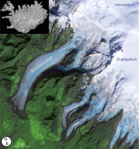
Both Svínafellsjökull and Virkisjökull-Falljökull are western outlet glaciers of the Öræfajökull ice cap (2110 m above sea level (a.s.l.)), an almost isolated subsidiary ice cap within the Vatnajökull complex (), feeding nine principal outlet glaciers. Svínafellsjökull is c.10 km long and <2 km wide throughout its length, and is backed by a steep icefall, with its lower reaches characterised by generally low gradients. Virkisjökull-Falljökull lies to the south of Svínafellsjökull, and by contrast has a more complex hypsometry. From the crater lip, the glacier bisects into two arms around the Rauðikambur nunatak, the northern arm forming Virkisjökull, and the southern Falljökull. The hypsometries of these two essentially separate glaciers are quite different, with Virkisjökull possessing a stepped icefall, and a relatively low-gradient lower portion; and Falljökull having a single icefall and a relatively steeper, but shorter lower portion. The two glaciers recombine below Rauðikambur at 210 m, and their margins terminate at a proglacial lake at 130 m. Both arms of the glacier support a large proportion of debris-covered ice, which manifests itself as relatively higher elevation areas of the glacier (20–30 m above clean ice).
Figure 1. Virkisjökull-Falljökull and Svínafellsjökull glaciers, outlets of the Öræfajökull ice cap at the southern extremity of Vatnajökull, with Iceland inset.
3. Historical evolution of Svínafellsjökull and Virkisjökull-Falljökull
3.1. Svínafellsjökull
Prior to Norse settlement of Iceland (c.900 CE (Common Era)) little is known about the extent and thickness of Öræfajökull’s outlet glaciers. Pioneering tephrochronological investigations by CitationThorarinsson (1956) showed that mature soils on the outermost old moraine, known as Stóralda, pre-dated the Ö-1362 eruption and therefore probably relate to a pre-historic glacier fluctuation of Svínafellsjökull. CitationGudmundsson (1998) constrained this glacial advance event more precisely to between 800 and 740 BP (1200–1362 CE). Other geomorphological evidence for earlier Holocene fluctuations of Svínafellsjökull has probably been removed by erosion from meltwater rivers, although subtle lateral limits may lie on the flanks of Svínafellsheiði.
The recent ice-front fluctuations and history of landform development at Svínafellsjökull are relatively well known (CitationHannesdóttir et al., 2015a, Citation2015b; CitationSigurdsson, 1998; CitationThompson, 1988; CitationThorarinsson, 1943). During the Little Ice Age (LIA – eighteenth and nineteenth centuries) and first few years of the twentieth century, the terminus of Svínafellsjökull extended well beyond its present-day position where it coalesced with the neighbouring Skaftafellsjökull until 1935 (CitationThompson, 1988; CitationThorarinsson, 1943). Since that time, overall retreat of the Svínafellsjökull ice-front, totalling around ∼500 m, has been punctuated by numerous minor oscillations and stillstands (CitationThompson, 1988). These ice-front fluctuations have resulted in a distinct suite of large, concentric, occasionally sawtooth, moraines on the foreland immediately adjacent to the glacier. Between c.1970 and 2000, the position of the ice front remained stable, with little or no overall net movement (CitationHannesdóttir et al., 2015a). Renewed glacier recession has occurred since c.2000, accelerating since 2010, accompanied by pronounced thinning of the terminal zone.
3.2. Virkisjökull-Falljökull
Although monitored and routinely measured every year since 1932 by the Icelandic Glaciological Society, the historical evolution of Virkisjökull-Falljökull (prior to the mid-twentieth century) has not been subject to detailed study or resulted in a published glacier reconstruction (cf. CitationHannesdóttir et al., 2015a, Citation2015b). However, reference to the twin glaciers has been made by various workers undertaking wider glacier-evolution studies.
CitationGudmundsson (1998) mapped old subdued moraines relating to Virkisjökull-Falljökull on the western flanks of Sandfellsheiði, to which he ascribed mid-Holocene ages (5000–6000 BP), inferring an ice limit 2–3 km beyond the present-day margin at ∼70 m a.s.l. Isolated moraine mounds with thick soil sequences close to the main road probably relate to this early-mid Holocene advance. Around 1.5–2 km up-valley of these fragmentary moraines lies a suite of well-preserved sharp-crested moraines with complex geomorphology. Although currently undated, the absence of thick soils and tephras between them led CitationGudmundsson (1998) to ascribe them to the LIA period. Lichenometric dating carried out on these moraines by CitationBradwell (1998), and CitationChenet, Roussel, Jomelli, and Grancher (2010) yielded data consistent with moraine formation in the last 200–300 years. The LIA moraine chronology at Virkisjökull-Falljökull is still uncertain. Unlike most other outlet glaciers in southeast Iceland (e.g. Skaftafellsjökull; Fjallsjökull, and Kviarjökull), the LIA maximum glacier extent has not been unequivocally defined (Hannesdóttir et al., Citation2015a). The authors have not found any historical maps, documents, or published photographs relating to the timing of LIA maximum glacier advance, although the glacier was well advanced in the earliest topographic maps of the region (Danish General Staff, Citation1904). We assume that Virkisjökull-Falljökull probably reached its maximum LIA extent c.1870–1890 AD in sympathy with the adjacent glaciers draining the Öræfajökull volcano (Hannesdóttir et al., Citation2015a). Further research to better constrain the age of the moraines and related features at Virkisjökull-Falljökull is ongoing.
Data relating to the mid–late twentieth-century fluctuations of Virkisjökull-Falljökull have been published by CitationBradwell et al. (2013). Their work quantifies the most recent rates of change (since 2005) and explores their cause, placing these rapid changes in a longer term (∼80 years) context.
4. Methods
4.1. Field mapping
Geomorphological investigations and field mapping have been carried out by the authors since 1996, and annually or biennially since the establishment of the BGS Glacier Observatory in 2009. Over this time, extensive geomorphological and surficial geological field surveys have been conducted of the entire mapped area alongside LiDAR and helicopter drone surveys.
Construction of broad age categories for geomorphic units at both glaciers is based mainly on published work (e.g. CitationBradwell, 1998; CitationThompson, 1988; CitationThorarinsson, 1956), but has been supplemented by field data, including lichenometric ages (see CitationBradwell, 2001, Citation2004 for detailed methods). Sedimentological logging of exposed sections in surficial deposits has allowed their distribution and thicknesses to be determined in many locations.
4.2. Terrestrial LiDAR scanning
The advent of Terrestrial LiDAR Scanning (TLS) has provided a means to create extremely high-resolution surface Digital Elevation Models (DEMs) of landscapes and structures. Sub-centimetre scale resolution models of large landscape areas are now possible. Multiple scans produced by BGS from different years were used to construct the DEM for Virkisjökull-Falljökull.
4.3. Remote sensing data sources
Outwith the area scanned by the BGS around the margin of Virkisjökull-Falljökull, two separate remotely acquired datasets have been used.
4.3.1. Airborne LiDAR DEM
The DEM which forms the basemap to the surficial and geomorphological map presented here was created by the Veðurstofa Íslands (Icelandic Meteorological Office – IMO) and the Institute of Earth Sciences, University of Iceland, and is part of the Öræfajökull dataset, collected in 2012. The DEM was produced from ground positions derived from the laser with an average measurement point density of 0.33 m2, i.e. approximately one measurement every 3 m2. These measurements were averaged and interpolated onto a regular 5 m × 5 m grid (DEM). Further information regarding the collection and processing of these data can be found in CitationJóhannesson et al. (2013).
4.3.2. Aerial photography
A set of 1:10,000 scale colour aerial photographs (numbers 20070802-006609 to 006614, and 006620 to 006623, NERC ARSF, 2007) were mosaicked and georectified using ERDAS Imagine and ArcGIS, and overlain on the DEM surfaces. To establish the ages of recent key geomorphological features (post-1950), historical (vertical) aerial photography from Landmælingar Íslands has been used (1954, 1982, 1988, 1992, 1997).
4.4. Map design and software
The map (see Main Map) was constructed using the BGS:SIGMA digital data capture system, which is based on ESRI ArcGIS©. This enables the collection of geological point, line and polygon data both in the field and subsequently as a desktop application. SIGMA was set up using the GCS ISN1993 coordinate system and D-Islands Network1993 datum. Field data were overlain on two separate hillshade models, derived from the IMO and BGS DEMs, each lit from 045° and 315° to avoid illumination bias. The aerial photograph mosaic was overlain on these hillshade models.
To avoid discrepancies between the 2007 aerial photography and the 2012 IMO and BGS DEMs, photography was not used in areas where significant landscape change could be seen between these aerial photographs and the more recent DEM coverage. The only significant areas affected by this were the glacier margins and immediate forelands.
Mapping was carried out using the broad categories of deposits and landforms established by CitationHowarth and Welch (1969a, Citation1969b) as these have seen continued usage for example by CitationEvans and Twigg (2002) and others. This system was chosen to simplify comparison with other glacial geomorphological maps of Iceland. Once complete, map layers (DEMs, linework and polygons) were then exported to Adobe Illustrator CS6 for construction of the final map and marginalia.
5. Glacial geomorphology and surficial geology
Twenty-three mapping units are identified on the glacier forelands and intervening upland ground. Map unit colours and landform symbology follow those used for previous Icelandic glacier foreland maps (CitationBennett, Evans, Carbonneau, & Twigg, 2010; Evans, Shand, & Petrie Citation2009, Citation2010; CitationEvans & Twigg, 2002; Evans, Twigg, Rea, & Orton, Citation2009; CitationEvans, Twigg, & Shand, 2006, Citation2007; CitationHowarth & Welch, 1969a, Citation1969b), and nomenclature based on the BGS Lexicon of Superficial Deposits (CitationMcMillan & Powell, 1999).
5.1. Bedrock at or near surface
The Öræfajökull volcano consists mainly of basaltic hyaloclastites, tuffs and lava flows with minor rhyolitic intrusions Citation(Krabbendam et al., 2017; CitationPrestvik, 1979; CitationStevenson, McGarvie, Smellie, & Gilbert, 2006). In the region of Svínafellsjökull and Virkisjökull-Falljökull, these units dip broadly westwards away from the summit of Öræfajökull, and are extensively exposed on the steep ground above the glaciers.
5.2. Soil
On the north-western facing flanks of Svínafellsheiði are remnant patches of aeolian (tephra) deposits and thick peat, up to 100 m across, and in some instances >2 m thick. These have suffered extensive deflation and show marked cuspate edges. Soils are also locally preserved in small isolated hollows across most of the gentler gradient lower slopes.
5.3. Periglacially modified sediments
Periglacial processes are widespread above c.180 m a.s.l. where many surfaces supporting loosely consolidated materials such as soils or tills display landforms and patterning associated with cryoturbation. Across Skerhóll, Svínafellsheiði and Sandfellsheiði are extensive areas of weathered, periglacigenic material, incorporating blockfields, solifluction lobes and stone stripes.
5.4. Talus and talus cone deposits
Small areas of talus (scree) are very common, and occur on most slopes as the products of mechanical weathering of exposed bedrock. These deposits do not maintain significant thicknesses. As a result, only larger talus deposits have been mapped. Where these deposits coalesce to cover large areas they have been mapped separately as talus cone deposits. In some areas, these deposits form relatively thick accumulations (>5 m) of talus material.
5.5. Rock slope failure deposits
Rock slope failures are relatively common in the area. A failure from Hnúta onto Virkisjökull of c.100,000 m3 took place in 2011. The deposit, comprising a heterogeneous accumulation of sand, gravel, cobbles and boulders up to 20 m in diameter, has caused insulation of the underlying ice, resulting in the insulated ice surface standing c.20 m above surrounding clean ice by 2016. The smaller of the two rock slope failure deposits mapped occurs on Svínafellsjökull below cliffs down-ice of Fremrimenn.
5.6. Glacigenic debris flow deposits
The ice-distal slope of the twentieth-century moraines at Svínafellsjökull is draped with a low-angled wedge of mass movement material, interpreted as remobilised till and deposited as glacially derived coalescent debris flow units. These cover the slope to an unknown depth and display a smooth upper surface, dipping at c.5°, and onlap the ice-proximal slope of the pre-twentieth-century Stóralda moraines.
5.7. Glacier lake and deposits
Glaciolacustrine sediments comprising well-bedded, fine- to coarse-grained sands, silts and mud are seen in several basins within the twentieth-century moraines at Svínafellsjökull. A number of these older basins currently support lakes. Modern proglacial lakes occur close to the margins of both Svínafellsjökull and Virkisjökull-Falljökull. Evolution of these modern lakes is complex. For example, the proglacial lake at Virkisjökull-Falljökull is floored by buried ice, and is subject to fluctuations in water level and sedimentation due to inflow from a combination of glacier melt and rainwater, entering the lake both over the surface, and also through englacial conduits which continue in the buried ice beneath the lake surface (CitationBradwell et al., 2013; CitationFlett et al., 2017; CitationMacDonald et al., 2016).
5.8. Alluvial cone deposits
An alluvial debris cone, comprising sub-angular to sub-rounded pebble and gravel grade material, is found immediately to the northwest of Sandfells churchyard, issuing from Stóralækjarglúfur, which drains Sandfellsheiði. This stream has had no direct glacial source since prior to the twentieth century (inferred from air photography).
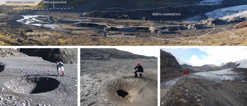
5.9. Buried-ice moraine
The immediate proglacial areas of both glaciers are characterised by slowly downwasting buried glacier ice (a–d) (CitationBradwell et al., 2013; CitationEverest & Bradwell, 2003). It has been shown that this buried-ice terrain supports a network of linked cavities and channels, behaving in a similar manner to a karstic drainage network (CitationFlett et al., 2017; CitationMacDonald et al., 2016). Landform suites elsewhere in southern Iceland indicate that the process of topographic inversion as a result of subaerial buried-ice melting produces a ‘hummocky’ morainic system (CitationEverest & Bradwell, 2003; CitationEyles, 1979). At Virkisjökull-Falljökull, the generation of hummocky moraine is unlikely as the buried ice occupies an overdeepened trough currently hosting a proglacial lake.
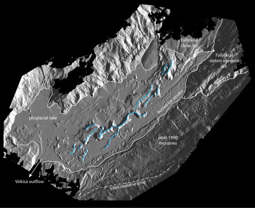
Figure 2. (a) Proglacial area of Virkisjökull-Falljökull, characterised by surface sediments overlying inactive, downwasting buried ice. Fine dashed line indicates boundaries between this buried ice and the more active ice of the glacier margins, and the surrounding moraine-covered slopes. Large dashed line indicates the crest of the most recent maximum limit of ice advance in 1990. Locations of b, c and d images are also indicated; (b) sinkhole within the buried ice sandur, caused by melting of the underlying ice by meltwater flow through a conduit system; (c) first stage of sinkhole development. The sandur in the background undergoes inundation during high rainfall events; (d) crest of the englacial esker, looking back towards the clean ice margin of Falljökull. Bedded sediments can be seen exposed on the esker flank.
5.10. Moraines and associated deposits
For the purposes of this description, moraine deposits include the tills found in the forelands of both glaciers. Typically, these tills are thin, being less than 1 m thickness in the most recently deglaciated foreland at Virkisjökull-Falljökull, and less than 3 m proglacial to Svínafellsjökull, though locally thicker deposits are found forming the basal units of the larger moraine features. These deposits are primarily composed of subglacial traction till (deposited by the base of the glacier by pressure melting or by shearing of substrate sediments by overriding) and sediment melted out of inactive or slow-moving debris-rich ice, and directly deposited without subsequent transport or deformation (CitationEvans, 2000; CitationEvans, Phillips, Hiemstra, & Auton, 2006).
5.10.1. Very recent moraines: 1990–present
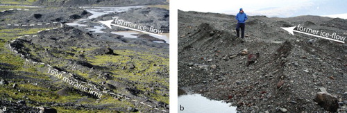
Both glacier forelands support areas of highly complex, densely spaced, relatively high relief low elevation gravelly ridges. At Virkisjökull-Falljökull, these record rapid retreat from the most recent maximum glacier extent in c.1990 (CitationBradwell et al., 2013), and form ice margin-parallel ridges between 0.5 and 2 m high. These are composed primarily of sand, gravel and boulders, and form locally interrupted moraine suites, recording small fluctuations of the margin over seasonal and shorter timescales (a). At Svínafellsjökull, recent moraines typically display characteristic sawtooth or crenulated plan form, recording their formation along an irregular, longitudinally crevassed margin (b), and are composed of finer material than those at Virkisjökull-Falljökull.
Figure 3. (a) Recent moraines at Virkisjökull-Falljökull, dashed line indicates the 1990 moraine limit, the partially flooded area of buried-ice moraine can be seen in the upper right of the image; (b) Recent moraines at Svínafellsjökull, displaying ‘push moraine’ style cross-sectional form, and ‘sawtooth’ planforms.
5.10.2. LIA moraines to 1990
These broad zones of composite moraine ridge features dominate the forelands of both glaciers, standing up to 60 m above the adjacent sandur at Svínafellsjökull and up to 80 m at Virkisjökull-Falljökull. The Svínafellsjökull moraines are a complex series of large push moraines, composed largely of englacial and supraglacial material; however, these purely glacigenic units often occur with units composed primarily of reworked glaciofluvial material (CitationThompson, 1988). The Svínafellsjökull moraines are dominated by four and in some places five prominent ridges, marking positions of relatively major readvances. CitationThompson (1988) attributes ages of 1904, 1930, 1945 and 1954 to these composite moraine features, with the innermost high moraine crest being reoccupied in 1964 and 1988–1990. Between the more prominent ridge crests, moraines are crenulated in planform, reflecting deposition at the highly crevassed ice margin (a).
Figure 4. (a) Twentieth-century moraines at Svínafellsjökull, looking towards Skaftafellsjökull; (b) twentieth-century lateral moraines at Falljökull; (c) buried ice hollows within the twentieth-century moraines at Virkisjökull.
The moraines outside the very distinctive 1990 limit at Virkisjökull-Falljökull show a more dissected and asymmetric planform morphology than those at Svínafellsjökull. A large moraine complex bounds the glacier to the south, and is composed of long, highly linear latero-frontal moraines (b). However, distal to the modern and 1990 margin of the glacier, this linearity breaks down somewhat. The moraines, though still clearly delineating former marginal positions, have been extensively eroded by outwash, and in places exhibit atypical cross-sectional morphology, reflecting a combination of the influences of the valley architecture, being bounded to the north by the near vertical cliff, Hnúta, thus limiting sediment supply, but also the former presence of large masses of buried ice in the north-western portions of the moraine (CitationEverest & Bradwell, 2003). These have led to significant topographic inversion of former moraine surfaces (c).
The Virkisjökull-Falljökull moraines are primarily composed of well-rounded cobbles, sand, gravel and silt, with common large boulders (up to 5 m high, though more commonly <1 m3).
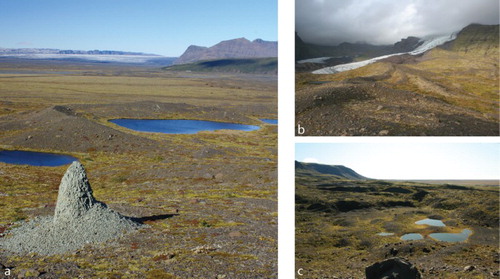
5.10.3. Pre-LIA moraines
Both glacier forelands contain moraines that pre-date the LIA glacier advance (broadly agreed to have occurred c.1600–1850; CitationOerlemans, 2005). The Stóralda moraine at Svínafellsjökull is well documented (CitationGudmundsson, 1998; CitationThompson, 1988; CitationThorarinsson, 1956). This well vegetated, soil covered moraine remnant is situated some 100 m distal to the outer edge of the 1870 moraines, separated from them in part by the slope of glacigenic debris flow deposits. Stóralda comprises a higher proximal ridge, with several lower elevation ridges located on the distal flank.
To the southwest of the larger twentieth-century moraines at Virkisjökull-Falljökull are several small isolated remnants of previously larger moraines which are surrounded by more recent sandur deposits. These moraines form broad-crested, low elevation ridges, running sub-parallel to modern ice flow. They are well vegetated, and have generally well-developed soils. A second suite of moraines occur between 180 and 230 m a.s.l., to the south of the Falljökulskvísl gorge on the lower flanks of Sandfellsheiði. Their upper surfaces display evidence of significant periglacial alteration. None of these moraines have been directly dated; however, tephrochronological studies on the Sandfellsheiði moraines showed that they are probably mid to early Holocene in age (>5 ka BP) (CitationGudmundsson, 1998) and certainly pre-date the LIA.
5.11. Esker deposits
Between 2005 and 2016, a prominent esker ridge exited the clean ice margin of Falljökull (a,d). This broadly ice flow-parallel, NE to SW trending ridge, comprised an ice core enclosed with a mantle of glaciofluvial sediments varying in thickness from <1 m to over 3 m. The esker has been surveyed annually by the BGS, using TLS (), and its evolution over time is the subject of ongoing research by the authors. In 2012, the esker displayed a distinct sinuous planform with an average long profile surface gradient of 1°–2°, dipping to the southwest, closely reflecting the original englacial meltwater channel into which the sediments were initially deposited. The sediments are characterised by interbedded, well-sorted, prograding (cross-bedded) sand and gravel units, reflecting variations in channel discharge. At the time of submission of this article, the esker has all but disappeared and the foreland is now flooded as the ice core has melted.
Figure 5. Hillshade surface derived from Terrestrial LiDAR-derived Digital Elevation Model, showing the relationship of the esker (blue line) to the margin of Falljökull and the buried-ice moraine in the proglacial area (within white line marked ‘buried ice sandur’).
5.12. Glaciofluvial outwash/sandur deposits
The forelands of Svínafellsjökull and Virkisjökull-Falljökull are dominated by extensive glacial outwash sands and gravels or sandur. These occur either as coalescent proglacial outwash fans, which extend westwards towards the coast, or as narrow strips of ribbon sandur deposited in channels incised through areas of upstanding moraines. The sandur surfaces represent the evolution of the proglacial drainage systems of both glaciers, and here we make subdivisions of these surfaces into ‘active’, ‘Post-1990’, ‘Little Ice Age to 1990’ and ‘Pre-Little Ice Age’ surfaces. These subdivisions are based on geomorphological observations collected by the authors since 1996, supplemented by historical aerial photography and recent LiDAR DEMs. Where genesis of a surface cannot be determined from these sources, general field relationships and vegetation development have been used to infer an age.
In broad terms, sandur deposits are comprised of interbedded sands, gravels and cobbles occasionally well-sorted with a high proportion of rounded and sub-rounded clasts; the composition of each bed reflecting flow regime at the time of deposition. Significant reworking downstream results in a general fining of clasts with distance from the glacial and paraglacial source areas.
5.13. Jökulhlaup deposits
On the low ground in front of Virkisjökull-Falljökull, we have classified and mapped a different type of sandur deposit relating to high-energy volcanogenic glacier-outburst floods (jökulhlaups). This classification is based on aerial photography mapping and fieldwork (between 2009 and 2012) using established criteria for the recognition of jökulhlaup deposits (e.g. CitationMaizels, 1997); but also draws on documentary evidence of flood timing and routing following the devastating 1362 and 1727 eruptions of Öræfajökull (CitationRoberts & Gudmundsson, 2015; CitationThorarinsson, 1958).
To the west of the Virkisjökull LIA moraine complex, extremely large boulders up to 10 m in length, and 400 m3 in volume (such as the Smjörsteinn or Butter Stone), are situated on relatively well-vegetated ground at a slightly higher elevation (<1 m) than the surrounding sandur. This discrete area forms a broad fan 1.5 km wide which appears to onlap the adjacent non-glaciofluvial sediments now supporting the farm holdings of Svínafell. In his authoritative review of all the evidence, CitationThorarinsson (1958) concluded that the 1362 jökulhlaup issued primarily from Virkisjökull-Falljökull, with the main route starting subaerially from a point on the western margin of Virkisjökull close to the foot of the Hnúta cliffs; a second route via Falljökull reached the sandur near Sandfell either via the Falljökulskvísl canyon or directly from the former margin of the glacier. CitationRoberts and Gudmundsson (2015) refine the maps of Thorarinsson, but come to very similar conclusions regarding the likely 1362 floodwater routes.
We map jökulhlaup deposits (most likely from the Ö-1362 flood) at both these places adjacent to Virkisjökull-Falljökull, based on geomorphological and sedimentological criteria – entirely consistent with the documentary evidence and previous research.
A subsequent volcanic eruption in 1727 resulted in a smaller but dynamically similar outburst flood from the Öræfajökull outlet glaciers. The exact route and extent of the 1727 hlaup floodwaters issuing from Virkisjökull-Falljökull is difficult to ascertain, but both CitationThorarinsson (1958) and Roberts and Gudmundsson (Citation2015) indicate that a proportion of the flood would have come from the margin of the glacier at the time. We have not distinguished between the 1362 vs 1727 jökulhlaup deposits, as we cannot assign definitive surface ages based on existing inconclusive geochronological data derived from lichenometric dating studies (CitationBradwell, 1998; CitationGudmundsson, 1998).
5.14. Alluvial deposits
This minor component of the map includes fluvial deposits filling localised drainage courses, mainly derived from non-glacial streams since deglaciation. Their distinction here is made owing to the lack of a glacial source, in contrast to the sandur deposits found more extensively across the area fronting the glaciers.
6. Conclusions
We have mapped and characterised the geomorphology and sediments of c.29 km2 of the forelands of Svínafellsjökull and Virkisjökull-Falljökull. These glaciers have left distinctive geomorphological hallmarks on the landscape, recording their behaviour over the last several millennia. In summary, the 1:10,500-scale map depicts the landsystem imprint of Holocene glacier fluctuations and outwash (sandur) sediment aggradation, and at Virkisjökull-Falljökull the legacy of volcanogenic outburst floods, and recent (post-1990) climate-induced rapid ice-front retreat. The map is based on field survey data collected between 1996 and 2015; 2012 airborne LiDAR data; 2009–2012 terrestrial LiDAR data; and 2007 colour aerial photography.
Based on this new mapping, we draw the following conclusions:
Both forelands are dominated by sequences of recessional moraines deposited when the glaciers were considerably more extensive than at present – in the mid-Holocene, and in the LIA – and a period of overall glacier recession spanning the last ∼100 years.
The degree of landform preservation generally decreases with age.
Interspersed with steady-state glaciofluvial sedimentation is geomorphological evidence of high-magnitude volcanogenic outburst floods (jökulhlaups) that issued from Virkisjökull-Falljökull. These were probably associated with the eruptions of Öræfajökull in 1362 and 1727 CE, but remain undated.
Special attention is drawn to an actively forming ice-cored esker, a large ice-floored (supraglacial) lake, numerous recently developed kettle holes and a system of ephemeral subterranean ice caverns.
We hope that this map will act as a ‘reference frame’ or ‘baseline marker’ for geomorphologists studying the temporal evolution of glacial landform-sediment assemblages, such as those in southeast Iceland.
SVINAFALL_Final_V3.pdf
Download PDF (9.5 MB)Acknowledgements
Thanks are due to Bergur Bergsson, Kristín Vogfjörð and Benedikt Gunnar Ófeigsson at Veðurstofa Íslands, and Ívar Örn Benediktsson of the Institute of Earth Sciences, University of Iceland, for his Icelandic translation on the map marginalia. The authors also thank Regína Hreinsdóttir at Vatnajökulsþjóðgarður, and the staff of Glacier Guides at Skaftafell. Our greatest thanks are due to the families of Svínafell, in particular to Óli Sigurðsson and Pálína Þorsteinsdóttir, without whose help, support and kindness, our work could never have taken place. This research forms part of the British Geological Survey Virkisjökull Monitoring Project, within the Earth Hazards and Observatories Directorate. This paper is published with the permission of the Executive Director of the British Geological Survey (NERC).
Disclosure statement
No potential conflict of interest was reported by the authors.
Additional information
Funding
Related Research Data
References
- Bennett, G. L., Evans, D. J. A., Carbonneau, P., & Twigg, D. R. (2010). Evolution of a debris-charged glacier landsystem, Kvíárjökull, Iceland. Journal of Maps, 2010, 40–76. doi: 10.4113/jom.2010.1114
- Björnsson, H. (1998). Hydrological characteristics of the drainage system beneath a surging glacier. Nature, 395, 771–774. doi: 10.1038/27384
- Boulton, G. S., & Hindmarsh, R. C. A. (1987). Sediment deformation beneath glaciers: Rheology and sedimentological consequences. J. Geophysical. Res., 92(B9), 9059–9082. doi: 10.1029/JB092iB09p09059
- Bradwell, T. (1998). Climate-induced 20th century glacier fluctuations in southeast Iceland. Frodskaparrit, 46, 319–332.
- Bradwell, T. (2001). A new lichenometric dating curve for Southeast Iceland. Geografiska Annaler: Series A, Physical Geography, 83, 91–101. doi: 10.1111/j.0435-3676.2001.00146.x
- Bradwell, T. (2004). Lichenometric dating in southeast Iceland: The size–frequency approach. Geografiska Annaler: Series A, Physical Geography, 86, 1.
- Bradwell, T., Sigurðsson, O., & Everest, J. (2013). Recent, very rapid retreat of a temperate glacier in SE Iceland. Boreas, 42, 959–973. doi: 10.1111/bor.12014
- Chenet, M., Roussel, E., Jomelli, V., & Grancher, D. (2010). Asynchronous Little Ice Age glacial maximum extent in Southeast Iceland. Geomorphology, 114, 253–260. http://doi.org/10.1016/j.geomorph.2009.07.012
- Danish General Staff. (1904). Sheet 87 SV, 1:50,000. Copenhagen: The topographic department of the Danish General Staff.
- Evans, D. J. A. (2000). A gravel outwash/deformation till continuum, Skalafellsjökull, Iceland. Geografiska Annaler, 82A, 499–512. doi: 10.1111/j.0435-3676.2000.00137.x
- Evans, D. J. A., Phillips, E. R., Hiemstra, J. F., & Auton, C. A. (2006). Subglacial till: Formation, sedimentary characteristics and classification. Earth Science Reviews, 78, 115–176. doi: 10.1016/j.earscirev.2006.04.001
- Evans, D. J. A., Shand, M., & Petrie, G. (2009). Maps of the snout and proglacial landforms of Fjallsjökull, Iceland (1945, 1965, 1998). Scottish Geographical Journal, 125, 304–320. doi: 10.1080/14702540903364310
- Evans, D. J. A., & Twigg, D. R. (2002). The active temperate glacial landsystem: A model based on Breiðamerkurjökull and Fjallsjökull, Iceland. Quaternary Science Reviews, 21, 2143–2177. doi: 10.1016/S0277-3791(02)00019-7
- Evans, D. J. A., Twigg, D. R., & Orton, C. (2010). Satujökull glacial landsystem, Iceland. Journal of Maps, 6, 639–650. doi: 10.4113/jom.2010.1129
- Evans, D. J. A., Twigg, D. R., Rea, B. R., & Orton, C. (2009). Surging glacier landsystem of Tungnaárjökull, Iceland. Journal of Maps, 5, 134–151. doi: 10.4113/jom.2009.1064
- Evans, D. J. A., Twigg, D. R., Rea, B. R., & Shand, M. (2007). Surficial geology and geomorphology of the Bruarjökull surging glacier landsystem. Journal of Maps, 3, 349–367. doi: 10.1080/jom.2007.9710850
- Evans, D. J. A., Twigg, D. R., & Shand, M. (2006). Surficial geology and geomorphology of the Þorisjökull plateau icefield, west-central Iceland. Journal of Maps, 2, 17–29. doi: 10.4113/jom.2006.52
- Evans, D. J. A., Twigg, D. R., & Shand, M. (2012). Surficial geology and geomorphology of the þórisjökull plateau icefield, west-central Iceland. Journal of Maps, http://doi.org/10.4113/jom.2006.52
- Everest, J., & Bradwell, T. (2003). Buried glacier ice in southern Iceland and its wider significance. Geomorphology, 52(3), 347–358. doi: 10.1016/S0169-555X(02)00277-5
- Eyles, N. (1979). Facies of supraglacial sedimentation on Icelandic and Alpine temperate glaciers. Canadian Journal of Earth Sciences, 16, 1341–1361. doi: 10.1139/e79-121
- Flett, V., Maurice, L., Finlayson, A., Black, A. R., MacDonald, A. M., Everest, J., & Kirkbride, M. P. (2017). Meltwater flow through a rapidly deglaciating glacier and foreland catchment system: Virkisjökull, SE Iceland. Hydrology Research Feb 2017, nh2017205. doi: 10.2166/nh.2017.205
- Gudmundsson, H. J. (1998). Holocene glacier fluctuations and tephrochronology of the Öraefi district, Iceland (Unpublished PhD thesis). University of Edinburgh.
- Hannesdóttir, H., Björnsson, H., Pálsson, F., Aðalgeirsdóttir, G., & Guðmundsson, S. (2015a). Variations of southeast Vatnajökull ice cap (Iceland) 1650–1900 and reconstruction of the glacier surface geometry at the little Ice Age maximum. Geografiska Annaler: Series A, Physical Geography, 97(2), 237–264. doi: 10.1111/geoa.12064
- Hannesdóttir, H., Björnsson, H., Pálsson, F., Aðalgeirsdóttir, G., & Guðmundsson, S. (2015b). Changes in the southeast Vatnajökull ice cap, Iceland, between ∼1890 and 2010. The Cryosphere, 9(2), 565–585. doi: 10.5194/tc-9-565-2015
- Howarth, P. J., & Welch, R. (1969a). Breiðamerkurjökull, South-east Iceland, August 1945. 1:30,000 scale map. Glasgow: University of Glasgow.
- Howarth, P. J., & Welch, R. (1969b). Breiðamerkurjökull, South-east Iceland, August 1965. 1:30,000 scale map. Glasgow: University of Glasgow.
- Jóhannesson, T., Björnsson, H., Magnússon, E., Guðmundsson, S., Pálsson, F., Sigurðsson, O., … Berthier, E. (2013). Ice-volume changes, bias estimation of mass-balance measurements and changes in subglacial lakes derived by Lidar mapping of the surface of Icelandic glaciers. Ann. Glaciology., 63, 63–74. doi: 10.3189/2013AoG63A422
- Krabbendam, M., Bradwell, T., Everest, J., & Eyles, N. (2017). Joint-bounded crescentic scars formed by subglacial clast-bed contact forces: Implications for bedrock failure beneath glaciers. Geomorphology, 290, 114–127. doi: 10.1016/j.geomorph.2017.03.021
- MacDonald, A. M., Black, A. R., Ó Dochartaigh, B. É., Everest, J., Darling, W.G., Flett, V., & Peach, D.W. (2016). Using stable isotopes and continuous meltwater river monitoring to investigate the hydrology of a rapidly retreating Icelandic outlet glacier. Annals of Glaciology, 57(72), 151–158. doi:10.1017/aog.2016.22.
- Maizels, J. (1997). Jökulhlaup deposits in proglacial areas. Quaternary Science Reviews, 16(7), 793–819. doi: 10.1016/S0277-3791(97)00023-1
- McMillan, A. A., & Powell, J. H. (1999). BGS Rock Classification Scheme. Vol. 4. Classification of artificial (man-made) ground and natural superficial deposits-applications to geological maps and datasets in the UK (British Geological Survey Research Report 99-04).
- Oerlemans, J. (2005). Extracting a climate signal from 169 glacier records. Science, 308, 675–677. doi: 10.1126/science.1107046
- Phillips, E., Everest, J., Evans, D. J. A., Finlayson, A., Ewertowski, M., Guild, A., & Jones, L. (2017). Concentrated, “pulsed” axial glacier flow: Structural glaciological evidence from Kvíárjökull in SE Iceland. Earth Surface Processes and Landforms. doi: 10.1002/esp.4145
- Phillips, E., Finlayson, A., Bradwell, T., Everest, J., & Jones, L. (2014). Structural evolution triggers a dynamic reduction in active glacier length during rapid retreat: Evidence from Falljökull, SE Iceland. Journal of Geophysical Research Earth Surface, 119, 2194–2208. doi: 10.1002/2014JF003165
- Phillips, E., Finlayson, A., & Jones, L. (2013). Fracturing, block faulting, and moulin development associated with progressive collapse and retreat of a maritime glacier: Falljökull, SE Iceland. Journal of Geophysical Research Earth Surface, 118, 1545–1561. doi: 10.1002/jgrf.20116
- Prestvik, T. (1979). Geology of the Öræfi district, southeastern Iceland (Nordic Volcanological Institute Report 79-01).
- Roberts, M. J., & Gudmundsson, M. T. (2015). Öræfajökull volcano: Geology and historical floods. In E. Pagneux (Ed.), Volcanogenic floods in Iceland: An assessment of hazards and risks at Öræfajökull and on the Markarfljot outwash plain (pp. 17–44). Reykjavik: IMO, IES-UI, NCIP-DCPEM.
- Sigurdsson, O. (1998). Glacier variations in Iceland 1930-1995: From the database of the Iceland Glaciological Society. Jökull, 45, 3–26.
- Spedding, N., & Evans, D. J. (2002). Sediments and landforms at Kvíárjökull, southeast Iceland: A reappraisal of the glaciated valley landsystem. Sedimentary Geology, 149(1), 21–42. doi: 10.1016/S0037-0738(01)00242-1
- Stevenson, J., McGarvie, D., Smellie, J., & Gilbert, J. (2006). Subglacial and ice-contact volcanism at the Öræfajökull stratovolcano, Iceland. Bulletin of Volcanology, 68, 737–752. doi: 10.1007/s00445-005-0047-0
- Thompson, A. (1988). Historical development of the proglacial landforms of Svínafellsjökull and Skaftafellsjökull, Southeast Iceland. Jökull, 38, 17–30.
- Thorarinsson, S. (1943). Vatnajökull, scientific results of the Swedish-Icelandic investigations 1936-37-38. Part XI oscillations of the Icelandic glaciers in the last 250 years. Geografiska Annaler, 25, 1–25.
- Thorarinsson, S. (1956). On the variations of Svínafellsjökull, Skaftafellsjökull and Kvíárjökull in Öræfi. Jökull, 6, 1–15.
- Thorarinsson, S. (1958). The Öræfajökull eruption of 1362. Acta Naturalia Islandica, 2(2), 1–99.