
ABSTRACT
Dynamic land-use changes in peri-urban areas in the Global South are often characterized by a juxtaposition of planned and unplanned, formal and informal, legal and illegal developments. India faces rapid (peri-)urbanization and great challenges to govern these sprawling, spatially fragmented, and socially uneven developments at the fringe of cities. Under these circumstances, up-to-date maps of (peri-)urban development processes are essential for effective governance. However, mapping the processes of urbanization is a challenging exercise. The developed map visualizes the heterogeneous spatio-temporal reality of peri-urban India using the case study of the dynamically growing city of Faridabad, a satellite city of Delhi. The multi-temporal map is based on field mapping and the interpretation of Google Earth imagery. These spatial data sources have been triangulated with findings from qualitative semi-structured interviews with different stakeholders, expert interviews, and secondary data in order to incorporate and visualize contextual spatial knowledge in the map.
1. Introduction
Peri-urban areas are known for complex configurations of dynamic population growth, shifting economic activities, and a complex juxtaposition of formal and informal land conversion. They are hybrid and multifunctional spaces, which pose great challenges for governance as they often collide with non-matching administrative boundaries, widespread institutional multiplicity, and fragmentation, as well as legal pluralism (Allen, Citation2014; Ros-Tonen, Pouw, & Bavinck, Citation2015). A critical analysis of peri-urban dynamics is, therefore, in great need of ‘contextual spatial knowledge’ (Pfeffer, Martinez, O’Sullivan, & Scott, Citation2015). We argue that a processual, contextual mapping of these multi-layered peri-urban dynamics is key to detect, analyze, and – in the optimal case – better govern processes of (peri-)urbanization for sustainable and inclusive development.
In India, natural population increase, economic growth, and rural–urban migration result in rapid urbanization and a dynamic transformation of peri-urban areas (Dikshit, Citation2011). In this process, Indian cities face serious challenges in providing sufficient and affordable housing (Rao, Citation2013; Zhang, Citation2017). Overall, the country’s urban growth is characterized by a juxtaposition of planned and unplanned, formal and informal, legal and illegal developments (Follmann, Citation2015; Roy, Citation2009; Sridharan, Citation2011). Across the country, public–private partnerships are developing large-scale housing complexes at the urban fringe (Kennedy & Sood, Citation2016; Shatkin, Citation2016). However, this inherently entrepreneurial development path of urban expansion often reproduces existing spatial inequalities of Indian cities in their periphery. While officially following pro-poor and integrative development strategies, the regional states’ Urban Development Authorities (UDAs) – generally the main authorities in charge of urban development in India – in cooperation with private investors almost exclusively implement housing for the middle and upper classes (Tiwari, Citation2016). Large-scale planned affordable housing for the economically weaker sections is absent. By contrast, planned development is predominantly reserved for a minority, while the majority of India’s new urban and peri-urban dwellers depends on informally developed housing, scattered around ‘planned’ cities. These mostly sub-standard settlements (in terms of inadequate housing conditions and infrastructure provision compared to planning norms) at the fringe of Indian cities are often termed unauthorized colonies (Bhan, Citation2013; Dupont, Citation2005; Zimmer, Citation2012). In contrast to squatter settlements or slums on public land, these scattered developments are built on private land either beyond the planned area of a city or ‘within the developmental area but not yet zoned for residential use’ (Bhan, Citation2013, p. 61). Therefore, the informal/unauthorized status of these colonies differs and, in turn, depends on the pace and extent of the processes of planning and development, which can be only made visible through a comparison of multi-temporal land-use data with consecutive urban development plans. In order to visualize these heterogeneous peri-urban developments, we triangulated high-resolution satellite imagery, own field mappings with findings from qualitative semi-structured interviews, and expert interviews using the case study of Faridabad, Haryana.
2. Study area – Faridabad
The city of Faridabad is part of the National Capital Region Territory of Delhi and belongs to the state of Haryana. With a population of about 46 million, the capital region faces dynamic urban growth and sprawl (Jain & Pallagst, Citation2015). As one of Delhi’s satellite cities, Faridabad’s population more than doubled to about 1.4 million from 1991 to 2011. Rapid urban growth is expected to continue and Faridabad is projected to host almost 4 million residents by 2031 (GoH-DTCP, Citation2014b). To facilitate planned urban development, the Department of Town and Country Planning (DTCP) of the Government of Haryana (GoH) uses different spatial planning instruments and policies based on the Punjab Scheduled Roads and Controlled Areas Restriction of Unregulated Development Act, 1963. The act is a powerful legal provision with the aim ‘to prevent haphazard and sub-standard development’ in and around urban areas (CitationTCP, 1963). It serves the state government to promote fast and regularized urban development by declaring so-called Controlled Areas and issuing Development Plans (in short: DPs), which provide detailed land-use regulations. For the realization of planned urban development, the DTCP has far-reaching powers in terms of land-use (re-)zoning, land acquisition and development, the setting of building and architectural standards, and the demolition of non-confirming land uses (e.g. informal settlements).
In order to regulate the future urban development of Faridabad, the DTCP has gradually declared approximately 50,000 ha of land as Controlled Area since 1964 and issued two consecutive DPs (GoH-DTCP, Citation1991b, Citation2014b). The Development Plan 2011 (in short: DP-2011) covered the period from 1991 to 2011 and is envisaged to be updated by the Draft Development Plan 2031 (DP-2031) covering the period until 2031. While the DP-2031 had already been notified by the GoH in July 2014, the final approval of the DP-2031 was stayed by the state’s High Court in August 2014 and, as of writing, the DP-2031 has not been finally approved. In comparison to the DP-2011, the GoH envisages considerably enlarging both the Controlled Area (to up to 65,000 ha) and the area of the DP in an easterly direction (see ).
Figure 1. Expansion of Controlled Area and Development Plan from DP-2011 to DP-2031. Source: GoH-DTCP (Citation1991a, Citation2014a), USGS.
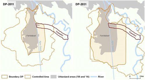
In order to facilitate urban development in the different sectors of the DP-2011, the Haryana Urban Development Authority (HUDA) – backed by India’s Land Acquisition Act from 1894 and (claiming) public interest – acquired former agricultural land from farmers, consolidated the land in larger plots, and then sold the plots to large private developers to realize mainly residential projects (JNNURM, Citation2006).
3. Methods
A map is a powerful and well-known medium to present urban structures and inform urban policy. While mapping is considered as a process (Perkins, Citation2010), mapping the processes of urbanization is a challenging exercise. Engaging with the ‘epistemological and ontological problem’, stressed by CitationHarvey (Citation1996), of whether to focus on the ‘“thing” we call a “city”’ or the process of urbanization, we created the Main Map with the aim to visualize current spatially fragmented and socially uneven processes of rapid urbanization in peri-urban Faridabad. This section elaborates our methodological approach of mapping these highly fluid and contested spaces.
Multi-temporal, high-resolution satellite images, and geo-information systems have revolutionized cartographic opportunities (Longley, Citation2002; Pfeffer et al., Citation2015) allowing peri-urban land-use changes to be detected over shorter intervals and with higher accuracy. However, it is widely acknowledged that a sole detection of land-use or land-cover changes cannot explain the reasons for change or certain development trajectories (Lambin et al., Citation2001; Rashed & Jürgens, Citation2010). It can rather be the starting point for a better understanding of the processes, generating awareness and posing new questions to be answered with using social science research on the ground. To create and interpret a map of (peri-)urbanization processes in Faridabad, we, therefore, chose to apply a mixed-method approach of remote sensing to identify and map land-use changes and explain them based on qualitative interviews and secondary data.
3.1. Multi-temporal, contextual mapping using a transect approach
Due to the highly heterogeneous landscapes of peri-urban areas, we decided against (semi-)automated classification algorithms for the identification of land uses. Instead, we followed an approach of visual image interpretation and manual mapping, which ‘offers an efficient method to classify complex and heterogeneous landscapes’, such as peri-urban areas (Antrop & Van Eetvelde, Citation2000, p. 56). Even with the available advanced remote sensing technology (Baud, Kuffer, Pfeffer, Sliuzas, & Karuppannan, Citation2010; Pfeffer et al., Citation2015), ‘[v]isual interpretation is better suited for delimiting patches that incorporate built and non-built components of the landscape, compared to digital image processing approaches’ (Zhou, Cadenasso, Schwarz, & Pickett, Citation2014, p. 3370). Therefore, we used multi-temporal Google Earth imagery (chosen scenes dated 26 February 2008 and 9 September 2016) and the visual interpretation was guided by reference data (GPS-based field mapping of the different land uses and photos as ground truth data) from a field survey in October 2016.
As fieldwork resources were limited, an 18-km-long transect stretching across representative stages of the expansion of Faridabad was defined for visual image interpretation and manual mapping as well as for the collection of qualitative data. Transect approaches – most commonly used for the analysis of ecosystems and vegetation analysis (Forman, Citation2014) – follow a gradient paradigm, which is based on the assumption that ‘environmental variation is ordered in space’ (McDonnell & Pickett, Citation1990). Based on the understanding that peri-urban areas show ordered spatial variation, several studies use transect approaches to identify the spatial orders and trends of (peri-)urbanization in a practicable manner (Gianotti, Getson, Hutyra, & Kittredge, Citation2016; Schlesinger, Citation2013; Zhu, Zhang, Li, & Zhu, Citation2014). In the case of Faridabad, the land-use regulations of the two DPs and the Controlled Area clearly define a spatial order. We have chosen a transect following a main road (called Kheri Road) which encompasses different land-use regulations, including different sectors of the DP-2011 and DP-2031 as well as the surrounding Controlled Area. The transect stretches from densely built-up urban areas of Faridabad to the rural fringe ending at the river Yamuna. To trace back the development of the transect so far, we considered two dates in the mapping process: the situation in 2008 is set as the reference base for the development, as it marked the beginning of major land-use changes according to the analysis of Landsat-5 satellite imagery. The second date is September 2016, thus depicting what we call today’s spatial reality.
Summarizing the mapping approach, we argue that by incorporating field data (GPS, photos, interviews) to support the visual interpretation and manual mapping, whilst focusing on a representative transect, our approach enables a fast, but reliable, multi-temporal, contextual mapping. This mapping goes far beyond the quantification of land uses and provides the foundation to analyze the underlying processes and drivers of peri-urban development.
For further interpretation of the spatio-temporal data, we conducted 15 extensive, semi-structured interviews with key actors involved in the development process (including landowners, investors, farmers, and planners, who were selected in close collaboration with local resource persons based on the criteria to include representatives of all relevant stakeholders) and analyzed secondary data (socio-economic data, urban development plans). These informations were used to develop the contextual land-use categories. By triangulating our findings from mappings with qualitative data collection, our approach enables us to quickly generate contextual land-use classification and detect land-use changes (see ). This is necessary to follow current and future peri-urban developments in Faridabad and give up-to-date policy recommendations for sustainable and inclusive peri-development in India and beyond (see CitationDannenberg, Follmann, & Hartmann, 2017).
Table 1. Categories for the contextual land-use classification.
Our approach addresses three main points: first, the major contextual land-use categories are mapped for 2008 and 2016. Second, the comparison of the land uses for 2008 and 2016 highlights major urban development pathways in peri-urban Faridabad. Third, by providing the zoning regulations of the DP-2011 and DP-2031, the Main Map provides a juxtaposition of the planned land uses with the actually developing land uses, which allows quick comparison and the identification of non-conformities between the multi-temporal spatial realities and the planned vision.
3.2. Mapping of contextual land-use categories
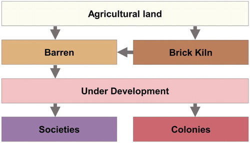
Our contextual land-use classification resulted in the identification of seven major land-use categories (villages, societies, colonies, under development, barren land, brick kilns, and agriculture) for the chosen transect. These mapped categories are described in and jointly constitute the main narratives of Faridabad’s rapidly transforming peri-urban areas.
3.3. Plan vs. reality: comparing land-use changes with zoning regulations
In order to show the dynamic land-use changes along the transect in the period 2008–2016, we present the 2008 and 2016 contextual land-use classification for easy comparison next to each other rather than producing an overlay map. This allows general patterns of land-use change to be studied indicating that agricultural land loss has been immense, in particular in the western part. Additionally, it allows us to compare the different land uses with the different zoning regulations. Therefore and in order to identify planned and unplanned, formal and informal developments, we reproduced the land-use regulations of the DP-2011 and DP-2031 (GoH-DTCP, Citation1991a, Citation2014a). The comparison of the zoning regulations of the DPs with the actual land uses indicates several non-conformities with the DP-2011 and even more conflicting land uses in the Controlled Area and the drafted zoning of the DP-2031. Non-conformities of land uses are especially present in the central part of the transect, where land has been developed despite agricultural zoning and scattered developments are proliferating. This means, that even though the DP-2031 is not yet approved, a conversion of land uses has already taken place.
Here, our contextual approach helps to visualize the spatio-temporal juxtaposition of two development pathways: the planned and the unplanned development pathway. As the development of residential uses dominates in the transect, we outline the development pathways for these in an exemplary way. While the final stage of the planned development pathway is the completion of a society, the final stage of the unplanned development pathway is marked by the existence of a colony. Based on satellite imagery and even in the field, the gradual land-use change from agriculture to societies or colonies (as indicated by and explained in more detail in ), appears visually almost identical. A society or a colony under development often looks very similar. Using remote sensing, we are only able to distinguish colonies and societies in a later stage of development, when single plots are demarcated or large-scale buildings are constructed. However, based on our contextual knowledge from qualitative fieldwork, which has detected the invisible governance structures, the two development pathways can be identified. It is important to note here that the depiction of the pathways as planned vs. unplanned is based on the interpretation of conducted interviews and fieldwork data; whether a certain development is legal or illegal needs to be analyzed by individual case. The two pathways need to be understood as dominant spatio-temporal narratives of urban development, which help us to evaluate ongoing and foresee future developments. The Main Map produced will guide our future research exploring the different governance structures of the two development pathways, which we aim to outline in detail elsewhere.
Figure 2. Typical land-use changes of the development pathways. Source: Authors.
4. Conclusions
The Main Map documents Faridabad’s peri-urban transformation and compares the ongoing development process with the planned vision for the city. It indicates that besides the projected extension (developmental area of DP-2011) of the city of Faridabad, adjacent areas (Controlled Area) have experienced scattered urban development and rapid agricultural land loss. Overall, peri-urban Faridabad is characterized by a massive transformation of land uses from rural to urban. Concurrently, the map indicates that this transformation does not follow a consistent narrative. We extracted two major development pathways, which differ in terms of their governance structures and produce different spatial realities. Up to now, these two pathways have co-existed spatially segregated: the planned development pathway dominates in the developmental area of the DP-2011, the unplanned development pathway is the dominant narrative for the Controlled Area. With the drafted expansion of developmental area (DP-2031), the complex spatial realities of Faridabad’s unplanned peri-urban areas will collide with the envisioned ‘planned city’. This idiom of (peri-)urban planning is documented for other case studies in India and beyond (CitationFollmann, 2016; Kennedy & Sood, Citation2016; Rumbach, Citation2017; Shatkin, Citation2016), where urban development plans have failed to provide a framework of inclusive development and resulted in wide lacunae ‘between the de jure and de facto development’ (Pethe, Nallathiga, Gandhi, & Tandel, Citation2014).
Within the complex configuration of a peri-urban area, our mixed-method transect approach producing contextual land-use classification generates spatial knowledge far beyond the sole examination of land use. Rather the produced map visualizes the heterogeneous spatio-temporal forms of planned and unplanned developments in and around Faridabad and allows urbanization as a process to be reviewed (Harvey, Citation1996) by comparing planned land uses with the actually developing land uses, rather than ex-post analyzing the hybrid planned/unplanned city. Henceforth, this map will be updated by further periods of fieldwork as well as additional data sets and, thus, supports subsequent field research to examine Faridabad’s ambiguous development in more detail.
Software
Data processing and map design were performed with open-source GIS QGIS 2.18.2 (QGIS Development Team, Citation2017).
JoM_Map_reviewed.pdf
Download PDF (1.6 MB)Acknowledgements
The authors would like to thank the participants of the field school ‘Natural and Cultural Heritage as New Commons’ under the DAAD-funded Thematic Network ‘Remapping the Global South - Teaching, Researching, Exchanging’. The field school was hosted at the Jawaharlal Nehru University (JNU) and was jointly organized by Suresh Babu, Milap Punia (both JNU), Peter Dannenberg, and Alexander Follmann. Sincere thanks go to the Global South Studies Center Cologne and the coordinator of the DAAD Thematic Network Ulrike Wesch.
Disclosure statement
No potential conflict of interest was reported by the authors.
Additional information
Funding
Related Research Data
References
- Allen, A. (2014). Peri-urbanization and the political ecology of differential sustainability. In S. Parnell & S. Oldfield (Eds.), The Routledge handbook on cities of the global south (pp. 522–538). New York: Routledge.
- Antrop, M., & Van Eetvelde, V. (2000). Holistic aspects of suburban landscapes: Visual image interpretation and landscape metrics. Landscape and Urban Planning, 50(1), 43–58. doi: 10.1016/S0169-2046(00)00079-7
- Baud, I., Kuffer, M., Pfeffer, K., Sliuzas, R., & Karuppannan, S. (2010). Understanding heterogeneity in metropolitan India: The added value of remote sensing data for analyzing sub-standard residential areas. International Journal of Applied Earth Observation and Geoinformation, 12(5), 359–374. doi: 10.1016/j.jag.2010.04.008
- Bhan, G. (2013). Planned illegalities. Economic and Political Weekly, XLVIII(24), 58–70.
- Dannenberg, P., Follmann, A., & Hartmann, G. (2017). Urbanisierung und peri-urbaner Wandel in und um Faridabad, Indien. In A. Follmann, D. Hölzel, J. Poerting, & M. Schmitt (Eds.), Aktuelle Forschungsbeiträge zu Südasien. 7. Jahrestagung des AK Südasien, 27./28. Januar 2017, Augsburg (Geographien Südasiens, Band 8) (pp. 33–36). Berlin: CrossAsia-eBooks.
- Dikshit, J. K. (Ed.). (2011). The urban fringe of Indian cities. Jaipur: Rawat Publications.
- Dupont, V. (2005). Residential practices, creation and use of space: Unauthorized colonies in Delhi. In E. Hust & M. Mann (Eds.), Urbanization and governance in India (pp. 311–342). New Delhi: Manohar.
- Follmann, A. (2015). Urban mega-projects for a ‘world-class’ riverfront – The interplay of informality, flexibility and exceptionality along the Yamuna in Delhi, India. Habitat International, 45(Part 3), 213–222. doi: 10.1016/j.habitatint.2014.02.007
- Follmann, A. (2016). Governing riverscapes. Urban environmental change along the river Yamuna in Delhi, India. Stuttgart: Steiner.
- Forman, R. T. T. (2014). Urban ecology – Science of cities. Cambridge: Cambridge University Press.
- Gianotti, A. G. S., Getson, J. M., Hutyra, L. R., & Kittredge, D. B. (2016). Defining urban, suburban, and rural: A method to link perceptual definitions with geospatial measures of urbanization in central and eastern Massachusetts. Urban Ecosystems, 19(2), 823–833. doi: 10.1007/s11252-016-0535-3
- GoH-DTCP. (1991a). Development plan 2011 A.D. Map. Retrieved from https://tcpharyana.gov.in/Development_Plan/Faridabad/Faridabad/FDP_2011/FDP_2011_FBC_Map.pdf
- GoH-DTCP. (1991b). Development plan 2011 A.D. Notification, 13/29/9I-3CII. Retrieved from https://tcpharyana.gov.in/Development_Plan/Faridabad/Faridabad/FDP_2011/FBC_2011_Exp_Note.pdf
- GoH-DTCP. (2014a). Draft development plan 2031 A.D. Map. Retrieved from https://tcpharyana.gov.in/Development_Plan/Faridabad/Faridabad/DDP_2031/DDP_2031_FBC_Exp_Note.pdf
- GoH-DTCP. (2014b). Draft development Plan 2031 A.D. Notification, 14th July, 2014. No. CCP(NCR)/FBC(DDP-31)/2014/1312. Retrieved from https://tcpharyana.gov.in/Development_Plan/Faridabad/Faridabad/DDP_2031/DDP_2031_FBC_Exp_Note.pdf
- Harvey, D. (1996). Cities or urbanization? City, 1(1–2), 38–61. doi: 10.1080/13604819608900022
- Jain, M., & Pallagst, K. (2015). Land use beyond control. disP – The Planning Review, 51(3), 29–43. doi: 10.1080/02513625.2015.1093349
- JNNURM. (2006). Faridabad – City development plan 2006–2012. Faridabad.
- Kennedy, L., & Sood, A. (2016). Greenfield development as tabula rasa. Economic and Political Weekly, 51(17), 41–49.
- Lambin, E. F., Turner, B. L., Geist, H. J., Agbola, S. B., Angelsen, A., Bruce, J. W., … Xu, J. (2001). The causes of land-use and land-cover change: Moving beyond the myths. Global Environmental Change, 11(4), 261–269. doi: 10.1016/S0959-3780(01)00007-3
- Longley, P. A. (2002). Geographical information systems: Will developments in urban remote sensing and GIS lead to ‘better’ urban geography? Progress in Human Geography, 26(2), 231–239. doi: 10.1191/0309132502ph366pr
- McDonnell, M. J., & Pickett, S. T. (1990). Ecosystem structure and function along urban-rural gradients: An unexploited opportunity for ecology. Ecology, 71(4), 1232–1237. doi: 10.2307/1938259
- Perkins, C. (2010). Mapping and graphicacy. In N. J. Clifford, S. French, & G. Valentine (Eds.), Key methods in geography (pp. 350–373). London: Sage.
- Pethe, A., Nallathiga, R., Gandhi, S., & Tandel, V. (2014). Re-thinking urban planning in India: Learning from the wedge between the de jure and de facto development in Mumbai. Cities (London, England), 39, 120–132.
- Pfeffer, K., Martinez, J., O’Sullivan, D., & Scott, D. (2015). Geo-technologies for spatial knowledge: Challenges for inclusive and sustainable urban development. In J. Gupta, K. Pfeffer, H. Verrest, & M. Ros-Tonen (Eds.), Geographies of urban governance: Advanced theories, methods and practices (pp. 147–173). Cham: Springer.
- The Punjab Scheduled Roads and Controlled Areas Restriction of Unregulated Development Act, 1963. (1963).
- QGIS Development Team. (2017). QGIS geographic information system: Open source geospatial foundation project. Retrieved from http://www.qgis.org/
- Rao, U. (2013). Tolerated encroachment: Resettlement policies and the negotiation of the licit/illicit divide in an Indian metropolis. Cultural Anthropology, 28(4), 760–779. doi: 10.1111/cuan.12036
- Rashed, T., & Jürgens, C. (Eds.). (2010). Remote sensing of urban and suburban areas. Dordrecht: Springer.
- Ros-Tonen, M., Pouw, N., & Bavinck, M. (2015). Governing beyond cities: The urban-rural interface. In J. Gupta, K. Pfeffer, H. Verrest, & M. Ros-Tonen (Eds.), Geographies of urban governance: Advanced theories, methods and practices (pp. 85–105). Cham: Springer.
- Roy, A. (2009). Why India cannot plan its cities: Informality, insurgence and the idiom of urbanization. Planning Theory, 8(1), 76–87. doi: 10.1177/1473095208099299
- Rumbach, A. (2017). At the roots of urban disasters: Planning and uneven geographies of risk in Kolkata, India. Journal of Urban Affairs, 39(6), 783–799. doi: 10.1080/07352166.2017.1282771
- Schlesinger, J. (2013). Agriculture along the urban-rural continuum: A GIS-based analysis of spatio-temporal dynamics in two medium-sized African cities (Dissertation). Albert-Ludwigs-Universität, Freiburg.
- Shatkin, G. (2016). The real estate turn in policy and planning: Land monetization and the political economy of peri-urbanization in Asia. Cities (London, England), 53, 141–149. doi: 10.1016/j.cities.2015.11.015
- Sridharan, N. (2011). Spatial inequality and the politics of urban expansion. Environment and Urbanization Asia, 2(2), 187–204. doi: 10.1177/097542531100200204
- Tiwari, P. (Ed.). (2016). The towers of New capital: Mega townships in India. London: Palgrave Macmillan.
- Zhang, Y. (2017). The credibility of slums: Informal housing and urban governance in India. Land Use Policy. doi: 10.1016/j.landusepol.2017.05.029
- Zhou, W., Cadenasso, M. L., Schwarz, K., & Pickett, S. T. A. (2014). Quantifying spatial heterogeneity in urban landscapes: Integrating visual interpretation and object-based classification. Remote Sensing, 6(4), 3369–3386. doi: 10.3390/rs6043369
- Zhu, F., Zhang, F., Li, C., & Zhu, T. (2014). Functional transition of the rural settlement: Analysis of land-use differentiation in a transect of Beijing, China. Habitat International, 41, 262–271. doi: 10.1016/j.habitatint.2013.07.011
- Zimmer, A. (2012). Enumerating the semi-visible: The politics of regularising Delhi’s unauthorised colonies. Economic and Political Weekly, 47(30), 89–97.