
ABSTRACT
This paper describes a collaboration between a visual artist and geoscientists, who together viewed the same rugged, high mountain landscape through different, yet complementary, lenses. We pair scientific mapping and historic comparative photography with a series of site-specific sculptural installations to interpret the dramatic geological changes that occurred at Kaskawulsh Glacier, Yukon, in the spring of 2016. In the summer of that year, artist K.A. Colorado accompanied geoscientists D.H. Shugar, J.J. Clague, and J.L. Best to the terminus of Kaskawulsh Glacier, as well as Kluane Lake downstream of the glacier, to document the landscape changes that occurred earlier in the year. The Boundary images were created as on-site, three-dimensional, artistic interpretations of the markedly changed boundaries that occurred as a result of climate-induced glacier retreat and the sudden subcontinental-scale reorganization of drainage. Both the scientific study conducted by the geomorphologists and the art installations created by the artist were performed simultaneously. The Boundary installation art project, together with satellite imagery and historical photographs, conveys the death of Slims River as a result of climate change.
1. Introduction
Landscapes undergo change over a wide range of temporal and spatial scales and in response to many autogenic and allogenic drivers. Such change can be slow and imperceptible but also, when a threshold or tipping point is reached, can be sudden and catastrophic. Slow hillside creep and catastrophic landslides are examples of such scale changes acting on one geomorphic element. Climate change also ushers in new conditions and environmental change, and anthropogenically induced change is currently reshaping processes and landscape response in many parts of the world. Such changes also frequently yield boundaries between new and old, between changed and static, and between one geomorphic state and another. In this paper, we describe one such sudden change – to a river drainage network – that is the product of climate change within the industrial era. Although the scientific publication arising from our work (CitationShugar et al., 2017) reached a wide audience through press coverage in print (e.g. CitationDevlin, 2017; CitationSchwartz, 2017), radio (e.g. CitationBBC World Service, 2017; CitationCBC The Current, 2017), and online (e.g. CitationFrostenson, 2017; CitationKingdon, 2017; CitationStruzik, 2017), art can provide another medium by which to portray such change and reach people in different ways. Here, we marry maps and photographs used to explain the science of such landscape change with new and different portrayals of boundaries within the changed landscape revealed by art. We seek to support a view that art can lie at the center of an ‘eARTh science’ representation, here illustrated by collaboration between geomorphologists and an artist and their observations of rapid landscape change viewed through two different lenses.
2. Late Holocene evolution of Kaskawulsh Glacier
Our physical science team approached the phenomenon of boundary change at Kaskawulsh Glacier using a series of new and historical maps of the glacier terminus and its associated glacial lakes. Kaskawulsh Glacier is one of the largest valley glaciers flowing eastward from the St. Elias Mountains (), and scientists have shown that this glacier achieved its maximum Little Ice Age (LIA) extent between ∼AD 1717 and the 1750s (CitationBorns & Goldthwait, 1966; CitationDenton & Stuiver, 1966; CitationReyes, Luckman, Smith, Clague, & Van Dorp, 2006). During this LIA ice advance, a sediment fan was built by meltwater flowing from the nearby terminus of Kaskawulsh Glacier, raising the level of a river that formerly drained south from Kluane Lake. At the LIA maximum, the glacier extended across the valley occupied by the Slims and Kaskawulsh rivers, and its terminus split into two lobes around a prominent bedrock hill (). Some of the meltwater from the glacier discharged north via Slims River into Kluane Lake, and eventually into the Bering Sea, while the remainder discharged via Kaskawulsh River into Alsek River and from there to the North Pacific Ocean. Kaskawulsh Glacier thus fed water across a drainage divide and a border between two river catchments that discharged into different oceans. Ice retreat did not begin until the late nineteenth century, and by 1972 (the first Landsat satellite scene), the eastern and western lobes had retreated ∼1.5 and 1.9 km, respectively, from the LIA terminal moraine. Between 1972 and 2016, the glacier retreated a further 0.1–1.1 km. The width-averaged retreat of Kaskawulsh Glacier between 1899 and 2016 was 1.9 km (CitationShugar et al., 2017).
Figure 1. Location map of study area in southwest Yukon. Numbered dots refer to locations of historic photos () and Boundary installation photos ().
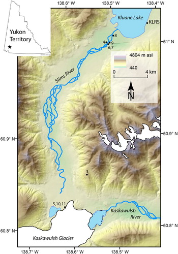
Figure 2. Maps showing changes in the terminus of Kaskawulsh Glacier since the LIA and lake growth since 1972. (A) Contour map (interval 100 m) overlain by dashed lines indicating the glacier terminus positions in ∼1717, 1972, and 2016, with gray polygons indicating the extent of proglacial lakes in 1972, 2000, and 2016. (B) The same terminus positions and lake extents as in (A), except with a 2-m satellite-derived DEM as a background. Note that contour lines in (A) were produced from the same DEM as shown in (B), but with 100 m intervals. The 2-m DEM was derived from along-track stereo WorldView-1 imagery (29 November 2012) provided by the DigitalGlobe Foundation, and constructed using the SETSM algorithm (CitationNoh & Howat, 2015). Outlines of the Slims and Kaskawulsh rivers were digitized from a SPOT5 satellite image from 18 June 2016. The camera icon in (B) shows the approximate location and orientation of the photo stations used to acquire the images in .
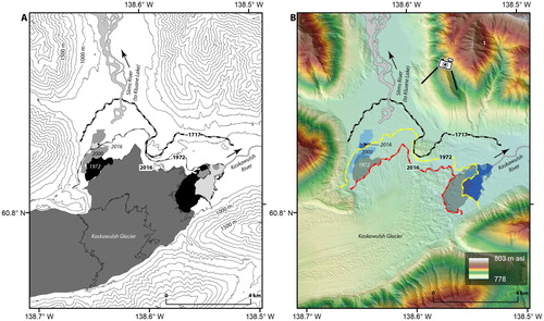
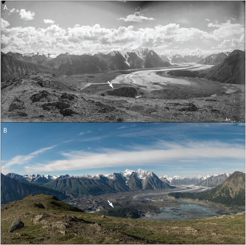
Figure 3. Historic and modern photographs of Kaskawulsh Glacier terminus. (A) Photo panorama taken by Dominion Land Surveyor James Joseph McArthur in 1900. (B) Photo panorama taken at the same location as (A) by the Mountain Legacy Project (http://explore.mountainlegacy.ca/) in 2012. Both panoramas comprise multiple high-resolution photographs. Note the presence of the bedrock hill described in the text, annotated with white arrows. The historic image is archived in the Library and Archives Canada/Bibliothèque et Archives Canada (http://www.bac-lac.gc.ca/eng/Pages/home.aspx). The images are used under a Creative Commons Attribution-NonCommercial 4.0 International License. A slider comparison is available at http://tinyurl.com/ya2nzlky
As Kaskawulsh Glacier retreated, proglacial lakes formed at its terminus and fed large braided rivers. The lakes – ‘Slims Lake’ on the west side of the glacier terminus and ‘Kaskawulsh Lake’ on the east – expanded dramatically toward the end of the twentieth century (, Main Map). In the spring of 2016, Slims Lake suddenly drained into Kaskawulsh Lake, thereby beheading Slims River (CitationShugar et al., 2017). This ‘river piracy’ event marked a major, and probably permanent, reorganization of the drainage system. Virtually, all meltwater flowing from Kaskawulsh Glacier now discharges into Kaskawulsh River, while Slims River discharge into Kluane Lake is greatly reduced, resulting in a lowering of the level of the lake.
3. Mapping changes at the Kaskawulsh Glacier terminus
Here, we illustrate this remarkable story using two maps (), a pair of historic and modern comparative photographs (), and a series of photographs depicting the artist Colorado's Boundary art installation (). The first map ((A)) shows the retreat of Kaskawulsh Glacier and formation of the two lakes at its terminus as it would have been depicted in the mid-1900s, prior to the geospatial revolution in high-resolution mapping. At that time, glacier margins would have been traced visually on aerial photographs and transferred by pen to a paper map. The second map ((B)) shows the same story, but uses satellite imagery and modern GIS software. The positions of the glacier terminus and lake extents were digitized manually in ArcGIS. (B) is underpinned by a hillshaded digital elevation model (DEM) created from ultra-high-resolution satellite images. The 2-m-resolution DEM derived from along-track stereo WorldView-1 imagery from 29 November 2012 and was constructed using the SETSM algorithm (CitationNoh & Howat, 2015).
Figure 4. ‘Goodbye Slims’ – Slims River valley view. This art installation leads the viewer's eyes to the former channel of Slims River, which was abandoned due to retreat of Kaskawulsh Glacier. Art image © 2016 K.A. Colorado.
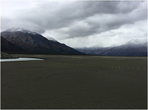
Figure 5. ‘Yukon Flux’ – view up Slims River valley to Kaskawulsh Glacier. The fluorescent balls contrast with the dark surface, emphasizing the instability of the ice that lies below. Art image © 2016 K.A. Colorado.
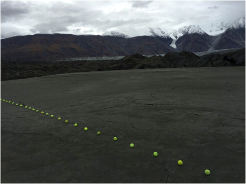
Figure 6. ‘Metaphor’ – Slims River reduction. This art installation accentuates the lines of the dried Slims River bed. Art image © 2016 K.A. Colorado.
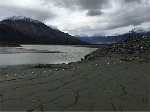
Figure 7. ‘Termination/subordination’ – Slims River bank. This art installation points toward the former Slims River edge. Art image © 2016 K.A. Colorado.
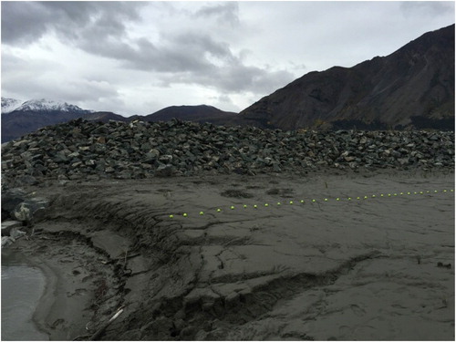
Figure 8. ‘Horizon Drain’ – the edge of Slims River looking toward Kluane Lake. The line of balls sits on the bed of the former river and contrasts with the horizon in the distance. Art image © 2016 K.A. Colorado.
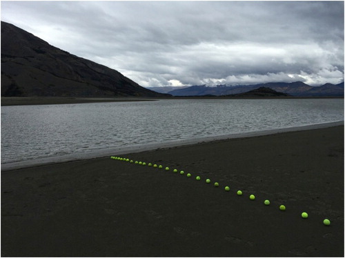
Figure 9. ‘Bridge Flow’ – line along the reduced Slims River at Kluane Lake. The art installation's metaphoric boundary line symbolically delineates the border of the vanished river. Art image © 2016 K.A. Colorado.
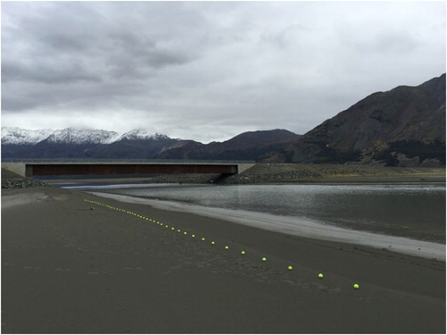
Figure 10. ‘Dominion’ – boundary line to the glacier. The art installation is positioned in an area of sediment covering the dead toe of Kaskawulsh Glacier. Light from the sky reflects from the remnant of Slims Lake, creating a silhouette of the mountain range. Art image © 2016 K.A. Colorado.
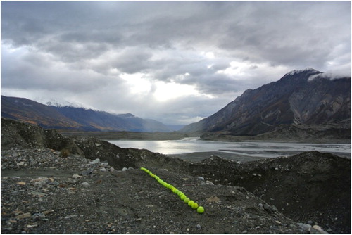
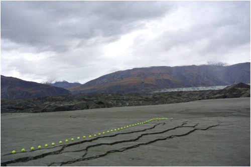
Figure 11. ‘Surface Breach’ – bordering the glacier. This art installation parallels the mud cracks along the floor of Slims valley, beneath which lies dead glacier ice. Art image © 2016 K.A. Colorado.
The piracy of the waters of Slims River in the spring of 2016 was a direct consequence of the elevation and gradient differences between the two rivers (e.g. see in CitationShugar et al., 2017). From both geomorphic and artistic perspectives, the toe of the glacier formed a physical boundary between the Slims and Kaskawulsh watersheds. This boundary disappeared abruptly when Slims Lake drained in a geological instant into Kaskawulsh Lake and from there into Alsek River downvalley.
Historic photographs have been used with great success to map centennial- and decadal-scale glacier change (e.g. CitationButler & DeChano, 2001; CitationByers, 2007), and we illustrate this approach by showcasing a historic photograph of the Kaskawulsh Glacier terminus taken in 1900 with one from the same vantage point in 2012 (). The loss of ice over this period is remarkable, as is the modern development of a large proglacial lake (Slims Lake) at the head of Slims River.
4. Roots of the Boundary art project
Colorado's project of setting up sculptural elements comprising brightly colored tennis balls originated over two decades ago as an artistic form of environmental and geographical visual referencing (CitationColorado, 2006, Citation2010; CitationDNA, 2012). The Boundary art project is the latest in a series of ongoing art-science interdisciplinary projects that began in 2003 in Ushuaia, Argentina. This art was centered on glacier and iceberg representations, which culminated in visual artistic images and a series of three-dimensional sculptural works, and enabled the first contacts between Colorado and Clague.
The concept for tennis ball installed sculptures was born in 1992 during Colorado's morning walks with his dog. The artist envisioned placing these human-fabricated elements on a large-scale natural landscape to delineate geological features and changing conditions, and to comment on the reality of terrain that is being altered by human-induced climate change. These brightly colored tennis balls allowed establishment of fabricated geometric shapes in a line across a large natural landscape affected by climate change and forming a boundary to guide the eye in altered physical environments.
5. Description of the Boundary art project
The Boundary art project was conceived as a series of photographically documented 3D installations featuring human-made elements purposely placed on land and former water bodies to convey scale, depth of field, landscape detail, and the presence or absence of geomorphological and geological features. Rows of tennis balls are used to juxtapose human-made objects against natural landscapes. The design was modular, enabling the artist to position each separate object in a formation that, in total, created a holistic visual experience. In applying this concept to the Kaskawulsh Glacier site, these Boundaries metaphorically trace land and water features that have been altered in a changing climate, and specifically herein the Slims River and now-exposed delta plain at Kluane Lake. The images reproduced in the present paper are related in that they have a common visual thread – a row of tennis balls positioned on the ground. Taken together, they represent the overall geographic area affected by glacial retreat.
To complement and expand the scientific mapping and photography of the landscape, Colorado approached the geomorphic phenomenon of boundary change at Kaskawulsh Glacier using an artistic, interpretive, and intuitive method. Rather than being a literal scientific measurement or evaluation, the Boundary installations metaphorically referenced the changes being effected by retreat of the glacier. By placing art installations on the dry terrain that had once been water bodies and rubble-covered dead ice of Kaskawulsh Glacier, this art aimed to create a large-scale visual reference to the boundary of the disappeared river and lake, and a three-dimensional border pointing to the receding glacier. In this way, this art sought to raise an emotional awareness of change, specifically the vanishing geomorphological features and water bodies, and thereby highlight the tangible – as well as the unseen – results of climate change on the landscape.
The Boundary art is represented in this paper by eight images () showing lines of fluorescent tennis balls on dark, dry, flat surfaces, visually demarcating the former channel of Slims River that was abandoned due to the retreat of Kaskawulsh Glacier. The glacier can be seen in the background of some of the installations (, , and ). The sculpturally composed ’border’ line provides a visual reference to the size of the altered area and the changes in the boundaries of the Slims and Kaskawulsh watersheds. The linear arrangement of the balls was intended to provide a visual reference to elevation, detail, and contrast of landscape features. The fluorescent yellow-green color of each ball arranged in sequence was an artistic device intended to amplify the surrounding earth features observed and quantified in our geomorphological study.
Because the artist was integrated with the group of scientists, and yet able to maintain independence in terms of geographic location and set-up, the Boundary art successfully incorporated the geoscientific findings, using the open stretches of dry land and glacier ice as a platform and canvas.
The installation of the sculptural elements was conducted in an environmentally sensitive, non-invasive manner. Rather than altering or permanently marking landforms at the sites by installing imposing structures on the landscape, the Boundary art employed tennis ball placements that were temporary and removable.
The sculpture pieces were installed by the artist at the same time the scientists were documenting the landscape, and depict artistically geomorphological change reported in the scientific literature the following year (CitationShugar et al., 2017). We awaited publication of the scientific study before releasing the artwork depicting the same event, and the current article is the first publication of images taken of the installations; it is intended to convey this significant event to a larger, non-scientific, public audience.
6. Environmental art and the connection with science
Early European and American artists captured atmospheric phenomena and geologic events that altered the visual representation in their art. For example, nineteenth century Norwegian painter Edvard Munch, in his famous masterpiece The Scream (https://www.edvardmunch.org/the-scream.jsp), depicted a reddened sky that, according to astrophysicist Donald Olson, reflected the atmospheric conditions caused by the eruption of Mount Krakatoa in 1883 (CitationDrapkin & Zielinski, 2009). The painting was not just a creative interpretation, but also a visualization of what the artist thought about climate as it related to a geologic event. In studies by CitationZerefos et al. (2014), aerosol optical depths following major volcanic eruptions were estimated by examining sunset skies as painted by artists around the world over a 500-year period, including works by Edgar Degas, Joseph Turner, Joshua Reynolds, Thomas Gainsborough, and John Constable. CitationWood (2014) also highlights the influence of volcanic eruptions on depictions of skies in landscape paintings, such as those by Constable, as well as the influence of weather conditions such as the ‘volcanic’ summer thunderstorm on 18 June 1816, on writers such as Mary Shelley who created Frankenstein. CitationBoudreau (2012) contends that Constable painted his skies with a scientific method, with his range of cloud studies attempting to encapsulate a broad and representative sample of the population under consideration.
One artist whose work had a strong impact on Colorado is Frederic Church, the nineteenth century American landscape painter who helped establish the Hudson River School and who was influenced by scientist Alexander von Humboldt. Church's oil paintings included representations of the Andes and of icebergs (https://collections.dma.org/artwork/4171219) in the north (CitationWilton & Barringer, 2002), which also influenced Colorado's portrayal of deep cold and icebergs (CitationColorado, 2010).
The Land Art movement of the 1960s and 1970s saw artists constructing forms that emphasized the curve and flatness of the landscape, but they did not speak specifically to climate change. Notably, the Spiral Jetty of Robert Smithson (https://www.robertsmithson.com/earthworks/spiral_jetty.htm), a pioneer in Land Art, with its spiral of rocks laid out on a flat plane in Great Salt Lake, Utah, was a major seminal piece that emerged from Minimalism and Conceptualism (CitationGuggenheim, n.d.). Although not climate-related, this artwork referenced the unique value of absolute flatness and made a definitive artistic statement about color, form, movement, and memory. Andy Goldsworthy creates his own spirals using natural materials such as ice, snow, mud, branches, and flowers to make patterns on landscapes as purely empathetic expression (CitationFunderburg, 2015). Goldsworthy relies heavily on architecture as a contrast, bringing an intersection of landscape and architectural structures to his art. Nancy Holt constructs steel and concrete sculptures in the outdoors. Her monumental works, such as Sun Tunnels (https://umfa.utah.edu/land-art/sun-tunnels), define and frame the sun, and portray ecological messages (CitationKennedy, 2014). These works brought the gallery to the Earth, rather than the Earth to the gallery. In recent decades, Christo has used replicated images, repeated in sequence, to define the landscape, referencing land mass and geographic features, and making the viewer look at the landscape differently (CitationThe Art Story, n.d.).
Contemporary artists, including painters, illustrators, and sculptors whose work deals with the environment, attempt to capture environmental realities as well as objectified visions of reality. Zaria Forman (http://www.zariaforman.com), an American artist, creates soft pastel chalk drawings that replicate the beauty of icebergs and ocean waters, and focus on their fragility and beauty (CitationKwartler, 2016). Anna McKee (https://annamckee.com/) works with scientists to create semi-abstract interpretations of climate change. For example, she worked recently with the University of Washington IsoLab to create a symbolic interpretation of the West Antarctic Ice Sheet using water from Antarctic ice cores collected in 2009 (CitationPonnekanti, 2016). Jill Pelto (http://www.jillpelto.com/) also uses climate change graphs interpreted as art work, transforming scientific data into water color paintings (CitationFastCompany, 2016). Lorenzo Quinn, an Italian sculptor, brings awareness of rising sea levels through his monumental sculpture installation Support (https://www.lorenzoquinn.com/venice-biennale-venice-2017/), which features hands rising from the Venice canals to either support or devastate architectural structures (CitationAinley, 2017). Finally, Andrea Juan (https://www.youtube.com/watch?v=2wfyJUWT6WE) uses art applications and photography in the Antarctic to metaphorically represent the past and the present conditions of the continent, although not particularly related to climate change (CitationJuan, 2006). The work of Colorado, such as the Boundary work detailed herein, deals specifically with climate change. Colorado also created a series of Ice Core sculptures incorporating scientific data and papers from scientists and Polar professionals beginning in 2008, as well as a series of Ice Core paintings which he began to create in 2003 and which also speak to climate change. This work considers the implications of ice and deep cold to the human condition, while conveying science through visual, sculptural, and graphic depictions. These works all firmly establish the need for art at the very center of eARTh.
7. Summary
In the spring of 2016, Slims River was cut off from its source – a proglacial lake at the snout of Kaskawulsh Glacier. The ultimate cause of this beheading was climate change; the lake was able to drain in a different direction via an ice-walled canyon cut through the much-thinned toe of the glacier. In the summer of 2016, a team of geoscientists and an artist documented these changes based, respectively, on their scientific and fine art perspectives. The visual images created by the artist represent the fast-changing conditions studied by the scientists and landscape changes caused by climate change. The scientists’ goals were to map, quantify, and explain the processes that led to the changes in the landscape; the artist's intent was to bring climate change and its resulting effects to the viewer in a deep visceral way. The tennis ball sculptural installations, captured by photographs in this Boundary artwork, reference the changing features on the landscape.
Art and science can thus reveal the nature of rapidly changing landscapes and provide a sharp focus on the abruptness of change and the ephemeral nature of borders, allowing a deeper appreciation of the fragility of Earth in the face of climate change. Such collaborations open new dialogues between scientists and artists, and highlight the complementary ways of portraying change to a broad range of observers.
Acknowledgements
We thank Sian Williams and Lance Goodwin for providing accommodation and meals at the Kluane Lake Research Station (Arctic Institute of North America field station). Lance Goodwin, Mike Schmidt (Arctic Institute of North America), and Christian Schoof (UBC) provided useful insights and photographs from the spring of 2016, and Nick Roberts, Kristen Kennedy, Heather Rawley, and Panya Lipovsky assisted with fieldwork. Trans North Helicopters flew us to and from the terminus of Kaskawulsh Glacier. The DigitalGlobe Foundation provided high-resolution optical satellite data. We thank the University of North Carolina at Chapel Hill Research Computing group for providing computational resources that have contributed to these research results. We thank Gillen D’Arcy Wood for discussions regarding volcanic eruptions and cloudscapes, Simon Cook and Julian Ruddock for their constructive feedback on the paper, and guest editors Stephen Tooth, Flora Parrott, Heather Viles and Mike Smith for putting together what promises to be an exciting issue of the Journal of Maps.
Disclosure statement
No potential conflict of interest was reported by the authors.
ORCID
D. H. Shugar http://orcid.org/0000-0002-6279-8420
J. J. Clague http://orcid.org/0000-0002-2697-2233
M. J. Willis http://orcid.org/0000-0001-7872-770X
J. L. Best http://orcid.org/0000-0001-5314-6140
Additional information
Funding
References
- Ainley, N. (2017). Giant hands emerge from a Venice canal to raise climate change awareness. Retrieved from https://www.vice.com/en_us/article/bjj7wv/giant-hands-emerge-from-a-venice-canal-to-raise-climate-change-awareness
- The Art Story. (n.d.). Christo: Bulgarian-American sculptor, photographer, and conceptual artist. Retrieved from http://www.theartstory.org/artist-christo.htm
- BBC World Service. (2017). What made Canada’s Slims River disappear? BBC. Retrieved from http://www.bbc.com/news/video_and_audio/headlines/39659612/what-s-made-canada-s-slims-river-disappear
- Borns, H. W., Jr., & Goldthwait, R. P. (1966). Late-Pleistocene fluctuations of Kaskawulsh Glacier, SW Yukon Territory, Canada. American Journal of Science, 264, 600–619.
- Boudreau, B. A. (2012). John Constable’s 1821 and 1822 cloud studies: The artist as a scientist? Weather, 53, 357–362. doi: 10.1002/j.1477-8696.1998.tb06343.x
- Butler, D. R., & DeChano, L. M. (2001). Environmental change in Glacier National Park, Montana: As assessment through repeat photography from fire lookouts. Physical Geography, 22(4), 291–304. doi: 10.1080/02723646.2001.10642744
- Byers, A. (2007). An assessment of contemporary glacier fluctuations in Nepal’s Khumbu Himal using repeat photography. Himalayan Journal of Sciences, 4(6), 21–26. doi: 10.3126/hjs.v4i6.979
- CBC The Current. (2017). How a Yukon River suddenly vanished in 4 days. In A. M. Tremonti (Ed.), CBC The Current. Retrieved from http://www.cbc.ca/radio/thecurrent/the-current-for-april-19-2017-1.4074216/how-a-yukon-river-suddenly-vanished-in-4-days-1.4074268
- Colorado, K. A. (2006). Aesthetic considerations and implications of snow mass and texture changes. The International Conference on the Problems of Hydrometeorological Security: Prediction and adaptation of the society to the extreme climate changes, Moscow, Russia.
- Colorado, K. A. (2010). The cow on the iceberg: The relevancy of deep cold – Communicating climate concerns through art. Monterey, CA: TEDx Monterey.
- Denton, G. H., & Stuiver, M. (1966). Neoglacial chronology, northeastern St. Elias Mountains, Canada. American Journal of Science, 264, 577–599. doi: 10.2475/ajs.264.8.577
- Devlin, H. (2017, April 17). Receding glacier causes immense Canadian river to vanish in four days. The Guardian. Retrieved from https://www.theguardian.com/science/2017/apr/17/receding-glacier-causes-immense-canadian-river-to-vanish-in-four-days-climate-change
- DNA. (2012). K.A. Colorado, ‘Banquet in the Antarctic’. Sur Polar IV, IV Conferencia Y Festival Internacional de Arte y Cultura Antártica (Dirección Nacional del Antártico). Retrieved from https://issuu.com/smproart/docs/catalogo_sur_polar_iv/107
- Drapkin, J., & Zielinski, S. (2009). Forensic astronomer solves fine arts puzzles. Smithsonian Magazine, April.
- FastCompany. (2016). These beautiful paintings turn depressing climate change graphs into art. Retrieved from https://www.fastcompany.com/3056398/these-beautiful-paintings-turn-depressing-climate-change-graphs-into-art
- Frostenson, S. (2017). In 4 days, a river that had flowed for millennia disappeared. Retrieved from https://www.vox.com/science-and-health/2017/4/24/15379046/4-days-river-millennia-disappeared
- Funderburg, L. (2015). Andy Goldsworthy: Natural man. Retrieved from https://www.architecturaldigest.com/gallery/andy-goldsworthy-book-ephemeral-works
- Guggenheim. (n.d.). Collection online: Robert Smithson. Retrieved https://www.guggenheim.org/artwork/artist/robert-smithson
- Juan, A. (2006). Proyecto Antartida = Antarctica project. Programa Antártico Argentino and the John Simon Guggenheim Memorial Foundation.
- Kennedy, R. (2014, February 12). Nancy Holt, outdoor artist, dies at 75. New York Times. Retrieved from https://www.nytimes.com/2014/02/12/arts/design/nancy-holt-outdoor-artist-dies-at-75.html
- Kingdon, A. (2017). Stealing the Slims River. Retrieved from https://www.hakaimagazine.com/news/stealing-slims-river/
- Kwartler, D. (2016). Gallery: Unreal pictures of ice and water. Retrieved from https://ideas.ted.com/gallery-unreal-pictures-of-ice-and-water/
- Noh, M.-J., & Howat, I. M. (2015). Automated stereo-photogrammetric DEM generation at high latitudes: Surface extraction with TIN-based search-space minimization (SETSM) validation and demonstration over glaciated regions. GIScience & Remote Sensing, 52(2), 198–217. doi: 10.1080/15481603.2015.1008621
- Ponnekanti, R. (2016). Artists and geoscientists talk about ice and climate change at next UPS Art-Sci Salon. Retrieved from http://www.thenewstribune.com/entertainment/arts-culture/article55466485.html
- Reyes, A. V., Luckman, B. H., Smith, D. J., Clague, J. J., & Van Dorp, R. D. (2006). Tree-ring dates for the maximum Little Ice Age advance of Kaskawulsh Glacier, St. Elias Mountains, Canada. Arctic, 59(1), 14–20.
- Schwartz, J. (2017, April 17). Climate change reroutes a Yukon River in a geological instant. The New York Times. Retrieved from https://www.nytimes.com/2017/04/17/science/climate-change-glacier-yukon-river.html?_r=0
- Shugar, D. H., Clague, J. J., Best, J. L., Schoof, C., Willis, M. J., Copland, L., & Roe, G. H. (2017). River piracy and drainage basin reorganization led by climate-driven glacier retreat. Nature Geoscience, 10, 370–375. doi: 10.1038/ngeo2932
- Struzik, E. (2017). How warming is profoundly changing a great northern wilderness. Retrieved from https://e360.yale.edu/features/how-warming-is-profoundly-changing-a-great-northern-wilderness
- Wilton, A., & Barringer, T. (2002). American sublime, landscape painting in the United States 1820–1880. Princeton, NJ: Princeton University Press.
- Wood, G. D. (2014). Tambora – The eruption that changed the world. Princeton, NJ: Princeton University Press.
- Zerefos, C. S., Tetsis, P., Kazantzidis, A., Amiridis, V., Zerefos, S. C., Luterbacher, J., … Papayannis, A. (2014). Further evidence of important environmental information content in red-to-green ratios as depicted in paintings by great masters. Atmospheric Chemistry and Physics, 14(6), 2987–3015. doi: 10.5194/acp-14-2987-2014