
ABSTRACT
This paper critically explores a 40-year collaboration between a geomorphologist and a relief printmaker from the perspective of the emerging art-science paradigm in the geosciences. Drawing on the authors’ work and practice worldwide, ‘standard art-science’ (the artist as communicator and observer) and emerging ‘transdisciplinary/paradisciplinary’ practices are explored in the watery realm. While standard art-science ‘encounters’ were viewed favourably from the viewpoint of community engagement, especially by commissioning bodies, they did not measurably improve the explanation of science to the public nor offer new avenues for creative investigation. In light of this, the authors undertook a series of explicitly interdisciplinary/transdisciplinary ‘entanglements’ by co-conceiving projects, carrying out joint fieldwork and ‘data’ collection and, most importantly, working together in the studio and laboratory. These projects suggest that multi-scalar approaches are required when using art-geoscience to explore environmental issues which impact significantly on individuals and communities.
1. Introduction
This paper documents and critically explores a 40-year ‘collaboration’ between a printmaker (Judy Macklin) and a geomorphologist (Mark Macklin) on watery themes from the perspective of the emerging art-science paradigm in the geosciences. It appears to constitute, at least in a UK art-geoscience context, a unique collective autobiography on people-water-art interactions and entanglements over the late twentieth and early twenty-first century. Both are authorities in landscape interpretation and representation, and have since 1980 pursued independent careers working worldwide as an educator and practising artist (Judy) and a university-based geographer studying river systems and environmental change (Mark). Their shared passion for the watery realm was originally fostered by joint fieldwork in their late teenage years that began in the Mediterranean in 1977 as part of their undergraduate studies and has continued ever since with annual sojourns to mainland or island Greece. It has also been manifest since 2005 by their joint participation in competitive long distance sea and river rowing as part of Aberystwyth’s super-vet mixed Celtic Longboat team. This lifetime of collaboration and partnership has provided place-based opportunities to reflect on riverscapes and seascapes that has informed and widened the practice, cultural perspectives and worldviews of the artist and scientist alike. However, for over 30 years these benefits were discipline centred and the notion of developing an interdisciplinary art-science partnership was not explicitly articulated, certainly not within geographical or wider geoscience contexts.
In 2009, a potential step-change in this working relationship was presented by the opportunity to work together on an EU-funded archaeology community engagement project in the Teleorman Valley, Romania (CitationMacklin & Macklin, 2011). For the first time, this required the artist and the scientist to learn and understand each other’s disciplinary languages, working practices, knowledge bases and (pre)conceptions of how art and (geo)sciences are undertaken in studio, laboratory, field, and community settings. It started a reflective and ongoing journey that has increasingly questioned the direction of travel of their own, and other, interdisciplinary art-science interventions.
This paper describes this journey and the process of developing personally meaningful and community relevant art-geoscience interventions, which strive for both (inter-)disciplinary rigour as well as societal benefits such as the better public understanding of some of the most pressing water-related challenges of the twenty-first century. The paper is divided into four sections. In Section 2, the working practice of mapping and mark making, which are fundamental components of geomorphology and relief printmaking, respectively, is briefly outlined. In Section 3, drawing on the authors’ own work and practice as a benchmark, examples of what we term ‘standard art-science’ narratives are discussed. This is where art (and artists) is/are recruited by scientists to improve communication and/or ‘visualisation’ (c.f. CitationLester & Cottle, 2009) of contemporary science that is culturally, socially and politically problematic (CitationLiverman, 2010). These standard art-science narratives are illustrated by reference to multidisciplinary studies on the Romanian Neolithic and engineered riverscapes of the Rhine-Meuse lowlands, which were conceived, led, and funded by the scientific community. In these particular contexts, the primary roles of the ‘embedded’ artist were to act as a communicator in order to help the local community understand, appreciate, and value their archaeology heritage, and also to serve as an ‘adjunct’ observer providing an artistic counterpoint to science-based visualisation and mapping of water flow, channel patterns and hydromorphological dynamics. In Section 4, a series of emerging art-geoscience projects are discussed that follow what we term a ‘transdisciplinary/paradisciplinary’ narrative. The important distinction from ‘standard art-science’ is that these projects were co-conceived by the artist and scientist, who then carried out joint fieldwork, observations and ‘data’ collection and, most importantly, worked together in the studio and laboratory to produce prints, text, and videos, as well as joint presentations and curation of exhibitions. To some degree our ‘standard art-science’ and ‘transdisciplinary/paradisciplinary’ narratives mirror the ‘dialogues’ and ‘doings’ methodological approaches identified by CitationHawkins (2011). Probably because of our multi-decadal ‘entanglement’, however, we would place greater emphasis on the value of co-participatory and haptic art-geoscience encounters for producing novel and society-relevant insights in the co-evolution of art and geography (c.f. CitationMacklin & Macklin, 2011, Citation2013). Examples include: ‘Visual narratives of deep time in Las Ramblas, Andalucía’, where the seemingly counterintuitive notion of dryland rivers and the role of water and water (mis)management in sculpting a palimpsest of landforms is considered; ‘Mythscapes of the watery realm’, in which printmakers from Australia and Wales considered the impact of the catastrophic 2010/2011 Queensland and 2012 Ceredigion floods on communities, people and culture; and current collaborations on ‘Rivers of gold’, which is exploring the cultural and environmental legacies of the mid-late nineteenth century gold rush in Victoria, Australia, and ‘MyRiver’, which is focusing on Maori and Pākehā lifeways on the Whanganui River in New Zealand. In Section 5, a call is made for a refocusing and rethinking of art-(geo)science collaboration that build on disciplinary strengths and knowledge, with new studies emerging at the interface and ‘edges’ of the visual arts and geoscience disciplines.
2. Mapping and mark making in geomorphology and relief printmaking as landscape narratives
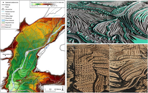
Geomorphology is the scientific study of landforms at the surface of the Earth (and sometimes other planets) and the processes that shape them (CitationGoudie & Viles, 2010). Geomorphologists seek to understand why landscapes look the way they do, to reconstruct landform history and dynamics, and to predict future changes through a combination of field observation, physical experiments and numerical modelling. Mark Macklin is a fluvial (‘river’) geomorphologist. Within geomorphology, interpretive mapping is most frequently used to delineate landforms that relate to specific earth surface processes and provide a relative chronology of land-forming events. Mapping can also be used in flood risk assessment to delineate low-lying areas prone to flooding and floodwater routes along river corridors. Over the past 20 years, there has been a revolution in geomorphological map making, primarily as a result of rapid developments in Earth observation and remote sensing technologies. These have facilitated a shift from interpretive geomorphological maps produced by walk-over surveys that take many weeks to complete and have limited ground based topographic data control, to LiDAR (Light Detection and Ranging) based aerial and satellite surveys that can survey huge swaths of terrain in a matter of a few hours with sub-centimetre accuracy (CitationJones, Brewer, Johnstone, & Macklin, 2007; CitationRoering et al., 2013). The juxtaposition of geomorphological maps produced by late twentieth century and twenty-first century mapping techniques () throws into sharp focus why recent technological mapping innovations have prompted considerable interest and use by the visual arts, including printmakers (). Indeed, when LiDAR-generated geomorphological maps and woodcut print blocks are put side by side (, Main Map), strong parallels and a high degree of convergence between the theory and practice of geomorphological mapping and relief printmaking emerge. The cutting and gouging of wood- and lino-blocks create line and shape to produce printed images on paper. The addition of pattern and texture then generate abstract and representational forms that capture the physical and palimpsest nature of the landscape, a water body or flow. To both authors, it came as a surprise that only after undertaking joint projects was there an emergence of this equifinality – or perhaps more simply put, common ground – in the use and representational importance of mark making in geomorphological mapping and relief printmaking.
Figure 1. Geomorphological maps of the Teleorman River, Romania (CitationMacklin et al., 2011) (left) and Tywi River, Wales (CitationJones et al., 2011) (right).
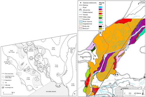
Figure 2. ‘Dyfi LiDAR’ (giclee with woodcut print by Judy Macklin).
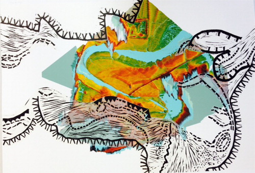
Figure 3. Geomorphological map of the Tywi River, Wales (CitationJones et al., 2011) (left) and lino- (top right) and woodblocks (bottom right) produced by Judy Macklin.
3. The ‘standard art-science’ narrative: the artist as communicator and the artist as observer
‘Art-Landscape Transformations’ was a 3-year (2008–2011) pan-European project on landscape, art and heritage that consisted of ten partners from across Europe and was financed by the European Commission Education, Audiovisual and Culture Executive Agency. The ‘Măgura Past and Present’ (see http://www.magurapastpresent.eu/ and CitationMills & Bailey, 2011) partner project was led by archaeologists from Cardiff University, UK (Steve Mills and Doug Bailey) and Muzeul Judeţean Teleorman, Alexandria, Romania (Pavavel Mirea). The project was centred on the Romanian village of Măgura, which had been the focus of the Southern Romania Archaeological Project (SRAP) since 1998. SRAP was a multi-disciplinary, international collaboration to examine trends in Neolithic and Eneolithic (6000–3600 BC) land-use, settlement patterns (CitationBailey, Andreescu, Howard, Macklin, & Mills, 2002) and river dynamics (CitationHoward, Macklin, Bailey, Mills, & Andreescu, 2004; CitationMacklin, Bailey, Howard, Mills, & Robinson, 2011) and was centred in the Teleorman River valley, 85 km southwest of Bucureşti, Romania.
The ‘Măgura Past and Present’ project, through the process of scientific and artistic interventions, gained new insight into the relationships that different groups of people (past/present, local/foreign, academic/lay) have with their physical environment. The region, though rich with historic and prehistoric sites and local cultural heritage, is poor in modern industry or other commercial terms. The authors’ joint intervention had three primary objectives, and each was realised through a series of artworks created by children at the Măgura School. First, we wanted to inspire in the children a sense of self. This was obviously contingent on them growing up in a rapidly changing agricultural community, in a small Romanian village at the beginning of the twenty-first century. Second, we wanted to develop with them a greater awareness of their sense of place through the lens of the local riverscape, in particular highlighting links with pre-history and human responses to past environmental change. Third, using modern and ancient found objects collected from the Claniţa River, we wanted to explore a sense of time using the river as a metaphor – a line of time.
To reinforce the notion of ‘self’, the children were given a number of replica Neolithic figurines from the local museum at Alexandria and invited to create their own figurines using self-hardening clay (). This promoted an investigation of identity to spark their imagination and get them to focus on form, shape and pattern. Wood and flint tools were used as a further reminder of what it might have been like to work with clay during prehistory, before the adoption and use of metallurgy. Drawings of the figurines were made in the children’s sketch books, along with notes on why and who first made these types of objects. To articulate a sense of place, the children were given large-scale colour aerial photographs of Măgura and the Claniţa valleys and were asked to interpret what they saw and to point out any anthropogenic or natural features in the landscape. Mark then demonstrated how aerial photographs and satellite images can be ‘read’ to produce cultural and environmental narratives, including the development of river landforms in the Claniţa and Teleorman valleys. The children put themselves in geographical context by identifying and marking on the photograph where they lived (). Nearly all of the children, with very little guidance, could do this; as none of them had seen an aerial photograph of this kind before, they demonstrated a high level of innate spatial awareness and abstraction (c.f. CitationMatthews, 1984). Building on this exercise, a larger-scale group piece was created, in which the children worked in willow charcoal and chalk to produce their own interpretative aerial representation of the village and its surrounding landscape ().
Figure 4. Aerial photograph of village of Măgura annotated by children marking the location of their homes (top left); Măgura children making self-portrait clay figurines with a replica Romanian Neolithic figurine in the foreground (bottom left); chalk and willow charcoal aerial drawing of Măgura and the Claniţa River produced by Măgura School (centre); and mixed media mosaic of the Claniţa River incorporating found objects and figurine self-portraits of Măgura village school children (right).
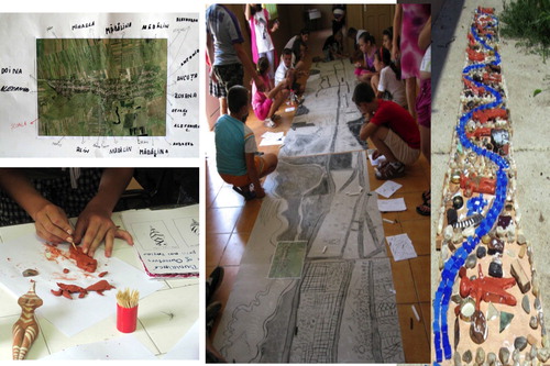
Creating an appreciation and understanding of deep time in the children’s imagination was the most challenging element of using participatory art-science activities to communicate the significance of the local archaeological heritage. This was achieved by a ‘walk and talk’ in which we took all 30 children along the banks of the Claniţa River and across the adjoining Islaz (floodplain common land) to collect contemporary human-made or ‘special’ (to the children) natural objects, to view Neolithic artefacts preserved in river deposits, and to discuss favourite haunts for playing and fishing. Children completed activities along the way, settling for a while at their favourite spots to make sketches or to gather plastic, ceramics, glass, shells and other contemporary ‘finds’. At the end of the guided walk, the children were shown a Neolithic site where contemporary river bank erosion had exposed a vast array of broken pottery, bone and worked flint. One of the additional purposes behind the children making their own figurines and gathering ‘finds’ from the Claniţa River was to represent themselves, as well as the past and present Măgura landscape, in the form of a group mosaic. This depicted the river walk, and was strategically constructed from 12 small (20 × 20 cm) wooden tiles that allowed the children to work in groups of two or three. To connect individual tiles, the course of the river was sketched and then marked by shiny, blue-coloured, glass tesserae. Next, the children washed and cleaned the contemporary ‘finds’, laying them out carefully to inspect them in a fashion reminiscent of archaeologists working at an excavation ().
The Măgura Past and Present project followed a conventional public engagement framework, with ‘the artist as the communicator’. If measured in terms of outputs (e.g. artworks, international conference and publications, new archaeological exhibition on the Neolithic in the City of Alexandria museum) and community outreach, the project was a remarkable success. As a time-limited (3 year) ‘intervention’, however, it did not meaningfully improve the explanation of archaeological science or offer new knowledge or avenues for creative investigation. This might be considered to be an overly harsh assessment but without post-project appraisal or longitudinal studies to measure ‘legacy’ in the local community – work that is rarely if ever undertaken – the long-term benefits of art-science projects of this type are difficult to quantify. Indeed, from the authors’ experience of being involved in a number of similar projects over the last eight years, they are more likely to raise expectations within the public that art and science communities either individually or collectively usually cannot realise.
Another example of what we have termed a ‘standard art-science’ narrative centred on the mapping of water movement and flow, and the importance of water in shaping land(s) and lives. This has been a long running theme of Judy’s work, inspired by river-based fieldwork in the Celtic ‘sacred’ landscapes of Ireland and Wales. A three-month residency at Amsterdam’s Grafisch Atelier in the summer of 2011, which coincided with Mark’s tenure of the Belle van Zuylen Chair at Utrecht University, resulted in a major exhibition entitled ‘Sacred river landscapes: form and process’ and production of a new body work (). Once again the artist was ‘implanted’ and acted as an observer in the laboratory (large scale flumes or physical models of river channels), in the field (as part of a Utrecht University project studying river channel patterns and water flow in engineered, former anabranching river systems in the Rhine-Meuse lowlands), and in a Geographical Information System (GIS) that gave access to Utrecht University’s Holocene palaeogeographic reconstructions of the Rhine-Meuse delta (c. 100,000 borehole descriptions; CitationBerendsen, Cohen, & Stouthamer, 2007).
Figure 5. Wood, lino-cut and chine collé prints from Judy Macklin’s ‘Sacred river landscapes: form and process’ 2011 exhibition at Amsterdam’s Grafisch Atelier.
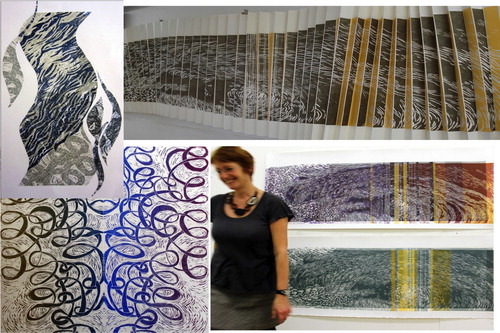
The fractal nature and repeating rhythmical patterns of river form and water flow emerge clearly in a series of woodcut, linocut and chine collé prints (). The use of chine collé (in which an image is transferred onto a surface that is bonded to a heavier support in the printing process) permitted printing on delicate Japanese paper that enabled the movement and eddying of water to be effectively represented in the work.
In the context of the emerging art-science paradigm, these Romanian and Netherland based projects at the time were seen as productive and innovative (as reported by CitationDixon, Hawkins, & Straughan, 2013). The authors’ (self) critical reflection, however, indicated that their collaboration had not achieved a ‘holistic’ status and highlighted that their working relationship had to become more than the sum of its disciplinary parts.
4. Towards ‘transdisciplinary/paradisciplinary art-geoscience’ narratives
The next phase of our collaboration was in the form of an art-science residency in the late summer of 2012 that was facilitated by an award from Joya: arte + ecología (http://www.losgazquez.com/joya-AiR). Joya: arte + ecología are an arts organisation based at Cortijada Los Gázquez in the heart of the Parque Natural Sierra María – Los Vélez in the north of Provincia de Almería, Andalucía. The guiding principle behind its activities is to facilitate, through production and collaboration, art and artists whose work manifests a discourse with the environment and sustainability.
Our theme was ‘Visual narratives of deep time in Las Ramblas’, and was the first art-science residency of its kind at Joya. Its aim was to explore long term (‘deep time’) human- environment interactions in the context of Las Ramblas – the iconic ephemeral rivers of southeast Spain – and seek common ground between art and science using landscape as a ‘bridge’. The significance of purposely starting a new and radically different phase of our working relationship in a Mediterranean context, where we had both developed and shared over a period of more than 35 years a deep appreciation of the interweaving of sky and water – described in our family as ‘blue-on-blue’ – was not lost. What also made this residency a point of departure from our previous working practice was the decision to conduct it in a transdisciplinary/paradisciplinary rather than interdisciplinary form, with the artist and scientist working together in the field and in the studio from a jointly conceived agenda and programme of work. Every aspect of working practice and process was documented in a daily blog, which formed a real-time record of how river landform and landscape data was collected, analysed and interpreted, and how through negotiation a portfolio of artwork and supporting text was produced. In conjunction with Simon Beckmann, co-founder of Joya: arte + ecología, a short film on the collaborative art-science residency was also produced (https://vimeo.com/52166655), which documents our transdisciplinary/paradisciplinary practice.
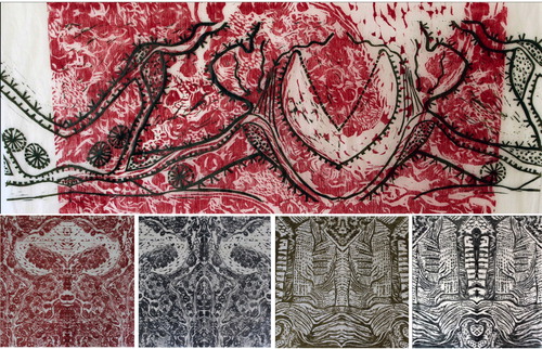
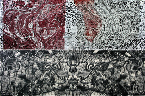
Interpretive geomorphological maps of the Rambla de la Tía Polonia catchment were produced from a walk-over survey and transcribed onto a Google Earth template, and then ‘sampled’ by Jude using a viewfinder to capture the fractal nature of the landscape, particularly as produced by running water. Representations of those parts of the Rambla de la Tía Polonia catchment that have been transformed by human action (primarily through the construction of agricultural terraces for water harvesting and soil conservation) were juxtaposed with ‘natural’ riverscapes that are found along the ephemeral river channels (Las Ramblas) (). This approach emerged after field-based discussions between the authors about the long-running debate of ‘humanity versus nature’ as the primary agents of geomorphological change in Mediterranean river catchments (see CitationMacklin & Woodward, 2009). One particularly important artistic innovation that was conceived during the residency as a device to help the viewer’s engagement of the landscape images was to transform, reflect and mirror them to create symmetrical forms akin to Rorschach’s well known inkblot test. This process liberated the still image to the extent that ‘spirit’, place-based and unique natural and anthropogenic qualities of these landscapes were revealed in an unexpected way. Indeed, the theme of ‘reflections’ has gone on to be an important part of our collaborative work in Australia, and particularly in New Zealand where image reflection on water is a significant part of the cosmogony, religious beliefs and rites, magic and folklore of the Māori.
Figure 6. ‘Confluence mirror map’ (wood-cut with chine collé print by Judy Macklin) (top); ‘Spirit of the Ramblas’ in red (bottom far left) and blue (bottom centre left) (wood-cut prints by Judy Macklin); and ‘Body of the land’ (bottom centre right) and ‘Bones of the land’ (bottom far right) (wood-cut prints by Judy Macklin).
The catastrophic floods that affected southeast Queensland in 2010–2011 (CitationCroke et al., 2013) and mid Wales in 2012 (CitationFoulds et al., 2014) provided the unlikely catalyst for exploring this ‘reflections’ theme by bringing together artists and scientists in flood-affected communities in Australia and the UK. This enabled evaluation of the benefits of art-geoscience in natural disaster mitigation and the understanding of climate change impacts on extreme hydrological events. The projects were expedited by scientific funding from the Natural Environment Research Council (who supported Mark’s research in the UK on the community scale impacts of flooding in the mid-Wales floods of June 2012) and the Australian Research Council (who supported a regional evaluation of the 2011 southeast Queensland floods and Mark’s tenure as a Visiting Professor at the Australian Rivers Institute, Griffiths University, Brisbane) but also jointly facilitated by a Wales Arts International grant to Judy. Dual funding permitted partnership on an equal basis between scientists (in this case, physical geographers) and artists (printmakers), which enabled a more ‘organic’ and, as it unfolded, a more sustainable long-term collaboration that is continuing to develop. Nineteen of Wales’s and Australia’s leading printmakers were invited to reflect on the impact of these catastrophic flood events on both their communities and themselves () through a print exchange entitled ‘Mythscapes in the watery realm’, with exhibitions held both in Aberystwyth and Brisbane.
Figure 7. ‘Avulsing Maranoa’ (top) (wood-cut print by Judy Macklin) and ‘Lockyer-Brisbane confluence’ (bottom) (wood-cut print by Judy Macklin).
The artistic outputs and text-based reflections from both artists and scientists in this collaborative programme were noteworthy for ‘fine tuning’ future trajectories of the rapidly developing art-geosciences agenda in at least two respects. First, the use of the visual arts, and artists, simply as a vehicle for conveying complex information from scientists and policy makers to the public was questioned. This centred on a concern that using artists simply as ‘go-betweens’ or ‘messengers’ can compromise them artistically and, potentially more detrimentally, leave them exposed when the public either questions the information being provided or requires answers that go beyond the technical knowledge of the artist concerned. Second, there was a consensus that artists and scientists working together can help individuals and communities to engage with emerging climate and environmental issues at local, regional and global scales by fostering greater public empathy and connection to the watery realm.
Mindful of the issues raised above, the authors are currently working on two new collaborative programmes – ‘Rivers of gold’ and ‘MyRiver’ – that are purposely exploring how art-geoscience may be able to go beyond using the arts simply as a vehicle for scientific ‘communication’. Both projects happen to have their starting points in the New World: ‘Rivers of gold’ in Australia, which is focusing on the environmental and cultural legacies of the nineteenth century Victoria gold rush, and ‘MyRiver’ in New Zealand, which is examining the environmental, economic and legal implications of the Whanganui River recently being granted the same legal rights as a living entity. Both projects are transdisciplinary configured in order to address some of the critical global challenges for the watery realm, which urgently require new ways of local interdisciplinary engagement.
5. Some recommendations for developing transdisciplinary art-geoscience collaborations
Nearly a decade of collaboration between ourselves has helped articulate what we now understand to be required for undertaking meaningful and productive collaborative art-geoscience projects, which importantly also have the potential to have credibility outside disciplinary boundaries. Obviously, this is a personal viewpoint but we do think it might go towards identifying good practice in art-geosciences more generally. First and foremost, art-geoscience must be a partnership of equals and both associates must respect the complementary skills and experience each brings to the collaboration. This cannot be in any way a sycophantic relationship, however, as self-criticism, and especially the ability to give and take positive and sometimes less-positive feedback to your working partner, are paramount. Second, an art-geoscience project that aspires to be transdisciplinary must be jointly conceived. For example, when new ‘field’ information is required this should be collected together, although the artist and scientist are likely to use their own working practice to capture ‘data’ (e.g. geomorphological mapping and sedimentary logging in Mark’s case, and continuous drawing, sketching, photographs and videos in Judy’s case). Third, preconceptions must be left behind but there should not be a fear of gently challenging the misconceptions of fact or working practice held by collaborating partner(s). Fourth, for field-based work undertaken outside of the artists’ studio or the scientists’ laboratory, a slimmed down and transportable ‘tool kit’ is required; with careful planning this does not need to constrain the ambition or reach of the creative output. Fifth, production of artwork and supporting text is best achieved coevally; blogging is an excellent vehicle for this and offers the opportunity for external feedback in near real time. Sixth, art-science projects work best if they are time limited (for ourselves at least) and can take place in a supportive and facilitating environment. Finally, what helped to sustain and guide our various art-geoscience interventions, in often unexpected and interesting ways, was ensuring they were locally ‘grounded’ within the community and aspired to address issues that had practical utility and benefit for human and ecosystem well-being.
6. Conclusions
This paper has critically explored a 40-year collaboration between a geomorphologist and a relief print maker, forged by a common passion for mapping and representing landscapes, from the perspective of the emerging art-science paradigm in geosciences. Drawing on the authors’ work and practice worldwide, what can be described as ‘standard art-science’ and emerging ‘transdisciplinary/paradisciplinary’ narratives can be identified. A case is made for a refocusing and rethinking of art-geoscience collaboration that build on disciplinary strengths and knowledge, with new studies emerging at the interface and ‘edges’ of the visual arts and geoscience disciplines. We argue that in this ‘space’, there is an equality of the unknown and a greater prospect for the development of real novelty, and significance, that reflects people-environment interactions, aspirations and anxieties for the twenty-first century inhabited Earth.
Acknowledgements
The authors would like to thank the following: Professor Doug Bailey, Dr Steve Mills and Dr Pavavel Mirea (Măgura Past and Present); Dr Kim Cohen and Professor Hans Middelkoop (Utrecht University); Donna and Simon Beckmann (Joya: arte + ecología); Dr Jacky Croke (University of Queensland); Jude and Harry Roberts (Mythscapes in the watery realm); Jennifer and David Stuerzl (Mythscapes in the watery realm); Marilyn and Marty Vreed (MyRiver); and Professor Susan Lawrence (La Trobe University; Rivers of Gold). They are also grateful for financial support from the Australian Research Council, Joya: arte + ecología, Natural Environment Research Council (UK), Massey University, Utrecht University and Wales Arts International. We wish to express thanks to Professor Harriet Hawkins and Dr Varyl Thorndycraft for refereeing our paper and the very helpful suggestions they made for improving the clarity of some of our thoughts.
Disclosure statement
No potential conflict of interest was reported by the authors.
ORCID
Mark G. Macklin http://orcid.org/0000-0003-4167-2033
Additional information
Funding
References
- Bailey, D. W., Andreescu, R., Howard, A. J., Macklin, M. G., & Mills, S. (2002). Alluvial landscapes in the temperate Balkan Neolithic: Transitions to tells. Antiquity, 76, 349–355. doi: 10.1017/S0003598X00090438
- Berendsen, H. J. A., Cohen, K. M., & Stouthamer, E. (2007). The use of GIS in reconstructing the Holocene palaeogeography of the Rhine–Meuse delta, The Netherlands. International Journal of Geographical Information Science, 21(5), 589–602. doi: 10.1080/13658810601064918
- Croke, J., Todd, P., Thompson, C., Watson, F., Denham, R., & Khanal, G. (2013). The use of multi temporal LiDAR to assess basin-scale erosion and deposition following the catastrophic January 2011 Lockyer flood, SE Queensland, Australia. Geomorphology, 184, 111–126. doi: 10.1016/j.geomorph.2012.11.023
- Dixon, D. P., Hawkins, H., & Straughan, E. R. (2013). Wonder-full geomorphology: Sublime aesthetics and the place of art. Progress in Physical Geography, 37(2), 227–247. doi: 10.1177/0309133312457108
- Foulds, S. A., Brewer, P. A., Macklin, M. G., Haresign, W., Betson, R. E., & Rassner, S. M. E. (2014). Flood-related contamination in catchments affected by historical metal mining: An unexpected and emerging hazard of climate change. Science of the Total Environment, 476–477, 165–180. doi: 10.1016/j.scitotenv.2013.12.079
- Goudie, A. S., & Viles, H. A. (2010). Landscapes and geomorphology: A very short introduction (Vol. 240). Oxford University Press.
- Hawkins, H. (2011). Dialogues and doings: Sketching the relationships between geography and art. Geography Compass, 5(7), 464–478. doi: 10.1111/j.1749-8198.2011.00429.x
- Howard, A. J., Macklin, M. G., Bailey, D. W., Mills, S., & Andreescu, R. (2004). Late-glacial and Holocene river development in the Teleorman Valley on the southern Romanian Plain. Journal of Quaternary Science, 19, 271–280. doi: 10.1002/jqs.805
- Jones, A. F., Brewer, P. A., Johnstone, E., & Macklin, M. G. (2007). High-resolution interpretative geomorphological mapping of river valley environments using airborne LiDAR data. Earth Surface Processes and Landforms, 32, 1574–1592. doi: 10.1002/esp.1505
- Jones, A. F., Brewer, P. A., Macklin, M. G., Swain, C. H., Bird, G., Griffiths, H. M., & Yorke, L. (2011). Late quaternary river development and archaeology of the Middle Tywi Valley. Report for Dyfed Archaeological Trust, p. 97.
- Lester, L., & Cottle, S. (2009). Visualizing climate change: Television news and ecological citizenship. International Journal of Communication, 3, 920–936.
- Liverman, D. (2010). Seeking inspiration: A scientist turns to the cultural sector. In Julie’s Bicycle (Eds.), Long Horizons: an exploration of art and climate change (pp. 21–25). London, UK: British Council.
- Macklin, J. E., & Macklin, M. G. (2011). Rivers – lines of time. In S. Mills (Ed.), Interventions: Măgura past and present (pp. 59–72). Bucureşti: Renaissance. Retrieved from http://orca.cf.ac.uk/id/eprint/28994
- Macklin, J. E., & Macklin, M. G. (2013). Deep reflections. Printmaking Today, 22(2), 31.
- Macklin, M. G., Bailey, D. W., Howard, A. J., Mills, S., & Robinson, R. A. J. (2011). River dynamics and the Neolithic of the lower Danube catchment. In S. Mills & P. Mirea (Eds.), The lower Danube in prehistory: Landscape changes and human–environment interactions. Proceedings of the international conference, Alexandria, 3–5 November 2010 (pp. 9–14). Bucureşti: Renaissance. Retrieved from http://orca.cf.ac.uk/id/eprint/39491
- Macklin, M. G., & Woodward, J. C. (2009). River systems and environmental change. In J. C. Woodward (Ed.), The physical geography of the Mediterranean (pp. 314–347). Oxford: Oxford University Press.
- Matthews, M. H. (1984). Environmental cognition of young children: Images of journey to school and home area. Transactions of the Institute of British Geographers, 9(1), 89–105. doi: 10.2307/621869
- Mills, S., & Bailey, D. W. (2011). What is Măgura? And who do we think we are? In S. Mills (Ed.), Interventions: Măgura past and present (pp. 13–40). Bucureşti: Renaissance. Retrieved from http://orca.cf.ac.uk/id/eprint/28994
- Roering, J. J., Mackey, B. H., Marshall, J. A., Sweeney, K. E., Deligne, N. I., Booth, A. M., … Cerovski-Darriau, C. (2013). ‘You are HERE’: Connecting the dots with airborne lidar for geomorphic fieldwork. Geomorphology, 200, 172–183. doi: 10.1016/j.geomorph.2013.04.009