
ABSTRACT
This paper outlines a collaborative project between a group of Fine Art and Geography students who helped develop and contribute to a conversation about recording ‘place’. Introducing methodologies from both disciplines, the project started from the premise of all environmental ‘recordings’ being ‘inputs’ and so questioned what could be defined as ‘data’ when encountering a location. Brunel’s Grand Entrance to the Thames Tunnel (London) provided the motivation for 10 objective and subjective ‘recordings’ which were subsequently distilled into a smaller subset and then used to produce a short film that was presented at an international conference. Important to the collaborative nature of the project were ongoing opportunities to share equipment, techniques, material and references across disciplines. It was an experiment to measure the potential for ‘mapping’ to capture physical and historical information, as well as embodied experience.
1. Introduction
Different academic disciplines have a range of methods and techniques that are commonly used to investigate phenomena. In chemistry, laboratory-based experiments might be involved, while in history a range of archival documents might be reviewed. In ecology, the natural environment might be mapped, whereas artists might use a broad range of techniques, both conventional and less conventional to the discipline but all being employed in direct response to the subject matter. Central to all disciplines are a standardised number of approaches that are used within specific scenarios; these methodological approaches often form practical (rather than theoretical) elements when students first learn these aspects of a discipline. As individual disciplines develop and particularly given the increasing prominence of interdisciplinary collaboration, there may be strong cross-fertilisation of ideas between disciplines, spawning new areas of investigation and exploration. For example, computer science research within the area of computer vision led to the development of a three-dimensional (3D) modelling technique known as ‘Structure from Motion’ (CitationSnavely, Seitz, & Szeliski, 2008). This has since been extensively applied within the geosciences to generate digital models of the landscape (CitationJames & Robson, 2012; CitationJavernick, Brasington, & Caruso, 2014; CitationWestoby, Brasington, Glasser, Hambrey, & Reynolds, 2012).
3D modelling is also extensively referenced in contemporary art; for example, in the work of Ed Atkins (‘Ribbons’, Citation2014, Serpentine Sackler Gallery, London). In December 2016, the Wysing Arts Centre in Cambridgeshire, UK, held a conference addressing ‘gaming’ (including its 3D modelling approaches) entitled ‘Meeting the Machine Half Way’. Anya Gallaccio’s ‘Beautiful Minds’ at the Thomas Dane Gallery in London, UK (March Citation2017) also addressed authorship and subversion of technology using a map of Devil’s Tower mountain to print a 3D model in clay.
Within the geosciences, there are a number of high profile art installations focused upon the environment (e.g. in the practice of Olafur Eliasson), although collaborations between artists and geoscientists remain less common (CitationTooth et al., 2016). For geoscientists, art provides alternative methodologies for investigation and a route for public engagement, while for artists, the geosciences offer rich subject matters from which they can draw inspiration.
Collaboration drives interdisciplinary work and, ultimately, the creation of new subject areas (e.g. behavioural economics, Geographic Information Systems) through challenging and rethinking existing frameworks. Such work infiltrates the methodological practices of established disciplines and eventually becomes part of their core curricula. By their nature, curricula are evolving, dynamic, entities and while they undergo change through time as a result of the integration of methods and practices from other disciplines, they also vary culturally. These natural changes and variations in curricula, the result of historical developments in different societies, present great diversity that adds to the number and range of degree programmes on offer to students. For example, geosciences in Italy have a strong emphasis on field mapping and cartography (e.g. CitationMancini et al., 2013), while art students in many countries are increasingly using creative technologies and addressing the ‘post-internet’ era (e.g. BA in Arts and Computational Technologies at Goldsmiths University, London).
Against this backdrop of mixed and complementary methods to inform and develop new practices, the lead authors of this paper (Smith and Parrott) sought to collaborate. Smith is a physical geographer whose research interests relate to 3D modelling of the environment with a specific focus upon glacial landscapes, while Parrott is an artist with interests in phenomenology and material experimentation. Smith has taught on both undergraduate and postgraduate Geography programmes, while Parrott has taught on foundation programmes in Fine Art. Their shared interest in both geography and exploring disciplinary practice led to the development of a project combining both subject expertise and the methods to which their students are typically exposed.
This paper presents the outcomes of a project combining Fine Art and Geography students from Kingston University who collaborated on an investigation of a geographical ‘place’. The project used methods and techniques common to each discipline, but unfamiliar to most of the participants. The intended outputs were a range of artworks, although it was anticipated that participants also would learn about new methodologies with a view to encompassing them within their own discipline’s body of knowledge (i.e. curricula).
2. Methods
The initial work focused upon selecting students to participate in the collaborative art-geoscience project, identifying a suitable study area to visit, and then developing a range of investigative techniques and undertaking data collection. This would then lead to the development of interpretative outputs and a final presentation. The project was collaborative between all participants – staff and students – as well as between disciplines. There was no intention for there to be a pedagogic underpinning to the work, but rather for individuals to be co-actors in the interpretation of a place. The production of artwork that explored the understanding and re-imagining of the study site that could then be further developed as a group was of primary importance. To emphasise: the project was not pedagogic research but aimed to use methodologies from both fine art and geography to develop and present new understandings. These steps are now outlined in more detail.
2.1. Student collaboration
Students were invited from both Fine Art and Geography programmes to respond to the concept of ‘reading’ a landscape or an environment and then develop individual and group methods of collecting data. The project was outwith to the students’ programmes of study, so carried no credit and was entirely voluntary. Students who accepted the invitation were jointly involved as collaborators between both themselves and with the academic staff.
Central to the collaborative work was the use of a site or location as a focal point: it would be viewed and analysed through the ‘lens’ of each discipline. In doing so, the group would have a new perspective on their methodologies, recognise parallels between what initially appeared to be polar disciplinary approaches, and also understand how methods of teaching and learning can be expanded and challenged through collaboration between different disciplines.
Approximately 30 Foundation Stage Fine Art students participated in an initial brief from Smith who outlined some of the approaches used in geoscience for recording and modelling landscape. Parrott then introduced the project and showed an example of a related work based in North Yorkshire titled ‘Dipole’ (http://www.floraparrott.com/dipole/). After this introduction, the students were asked to submit proposals of 300 words and two images explaining how they interpreted the project title of ‘Reading Landscape’ and how they would relate this to their own individual studio practice. Twelve students submitted proposals, with this group subsequently meeting regularly to discuss methodologies and approaches.
In tandem, Geography students at all levels were invited to join the project and participate in the interpretations that were being developed, as well as to contribute using a range of geoscience techniques. In total, four Geography students (two BSc, one MSc and one PhD) joined the larger group of Fine Art students.
2.2. Study site
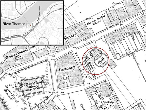
As ‘landscape’ was the focus of the collaboration, with students challenged to articulate their own ‘readings’, a process of study area selection was undertaken. To allow maximum participation, the only constraint was that the site should be close to Kingston University. Both human and natural landscapes were shortlisted, with the Grand Entrance Hall (http://www.brunel-museum.org.uk) to the Thames Tunnel at Rotherhithe selected. The Grand Entrance Hall is a 15 m diameter brick cylinder sunk into the right (south) bank of the River Thames () and was initially used as an access shaft for digging the Thames Tunnel before it subsequently became the main entrance (‘Grand Entrance’) to the Tunnel. The entrance lies on a peninsula in what was a heavily industrialised part of London () during the 1800s. The area was home to Surrey Docks, which supported maritime activities in London from the 1600s through to the 1970s. To the east is the Isle of Dogs peninsula and the heartland of the docklands part of London. The Grand Entrance Hall thus has a rich history, encompassing a unique interior space while also sitting within a well-defined urban environment. In short, it enabled a great deal of scope for interpretation and so the development of ‘readings’.
Figure 1. Historic 1:2500 Ordnance Survey mapping depicting the location of the Grand Entrance on the south bank of the River Thames in London (© Crown Copyright and Database Right 2017. Ordnance Survey (Digimap Licence)).
Marc Isambard Brunel (1769-1849), the father of the famous Victorian engineer Isambard Kingdom Brunel, formed the Thames Tunnel Company in 1824 with the intent purpose of building the world’s first tunnel under a river. Assisted by Isambard Kingdom Brunel, work started in 1825 at Rotherhithe with the construction of the Grand Entrance. All the funds of the company were exhausted by 1828 and it was not until 1834, with a government loan, that work restarted (CitationBrindle, 2013).
With great fanfare, the Tunnel was opened to the public in 1843, and the Grand Entrance provided suitably impressive access to what was described as the ‘eighth wonder of the world’ (CitationBrindle, 2013). With London having rapidly expanded to over two million people by 1841, more than one million people traversed the Tunnel within three months of its opening, firmly establishing the Tunnel as a major tourist attraction (CitationBrindle, 2013).
In 1865, the Tunnel was purchased by the East London Railway Company and the Grand Entrance was converted to a ventilation shaft and lay dormant. In 2005, the Brunel Museum was established with the express purpose of conserving the structure and opening it to the public (as a sealed chamber). This re-opening took place in 2011.
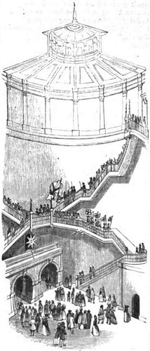
The chamber itself is very simple, a product of its construction. The River Thames sits on top of sands and gravels in the Thames basin (CitationMathers et al., 2014), and an access shaft was needed in order to reach a sufficient depth beneath the river bottom. A circular wall was built up, row by row, with the weight of the structure causing it to slowly sink into the substrate; construction continued until the required depth had been reached, at which point the tunnelers broke through at the base and began digging manually. After completion, the shaft then served as the Grand Entrance () with a double staircase fitted in the interior to provide suitably ornate access to the foot tunnel below. As a result of its construction, the space retains visible traces of its past on the walls; the evocative interior is starkly different from the surface level where it is accessed.
Figure 2. Artist’s impression of the Grand Entrance to the Thames Tunnel (Anonymous, Illustrated London News 1843, https://en.wikipedia.org/wiki/Thames_Tunnel).
2.3. Investigative Techniques and Data Collection
Following the selection of the study site, the students were able to refine their plans. Consideration was given as to how the potentially wide-ranging ‘data’ might be collected and pooled in order to develop a collaborative response to the site.
The Geography students’ approaches to data collection included the compilation of a range of historic and contemporary maps of the site at a range of scales (e.g. ), geological mapping of the area, and detailed surveying of the chamber itself. The detailed surveying used two approaches. The first, plane tabling, locates the positions of individual points within a site which can then be used to produce a scaled plan. This moderately accurate technique (±10 cm) was contemporary to the construction of the tunnel and would have been used by Marc Brunel. The second, photogrammetry, involves the use of large numbers of photographs to digitally reconstruct the 3D geometry of the chamber.
The Fine Art students’ approaches to data collection were designed to incorporate ideas of both measurement and opinion, enabling a range of interpretations to be constructed. These included photographs of the site, audio recordings of the ‘soundscape’, time-lapse video of the group working, sketched drawings of the entrance and people within it, a group questionnaire that would be used to generate a word cloud, latex casts (preserving the texture of the chamber), and helium balloons to measure chamber height. In addition, the door of the chamber was converted into a pinhole camera, and the image projected onto the chamber wall, which was then photographed.
3. Results
The field trip to the Grand Entrance Hall was organised for a single day, and the group was given unrestricted access over a four hour period. The ‘readings’ devised by the Fine Art and Geography students were undertaken during this time, with students and staff working individually or in small groups to collect the range of different data sources during intense and focused activity. The approach encouraged in Fine Art studios is to be led by intuition, with students being asked to research broadly and navigate their ideas using practical and responsive methods. The outputs are not easy to define but the processes have a rationale and key themes can be tracked through the experiments, references and activities. In contrast, many Geography students are more used to working from a research hypothesis and then following a methodology that can provide quantitative evidence to test the hypothesis.
Discussion during the pre-field trip sessions suggested that the Fine Art and Geography students were both fascinated and possibly slightly intimidated by each others’ techniques, as the process of producing a ‘recording’ in each discipline could be seen as antithetical. The field trip was energetic and dynamic, however, with non-stop activity taking place in order to complete all of the ‘recordings’. The results were immediately recorded on a blog (http://rotherhitheshaft.tumblr.com/) and became the foundation for a follow-up workshop.
The following subsection outlines the individual projects from the field trip, listing the participants of each project and whether they had Fine Art (FA) or Geography (G) backgrounds, and illustrating some of the outputs ( and ; see also Supplementary Materials). Some of the outputs formed elements of the later workshop and final project film, as detailed in subsequent sections.
Figure 3. Examples of outputs from projects undertaken in the Grand Entrance: (a) 30 cm diameter helium balloons used to measure the height of the chamber; (b) word cloud generated from descriptive feedback; (c) interpretive sketches of students undertaking fieldwork; (d) sketches by Natalie Wyle of magnified nuances within the chamber (e.g. architectural detail, erosion and patina); (e) plane tabling and photogrammetry data collection on the floor of the chamber; (f) frame from video output of walking transects of the floor of the chamber; (g) one of the latex casts from the wall of the chamber.
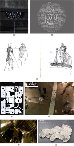
Figure 4. Output plan from the plane tabling exercise.
3.1. Individual and small group projects
James O'Connor (G) and Mike Smith (G): 3D Reconstruction of the Main Chamber
Over 200 photographs were taken using a Nikon D700 camera combined with three fixed flashguns. The images were then processed using Agisoft PhotoScan to create a 3D ‘cloud’ of points modelling the actual shape of the chamber (e; Supplementary Materials 1 Film).
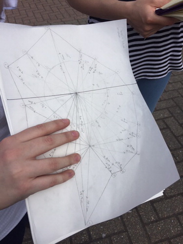
Anna Bond (G) and Lucy Ewers (G): Plan Form Survey of the Floor
Using the traditional plane tabling technique, targets were temporarily affixed to the walls and surveyed from each of two locations. The graphical measurements () were then later manually converted into a scaled plan diagram of the floor of the entrance hall ().
Flora Parrott (FA): Reflective Helium Balloons
Figure 5. Creation of a larger scale plan of the Grand Entrance based upon the plane tabling output.
This approach was inspired by a review of material in the Cave Science journal (CitationWorthington, 1987), undertaken during research in the RGS-IBG collection. The helium balloons were used to measure the height of the chamber but also as a visual prompt to discuss the boundaries and materials within the space ((a)).
Robin Tarbet (FA) and Hope Barraclough (FA): Latex Casts
For this work, casts were made of the walls of the entrance using plasticine, with plaster then used to fill the mould. The resulting casts (with residue from the walls of the shaft – (g)) became useful points of focus during the later workshop session (see below).
Issy Veysey (FA): Word Clouds
Participants in the field day were asked to write down a series of words in response to the experience of being in the chamber. The written responses were used to make word clouds ((b)) and concrete poems (shape poetry), the latter becoming the voiceover for the subsequent film (see below).
Stanley Welch (FA) and Anna Longworth (FA): Sound Recordings
Participants in the field day were asked to make a series of noises in the chamber to see how the space affected sound. The sound experiments included whistling and clapping and were recorded using a camera and audio recorder.
Felix Hall Close (FA): Camera Lucida
Some students had investigated analogue photography processes as part of the Foundation Stage Fine Art course. Hall extended what he had learnt, taking the opportunity to use the chamber to create a Camera Lucida (pinhole camera) on a large scale. The door of the chamber was masked with a bin liner, and a small hole in the centre was then used to create a lens. The image was projected on to the wall of the shaft and then photographed.
Joanna Hooper (FA), Anna Monkman (FA) and Natalie Wyle (FA): Interpretive Sketches
These students made interpretive sketches, each setting their own parameters and undertaking the work in response to the site and the project activities. Sketches were made using a range of materials including ink, pencil, pen and paint, and some were figurative (c) and others architectural (c). Monkman reflected upon the early stages of fieldwork:
Whilst in the shaft I observed and recorded the different range of activities going on in the space. It seems the breadth and depth of different people’s interpretations and readings will be vitally important when reviewing our time there and trying to retell and interpret the space as we remember it.
Joanna Hooper (FA): Time-lapse Photography
A camera was placed on the balcony overlooking the chamber in order to collect time-lapse imagery (f) and then create a video. The work was made with the intention of capturing the movements in the space.
Leonie Rousham (FA): Comparative Spaces
All participants in the field day were instructed to measure their bedroom prior to the visit and to then reapply these dimensions within the Grand Entrance Hall using tape on the floor. Rousham’s work responded broadly to themes of procession, navigation and choreography of the city. It was a transient piece, marking out the spaces in tape on the floor of the chamber. The lines were photographed and used in the final film (see below).
3.2. Workshop
Several weeks after the field trip, the group spent a day working through the project outputs at the Stanley Picker Gallery (http://www.stanleypickergallery.org). This way of working mirrors the group critique sessions used to analyse and develop ideas in Fine Art studios.
Using the works of Gordon Matta-Clark, Hamish Fulton and Lindsay Seers as a point of reference, we discussed the implications of terminology, along with the strengths and weaknesses of each process of ‘recording’ and ‘reading’ in the different projects. The students worked in two breakout groups to further develop the outputs, expanding and abstracting the ideas. The tasks had no specific rationale but in carrying them out, space for discussion was created. As the students had become more familiar with each other by this point, they felt able to ask direct questions about the processes used in the space without feeling that lack of knowledge in another discipline was a barrier.
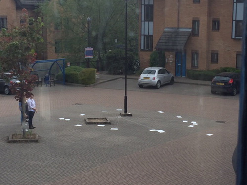
As an example, one group took the results from the plane tabling project and used them to map the Grand Entrance Hall at 50% scale in the gallery car park (). During this time, staff overheard conversations between students about the importance of practical application and fieldwork in both disciplines.
Another task was to map a section of the 3D photogrammetric model onto the wall in the gallery space using the point cloud data. The pipe from the wall was detached from the model and simplified; this became a pivotal discussion in the making of the final film (see below) and was then combined with the audio soundscape. It also presented an opportunity for O’Connor, as he found new ways to work with technologies that he uses on a daily basis. He noted:
Within computer science a very typical task undertaken is to try and structure data by dividing its contents into various groups sharing some common information (classification). During the discussions yesterday I noted a few people interested in the fact that science looks to always patch out errors in algorithmic classification, whereas artists can embrace them.
3.3. Final output
The workshop allowed students to expand their ideas and be influenced by the collaborative nature of the session, and it is clear that there was potential for further discussion. In addition, the group was provided with the opportunity to present some of the project outputs at the Royal Geographical Society (with the Institute of British Geographers) Annual Conference in London (August 2016). A smaller group comprised of authors Smith, Parrott, O’Connor, and Rousham, along with Monkman and Veysey, therefore met on two further occasions. Early in discussion it was decided that a short film would provide a good medium to combine and present the range of different ‘recordings’ and ‘readings’; there was no sense of hierarchy or ownership, but rather shared concern with how best to communicate the awareness of place and include as much information as possible. The 3D representation of the Grand Entrance, integrated with the plane table survey, provided the structure for the film. Other interpretations were integrated, ranging from an audio overlay resulting from the questionnaires, an historical account of the Tunnel, and visual representations of the different ‘recordings’. There was little discussion within the group about the differences between geography and fine art practice, but instead, there was a sense of symbiosis and shared intent, with a focus upon communicating both the outcomes of the project and sharing interpretations of the place.
The non-exacting and elusive ways in which we perceive a place as individuals is the central theme of the short film. The ideas that we bring to bear, employ consciously and sub-consciously, and then merge to form our own set of parameters are key to our response at each and every location. This response is uniquely formed, encompassing and employing the historical dimension that is embedded there. The tensions between these streams of information are what the film attempts to make transparent.
4. Discussion and conclusions
4.1. General outcomes
Beyond the development of personal practice by individuals, it was clear that the mixing of students and staff on different academic programmes had generated a surfeit of ideas, culminating in the extensive range of activities in the Grand Entrance. This then spawned the development of responses to the site () which were finally distilled into the short film that explored these themes. These various outputs explored both geographical and cultural dimensions, as well as our collective response to, and understanding of, a place.
Each participant in the project provided new and interesting insights but taken collectively these create an understanding that is greater than any individual element. Indeed, this should be the nature of interdisciplinary work: we not only bring our own approaches, but absorb those of our contemporaries and, jointly, develop something that is more expansive, more powerful and, ultimately, more explanatory.
4.2. Future improvements
The project required students to give up much of their free time to work on developing their ‘recordings’ and while it was not a credited part of their courses, for the Fine Art students, the experience and outputs may have contributed to their studio work. University courses are primarily focused upon quantifiable outcomes and vocational relevance; the project delivered on neither of these and yet was of great value and significance to the participants. This was demonstrated during the development, fieldtrip and workshop sessions in which the students worked collaboratively and efficiently. It was interesting and encouraging to see how enthused the students were about the opportunity to work with those from another discipline and explain and explore their own discipline’s subjects for the sake of knowledge rather than university credits.
The quality of the project outcomes is a testament to the enthusiasm of the participants, but the project overall was not undertaken without difficulties. As the project was non-credit bearing, there was relatively little interest from the student body as a whole, as evidenced by the relatively small number of participants. As the work focused upon fine art, naturally there was greater interest from these students and a relative lack of Geography students. This imbalance meant that the majority of the project components came from the fine art perspective. Had there been more Geography students, perhaps the Fine Art students would have had to find new modes of framing and explaining their methods rather than working intuitively. Furthermore, the numbers of participating students dwindled as the project progressed from initial outline, to preparation, to field day, to workshop, to film production. That said, the quality of input from participants at each stage continued at a high level; they were dedicated to the project.
Careful consideration was given to the selection of the Grand Entrance as a study site, but in retrospect, it is clear that access to a confined interior space limited both time on site and the methodologies employed. Our preference would now be to utilise either an outdoor urban or rural location. Finally, while this was a project about the co-production of fine art with students as active participants, an androgogic aspect would have allowed us to qualitatively assess the benefits to the students and therefore develop the project in subsequent years, with a view to developing a joint credit-bearing module that students from different disciplines could take.
4.3. Final thoughts
For Fine Art practitioners, the ability to spatially organise, reference, disassemble and then regenerate a location provides a multitude of powerful ways to understand a place. For Geographers, understanding there are multi-faceted ways of responding to a location and that these responses can be generated and explored in a range of non-exacting and discursive methodologies is important. Interdisciplinary work is about understanding and appreciating the expertise and experience of colleagues in other disciplines, and wrapping the insights into our own disciplines so that we can push the boundaries of what is understandable and achievable.
It may sometimes appear in art-science collaborations that the artists are simply harvesting information from the sciences in order to make art works. The outcomes are elusive and often only filter back into the studio in a meaningful way years later. Our collaborative project, however, created a much more blurred exchange, a space in which two disciplines were asked to challenge the frameworks that over time become invisible and limiting. The nature of fine art research and practice makes it, at first glance, a difficult pairing with scientific disciplines that employ analytical methods. Nevertheless, the energy and experimental nature of fine art can subvert and open other disciplines to ways of working that can challenge and ultimately improve working methods.
Software
Agisoft PhotoScan was used for the production of the 3D model, with the manipulation of point clouds in Cloud Compare. Final film production was undertaken using Blender.
Supplemental video
Download MP4 Video (39.7 MB)Acknowledgements
The authors gratefully acknowledge the enthusiasm and hard work of all the students who participated in this project.
Disclosure statement
No potential conflict of interest was reported by the authors.
ORCID
M. J. Smith http://orcid.org/0000-0003-4719-8651
J. O’Connor http://orcid.org/0000-0003-2132-3688
Related Research Data
References
- Atkins, E. (2014). Ribbons. London: Serpentine Sackler Gallery.
- Brindle, S. (2013). Brunel: The man who built the world. London: Phonex Press, 196p.
- Gallaccio, A. (2017). Beautiful minds. London: Thomas Dane Gallery.
- James, M. R., & Robson, S. (2012). Straightforward reconstruction of 3D surfaces and topography with a camera: Accuracy and geoscience application. Journal of Geophysical Research: Earth Surface, 117.
- Javernick, L., Brasington, J., & Caruso, B. (2014). Modeling the topography of shallow braided rivers using structure-from-motion photogrammetry. Geomorphology, 213, 166–182. doi: 10.1016/j.geomorph.2014.01.006
- Mancini, F., Dubbini, M., Gattelli, M., Stecchi, F., Fabbri, S., & Gabbianelli, G. (2013). Using unmanned aerial vehicles (UAV) for high-resolution reconstruction of topography: The structure from motion approach on coastal environments. Remote Sensing, 5, 6880–6898. doi: 10.3390/rs5126880
- Mathers, S., Burke, H., Terrington, R., Thorpe, S., Dearden, R., & Williamson, J. (2014). A geological model of London and the Thames Valley, southeast England. Proceedings of the Geologists’. Association, 125, 373–382.
- Snavely, N., Seitz, S. M., & Szeliski, R. (2008). Modeling the world from internet photo collections. International Journal of Computer Vision, 80, 189–210. doi: 10.1007/s11263-007-0107-3
- Tooth, S., Viles, H. A., Dickinson, A., Dixon, S. J., Falcini, A., Griffiths, H. M., … Whalley, B. (2016). Visualizing geomorphology: Improving communication of data and concepts through engagement with the arts. Earth Surface Processes and Landforms, 41, 1793–1796. doi: 10.1002/esp.3990
- Westoby, M., Brasington, J., Glasser, N., Hambrey, M., & Reynolds, J. (2012). Structure-from-Motion photogrammetry: A low-cost, effective tool for geoscience applications. Geomorphology, 179, 300–314. doi: 10.1016/j.geomorph.2012.08.021
- Worthington, S. (1987). Review of cave surveying techniques. Cave Science, 14, 56–59.