
ABSTRACT
This paper outlines a project drawing together an artist working on creative GIS, a geomatics scholar, an NGO leader, a rural geographer and soil scientist, an environmental geochemist, and a political geographer. With a shared interest in the social and physical processes affecting people’s lives in Malawi, and the possibilities for interdisciplinary collaboration, the team engaged in practice-based mapping of our data sources and respective methodologies. The project relates to two sites in Malawi: Tikondwe Freedom Gardens and the Likangala River. The paper details our practices as we shared, debated, and repurposed our data as a means of situating these practices and data. Using paper and pen, whiteboard, PowerPoint, and web-design software, we note here our effort to map a ‘space of experimentation’ highlighting, and reflecting on, our diverse disciplinary orientations, training, instrumentation, recording, and reporting procedures, as well as bodily practices that enable and give animation to these factors.
1. Introduction
Art-science collaborations are a rapidly emerging feature of academia, fuelled in large part by a perceived need to facilitate the communication of scientific findings and practices to diverse publics using a range of means and mediums (CitationLesen, Rogan, & Blum, 2016). The current political context of science scepticism – especially in regard to climate change – amongst several administrations (such as the US and Australia) has sharpened what was formerly an issue of disseminating scientific findings into an oftentimes fraught process of conveying (and defending) what scientific practice consists of, and of asserting why science matters across a spectrum of issues (CitationDunlap, 2013). Also, art-science collaborations have been energised by a desire to re-awaken long buried emotive dimensions of scientific practice such as ‘wonder’ (CitationBaker & Twidale, 1991; CitationGordon, 2012; CitationGordon & Baker, 2016), and an awareness of the ontological complexities of the Anthropocene, wherein efforts to disambiguate human and physical processes and events are registered as a “spurious or a meaningless vestige of Cartesian dualism” (CitationBrown et al., 2017, p. 85). In regard to the earth sciences, CitationDixon, Hawkins, and Straughan (2013, p. 238) argue that a key factor in this rising engagement with art and artists, and an attentiveness to earth science's own aesthetic histories and legacies, is a shared curiosity around “particular landscapes (some extreme, others considered mundane) that are considered complex in the sense that they prompt uncertainty over and against surety, as well as an acknowledgement of how this uncertainty has been narrativized in diverse ways across the disciplines”. That is, they suggest that there is a felt mismatch amongst scholars between the narrow problem defining and methodological strictures of disciplinary approaches that they have been trained in, and the multi-faceted nature of the landscapes that they seek to interrogate and re-present.
Uncertainty is an intellectual challenge – it is a provocation to thought – and as such has prompted scientists to look at other disciplinary expertise, as well as to statistical techniques to quantify uncertainty in their data sets (CitationFischhoff & Davis, 2014). Small wonder, then, that interdisciplinary collaboration has emerged as a means of gaining a more ‘holistic’ understanding of complex landscapes that incorporates the work of numerous processes across different spatial and temporal scales, and that acknowledges the interpretive limitations therein. In addition, uncertainty is an emotive and affective condition, prompting, as CitationDixon, Hawkins, and Straughan (2012) intimate, reflection on the process of knowledge production itself, such that particular narratives are articulated, but also the manner in which research is practiced. Clearly, this is a cognitive process, but also an embodied one, supplemented by a variety of apparatuses and technologies that enable data collection, analysis and representation. What is more, uncertainty in this context refers to much more than a felt need for more information on a given landscape, as it is thoroughly entangled in other emotive states; for example, a desire to speak to matters of pressing local concern and to a varied audience, such that research ‘matters’ beyond the academy. Indeed, a key contribution from the humanities has been to highlight and value, as well as critique, the world-making ambitions of science (e.g. CitationIngold, 2013).
Certainly, our grouping was motivated by a shared concern with what might be termed a ‘geo-violence’ (Zur, Citation1999) in Malawi, where past and current geopolitical conflict, global capitalist development, land governance and management, and complex environmental crises associated with climate change intersect to effect a slow violence upon the body, as well as the communities of which those bodies are a part (CitationHall et al., 2015; CitationNshimbi, 2019). Four of our group – an artist working on creative Geographic Information Systems (GIS) (Nicholson), a geomatics scholar (Barrett), an environmental geochemist (Long) and a political geographer (Dixon) – are based in the same academic school (Geographical and Earth Sciences) at the University of Glasgow, Scotland, while a fifth person (Moyo) gained his PhD in Geography from this same school before returning to Malawi to lecture on natural resources and agriculture. As part of the broad-based ‘Sustainable Futures in Africa Network’ (https://sustainablefuturesinafrica.com/), we were able to access the expertise of one of Malawi's foremost non-governmental organisation (NGO) leaders (Pullanikkatil). Given our shared concern for understanding the multiple stresses, both physical and social, impacting upon individuals and groups in Malawi, we very much wanted to build a large project proposal together. Yet, how would we envision working together? What forms of collaboration were possible, and what was desirable?
As researchers trained in disparate disciplines, a shared interest in having our research opened up to the gaze of other group members was a matter of both optimism – that our research could actively contribute to the work of others – and anxiety, insofar as uncertainties as to how this would be undertaken, and with what import, abounded. Over the course of five months, and comprising an initial scoping meeting in Gaborone, Botswana, and an intensive workshop in Glasgow, interspersed with email and Skype correspondence, we determined that our collaboration would strive to avoid what CitationFitzgerald and Callard (2015) call the ‘arid’ regime of the ‘inter-’, wherein a fundamental gap is presumed to operate between disciplines before teamwork somehow bridges this divide by providing a synthetic metanarrative. Rather, we would aim to explore the uncertain, dialogic, embodied practices that we all undertook to produce knowledge. Why?
Our decision was that to enable a productive research relationship to develop we needed to focus on the practice of knowledge production as a means of addressing the often-glossed conceptualisations, methodologies, inspirations, terminologies, anxieties and frustrations that already exist between apparently discrete disciplines. This focus on research practice could be addressed, and developed, by adopting a practice-led approach to the mapping of our existing datasets, our well-used methods of data collection and analysis, and, by extension, ourselves as researchers in relation to our now repurposed data and to each other. CitationFitzgerald and Callard (2015) refer to this approach as a mode of ‘experimental entanglement’ in that it brings to the fore small areas of activity that precede, or escape capture in, strict labelling or classification systems. CitationFitzgerald and Callard (2015, p. 17) suggest these are “spaces of experimentation in which the intersections between scientific ‘objects’, instruments, apparatuses and experimenters still quiver with uncertainty”. For CitationLast (2012), such experimentation is a risky prospect in that if there is no set expectation regarding how research is to be appropriately undertaken, or assessment criteria for outcomes, then there can be no accounting of the success or failure of a given project. Nevertheless, CitationLast (2012) also suggests that a reappraisal of disciplinary aesthetics, past and present, alongside a ludic approach to conventional registers and formats, allows for reflective, critical commentary on knowledge production and the possibility for new narratives of people and place to emerge, such as researchers and their research sites.
2. Talking about data, producing new narratives
To ground our debates, and to help us to reflect upon our own disciplinary training and anticipations, we determined to pull together data we already had on two particular sites in Malawi – Tikondwe Freedom Gardens and the Likangala River – and to interrogate how and in what form these data sets had been produced. These sites were selected for the wealth of data we had available. Moyo, for example, has managed soil analysis, vegetation mapping and key informant interviewing at Tikondwe Freedom Gardens over the past ten years, pursuing research into indigenous farming knowledges and practices (CitationMoyo & Moyo, 2016). Pullanikkatil has used surveys and community mapping to research environmental and human wellbeing relations in the Lake Chilwa Basin of Malawi where most communities are natural resources dependent, through her non-profit organisation Abundance (www.abundanceworldwide.weebly.com). She has carried out water quality analysis of the Likangala River that flows from Zomba Mountain, through agricultural, urban and wetland regions into the lake (CitationPullanikkatil, Palamuleni, & Ruhiiga, 2015, Citation2016).
summarises our process over the course of a three-day workshop in Glasgow, prior to which we had assembled all manner of data sets – from water quality reports to satellite imagery, and from regional histories to site photographs – into a shared drive. We began by talking about how these data had been collected, noting the practicalities involved, such as gaining access to field sites and depositories, before moving on to a discussion of the embodied labour process involved. For the scientists in the group this was a challenging task, as it raised the singular experiences involved, as opposed to the replicable process that is normally written up in science publications. Following accepted scientific methodologies in the earth and environmental sciences is crucial, as data and analyses must be replicable to be considered valid and comparable to other studies. Gradually, however, and prompted by Nicholson, two thematics emerged. First, the complex materialities through which earth processes and events become known and articulated. These comprised the samples (e.g. soil, water) collected, the recording and interpretive equipment deployed in the field and laboratory, the classification systems (computer and hand drawn tables and maps) adopted, and the mediums (typed reports, PowerPoint presentations) with which datasets were assembled and disseminated. Second, the manner in which different modes of data collection (coring, slicing, sampling, listening, watching) and representing (writing, drawing, timing, digitising) were underscored by our imaginaries of how processes worked, and why and in what context some aspects of the landscape, or events, were understood to be of significance.
Figure 1. Flowchart illustrating the key steps undertaken in the creation of two story maps from our collaborative project.
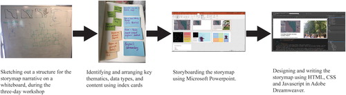
Having reflected on our research practices, and identified particular events and objects, activities and assumptions, we determined to map out some of our data and methods so that we could show how these materialities and imaginaries not only found resonance, but also sometimes were at odds with each other. As indicated in , we used pen and paper, whiteboard, index cards and finally Microsoft PowerPoint to place these events, objects, activities and assumptions over and against each other. Each new configuration effectively remapped these components, prompting new discussion on the nature of knowledge production, and the opportunities and challenges therein. In taping these ensuing conversations and extracting audio, and filming new activities such as the shared drawing of a soil profile, we added yet more data to our collection.
Following the workshop, and having experimented with available GIS-based story map software, Nicholson and Dixon undertook to build two story maps (using Adobe Dreamweaver to integrate HTML, CSS and JavaScript) of our process – one for Tikondwe Freedom Gardens, and one for the Likangala River – and some of the new narratives off (or of the) site that we produced. For Nicholson and Dixon, these two story maps are a means of documenting our collaborative process – bearing in mind such documentation is intended to convey a sense of ‘what might be’, as opposed to a setting in stone of ‘what has been’ (CitationNelson, 2013) – and a means of experimenting with the diverse spatialities of our extant research processes. Story maps allow us to: experiment with ideas around proximity and distance between the observer and the observed; consider the manner in which particular technologies deployed scale, zoom, juxtaposition, and point of view to locate objects of analysis and shape their apprehension; feel the effect produced by foregrounding, transforming and formatting particular features; and speculate as to how the sensory engagements that underpin both field and laboratory work could be invoked by the spatial and temporal layout of still image, video, text and sound. In the next section, we describe aspects of these story maps as they appear on screen to the viewer.Footnote1
3. Story mapping sites as a space of experimentation
Much group discussion hinged on how we would design entry points into the story maps, insofar as these would provide a cognitive and affective setting for what followed. We did not wish to provide an introductory text describing the geolocation and chronological history of each site, as we felt this would have provided an uncritical, fixed, Euclidean framework within which each site was to be further described and pinned down. Rather, we talked about what was a key feature of each site as an object of analysis for us as researchers, and then about how we could intimate this feature to a viewer without closing off speculation as to what each site was indeed comprised. Reviewing our collected data sets time and again, we finally decided that for both story maps the entry would be a simple line, the nature of which would be transformed via an animated sequence.
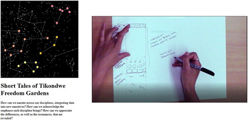
As shown in , for Tikondwe Freedom Gardens, the story map begins with a straight and curved line, intimating, we intend, the idea of contrast between what are now two spaces either side. After two seconds, this idea of contrast is further attenuated by the emergence of a two-coloured box dissected by the line. After another two seconds, an aerial image fades into view, softening the overall colour palette of the screen, but now specifying the line as a border between more verdant and less verdant landscapes. The straight section of the line – now interpretable as an anthropogenic feature – prompts speculation as to the human impact on the landscape responsible for its creation, but also, we intend, an awareness of what the viewer's position now is in relation to this site. The delayed introduction to the aerial view – a view that is often presented to scientific audiences uncritically as a comprehensive representation of a site – allows for the recognition of what is in fact an embodied, technologically facilitated, viewpoint.
Figure 2. Introductory animation sequences for the story maps for Tikondwe Freedom Gardens (above) and the Likangala River (below).
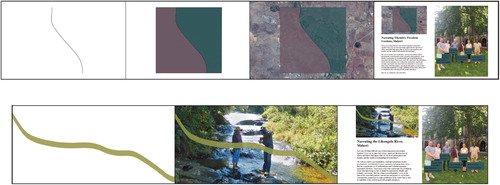
For the Likangala River story map, we again begin with the line, though much thicker in form, indicating some substance (). In the story map, the line is seen to emerge from the bottom right of the screen and travels to the top left. After three seconds, an image emerges showing two people standing mid-flow, and the line becomes interpretable as a river long profile.Footnote2 Our intent at this point is to instil a feeling of curiosity prompted by the question: why does the long profile run bottom to top? As becomes clear further into the story map, for us the river is a complex object, the history of which can be interrogated ‘backwards’ from the mouth of the river to its head, for river samples give us an insight into the conditions in the catchment upstream of the sampling point. With this entry to the story map, we intend to foreshadow this mode of knowing a river but also to prompt reflection on how a traditional long profile is generally ‘read’, which is an anthropocentric ‘biography’ of a river that conflates direction of flow with birth and death.
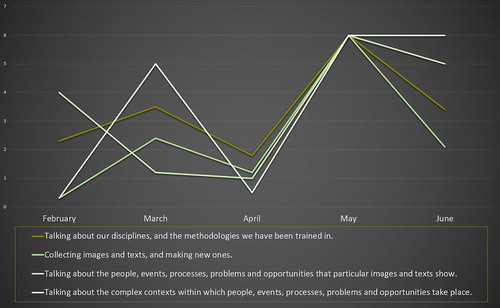
Both animations segue into an introduction to the team () and a brief note on our intent, which serves as an introduction to our activities and discussions around research practice and data ( and ). Both story maps present the same basic material, which is a general account of our collaborative process. For Tikondwe Freedom Gardens, however, we wanted to juxtapose the satellite image from the opening animation with another gaze, but this time a gaze emerging from the site. Using data from the ‘Your Sky’ site,Footnote3 we created a map of the constellations seen from Malawi, looking upward, again allowing for the recognition of these representations as embodied, technologically-mediated gazes. Four of these constellations have been remapped as a means of narrating emergent discussion points and activities around the following themes: explanations of our respective disciplines; the collection of data; an interrogation of data; and the repurposing of data. Within the story map, each screen or mouse touch opens up a new constellation and accompanying text, and the more stars in the constellation, the more extensive our discussions/activities (). By contrast, for Likangala River, we used the lines of a chronologically-orientated flow chart to give some insight into the temporal nature of our project, as the height of each line indicates the number of email discussions opened up around key themes and activities by month, while also intimating the flow of the river ().
Figure 3. Mapping of the project team's discussion of, and activities for, Tikondwe Freedom Gardens site.
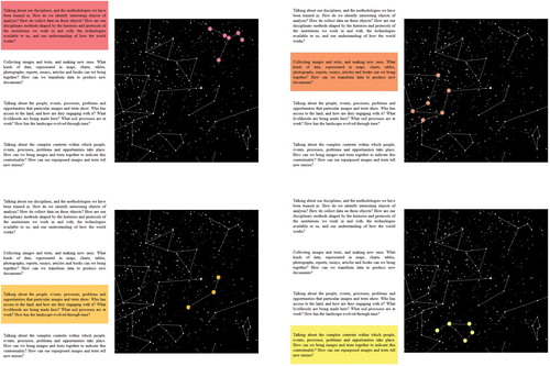
Figure 4. Mapping of the project team's discussion of, and activities for, the Likangala River site.
Another finger touch to the screen reduces the size of the sky map/flow chart, and moves it to the top left-hand corner. Foregrounded now are particular activities that emerged from discussions amongst the team during the Glasgow workshop as to what kinds of data we had shared, and how it might be repurposed. For example, for Tikondwe Freedom Gardens, after an examination of a number of student reports on the soil chemistry and biology of the site (supervised by Moyo) and soil surveys of the region (collected by Long), both had discussed how the soil profile for the farm would have developed, and had annotated a sketch. Nicholson later filmed Long redrawing this soil profile, and the story map image of the paper, pen and hand () becomes, at a touch, a section of this film scored to an extract from Moyo and Long's discussion.
Figure 5. Focusing on a specific activity in the Tikondwe Freedom Gardens story map.
A touch stops the film/audio, and the image reduces in size to become one of several ‘tiles’ (). These provide the viewer with a choice of data, activities and/or discussions to explore, each providing more of an insight into the nature of the site. So, for example, Barrett and Long spent time discussing a vegetation map that was produced using remote sensed imagery from data available from online repositories. Touching the tile opens up the image, but also starts an audio, facilitated by Nicholson, that narrates where the data come from, how the data were accessed and transformed, and how those data may have been collected and collated before being made available to researchers. A similar tile-based format has been used for the Likangala River story map.
Figure 6. Tile entry points in the Tikondwe Freedom Gardens story map.
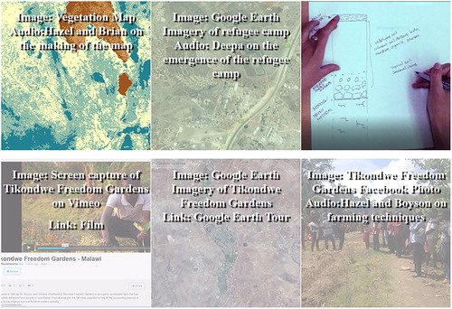
Individually, the tiles showcase a particular substantive issue, using image and/or sound, as well as diverse links to other sites and to particular documents. Some tiles make explicit the fact that their production required work from different disciplines, while others gesture towards the knowledge ecosystems (published papers, online film repositories, social media sharing sites) within which academics live and work, and to which they contribute. Collectively, however, the tiles do not present a more ‘holistic’ accounting for our sites. They remain discrete tiles. As such, they comprise a handful of narratives of site, sometimes overlapping in content or researcher involved in their production, but just as often diverging.
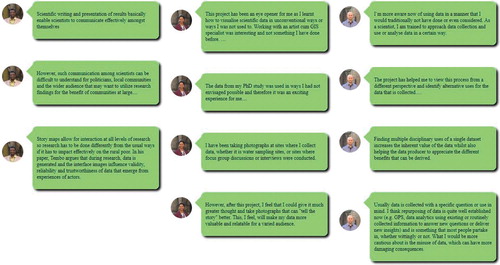
Indeed, it is this sense of resonance and estrangement, commonalities found and eschewed, that permeates our own reflections on the collaborative process. This is an ongoing project, and the final stage will be the integration of our critical reflections into the story maps. We have begun to collect these reflections, with the intent of formatting them as ‘pop up chats’ () that are interspersed through the existing screenshots. These pop ups are not conclusions to appear at the end of a narrative, nor are they pronouncements on what the future holds; instead, they manifest something of our own pauses for thought and, we hope, also give the viewer pause for thought.
Figure 7. Pop up chats to be integrated into the story maps, comprising reflections on the collaborative process.
4. Concluding comments
The project outlined above has brought together people from various disciplines to critically reflect upon, and expand the contexts of, the data produced by diverse scientific expertise. Certainly, the story maps we are working on provide insights into the processes and events present at both Tikondwe Freedom Gardens and the Likangala River. But what we have striven to map using this particular medium is something of the practices that are undertaken, yet often glossed, in the knowledge production process itself, insofar as these sites become knowable within particular conceptual and methodological frameworks. In setting out to actively repurpose our datasets – to undertake a practice-led mapping of these datasets – we have also sought to experiment with knowledge production, producing small narratives of people and place that tell us as much about the nature of these epistemes as they do about the sites.
In doing so, we have formulated some ideas about the project, and the value of art-science collaboration more generally, as indicated in the pop up chats noted above. At the risk of smoothing over the different apprehensions that continue to underlie our project, we would like to conclude by offering some thoughts on art-science collaborations. To begin, we would suggest that there are two key contributions offered by arts practice. First, arts practice can shed light on the embodied, sensuous doings of earth and environmental sciences, but also of GIS. While these aesthetics are crucial to knowledge production in the field and the laboratory, and are indeed rigorously monitored, they remain outside of conventional science reporting. Second, and relatedly, arts practice can foreground the politics of knowledge production – critiquing and even disrupting the power relations that enable and animate research – with a particularly keen appreciation for the politics embedded in visual representations. Next, we would suggest that there are two key contributions offered by the sciences in the collaborative effort. First, the resonances between scientific practice (albeit usually glossed) and arts practice lends itself to a demystifying of the latter; for example, by opening questions around the nature of creativity. Second, and relatedly, the methods undertaken to produce scientific visualisations of site – such as the convention-led production of tabulated, cross-referenced and searchable datasets – prompts consideration of the manner in which a host of people, objects and ideas are also assembled through arts practice, thus decentering the somewhat iconic figure of the artist as creator.
Such contributions are useful, we would add, across the arts and humanities, social and natural sciences. For we must ask: given the wealth of research that points to the magnitude, variety and longevity of human-induced changes to the lithosphere, hydrosphere, cryosphere, biosphere and atmosphere, how can we develop scientific visualisations of process and event that refuse to disambiguate the human from the natural? And, how can we further artistic visualisations of a life lived in the Anthropocene by more carefully considering the range of scientific data sets available on a particular problematic, and their existing, and possible, aesthetics?
Acknowledgements
The project from which this research was drawn was funded by a grant from the Scottish Funding Council (Global Challenge Research Funding) entitled ‘Building Sustainable Futures in Africa: Using capacity-strengthening activities to design and pilot methods for cross disciplinary research’, and proposed by Deborah Dixon, Mia Perry, Daniel Koehn, Neil Burnside, Brian Barrett and Adrian Boyce.
Disclosure statement
No potential conflict of interest was reported by the authors.
ORCID
Philip J. Nicholson http://orcid.org/0000-0003-4131-165X
Deborah Dixon http://orcid.org/0000-0003-0846-6959
Deepa Pullanikkatil http://orcid.org/0000-0003-1685-4548
Boyson Moyo http://orcid.org/0000-0001-6333-3265
Brian Barrett http://orcid.org/0000-0002-4380-4020
Additional information
Funding
Notes
1 While the content used in the story maps is either produced by ourselves or acknowledged, and we intend to disseminate them in the future, the story maps are currently in view only by the project team members while undergoing editing, critique and further elaboration.
2 Our intent was to draw the Likangala River's profile using geolocated elevation data. Inaccuracies in this data set, however, meant that the ensuing profile flowed uphill in our model. The line used has been free-handed.
3 Available at https://www.fourmilab.ch/cgi-bin/Yoursky. Images produced by Your Sky are in the public domain and may be used in any manner without permission, restriction, attribution, or compensation. We would, however, like to attribute the site.
References
- Baker, V., & Twidale, C. (1991). The reenchantment of geomorphology. Geomorphology, 4(2), 73–100. doi: 10.1016/0169-555x(91)90021-2
- Brown, A., Tooth, S., Bullard, J., Thomas, D., Chiverrell, R., Plater, A., … Aalto, R. (2017). The geomorphology of the Anthropocene: Emergence, status and implications. Earth Surface Processes and Landforms, 42(1), 71–90. doi: 10.1002/esp.3943
- Dixon, D., Hawkins, H., & Straughan, E. (2012). Of human birds and living rocks. Dialogues in Human Geography, 2(3), 249–270. doi: 10.1177/2043820612468692
- Dixon, D. P., Hawkins, H., & Straughan, E. R. (2013). Wonder-full geomorphology: Sublime aesthetics and the place of art. Progress in Physical Geography: Earth and Environment, 37, 227–247. doi: 10.1177/0309133312457108
- Dunlap, R. E. (2013). Climate change skepticism and denial: An introduction. American Behavioral Scientist, 57(6), 691–698. doi: 10.1177/0002764213477097
- Fischhoff, B., & Davis, A. (2014). Communicating scientific uncertainty. Proceedings of the National Academy of Sciences, 111(Suppl. 4), 13664–13671. doi: 10.1073/pnas.1317504111
- Fitzgerald, D., & Callard, F. (2015). Social science and neuroscience beyond interdisciplinarity: Experimental entanglements. Theory, Culture & Society, 32(1), 3–32. doi: 10.1177/0263276414537319
- Gordon, J. (2012). Rediscovering a sense of wonder: Geoheritage, geotourism and cultural landscape experiences. Geoheritage, 4(1–2), 65–77. doi: 10.1007/s12371-011-0051-z
- Gordon, J., & Baker, M. (2016). Appreciating geology and the physical landscape in Scotland: From tourism of awe to experiential re-engagement. Geological Society, London, Special Publications, 417(1), 25–40. doi: 10.1144/sp417.1
- Hall, R., Edelman, M., Borras, S., Scoones, I., White, B., & Wolford, W. (2015). Resistance, acquiescence or incorporation? An introduction to land grabbing and political reactions ‘from below’. The Journal of Peasant Studies, 42(3–4), 467–488. doi: 10.1080/03066150.2015.1036746
- Ingold, T. (2013). Making: Anthropology, archaeology, art and architecture. Abingdon: Routledge.
- Last, A. (2012). Experimental geographies. Geography Compass, 6(12), 706–724. doi: 10.1111/gec3.12011
- Lesen, A., Rogan, A., & Blum, M. (2016). Science communication through art: Objectives, challenges, and outcomes. Trends in Ecology & Evolution, 31(9), 657–660. doi: 10.1016/j.tree.2016.06.004
- Moyo, B., & Moyo, D. (2016). Indigenous knowledge perceptions and development practice in Northern Malawi: Lessons from small-scale farmers’ agricultural practices. In P. Ngulube (Ed.), Handbook of research on social, cultural, and educational considerations of indigenous knowledge in developing countries (1st ed.). Hershey, PA: IGI Global Publication. Retrieved from http://www.igi-global.com/book/handbook-research-social-cultural-educational/150440
- Nelson, R. (2013). Practice as research in the arts. Basingstoke: Palgrave Macmillan.
- Nshimbi, C. (2019). Life in the fringes: Economic and sociocultural practices in the Zambia–Malawi–Mozambique borderlands in comparative perspective. Journal of Borderlands Studies, 34, 47–70. doi: 10.1080/08865655.2017.1300780
- Pullanikkatil, D., Palamuleni, L., & Ruhiiga, T. (2015). Impact of land use on water quality in the Likangala catchment, southern Malawi. African Journal of Aquatic Science, 40(3), 277–286. doi: 10.2989/16085914.2015.1077777
- Pullanikkatil, D., Palamuleni, L., & Ruhiiga, T. (2016). Assessment of land use change in Likangala River catchment, Malawi: A remote sensing and DPSIR approach. Applied Geography, 71, 9–23. doi: 10.1016/j.apgeog.2016.04.005
- Zur, J. (1999). Remembering and forgetting: Guatemalan war widows’ forbidden memories. In Trauma and life stories: International perspectives (pp. 45–59). London: Routledge.