
ABSTRACT
Here, a geomorphological map of Horseshoe Island, which is one of the most ice-free islands in Marguerite Bay of the Antarctic Peninsula, is provided. The landforms on the island were mapped by using Google Earth images. Field reconnaissance of the landforms was carried out in March 2018. The island is subdivided into three major geomorphologically different sectors. The northern sector is mostly covered by a remnant of a non-erosive ice cap and has limited glacial landforms and deposits. The central sector is rich in terms of glacial and periglacial landforms and deposits. Glaciers are still sculpting the southern sector and it has extensive features of glacial erosion and deposition. The most common landforms on the island are talus cones, moraines, patterned ground, and raised beaches. The geomorphological map of the island will be a useful base for further geomorphic and/or glaciologic research in this climate-sensitive region.
1. Introduction
The western part of the Antarctic peninsula ((A and B)) is one of the most ice-free areas of the Antartica where glacial and periglacial processes shape the landscape together with glacio-isostatic processes. Several studies have focused on mapping and dating of offshore and onshore geomorphic and geological features across the Antarctic Peninsula (CitationBaroni, Bruschi, & López-Martínez, 1997; CitationBentley et al., 2009, Citation2011; CitationBentley, Hodgson, Smith, & Cox, 2005; CitationClapperton & Sugden, 1982, Citation1983; CitationFretwell, Hodgson, Watcham, Bentley, & Roberts, 2010; CitationGuglielmin, Worland, Convey, & Cannone, 2012; CitationHansom, 1983; CitationHjort & Ingólfsson, 1990; CitationHodgson et al., 2009; CitationJohn & Sugden, 1971; CitationJohnson, Bentley, Roberts, Binnie, & Freeman, 2011; CitationLivingstone et al., 2013; CitationLópez-Martínez, Martínez de Pisón, Serrano, & Arche, 1996; CitationLópez-Martínez et al., 2002; CitationLopez-Martinez, Serrano, Schmid, Mink, & Lines, 2012; CitationMyadkow, 1979; CitationNichols, 1960; CitationOliva et al., 2017; CitationOliva & Ruiz-Fernandez, 2017; CitationÓ Cofaigh, Dowdeswell, Evans, & Larter, 2008; CitationÓ Cofaigh et al., 2005, Citation2014; CitationPallas, Vilaplana, & Sabat, 1995; CitationRoberts et al., 2011; CitationRuckamp, Braun, Suckro, & Blindow, 2011; CitationSeong et al., 2009; CitationSerrano et al., 2008; CitationSerrano & López-Martínez, 1997, Citation2000; CitationSimkins, Simms, & DeWitt, 2013; CitationSugden & John, 1973; CitationWatcham et al., 2011; CitationWolstencroft et al., 2015). Onshore geomorphic mapping efforts have mostly focused on the northern part of the peninsula, e.g. South Shetlands Islands ((B)), but they are very rare in the southern part, e.g. Marguerite Bay. This study focused on Horseshoe Island ((C)) where high-resolution Google Earth images were available and fieldwork was carried out during the second Turkish Antarctic Expedition in March 2018.
Figure 1. Location map of Antarctica (A), Antarctic Peninsula (B) and Horseshoe Island (C).
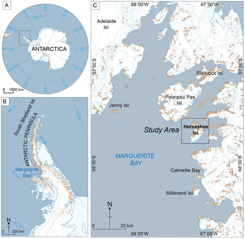
The study area is located within the archipelago of Marguerite Bay located in the south-central part of the Antarctic Peninsula ((C)). The bay was covered by an ice sheet that extended to the continental slope at ca. 20 ka ago (CitationBentley et al., 2011). Two major steps in deglaciation occurred shortly after ca.14.2 ka and ca.10.6 ka that resulted in the removal of the ice-sheet and inundation of the inner part of the bay (CitationÓ Cofaigh et al., 2008). The island was ice-sheet free by ca. 9.5 ka (CitationÇiner et al., 2019). These major climatic events had substantial consequences on surface processes across the bay.
Horseshoe Island is the third largest island within the Marguerite Bay archipelago. Pourquoi Pas, Horseshoe and Millerand islands together with Calmette Bay are the most promising areas in terms of glacial, periglacial landscape evolution and glacio-isotatic investigations because of well-preserved landforms and deposits. ((C)). The total surface area of Horseshoe Island is 60 km2 and glaciers or semi-perennial ice and snow cover 66% of the island. The highest peaks on the island are Mount Searle (537 m a.s.l.) and Mount Breaker (879 m a.s.l). Mount Searle is a pyramidal individual mountain located at the northern sector of the island. There is a col at the central part of the island, which is an ice-free saddle between its northern and southern sectors (). The plateau surface of the central col is around 80–90 m a.s.l and five freshwater lakes are situated on the plateau (Main Map). This part of the Antarctic Peninsula is under the cold and dry maritime climate (CitationOchyra, Lewis, Smith, & Bednarek-Ochyra, 2008). Meteorological measurements close to Horseshoe Island at Rothera (between 1977 and 2015) and San Martin (between 1985 and 2015) stations reveal mean annual air temperatures as −4.3°C and −4.6°C, respectively (CitationOliva et al., 2017).
Figure 2. Geological map of Horseshoe Island on Google Earth Image. Date of the image is 2012. Lithological, tectonics and structural features are adapted from CitationMatthews (1983).
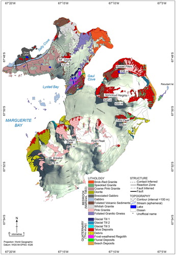
The bedrock geology of Horseshoe Island is comprised of mainly felsic igneous rocks such as white, pink, brick-red and speckled granites and diorite together with mafic igneous rocks such as gabbro and undifferentiated volcanic rocks (CitationMatthews, 1983, ). Quaternary deposits include till within moraines, erratic blocks on bedrocks, debris cover on glaciers, talus deposits along mountain fronts and cliffs, frost-shattered rocks and regoliths, beach deposits and fluvial deposits of braided streams (Main Map).
In this topographical and geological setting, geomorphic features are unevenly distributed on the island. The southern part of the island is much higher and rugged compared to the northern and central sectors of the island. Erosional glacial landforms such as nunataks, horns, arrètes, glacial steps, cirques and truncated spurs are more common on the southern sector. On the other hand, periglacial landforms such as frost shattered bedrocks, patterned ground and talus cones are concentrated on the central and northern sectors. The western and eastern coasts of the central col comprise well-preserved uplifted shorelines as an indicator of glacio-isostatic processes. Two unnamed glaciers were dedicated to prominent Turkish glaciologists and geomorphologists, Professor Reşat İzbırak and Professor Sırrı Erinç.
2. Data and methods
The geomorphological map of Horseshoe was generated through combination of remote sensing and field mapping (Main Map). Remote sensing mapping was conducted using Google EarthTM images acquired on 24 February 2012, 30 December 2011 and 31 December 2009 with different light and cloud conditions. The geometry of landforms was defined by using three-dimensional visualization features of Google EarthTM Pro. Open layers plugin in QGIS 2.18 allows users to open a 10 m contour interval map of Open Street Map Thunder Forest Landscape (available at http://tile.thunderforest.com/landscape) and Google MapsTM images to define the areal extent of the geomorphic units. Major landform units were digitized by hand tracing their outlines using QGIS 2.18. Ground control of the reference landforms were verified using a handheld Global Positioning System with a horizontal accuracy of ±3 m. The detailed ground controls allowed identification of micro geomorphic features such as sorted stone polygons, striations, and erratic boulders which are impossible to map by using only remote sensing data. Landforms were grouped based on processes that formed them such as glacial, periglacial, glacio-fluvial, coastal and glacio-isotatic processes. The order of the legend was designed according to those landforms and processes. The bedrock geology and structures such as faults are adapted from CitationMatthews (1983). Topographic contours with a 100 m interval and geomorphological features are draped as lines over the Google MapsTM image. The scale of the Main Map is defined as 1:25,000. All data are stored within Q-GIS 2.18 (www.QGIS.com) and locator maps within were adapted from Quantarctica V3 (http://quantarctica.npolar.no), a free GIS package for research, education, and operation in Antarctica. The final version of the main map was designed in Adobe Illustrator® CS6.
3. Results
3.1. Landforms and deposits associated with glacial processes
The five types of glaciers occurring on the island are ice cap, hanging, piedmont, debris-covered and tide glaciers (Main Map). Although glacial processes are most important in sculpting the landscape, they are not uniformly distributed on Horseshoe Island. The northern sector has an ice-cover that does not display classical erosional features such as ‘U’ shaped valleys or classical depositional features such as moraines (Main Map, and (A)). Instead, the spatial pattern of the ice-body resembles what is left from a non-erosive ice cap ((A and B)). The only prominent glacial landform is Mount Searle, a nunatak made up of gabbro and volcanic tuff, which rises in the middle of this ice cap ((A and B)).
Figure 3. (A) General view of Horseshoe Island from the west, (B) View southern part of Searle Ice Cap from Central Col, (C) View of Moraine 1 ridge and Col Lake 3 from south. (D), An example of erratic boulders, (E) Ice striations on bedrock surfaces.
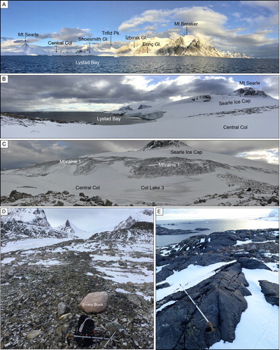
The central col is richer in terms of paleoglacial, and periglacial deposits and landforms (Main Map). The plateau of the central col resembles a subtle knock and lochan topography with irregular depressions and bosses as a subglacial footprint of areal scouring. Till of this paleoglacial activity is not well preserved because of periglacial activity especially on the plateau of the central col. This till is the source of the finer material in sorted polygons now. Nevertheless, till within an east–west oriented high moraine ridge defines the boundary between the central col and northern sector (Main Map and (C)). The length of this moraine is 890 m and reaches up to 120 m a.s.l. There was no well-exposed outcrop to observe till sedimantology but its surface is made up dominantly of cobble and boulder size gabbro, pink and gray granite clasts. Erratic blocks with 1–1.5 m diameter and cobbles are other paleoglacial deposits, which are generally brick-red and pink colored granites observed from Gaul Cove to Lystad Bay ((D)). In addition to depositional glacial features, it is also possible to observe striations on bedrock surfaces associated with the paleo-glacier that carved the central col ((E)). These are mm scale deep striations trending from SE to NW and E to W, orientations that are consistent with thicker ice flow from the axis of the Antarctic Peninsula.
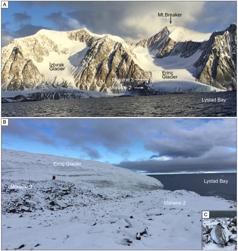
The southern sector is the richest part of the island in terms of glacial landforms and deposits. The largest glacier in the southern sector is Shoesmith Glacier (Main Map). It has two branches, one flowing into Gaul Cove and the other into Lystad Bay. Both are tide-water glaciers. Major erosional landforms in this sector are horns, cirques, glacial steps, arrètes, truncated spurs and ‘U’ shaped valleys (Main Map). The summits of Mt. Breaker, Penitent Peak, Ryan Peak and Trifid Peak are typical pyramidal horns. Cirques are located at the upstream part of the U-shape of the Erinç and İzbırak (unofficial names) glacial valleys. The glaciers are sourced from these cirques that flow down on glacial steps. Arrètes usually strike from south to north between horns to the apex of the truncated spurs. Truncated spurs are triangular and steep slopes face toward the north to Lystad Bay. They indicate contact between paleo-trunk and tributary glaciers. Terminal and lateral moraines are the most common depositional glacial features along the southern sector. The terminal moraine of Shoesmith Glacier defines the boundary between the southern and central sectors (Main Map and (A)). Shoesmith Glacier has a 12–15 m high ice-wall rising a few tens of meters to the south of the terminal moraine, marking its recent retreat ((B and C)). The top surface (Main Map) and ice-wall ((B and C)) at the toe of Shoesmith Glacier are clean in terms of transported material indicating no supra-or englacial transportation along the glacier. Therefore, this terminal moraine must have been built as a result of subglacial transportation as it is seen in (C). The till of the moraine is made up of boulders, cobbles and pebbles of various pink to white granites ((B and C)). Other major glaciers have characteristic ‘U’ shaped valleys. Erinç Glacier is a well-developed piedmont glacier with a ‘U’ shaped upstream valley and a fan-shaped downstream end with terminal and lateral moraines ((A)). It is a piedmont glacier and its right lateral moraine and half of its terminal moraine, which has two levels, are evident ((B)). There is very limited supraglacial transportation along Erinç Glacier, and therefore most of the tills are transported mainly by subglacial and partly englacial transportation. The till is made up of dominantly angular boulders ((C)). Apart from Shoesmith, there is a hanging glacier just west of the Erinç Glacier that does not reach the ocean (). Its terminus has a talus cone form instead of a moraine. İzbırak Glacier is another glacier that terminates in the ocean (Main Map and 5A). The surface of this glacier, especially at the mid- and downstream sections, is mantled in debris sourced mainly from the eastern slopes of the valley ((A)). The geometry of crevasses and debris ridges (Main Map) at the terminus indicate the deviation of its flow due to the westward flow of Shoesmith Glacier. The southern flank of the southern sector is marked by tide-water glaciers. In a few places, their moraines are also partially exposed (Main Map). The terminal moraine ridge located on the southeast coast of the island is the largest glacial depositional landform in the southern flank of the southern sector (Main Map). The presence of several moraine ridge crests on it indicates recent recession of this glacier. Overall, moraines cover 2.5% of ice-free areas, with distribution especially on the central and southern parts of the island.
Figure 4. Panoramic view of Lystad Bay branch of (A) Shoesmith Glacier, (B) Terminal and (C) Lateral moraines of Shoesmith Glacier.
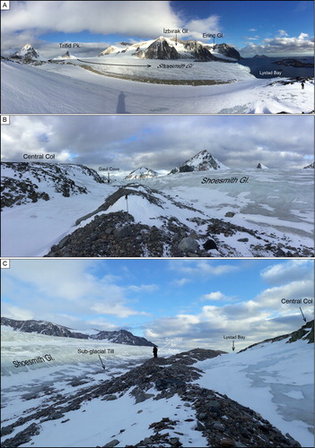
Figure 5. (A) General view of Erinç Glacier, (B) Close-up view of moraine ridges in front of the Erinç Glacier, (C) An example of pink granite boulder within the till.
3.2. Landforms and deposits associated with periglacial processes
Ice-free parts of Horseshoe Island are exposed to intense periglacial conditions. The begining of periglacial conditions on Horseshoe Island, based on the transition from glacio-lacustrine to lacustrine sediments in lakes, is ca. 10.6 ka BP (CitationHodgson et al., 2013). The most common periglacial process on the island is bedrock frost shattering as a result of repeated freezing and thawing cycles ((A)). Frost- shattering breaks down basement rocks and/or erratic boulders form sharp, angular and shallow mantle of in situ bouldery regolith at the surface ((B)). Ongoing weathering processes disintegrate this debris, forming sub-angular clasts that are reworked together with till deposits into patterned ground ((C–F)) as a result of cryoturbation. The most common patterned ground features are sorted stone polygons on flat surfaces ((C–E)) and unsorted stone polygons ((F)). They are observed especially in flat areas on the plateau of the central col around freshwater lakes (Main Map). Sorted stone polygons are usually centerd by fines and rimmed by cobblestones. The radius of these sorted stone polygons varies between 90 and 140 cm ((C–E)). The lichen-free surfaces of stone clasts and their loose connections imply active cryoturbation processes. Unsorted stone polygons ((F)) that are rimmed by unsorted stones and are centerd by very fine (e.g. sand, silt) particles are other examples of patterned ground on the island. These are smaller features relative to sorted stone polygons and their radii vary between 40 and 60 cm ((F)). These features are the surface expression of permafrost on the island and develop only on the plateau of the central col, suggesting that the altitude and flat topography are important factors affecting their distribution. They are distributed at elevations between 80 and 90 m a.s.l and cover less than 1% of the ice-free areas only on the plateau of the central col.
Figure 6. (A) An example of frost-shattering of a single block, (B) frost-shattering of the bedrock surfaces. (C–E) sorted stone polygons with different lithologies, (F) unsorted polygon type patterned grounds.
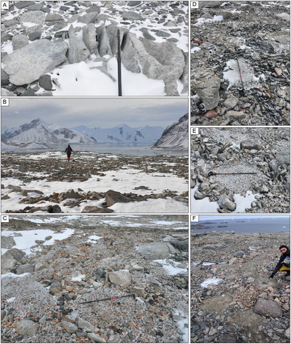
Figure 7. (A) General view of truncated spurs and talus fans at the western flank of the southern sector, (B and C) boulder and sand-size clasts in taluvium, (D) Oblique view of the talus cones, protalus ramparts, rock ploughing, solifluction sheets and rock slide tongue (see Main Map for location of protalus rampart).
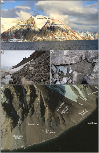
The products of frost-shattering on steep slopes produce angular frost-shattered fragments. They form very steep talus cones especially along the north facing slopes and also the cliffs of the southeastern part of the island (Main Map). These cones are formed by colluvial; medium dense silty, sandy angular gravel, cobbles and boulders, at their mid- and downstream parts. In the western part of the southern sector, talus cones have a more radial shape with their widths changing between 200 and 300 m and lengths between 250 and 350 m. The rest of the talus cones are more elongated, with widths between 100 and 150 m and lengths between 300 and 500 m. They are usually 100 m high but in the southern coast of the Gaul Cove some of the talus cones reach 300 m a.s.l. The coarse and rubble forms of the talus cones together with absence of lichen colonization indicate a rapid block production on the island. The talus cones cover 8% of the ice-free parts of the island as the most common depositional landforms. A protalus rampart, rock slides, rock ploughing, and solifluction sheets are other geomorphic features associated with periglacial processes acting on ice-free slopes ((D)). Solifluction sheets form on gentler slopes and their long axis is parallel to slope contour. They are very rare on Horseshoe and only identified between the foot of a talus cone and protalus rampart at the south-eastern part ((D)) indicating frost creep at the eastern part of the island (Main Map). All the geomorphic features reveal ongoing periglacial activity on the island together with spatially variable permafrost conditions at this latitude (67°S).
3.3. Landforms and deposits associated with glacio-fluvial processes
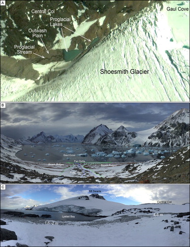
Fluvial activity is one of the common phenomena in periglacial conditions. There are four ephemeral streams on Horseshoe Island. The smallest one is located between Shoesmith Glacier and bedrock of the central col (Main Map and (A)). It is discharged from Shoesmith and forms a small outwash plain and sheds into a triangular shaped pro-glacial lake confined between subglacial tills of Shoesmith Glacier and talus cones of the central col. The best exposed larger ephemeral stream flows to Gaul Cove from the eastern slope of the central sector (Main Map and (B)). The valley of this stream, which is around 500 m long, transports debris from slopes and distributes them over the raised beach ridges. The floodplain of the stream is around 20–30 m wide with a braided channel pattern ((B)). This stream also incises 1.5 m into the older beach ridges. The floodplain of this stream ends with a fan delta that sheds into the Gaul Cove (Main Map and (B)). Further fluvial activity is located south of the Skua Lake and near northeast of the Gaul Cove. This latter fluvial activity overlies older glacial landforms and sediments. Fluvial landforms cover less than 1% of the ice-free areas and they are mostly distributed on the northern and central sectors.
Figure 8. (A) Google Earth view of the proglacial stream, outwash plain and proglacial lakes in front of the Shoesmith Glacier, (B) General view of the raised beach ridges and fan delta at the Gaul Cove. Dashed blue lines indicate ephemeral streams and dashed green lines delimit boundary between raised beach ridges and flood plain and fan delta, (C) General view of the raised beaches at the Lystad Bay.
3.4. Landforms and deposits associated with coastal processes
Since Horseshoe Island is in maritime Antarctica, the coastal features are important geomorphic markers associated with the interaction between glaciers, ocean and glacio-isostatic processes. There are a multitude of shoreline classifications in general, but I classified the shoreline of the island as ice-covered, erosional and depositional. The total length of the shoreline of Horseshoe Island is 63 and 23 km of it is ice-covered. Ice-covered shorelines occupy large areas especially along the southern coasts, Lystad Bay and Gaul Cove. In a few locations exposure of bedrock or moraines interrupt ice-covered shores along the southern coasts and Lystad Bay (Main Map). The length of the ice-free shoreline is 40 km. Erosional shorelines occupy 53% and depositional shorelines occupy 47% of the ice-free shorelines. Beaches and raised beach ridges cover 3% of the ice-free areas on Horseshoe Island. Ice-free shorelines are mostly erosional especially along the coasts of the northern sector. These coasts are characterized by direct contact of high-relief bedrock cliffs to ocean without any depositional features in front and small rocky islets. These active cliffs are rarely interrupted by pocket beaches covered by a thin mantle of water-worn boulders and cobbles. The remaining ice-free coasts of the island are also mainly high-relief bedrock coast but they have no direct contact to the ocean. Depositional features such as talus cones, moraines, beach and fluvial deposits prevent basal contact of these cliffs to the ocean. These types of shores start with very narrow strip of shingle beaches or direct contact of steep talus cones to ocean especially along the northern and eastern coast of the southern sector. There are also glacial deposits that reach the ocean. The largest one is located in the southeast of Russet Pikes (Main Map). This is a terminal moraine delimited by a narrow strip of beach in front but it is evident that beach deposits are composed of reworked moraine material. Other shorelines coincident with moraines occur at the lateral moraines located south of Trifid Peak, right lateral and terminal moraines of Erinç Glacier in Lystad Bay. The right lateral moraines of Shoesmith Glacier in Gaul Cove, and right and left lateral moraines of the glacier sheds into Gaul Cove from Spincloud Heights (Main Map). These moraines are a result of glacial retreat.
3.5. Landforms and deposits associated with glacio-isostatic processes
The thinning and/or removal of glaciers has been compensated by isostatic rebound and rock uplift. CitationHjort and Ingólfsson (1990) found an uplifted marine limit at ca. 55 m a.s.l on Horseshoe Island. Geomorphic markers of this rebound are raised beach ridges along the shingle beaches (CitationBentley et al., 2005; CitationFretwell et al., 2010; CitationHodgson et al., 2013; CitationSimkins et al., 2013). Raised beach ridges are mapped at four locations along the coasts of the island (Main Map) but only two of them were accessible during the fieldwork. Those are located at the coasts at the Lystad Bay and Gaul Cove (Main Maps and (B and C)). Two levels of shingle beaches were identified at 1.5–2 m and 4–5 m a.s.l. at Lystad Bay ((C)). The highest level is made up of granite boulders but another level is granite, gneiss and gabbro cobbles. However, 12 different beach ridges up to 22.4 m at Gaul Cove are very evident. These beach ridges are made up dominantly of brick-red colored granites, making them easily distinguishable ((B)). There are also two more raised beaches on the eastern coast of the northern sector (Main Map) but there are no a reliable measurement of their elevations.
4. Discussion and conclusion
The overall geomorphology of Horseshoe Island reveals differences in terms of type and distribution of glacial and periglacial landforms. There are three different geomorphologic sectors on the island; northern, central and southern. The northern and southern sectors are still under the influence of glaciers. A non-erosive ice cap covers most of the northern sector without displaying classical glacial geomorphological features. In contrast, the southern sector is sculpted by hanging, piedmont (Erinç), debris-covered (İzbırak) and tide-water glaciers (Shoesmith). These glaciers form steep and deep ‘U’ shaped valleys and sharp horns, cirques, arrètes and truncated spurs. Frost-shattered bedrocks, patterned grounds, talus cones, protalus ramparts, and solifluction sheets are periglacial landforms that can be observed on the island. Patterned grounds are restricted to flatter areas at 80–90 m.a.s.l in the central col and their areal coverages are very limited (Main Map). Frost actions and patterned grounds, such as sorted stone polygons and unsorted polygon debris islands are typical surface features of permafrost on the island. In addition to glacial and periglacial processes and landforms, fluvial, coastal and isostatic landforms are also evident on the island. The presence of raised beach ridges along several coasts indicate the interaction of coastal and glacio-isostatic processes as a consequence of unloading of the island and its surroundings. The geomorphological map of the island shows the geometry and pattern of these landforms and is a useful base for further geomorphic and/or glaciological research.
Software
Quantum GIS 2.18. Las Palmas de G.C was utilized to display Google Earth Image and digitizing geomorphic features. Adobe Illustrator CS6Ò was used to design final editing of the 1:25,000 scale map.
GEOMORPHOLOGICAL MAP OF HORSESHOE ISLAND, MARGUERITE BAY, ANTARCTICA
Download PDF (49.6 MB)Acknowledgements
This study was carried under the auspices of Turkish Republic Presidency, supported by the Ministry of Science, Industry, and Technology, and coordinated by Istanbul Technical University (ITU) Polar Research Center (PolReC). I would like to thank Attila Çiner for his company during fieldworks and for providing some of the pictures. I would also like to express my gratitude to Burak Karacık for providing some photos of the taken during the first Turkish Antarctic Expedition in April 2017. Many thanks to Manja Žebre and Uroš Stepišnik for their comments on the main map and the manuscript of the paper and further thanks to Chandra Jayasuriya, Mauro Guglielmin, Jasper Knight, John Abraham, Jeronimo Lopez-Martinez, David Edward Sugden and Brent Ward for their useful and constructive evaluations that significantly improved the manuscript.
Disclosure statement
No potential conflict of interest was reported by the author.
Correction Statement
This article has been republished with minor changes. These changes do not impact the academic content of the article.
Additional information
Funding
Related Research Data
References
- Baroni, C. , Bruschi, G. , & López-Martínez, J. (1997). Review of antarctic geomorphological mapping. Geografia Fisica e Dinamica Quaternaria , 20 , 15–31.
- Bentley, M. J. , Hodgson, D. A. , Smith, J. A. , & Cox, N. J. (2005). Relative sea level curves for the South Shetland Islands and Marguerite Bay, Antarctic Peninsula. Quaternary Science Reviews , 24 (10–11), 1203–1216. doi: 10.1016/j.quascirev.2004.10.004
- Bentley, M. J. , Hodgson, D. A. , Smith, J. A. , Ó Cofaigh, C. , Domack, E. W. , Larter, R. D. , … Evans, J. (2009). Mechanisms of Holocene palaeoenvironmental change in the Antarctic Peninsula region. The Holocene , 19 (1), 51–69. doi: 10.1177/0959683608096603
- Bentley, M. J. , Johnson, J. S. , Hodgson, D. A. , Dunai, T. , Freeman, S. P. H. T. , & Ó Cofaigh, C. (2011). Rapid deglaciation of Marguerite Bay, Western Antarctic Peninsula in the Early Holocene. Quaternary Science Reviews , 30 (23–24), 3338–3349. doi: 10.1016/j.quascirev.2011.09.002
- Clapperton, C. M. , & Sugden, D. E. (1982). Late quaternary glacial history of george VI sound area, West Antarctica. Quaternary Research , 18 , 243–267. doi: 10.1016/0033-5894(82)90074-6
- Clapperton, C. M. , & Sugden, D. E. (1983). Geomorphology of the Ablation Point Massif, Alexander Island, Antarctica. Boreas , 12 , 125–135. doi: 10.1111/j.1502-3885.1983.tb00443.x
- Çiner, A. , Yıldırım, C. , Sarıkaya, M. A. , Seong, Y. B. , Byung, Y. Y. 2019. 10Be cosmogenic dating of glacial erratic boulders on Horseshoe Island in western Antarctic Peninsula confirm the rapid deglaciation in Early Holocene. Antarctic Science, 31, 6, 319–331. doi:10.1017/S0954102019000439.
- Fretwell, P. T. , Hodgson, D. A. , Watcham, E. P. , Bentley, M. J. , & Roberts, S. J. (2010). Holocene isostatic uplift of the South Shetland Islands, Antarctic Peninsula, modelled from raised beaches. Quaternary Science Reviews , 29 (15–16), 1880–1893. doi: 10.1016/j.quascirev.2010.04.006
- Guglielmin, M. , Worland, M. R. , Convey, P. , & Cannone, N. (2012). Schmidt Hammer studies in the maritime Antarctic: Application to dating Holocene deglaciation and estimating the effects of macrolichens on rock weathering. Geomorphology , 155–156 , 34–44.
- Hansom, J. D. (1983). Radiocarbon dating of a raised beach at 10 m in the South Shetland Islands, Antarctica. Marine Geology , 53 , 211–229. doi: 10.1016/0025-3227(83)90075-0
- Hjort, C. , & Ingólfsson, Ó . (1990). Studies of the glacial history in the Antarctic Peninsula area. In A. Karlqvist (Ed.), Swedish antarctic research programme 1988/89. A cruise report (pp. 76–80). Stockholm : Swedish Polar 234 Glacial history of the Antarctic Peninsula Research Secretary.
- Hodgson, D. A. , Roberts, S. J. , Bentley, M. J. , Smith, J. A. , Johnson, J. S. , Verleyen, E. , … Sanderson, D. C. W. (2009). Exploring former subglacial Hodgson Lake, Antarctica paper I: Site description, geomorphology and limnology. Quaternary Science Reviews , 28 (23–24), 2295–2309. doi: 10.1016/j.quascirev.2009.04.011
- Hodgson, D. A. , Roberts, S. J. , Smith, J. A. , Verleyen, E. , Sterken, M. , Labarque, M. , … Bryant, C. (2013). Late Quaternary environmental changes in Marguerite Bay, Antarctic Peninsula, inferred from lake sediments and raised beaches. Quaternary Science Reviews , 68 , 216–236. doi: 10.1016/j.quascirev.2013.02.002
- John, B. S. , & Sugden, D. E. (1971). Raised marine features and phases of glaciation in the South Shetland Islands. British Antarctic Survey Bulletin , 24 , 45–111.
- Johnson, J. S. , Bentley, M. J. , Roberts, S. J. , Binnie, S. A. , & Freeman, S. P. H. T. (2011). Holocene deglacial history of the northeast Antarctic Peninsula - A review and new chronological constraints. Quaternary Science Reviews , 30 (27–28), 3791–3802. doi: 10.1016/j.quascirev.2011.10.011
- Livingstone, S. J. , Ó Cofaigh, C. , Stokes, C. R. , Hillenbrand, C.-D. , Vieli, A. , & Jamieson, S. S. R. (2013). Glacial geomorphology of Marguerite Bay Palaeo-Ice stream, Western Antarctic Peninsula. Journal of Maps , 9 (4), 558–572. doi: 10.1080/17445647.2013.829411
- López-Martínez, J. , Martínez de Pisón, E. , Serrano, E. , & Arche, A. (1996). Geomorphological map of Byers Peninsula, Livingston Island . BAS Geomap Series. Sheet 5-A. Cambridge : British Antarctic Survey.
- López-Martínez, J. , Headland, R. K. , Hernández-Cifuentes, F. , Maestro, A. , Millar, I. L. , Rey, J. , … Thomson, J. W. (2002). Geology and geomorphology of Deception Island . Cambridge: British Antarctic Survey.
- Lopez-Martinez, J. , Serrano, E. , Schmid, T. , Mink, S. , & Lines, C. (2012). Periglacial processes and landforms in the South Shetland Islands (Northern Antarctic Peninsula region). Geomorphology , 155–156 , 62–79. doi: 10.1016/j.geomorph.2011.12.018
- Matthews, D. W. (1983). The geology of Horseshoe and Lagotellerie Islands, Marguerite Bay, Graham Land. British Antarctic Survey Bulletin , 52 , 125–154.
- Myadkow, S. M. (1979). Geomorphological map of Antarctica to the scale 1:15 000 000. Udc, 551.4. (99), 268–274.
- Nichols, R. L. (1960). Geomorphology of Marqueritye Bay area, Palmer Peninsula, Antarctica. Bulletin American Geological Society , 71 , 1421–1460. doi: 10.1130/0016-7606(1960)10[1421:GOMBAP]2.0.CO;2
- Ochyra, R. , Smith, R. I. L. , & Bednarek-Ochyra, H. (2008). The illustrated Moss Flora of Antarctica ( p. 685). Cambridge : Cambridge University Press.
- Ó Cofaigh, C. , Davies, B. J. , Livingstone, S. J. , Smith, J. A. , Johnson, J. S. , Hocking, E. P. , … Simms, A. R. (2014). Reconstruction of ice-sheet changes in the Antarctic Peninsula since the Last Glacial Maximum. Quaternary Science Reviews , 100 , 87–110. doi: 10.1016/j.quascirev.2014.06.023
- Ó Cofaigh, C. , Dowdeswell, J. A. , Allen, C. S. , Hiemstra, J. F. , Pudsey, C. J. , Evans, J. , & Evans, D. J. A. (2005). Flow dynamics and till genesis associated with a marine-based Antarctic palaeo-ice stream. Quaternary Science Reviews , 24 (5), 709–740. doi: 10.1016/j.quascirev.2004.10.006
- Ó Cofaigh, C. , Dowdeswell, J. A. , Evans, J. , & Larter, R. D. (2008). Geological constraints on Antarctic palaeo-ice-stream retreat. Earth Surface Processes and Landforms , 33 (4), 513–525. doi: 10.1002/esp.1669
- Oliva, M. , Navarro, F. , Hrbáček, F. , Hernández, A. , Nývlt, D. , Pereira, P. , … Trigo, R. (2017). Recent regional climate cooling on the Antarctic Peninsula and associated impacts on the cryosphere. Science of the Total Environment , 580 , 210–223. doi:10.1016/j.scitotenv.2016.12.030.
- Oliva, M. , & Ruiz-Fernandez, J. (2017). Geomorphological processes and frozen ground conditions in Elephant Point (Livingston Island, South Shetland Islands, Antarctica). Geomorphology , 293 , 368–379. doi: 10.1016/j.geomorph.2016.01.020
- Pallas, R. , Vilaplana, J. M. , & Sabat, F. (1995). Geomorphological and neotectonic features of Hurd Peninsula, Livingston Island, South Shetland Islands. Antarctic Science , 7 (4), 395–406. doi: 10.1017/S0954102095000551
- Roberts, S. J. , Hodgson, D. A. , Sterken, M. , Whitehouse, P. L. , Verleyen, E. , Vyverman, W. , … Moreton, S. G. (2011). Geological constraints on glacio-isostatic adjustment models of relative sea-level change during deglaciation of Prince Gustav Channel, Antarctic Peninsula. Quaternary Science Reviews , 30 (25–26), 3603–3617. doi: 10.1016/j.quascirev.2011.09.009
- Ruckamp, M. , Braun, M. , Suckro, S. , & Blindow, N. (2011). Observed glacial changes on the King George Island ice cap, Antarctica, in the last decade. Global and Planetary Change , 79 (1–2), 99–109. doi: 10.1016/j.gloplacha.2011.06.009
- Seong, Y. B. , Owen, L. A. , Lim, H. S. , Yoon, H. I. , Kim, Y. , Lee, Y. I. , & Caffee, M. W. (2009). Rate of late Quaternary ice-cap thinning on King George Island, South Shetland Islands, West Antarctica defined by cosmogenic 36Cl surface exposure dating. Boreas , 38 (2), 207–213. doi: 10.1111/j.1502-3885.2008.00069.x
- Serrano, E. , & López-Martínez, J. (1997). Geomorfología de la Península Coppermine, Isla Robert, islas Shetland del Sur, Antártida. Serie Cientifica Instituto Antarctica Chileno , 47 , 19–29.
- Serrano, E. , & Lopez-Martinez, J. (2000). Rock glaciers in the South Shetland islands, western Antarctica. Geomorphology , 35 (1–2), 145–162. doi: 10.1016/S0169-555X(00)00034-9
- Serrano, E. , López-Martínez, J. , Cuchí, J. A. , Durán, J. J. , Mink, S. , & Navas, A. (2008). Permafrost in the South Shetland Islands (Maritime Antarctica): Spatial distribution pattern. In D. L. Kane & K. M. Hinkel (Eds.), Proceedings of 9th international conference on permafrost 2 (pp. 1621–1625). Alaska, USA: University of Alaska Fairbanks.
- Simkins, L. M. , Simms, A. R. , & DeWitt, R. (2013). Relative sea-level history of Marguerite Bay, Antarctic Peninsula derived from optically stimulated luminescence-dated beach cobbles. Quaternary Science Reviews , 77 , 141–155. doi: 10.1016/j.quascirev.2013.07.027
- Sugden, D. E. , & John, B. S. (1973). The ages of glacier fluctuations in the South Shetland Islands, Antarctica. Palaeoecology of Africa, the Surrounding Islands and Antarctica, No. 8 (pp. 141–159). Cape Town : Van Zinderen Bakker, E.M. Balkema.
- Watcham, E. P. , Bentley, M. J. , Hodgson, D. A. , Roberts, S. J. , Fretwell, P. T. , Lloyd, J. M. , … Moreton, S. G. (2011). A new Holocene relative sea level curve for the South Shetland Islands, Antarctica. Quaternary Science Reviews , 30 (21–22), 3152–3170. doi: 10.1016/j.quascirev.2011.07.021
- Wolstencroft, M. , King, M. A. , Whitehouse, P. L. , Bentley, M. J. , Nield, G. A. , King, E. C. , … Gunter, B. C. (2015). Uplift rates from a new high-density GPS network in Palmer Land indicate significant late Holocene ice loss in the southwestern Weddell Sea. Geophysical Journal International , 203 (1), 737–754. doi: 10.1093/gji/ggv327